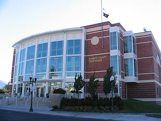
Klamath County is a county in the U.S. state of Oregon. As of the 2010 census, the population was 66,380. The county seat is Klamath Falls. The county was named for the Klamath, the tribe of Native Americans living in the area at the time the first European explorers entered the region.

Crater Lake is a crater lake in south-central Oregon in the western United States. It is the main feature of Crater Lake National Park and is famous for its deep blue color and water clarity. The lake partly fills a nearly 2,148-foot (655 m)-deep caldera that was formed around 7,700 years ago by the collapse of the volcano Mount Mazama. There are no rivers flowing into or out of the lake; the evaporation is compensated for by rain and snowfall at a rate such that the total amount of water is replaced every 250 years. With a depth of 1,949 feet (594 m), the lake is the deepest in the United States. In the world, it ranks ninth for maximum depth, and third for mean (average) depth.

Chiloquin is a city in Klamath County, Oregon, United States. Chiloquin was the pioneer version of a Klamath family name Chaloquin, which was the name of a Klamath chief who was alive at the time of the treaty of 1864. Southern Pacific records also show that a woman named Bessie Chiloquin deeded a right-of-way through the area to the railroad on February 14, 1914. The population was 734 at the 2010 census.

The Rogue River in southwestern Oregon in the United States flows about 215 miles (346 km) in a generally westward direction from the Cascade Range to the Pacific Ocean. Known for its salmon runs, whitewater rafting, and rugged scenery, it was one of the original eight rivers named in the Wild and Scenic Rivers Act of 1968. Beginning near Crater Lake, which occupies the caldera left by the explosive volcanic eruption of Mount Mazama, the river flows through the geologically young High Cascades and the older Western Cascades, another volcanic province. Further west, the river passes through multiple exotic terranes of the more ancient Klamath Mountains. In the Kalmiopsis Wilderness section of the Rogue basin are some of the world's best examples of rocks that form the Earth's mantle. Near the mouth of the river, the only dinosaur fragments ever discovered in Oregon were found in the Otter Point Formation, along the coast of Curry County.
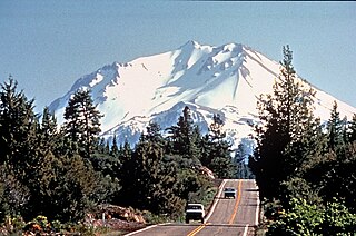
U.S. Route 97 is a major north–south United States highway in the western United States. It begins at a junction with Interstate 5 at Weed, California, and travels north, ending in Oroville in Okanogan County, Washington, at the Canada–US border, across from Osoyoos, British Columbia, becoming British Columbia Highway 97 upon entering Canada. Major cities that lie on US 97 include Klamath Falls, Bend, and Redmond in Oregon and Yakima, Ellensburg, and Wenatchee in Washington.

The Williamson River of south-central Oregon in the United States is about 100 miles (160 km) long. It drains about 3,000 square miles (7,800 km2) east of the Cascade Range. Together with its principal tributary, the Sprague River, it provides over half the inflow to Upper Klamath Lake, the largest freshwater lake in Oregon. The lake's outlet is the Link River, which flows into Lake Ewauna and the Klamath River.
U.S. Route 97 in the U.S. state of Oregon is a major north–south United States highway which runs from the California border, south of Klamath Falls, to the Washington border on the Columbia River, between Biggs Junction, Oregon and Maryhill, Washington. Other than the northernmost stretch, US 97 is known as The Dalles-California Highway. In May 2009, Oregon Senate passed a bill to rename US 97 as "World War II Veterans Historic Highway".

Oregon Route 140 is a state highway in southern Oregon, United States. It is the longest state highway in Oregon, running 237 miles (381 km) from the community of White City, Oregon, through Klamath Falls and on to Lakeview. It then continues east, eventually descending into the state of Nevada.
The Volcanic Legacy Scenic Byway is a scenic highway and All-American Road in the U.S. states of California and Oregon. It is roughly 500 miles (804.7 km) long and travels north–south along the Cascade Range past numerous volcanoes. It is composed of two separate National Scenic Byways, the Volcanic Legacy Scenic Byway - Oregon and Volcanic Legacy Scenic Byway - California. The latter also wholly includes the Lassen Scenic Byway.

Oregon Route 39 is an Oregon state highway that runs between the city of Klamath Falls in Southern Oregon, and the California border between Merrill, Oregon, and Tulelake, California.

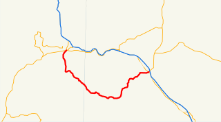
Oregon Route 66 is an Oregon state highway that runs between the cities of Ashland and Klamath Falls. The highway is known as the Green Springs Highway No. 21, and is signed east-to-west.

Oregon Route 138 is an Oregon state highway that runs between the city of Elkton and a junction with U.S. Route 97 at Diamond Lake Junction. The highway has several distinct stretches, and is the main east–west highway through Roseburg, and provides access to Crater Lake National Park from the north. The highway is signed east–west.
Oregon Route 230 is an Oregon state highway which runs along the western edge of Crater Lake National Park, in rural Douglas County, Oregon. It is known as the West Diamond Lake Highway No. 233, and is 24 miles (39 km) long.
Oregon Route 238 is an Oregon state highway which runs between the cities of Grants Pass, Oregon and Medford, Oregon, and through the historic town of Jacksonville. It is known as the Jacksonville Highway No. 272, and is 39 miles (63 km) long. It lies in Jackson and Josephine County.

New York State Route 179 (NY 179) is a short 4.40-mile (7.08 km) long state highway located south of Buffalo in Erie County, New York, in the United States. It is a four-lane divided road for most of its length. It is known as Mile Strip Road. A small section between U.S. Route 62 (US 62) and NY 5 in Blasdell, however, is a limited-access highway known as the Mile Strip Expressway. It connects to two major expressways, the New York State Thruway and the Southern Expressway (US 219), by way of interchanges. It serves as a connector road between them and three other major routes, NY 5, US 62, and US 20. Thus it is very busy not only at rush hours, but also after Buffalo Bills' home football games due to its proximity to Ralph Wilson Stadium.
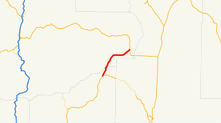
Oregon Route 422 (OR 422) is an Oregon state highway running from Modoc Point Road near Klamath Agency to US 97 near Chiloquin. OR 422 is known as the Chiloquin Highway No. 422. It is 5 miles (8.0 km) long and runs east–west, entirely within Klamath County.
Interstate 5 (I-5) in the U.S. state of Oregon is a major Interstate Highway that traverses the state from north to south. It travels to the west of the Cascade Mountains, connecting Portland to Salem, Eugene, Medford, and other major cities in the Willamette Valley and across the northern Siskiyou Mountains. The highway runs 308 miles (496 km) from the California state line near Ashland to the Washington state line in northern Portland, forming the central part of Interstate 5's route between Mexico and Canada.
There are 21 routes assigned to the "G" zone of the California Route Marker Program, which designates county routes in California. The "G" zone includes county highways in Monterey, San Benito, San Luis Obispo, Santa Clara, and Santa Cruz counties.

Train Mountain Railroad is a miniature hobbyist railroad near Chiloquin, Oregon, in Klamath County, which is in the south central region of Oregon. It is situated between Klamath Falls, Oregon, approximately 26 miles (42 km) to the south, and Crater Lake National Park to the north.

