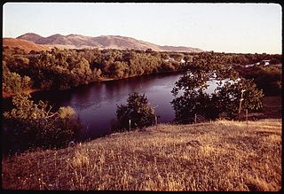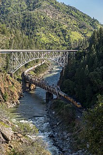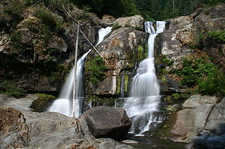
The Mojave River is an intermittent river in the eastern San Bernardino Mountains and the Mojave Desert in San Bernardino County, California, United States. Most of its flow is underground, while its surface channels remain dry most of the time, with the exception of the headwaters and several bedrock gorges in the lower reaches.

The Kings River is a 132.9-mile (213.9 km) river draining the Sierra Nevada mountain range in central California in the United States. Its headwaters originate along the Sierra Crest in and around Kings Canyon National Park and form the eponymous Kings Canyon, one of the deepest river gorges in North America. The river is impounded in Pine Flat Lake before flowing into the San Joaquin Valley southeast of Fresno. With its upper and middle course in Fresno County, the Kings River diverges into multiple branches in Kings County, with some water flowing south to the old Tulare Lake bed and the rest flowing north to the San Joaquin River. However, most of the water is consumed for irrigation well upstream of either point.

The Little Colorado River is a tributary of the Colorado River in the U.S. state of Arizona, providing the principal drainage from the Painted Desert region. Together with its major tributary, the Puerco River, it drains an area of about 26,500 square miles (69,000 km2) in eastern Arizona and western New Mexico. Although it stretches almost 340 miles (550 km), only the headwaters and the lowermost reaches flow year-round. Between St. Johns and Cameron, most of the river is a wide, braided wash, only containing water after heavy snowmelt or flash flooding.

The Merced River, in the central part of the U.S. state of California, is a 145-mile (233 km)-long tributary of the San Joaquin River flowing from the Sierra Nevada into the San Joaquin Valley. It is most well known for its swift and steep course through the southern part of Yosemite National Park, where it is the primary watercourse flowing through Yosemite Valley. The river's character changes dramatically once it reaches the plains of the agricultural San Joaquin Valley, where it becomes a slow-moving meandering stream.

The Humboldt River runs through northern Nevada in the western United States. At approximately 290 miles (470 km) long it is the third longest river in the Great Basin, after the Bear and Sevier Rivers. It has no outlet to the ocean, but instead empties into the Humboldt Sink. It is the fifth largest river in the United States, in terms of discharge, that does not ultimately reach the ocean, while it is the largest in terms of area drained. Through its tributaries the river drains most of sparsely populated northern Nevada, traversing the state roughly east to west, and passing through repeated gaps in the north-south running mountain ranges. It furnishes the only natural transportation artery across the Great Basin and has provided a route for historic westward migrations and subsequent railroads and highways. The river is named for the German naturalist Alexander von Humboldt.

The Feather River is the principal tributary of the Sacramento River, in the Sacramento Valley of Northern California. The river's main stem is about 73 miles (117 km) long. Its length to its most distant headwater tributary is just over 210 miles (340 km). The main stem Feather River begins in Lake Oroville, where its four long tributary forks join together—the South Fork, Middle Fork, North Fork, and West Branch Feather Rivers. These and other tributaries drain part of the northern Sierra Nevada, and the extreme southern Cascades, as well as a small portion of the Sacramento Valley. The total drainage basin is about 6,200 square miles (16,000 km2), with approximately 3,604 square miles (9,330 km2) above Lake Oroville.
The Santa Margarita River which with the addition of what is now Temecula Creek, was formerly known as the Temecula River, is a short intermittent river on the Pacific coast of southern California in the United States, approximately 30.9 miles (49.7 km) long. One of the last free-flowing rivers in southern California, it drains an arid region at the southern end of the Santa Ana Mountains, in the Peninsular Ranges between Los Angeles and San Diego.

The Navarro River is a 28.3-mile-long (45.5 km) river in Mendocino County, California, United States. It flows northwest through the Coastal Range to the Pacific Ocean. The main stem of the Navarro River begins less than 1 mile (2 km) south of the town of Philo at the confluence of Rancheria Creek and Anderson Creek. The mouth of the Navarro is 10 miles (16 km) south of the city of Mendocino. State Route 128 starts from the intersection of State Route 1 at the mouth of the Navarro River, and follows the river valley upstream to Philo. The river is close to the highway through the lower canyon but is some distance south of the highway as the Anderson Valley widens upstream of Wendling.

Cache Creek is an 87-mile-long (140 km) stream in Lake, Colusa and Yolo counties, California.

The San Jacinto River is a 42-mile-long (68 km) river in Riverside County, California. The river's headwaters are in San Bernardino National Forest, but the lower portion of the 765-square-mile (1,980 km2) watershed is urban and agricultural land. As a partially endorheic watershed that is contiguous with other Great Basin watersheds, the western side of the San Jacinto Basin is a portion of the Great Basin Divide.

Aliso Creek is a major tributary of the Upper Los Angeles River in the Santa Susana Mountains in Los Angeles County and western San Fernando Valley in the City of Los Angeles, California.

Salt Creek Falls is a cascade and plunge waterfall on Salt Creek, a tributary of the Middle Fork Willamette River, that plunges into a gaping canyon near Willamette Pass in the Willamette National Forest, near Oakridge, Oregon. The waterfall is notable for its main drop of 286 feet (87 m) which makes it the third highest plunge waterfall in Oregon after Multnomah Falls and Watson Falls the second highest, which was re-measured in 2009 and found to be 293 feet rather than an earlier measurement of 272 feet passing Salt Creek Falls. The pool at the bottom of the waterfall is 20 metres (66 ft) deep.

Arnold is an unincorporated community in Mendocino County, California. It is located on Outlet Creek adjacent to the Northwestern Pacific Railroad and U.S. Route 101 3 miles (4.8 km) southeast of Longvale, at an elevation of 1220 feet.

Longvale is an unincorporated community in Mendocino County, California. It is located on Outlet Creek adjacent to the Northwestern Pacific Railroad and U.S. Route 101 9.5 miles (15 km) south-southeast of Laytonville, at an elevation of 1191 feet.

The South Fork Coquille River is the longest tributary of the Coquille River in coastal Oregon in the United States. From its headwaters in the Southern Oregon Coast Range, the river flows northwest to join the North Fork Coquille River at Myrtle Point, forming the main stem Coquille. The South Fork is about 63 miles (101 km) long, and its watershed drains roughly 288 square miles (750 km2) of rural Coos County.

The Middle Fork Kings River is a 37.2-mile (59.9 km) tributary of the Kings River in Kings Canyon National Park, California, in the southern Sierra Nevada. Draining 318 square miles (820 km2) – almost all of it wilderness – the Middle Fork is one of the largest wholly undeveloped watersheds in the state, with no dams or paved roads within its basin. The entire length of the Middle Fork is designated a National Wild and Scenic River.

The Rice Fork is a 22.7-mile-long (36.5 km) tributary of the Eel River in Lake County, California. The Rice Fork begins on the upper northwest side of Goat Mountain, on the Colusa-Lake County line, at an elevation of over 6,000 feet (1,800 m). It quickly descends the steep western slope of the mountain, then bends northward, and flows northwesterly down a narrow winding steep walled canyon for about 18 miles (29 km), crossing two forest roads and adding many tributaries, ending its journey at the southern tip of Lake Pillsbury, at a varied elevation around 1,800 feet (550 m), depending on the lake level. Before the construction of Scott Dam in the 1920s, which formed Lake Pillsbury, the Rice Fork ran directly into the Eel River. It is one of Lake County's longest streams.

The Colorado River is a major river of the western United States and northwest Mexico in North America. Its headwaters are in the Rocky Mountains where La Poudre Pass Lake is its source. Located in north central Colorado it flows southwest through the Colorado Plateau country of western Colorado, southeastern Utah and northwestern Arizona where it flows through the Grand Canyon. It turns south near Las Vegas, Nevada, forming the Arizona–Nevada border in Lake Mead and the Arizona–California border a few miles below Davis Dam between Laughlin, Nevada and Needles, California California before entering Mexico in the Colorado Desert. Most of its waters are diverted into the Imperial Valley of Southern California. In Mexico its course forms the boundary between Sonora and Baja California before entering the Gulf of California. This article describes most of the major features along the river.

Little Rock Creek is a 16.7-mile (26.9 km) northwestward-flowing stream in the San Gabriel Mountains and Mojave Desert, within northern Los Angeles County, California.

Deep Creek is a tributary of the Mojave River, 23.4 miles (37.7 km) long, in San Bernardino County, California.


