Sequoiadendron giganteum is the sole living species in the genus Sequoiadendron, and one of three species of coniferous trees known as redwoods, classified in the family Cupressaceae in the subfamily Sequoioideae, together with Sequoia sempervirens and Metasequoia glyptostroboides. Giant sequoia specimens are the most massive trees on Earth. The common use of the name sequoia usually refers to Sequoiadendron giganteum, which occurs naturally only in groves on the western slopes of the Sierra Nevada mountain range of California.

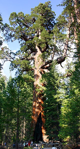
General Sherman is a giant sequoia tree located at an elevation of 2,109 m (6,919 ft) above sea level in the Giant Forest of Sequoia National Park in Tulare County, in the U.S. state of California. By volume, it is the largest known living single-stem tree on Earth. It is estimated to be around 2,200 to 2,700 years old.

Humboldt Redwoods State Park is a state park of California, United States, containing Rockefeller Forest, the world's largest remaining contiguous old-growth forest of coast redwoods. It is located 30 miles (48 km) south of Eureka, California, near Weott in southern Humboldt County, within Northern California, named after the great nineteenth-century scientist, Alexander von Humboldt. The park was established by the Save the Redwoods League in 1921 largely from lands purchased from the Pacific Lumber Company. Beginning with the dedication of the Raynal Bolling Memorial Grove, it has grown to become the third-largest park in the California State Park system, now containing 51,651 acres (20,902 ha) through acquisitions and gifts to the state.

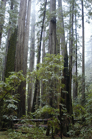
The Redwood National and State Parks (RNSP) are a complex of one national park and three state parks, cooperatively managed, located in the United States along the coast of northern California. Comprising Redwood National Park and California's State Parks: Del Norte Coast, Jedediah Smith, and Prairie Creek, the combined RNSP contain 139,000 acres (560 km2), and feature old-growth temperate rainforests. Located within Del Norte and Humboldt Counties, the four parks, protect 45 percent of all remaining coast redwood old-growth forests, totaling at least 38,982 acres (157.75 km2). These trees are the tallest, among the oldest, and one of the most massive tree species on Earth. In addition to the redwood forests, the parks preserve other indigenous flora, fauna, grassland prairie, cultural resources, waterways, and 37 miles (60 km) of pristine coastline.

The Eel River is a major river, about 196 miles (315 km) long, of northwestern California. The river and its tributaries form the third largest watershed entirely in California, draining a rugged area of 3,684 square miles (9,540 km2) in five counties. The river flows generally northward through the Coast Ranges west of the Sacramento Valley, emptying into the Pacific Ocean about 10 miles (16 km) downstream from Fortuna and just south of Humboldt Bay. The river provides groundwater recharge, recreation, and industrial, agricultural and municipal water supply.
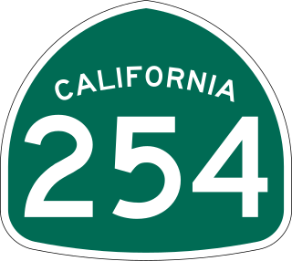
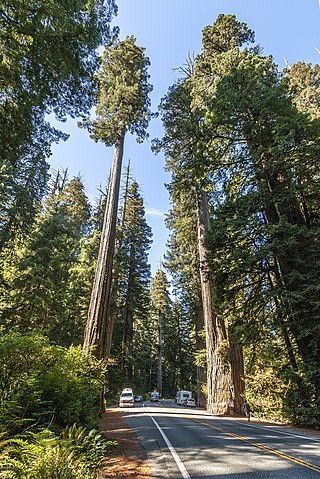
The Avenue of the Giants is a scenic highway in northern California, United States, running through Humboldt Redwoods State Park. It is named after the coastal redwoods that tower over the route. The road is a former alignment of U.S. Route 101, and continues to be maintained as a state highway as State Route 254.
The Northern California coastal forests are a temperate coniferous forests ecoregion of coastal Northern California and southwestern Oregon.
The Mendocino Range is one of several coastal mountain ranges which compose the Pacific Coast Range. This massive range of coastal mountains was formed during a period of coastal orogeny, millions of years ago. The Mendocino Range is a component of the California Coast Ranges of California. The Klamath Range is north of this region, and the Cascade Range runs to the northeast.

The Kaweah River is a river draining the southern Sierra Nevada in Tulare County, California in the United States. Fed primarily by high elevation snowmelt along the Great Western Divide, the Kaweah begins as four forks in Sequoia National Park, where the watershed is noted for its alpine scenery and its dense concentrations of giant sequoias, the largest trees on Earth. It then flows in a southwest direction to Lake Kaweah – the only major reservoir on the river – and into the San Joaquin Valley, where it diverges into multiple channels across an alluvial plain around Visalia. With its Middle Fork headwaters starting at almost 13,000 feet (4,000 m) above sea level, the river has a vertical drop of nearly two and a half miles (4.0 km) on its short run to the San Joaquin Valley, making it one of the steepest river drainages in the United States. Although the main stem of the Kaweah is only 33.6 miles (54.1 km) long, its total length including headwaters and lower branches is nearly 100 miles (160 km).
Redwood Creek is a 61.8-mile (99.5 km) river in Humboldt County, California. The river's headwaters are in the Coast Range at about 5,000 feet (1,500 m) and it flows roughly northwest until it empties into the Pacific Ocean near the small town of Orick, the only development in the 280-square-mile (730 km2)-watershed.

Save the Redwoods League is a nonprofit organization whose mission is to protect and restore coast redwood and giant sequoia trees through the preemptive purchase of development rights of notable areas with such forests.
Weott is a census-designated place in Humboldt County, California. It is located 233 miles (375 km) north of San Francisco, California and 25 miles (40 km) due east of the Pacific Ocean. Lower Weott is situated at an elevation of 330 feet (100 m) along the Avenue of the Giants and in the flood plain of the South Fork of the Eel River. The population was 288 at the 2010 census. Note that Weott is not related to Camp Weeott, a fishing village established about 1925 and destroyed in the 1955 flood which was located 37 miles (60 km) northwest of Weott, near Ferndale, California.

Converse Basin Grove is a grove of giant sequoia trees in the Giant Sequoia National Monument in the Sierra Nevada, in Fresno County, California, 5 miles (8 km) north of General Grant Grove, just outside Kings Canyon National Park. Once home to the second-largest population of giant sequoias in the world, covering 4,600 acres (19 km2) acres, the grove was extensively logged by the Sanger Lumber Company at the turn of the 20th century. The clearcutting of 8,000 giant sequoias, many of which were over 2,000 years old, resulted in the destruction of the old-growth forest ecosystem.

Iluvatar is a redwood tree in Prairie Creek Redwoods State Park in Northern California that has been confirmed to be at least 20.5 feet (6.2 m) in diameter at breast height, and 320 feet (98 m) in height. Measured by botanist Stephen C. Sillett, it is the world's third-largest coast redwood, the largest being Lost Monarch.

Michael W. Taylor is a leading discoverer of champion and tallest trees - most notably coast redwoods. In 2006, Taylor co-discovered the tallest known tree in the world, a coast redwood now named "Hyperion". He also discovered "Helios" and "Icarus", the 2nd and 3rd tallest.
Bull Creek is a locality 11 miles (18 km) south-southeast of Scotia, at an elevation of 7 feet (2.1 m) in Humboldt County, California. Bull Creek Road parallels Bull Creek and is also known as the Mattole Road.

The South Fork Eel River is the largest tributary of the Eel River in north-central California in the United States. The river flows 105 miles (169 km) north from Laytonville to Dyerville/Founders' Grove where it joins the Eel River. The South Fork drains a long and narrow portion of the Coast Range of California in parts of Mendocino and Humboldt counties. U.S. Route 101 follows the river for much of its length.
Sequoia sempervirens is the sole living species of the genus Sequoia in the cypress family Cupressaceae. Common names include coast redwood, coastal redwood, and California redwood. It is an evergreen, long-lived, monoecious tree living 1,200–2,200 years or more. This species includes the tallest living trees on Earth, reaching up to 115.9 m (380.1 ft) in height and up to 8.9 m (29 ft) in diameter at breast height. These trees are also among the longest-living organisms on Earth. Before commercial logging and clearing began by the 1850s, this massive tree occurred naturally in an estimated 810,000 ha along much of coastal California and the southwestern corner of coastal Oregon within the United States.

Bear River is the largest Pacific coastal drainage basin between the Mattole River and the Eel River. Bear River drains the ranch pastures and forests of California Coast Ranges south of the Bear River Ridge extending easterly from False Cape along the False Cape shear zone of the Russ Fault. The river channel through undivided Cretaceous marine formations exposes younger Neogene, namely middle or lower Pliocene, marine sedimentary and metasedimentary rocks near the mouth, but lacks the well defined offshore submarine canyons of the Eel River to the north and the Mattole River to the south. Bear River reaches the Pacific after flowing westerly approximately 20 miles (32 km) from elevations above 2,000 feet (600 m) along the ridge above the Bull Creek drainage of Humboldt Redwoods State Park. Bear River provides the recreational and industrial water supply for the community of Capetown, California, and wildlife habitat including cold freshwater habitat for fish migration and spawning.
