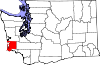
Pacific County is a county in the U.S. state of Washington. As of the 2020 census, the population was 23,365. Its county seat is South Bend, and its largest city is Raymond. The county was formed by the government of Oregon Territory in February 1851 and is named for the Pacific Ocean.

Clatsop County is one of the 36 counties in the U.S. state of Oregon. As of the 2020 census, the population was 41,072. The county seat is Astoria. The county is named for the Clatsop tribe of Native Americans, who lived along the coast of the Pacific Ocean prior to European settlement. Clatsop County comprises the Astoria, OR Micropolitan Statistical Area, or Sunset Empire, and is located in Northwest Oregon.
The Territory of Oregon was an organized incorporated territory of the United States that existed from August 14, 1848, until February 14, 1859, when the southwestern portion of the territory was admitted to the Union as the State of Oregon. Originally claimed by several countries, Spanish "El Orejón" was part of the Territorio de Nutca (1789–1795), later in the 19th century, the region was divided between the British Empire and the US in 1846. When established, the territory encompassed an area that included the current states of Oregon, Washington, and Idaho, as well as parts of Wyoming and Montana. The capital of the territory was first Oregon City, then Salem, followed briefly by Corvallis, then back to Salem, which became the state capital upon Oregon's admission to the Union.

The State of Deseret was a proposed state of the United States, promoted by leaders of the Church of Jesus Christ of Latter-day Saints who had founded settlements in what is today the state of Utah. A provisional state government operated for nearly two years in 1849–50, but was never recognized by the United States government. The name Deseret derives from the word for "honeybee" in the Book of Mormon.

The history of Washington includes thousands of years of Native American history before Europeans arrived and began to establish territorial claims. The region was part of Oregon Territory from 1848 to 1853, after which it was separated from Oregon and established as Washington Territory following the efforts at the Monticello Convention. On November 11, 1889, Washington became the 42nd state of the United States.

Cape Disappointment State Park is a public recreation area on Cape Disappointment, located southwest of Ilwaco, Washington, on the bottom end of Long Beach Peninsula, the northern headlands where the Columbia River meets the Pacific Ocean. The state park's 2,023 acres (819 ha) encompass a diverse landscape of old-growth forest, freshwater lakes, freshwater and saltwater marshes, and oceanside tidelands. Park sites include Fort Canby, the Lewis and Clark Interpretive Center, North Head Lighthouse, and Cape Disappointment Lighthouse. Cape Disappointment is one of several state parks and sites in Washington and Oregon that are included in Lewis and Clark National Historical Park.

George Law Curry was a predominant American political figure and newspaper publisher in the region that eventually became the state of Oregon. A native of Pennsylvania, he published a newspaper in St. Louis, Missouri, before traveling the Oregon Trail to the unorganized Oregon Country. A Democrat, Curry served in the new Oregon Territory's government as a representative to the legislature and as Territorial Secretary before appointment as the last Governor of the Oregon Territory. Curry County in Southern Oregon is named in his honor.

Peter Hardeman Burnett was an American politician who served as the first elected Governor of California from December 20, 1849, to January 9, 1851. Burnett was elected Governor almost one year before California's admission to the Union as the 31st state in September 1850.
Reuben Patrick Boise was an American attorney, judge and politician in the Oregon Territory and the early years of the state of Oregon. A native of Massachusetts, he immigrated to Oregon in 1850, where he would twice serve on the Oregon Supreme Court for a total of 16 years, with three stints as chief justice. Early in his legal career, he worked as a district attorney.

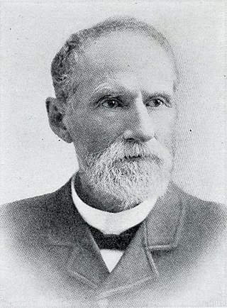
Peter Grant Stewart was a jeweler and pioneer of the Oregon Country in what later became the U.S. states of Oregon and Washington. A native of New York state, he traveled the Oregon Trail to the Willamette Valley and settled first in Oregon City and later in what became Washington. He was served on the Second Executive Committee of the Provisional Government of Oregon, and his homesite became part of Fort Canby at the mouth of the Columbia River.

Columbia Lancaster was an American lawyer and politician who served as the first Delegate from the Territory of Washington to the United States House of Representatives.
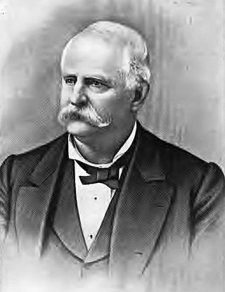
William Strong was an American attorney and jurist in the Pacific Northwest. He was the 4th justice of the Oregon Supreme Court when the region was still the Oregon Territory. A native of Vermont, he settled in the Washington Territory after it was created in 1853 and served in the legislature of that territory and on the Washington Supreme Court. Later he returned to Oregon and settled in Portland.

Oregon's Territorial Legislature was a bicameral legislative body created by the United States Congress in 1848 as the legislative branch of the government of the Oregon Territory. The upper chamber Council and lower chamber House of Representatives first met in July 1849; they served as the region's legislative body until Oregon became a state in February 1859, when they were replaced by the bicameral Oregon State Legislature.
Washington, officially the State of Washington, is a state in the Pacific Northwest region of the United States. It is often referred to as Washington state or Washington State to distinguish it from the national capital, both named for George Washington. Washington borders the Pacific Ocean to the west, Oregon to the south, Idaho to the east, and the Canadian province of British Columbia to the north. The state was formed from the western part of the Washington Territory, which was ceded by the British Empire in the Oregon Treaty of 1846. It was admitted to the Union as the 42nd state in 1889. Olympia is the state capital, and the most populous city is Seattle.

William Pope McArthur was an American naval officer and hydrologist who was involved in the first surveys of the Pacific Coast for the United States Coast Survey.

Pinkney City was a small community outside of Fort Colville in what is now Stevens County, Washington. Originally named for Brevet Major Pinkney Lugenbeel, first commander and builder of the fort in 1859. The town grew up around the fort shortly after.
James Urquhart served three terms in the Washington Territory legislature. He was also elected to three terms as a county commissioner in Lewis County, Washington. He was a delegate to the Washington State Constitutional Convention. In 1873, he laid out the town of Napavine where he was Postmaster and ran the general store. He chose the town's name from the Indian word "napavoon" meaning small prairie.

The role of Washington Territory in the American Civil War is atypical, as the territory was the most remote from the main battlefields of the conflict. The territory raised a small number of volunteers for the Union Army, who did not fight against the Confederate States Army but instead maintained defensive positions against possible foreign naval or land attacks. Although the Indian Wars in Washington were recent, there were no Indian hostilities within the area of modern Washington, unlike the rest of the western states and territories, during the Civil War. At the start of the American Civil War, modern-day Washington was part of the Washington Territory. On March 3, 1863, the Idaho Territory was formed from that territory, consisting of the entirety of modern-day Idaho, Montana, and all but southwest Wyoming, leaving the modern-day Washington as Washington Territory.

"General" Morton Matthew McCarver was an American politician and pioneer in the West. A native of Kentucky, he helped found cities in Iowa, Oregon, and Washington while also involved in the early government of California. He served in the Provisional Legislature of Oregon, including as the first speaker of that body, and also fought in the Rogue River Wars.
William Myron King, also known as Colonel King for most of his life, was an American pioneer merchant and Oregon state legislator. He served four terms in Oregon's territorial legislature. This included one term as Speaker of the Oregon House of Representatives during the 1851 legislative session. Before immigrating to Oregon, King lived and worked in New York, Pennsylvania, Ohio, and Missouri. After moving to Oregon in 1848, he became a merchant in Portland, and was later the county judge for Multnomah County and a member of Portland's city council.