Willapa, Washington

Last updated

Willapa, Washington
CDP
USA Washington location map.svg
Red pog.svg
Willapa, Washington
Location in the state of Washington
Coordinates: 46°41′N123°40′W / 46.683°N 123.667°W / 46.683; -123.667
Country United States
State Washington
County Pacific
Area
[1]
  Total0.278 sq mi (0.720 km2)
  Land0.278 sq mi (0.720 km2)
  Water0.000 sq mi (0.000 km2)  0.00%
Elevation
[2]
30 ft (9 m)
Population
 (2010) [3]
  Total210 [3]
 Population as of 2010 U.S. Census
Time zone UTC−8 (PST)
  Summer (DST) UTC−7 (PDT)
ZIP code
98577
Area code 360
FIPS code 53-78995
GNIS feature ID2586751 [4]

Willapa is a census-designated place (CDP) in Pacific County, Washington, east of the city of Raymond. The population was 210 as of the 2010 census. The name comes from that of the Willapa people, an Athapaskan-speaking people, now extinct, who occupied the Willapa River valley, which was similarly named after the Willapa people, along which the census-designated place Willapa is located. [5]

Contents

Geography

Willapa is located at 46°40′32″N123°39′53″W / 46.67556°N 123.66472°W / 46.67556; -123.66472 (46.6754474, -123.6647525). [1]

According to the United States Census Bureau, the CDP has a total area of 0.28 square miles (0.73 km2), of which all of it (100.0%) is land and none of it (0.0%) is water.

Demographics

Historical population
CensusPop.Note
2010 210
2010 U.S. Census

As of the census of 2010, [3] there were 210 people, 81 households, and 62 families residing in the CDP. The population density was 755.4 people per square mile (291.7 people/km2). There were 88 housing units at an average density of 316.5 per square mile (122.2/km2). The racial makeup of the CDP was 95.7% White, 0.0% African American, 2.9% Native American, 0.0% Asian, 0.0% Pacific Islander, 0.0% from other races, and 1.4% from two or more races. Hispanic or Latino of any race were 2.9% of the population.

There were 81 households, out of which 32.1% had children under the age of 18 living with them, 65.4% were married couples living together, 7.4% had a female householder with no husband present, and 23.5% were non-families. 19.8% of all households were made up of individuals, and 27.2% had someone living alone who was 65 years of age or older. The average household size was 2.59 and the average family size was 2.90.

In the CDP, the age distribution of the population shows 24.3% under the age of 18, 5.2% from 18 to 24, 19.0% from 25 to 44, 39.0% from 45 to 64, and 12.4% who were 65 years of age or older. The median age was 45.5 years. For every 100 females, there were 92.7 males. For every 100 females age 18 and over, there were 96.3 males.

Related Research Articles

<span class="mw-page-title-main">Pacific County, Washington</span> County in Washington, United States

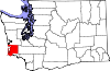
Pacific County is a county in the U.S. state of Washington. As of the 2020 census, the population was 23,365. Its county seat is South Bend, and its largest city is Raymond. The county was formed by the government of Oregon Territory in February 1851 and is named for the Pacific Ocean.

<span class="mw-page-title-main">Auberry, California</span> Census-designated place in California, United States

Auberry is a census-designated place (CDP) in Fresno County, California, United States. The population was 2,369 at the 2010 census, up from 2,053 at the 2000 census. Auberry is located on Little Sandy Creek 9.5 miles (15 km) west of Shaver Lake Heights, at an elevation of 2,018 feet (615 m).

<span class="mw-page-title-main">Raisin City, California</span> Census-designated place in California, United States

Raisin City is a census-designated place (CDP) in Fresno County, California, United States. The population was 380 at the 2010 census, up from 165 at the 2000 census. Raisin City is located 13 miles (21 km) south-southwest of downtown Fresno, at an elevation of 236 feet.

<span class="mw-page-title-main">Mineral, California</span> Census designated place in California, United States

Mineral is a boundaried but unincorporated forest village in Tehama County, California, United States. It has been part of a much larger census-designated place since 1980, for which the population was 123 at the 2010 census, down from 143 at the 2000 census.

<span class="mw-page-title-main">Boyette, Florida</span> Former CDP in Florida, United States

Boyette is an unincorporated community and former census-designated place in Hillsborough County, Florida, United States. The population was 5,895 at the 2000 census. The CDP area merged with Riverview in 2010.

<span class="mw-page-title-main">Buckner, Kentucky</span> CDP in Kentucky, United States

Buckner is a census-designated place (CDP) in Oldham County, Kentucky, United States. The population was 4,000 at the 2000 census.

<span class="mw-page-title-main">Hayward, Missouri</span> Census-designated place in Missouri, United States

Hayward is a census-designated place and former village in Pemiscot County, Missouri, United States. The population was 131 at the 2010 census.

<span class="mw-page-title-main">Macy, Nebraska</span> Census-designated place in Thurston County, Nebraska, United States

Macy is a census-designated place (CDP) in Thurston County, Nebraska, United States. The population was 1,045 at the 2020 census. It is within the Omaha Reservation, and includes Omaha Nation Public Schools.

<span class="mw-page-title-main">Yorketown, New Jersey</span> Populated place in Monmouth County, New Jersey, US

Yorketown is an unincorporated community and census-designated place (CDP) within Manalapan Township, in Monmouth County, in the U.S. state of New Jersey. At the 2020 census, the CDP's population was 6,739.

<span class="mw-page-title-main">Montrose-Ghent, Ohio</span> CDP in Ohio, United States

Montrose-Ghent is a census-designated place (CDP) in Summit County, Ohio, United States, composed of the unincorporated communities of Montrose and Ghent. The population was 5,254 at the 2020 census. It is part of the Akron Metropolitan Statistical Area.

<span class="mw-page-title-main">Pine Glen, Pennsylvania</span> Census-designated place in Pennsylvania, United States

Pine Glen is an unincorporated community and census-designated place (CDP) in Centre County, Pennsylvania, United States. It is part of the State College, Pennsylvania Metropolitan Statistical Area. It is part of Burnside Township. The population was 190 at the 2010 census.

<span class="mw-page-title-main">Edroy, Texas</span> CDP in Texas, United States

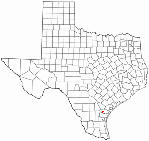
Edroy is a census-designated place (CDP) in San Patricio County, Texas, United States. The population was 422 at the 2020 census.

<span class="mw-page-title-main">Central Park, Washington</span> CDP in Washington, United States

Central Park is a census-designated place (CDP) in Grays Harbor County, Washington, United States. The population was 2,841 at the 2020 census.

<span class="mw-page-title-main">Chehalis Village, Washington</span> Former CDP in Washington, United States

Chehalis Village is a former census-designated place (CDP) in Grays Harbor County, Washington, United States. The population was 346 at the 2000 census. The area was no longer listed as a CDP for the 2010 census.

<span class="mw-page-title-main">Junction City, Washington</span> Census-designated place in Washington, United States

Junction City is a census-designated place (CDP) in Grays Harbor County, Washington, United States. The population was 18 at the 2010 census.

<span class="mw-page-title-main">Markham, Washington</span> CDP in Washington, United States

Markham is a census-designated place (CDP) in Grays Harbor County, Washington, United States. The population was 119 at the 2020 census.

<span class="mw-page-title-main">Bay Center, Washington</span> CDP in Washington, United States

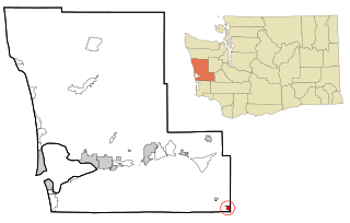
Bay Center is a census-designated place (CDP) in Pacific County, Washington, United States. The population was 174 at the 2000 census. The population increased to 276 at the 2010 census. However, in the 2020 census, the population decreased to 253.

<span class="mw-page-title-main">Naselle, Washington</span> Place in Washington, United States

Naselle is a census-designated place (CDP) in Pacific County, Washington, United States located about 23 miles (37 km) from the mouth of the Columbia River. The population was 421 at the 2020 census. The valley's Naselle River flows west into nearby Willapa Bay and then into the Pacific Ocean. Close about the town lie the evergreen-covered Willapa Hills. The river's name has been spelled Nasel and Nasal. An early settler along the river called it the Kenebec. The name comes from the Nisal Indians, a Chinookan tribe formerly residing on the river.

<span class="mw-page-title-main">South Bend, Washington</span> City in Washington, United States

South Bend is a city in and the county seat of Pacific County, Washington, United States. The population was 1,746 as of the 2020 census. The town is widely-known for its oyster production and scenery.

Clear Lake is a census-designated place (CDP) in Pierce County, Washington, north of the town of Eatonville. The population was 1,419 as of the 2010 census. The name comes from that of the lake of the same name located in the middle of the census-designated place.

References

  1. 1 2 "2013 U.S. Gazetteer Files". census.gov. Retrieved June 5, 2014.
  2. "USGS—Willapa, Washington" . Retrieved June 5, 2014.
  3. 1 2 3 "U.S. Census website". United States Census Bureau. 2011. Retrieved June 5, 2014.
  4. "Willapa Census Designated Place". Geographic Names Information System . United States Geological Survey, United States Department of the Interior.
  5. Curtis, Edward S. The North American Indian. Volume 9 - The Salishan tribes of the coast. The Chimakum and the Quilliute. The Willapa. Classic Books Company. pp. 141–142. ISBN   978-0-7426-9809-3.