Palisade Avenue (Hudson Palisades)

Last updated

Palisade Avenue

Palisade Avenue (Hudson Palisades)
Palisade Avenue highlighted in red
Route information
Component
highways
Hudson County section
South end Newark Avenue (CR 639)
Major intersections
North end79th Street
Bergen County section
South end John F. Kennedy Boulevard East (CR 693)
Major intersections
North endI-95.svgUS 1-9.svgUS 46.svg I-95  / US 1-9  / US 46 (George Washington Bridge Plaza)
Location
Country United States
State New Jersey
Highway system
Riverview-Fiske Park RiverviewFisk.jpg
Riverview-Fiske Park
The intersection at Main Post Office and Liberty Plaza in Union City is a major bus stop, with thousands of boardings daily. 8.7.09LibertyPlazaByLuigiNovi6.jpg
The intersection at Main Post Office and Liberty Plaza in Union City is a major bus stop, with thousands of boardings daily.
Union City City Hall 11.22.10UnionCityCityHallByLuigiNovi.jpg
Union City City Hall
North Hudson Park North Hudson Park arch jeh.JPG
North Hudson Park
Cliffside Park High School Cliffside Pk HS fall jeh.JPG
Cliffside Park High School

Palisade Avenue is the name given to a historic road which parallels the eastern crest of Hudson Palisades in northeastern New Jersey. It travels between Jersey City and Fort Lee, [1] passing through Jersey City Heights, North Hudson, and Cliffside Park, with various parts carrying Hudson and Bergen county route designations. [2] [3] [4] [5] The avenue re-aligns itself at several places along its route as it crosses traditional municipal boundaries created in the 19th century. As a primary route running along the top of the Hudson Palisades, many segments offer scenic views of the Hudson River and the New York skyline. Since 2020 there is proposed state legislation to restrict building heights that would rise above the cliffs on the eastern side of Palisade Avenue along the entire corridor from Jersey City to Fort Lee. [6] [7] [1] [8]

Contents

Route description

The southern end of Palisade Avenue begins at Newark Avenue, just east of the Hudson County Courthouse, running between the historic Jersey City High School and the 1942 Hudson Gardens Housing project. [9] It soon crosses over Bergen Arches and Long Dock Tunnel, (both of which served the Erie Railroad's Pavonia Terminal) and the Divided Highway (connecting the Pulaski Skyway and the Holland Tunnel). [10] At this point, the avenue enters Jersey City Heights and passes Christ Hospital. [11]

Upon crossing over a steep natural ravine and a road descending to Hoboken, Palisade Avenue intersects with Ferry Street, likely so named for the connection made possible by the North Hudson County Railway's Wagon Lift and Elevated (the latter used by the Public Service Railway and dismantled in 1947) which transported passengers up and down the cliffs. Two historic office buildings, one formerly PSE&G, and another now used North Hudson Community Action Group [12] are at the intersection, [13] at the end of which is Pohlmann's Hall. [14]

Proceeding north it runs alongside Riverview Park and the top of Holland Street [15] (a former carriage road and one of the few cobbled streets left in Hudson County) connecting to Paterson Plank Road. At 524 is the Van Vorst House a stone farmhouse built in 1742 by the family Van Vorst and considered to be the second oldest standing building in Hudson County. [16] At Congress Street the 9th Street-Congress Street Station of the Hudson Bergen Light Rail is one block to the east connected by an elevator to platforms at the base of the cliff.

Paterson Plank Road, which traverses Washington Park, creates the border between Jersey City and Union City, the southern part of which was at one time called West Hoboken. A Yardley Soap factory recalls the city's manufacturing past. [17] Nearby Firefighters Memorial Park. [18] was built partially as memorial to the September 11 attacks.

As the route passes the Hackensack Water Company Reservoir #2 it creates a border between Union City and Weehawken Heights, passing Ellsworth Park and Shippen Street, until it reaches Lincoln Tunnel Approach, a cut built in conjunction with the tunnel. The Main Post Office at the intersection with marginal road of 495 is a major stop for east-bound buses travelling to Manhattan.

After crossing over the highway and Hackensack Plank Road and entering the northern part of Union City formerly known as Union Hill, the avenue becomes a one lane, one-way street traveling southbound. Union City Town Hall is between 37th and 38th Streets. Just south of the border with West New York at 49th Street the avenue makes an S curve and continues as a one-way southbound street through the municipality. This segment of the route approaches the highest point in Hudson County, New Jersey at 260 feet. [19]

In Guttenberg the avenue once again realigns to the west and becomes a two-way street which continues through the Woodcliff Section of North Bergen, where it meets North Hudson-James J. Braddock Park. The avenue resumes inside the park at Boulevard East, traveling a short distance before crossing the Hudson-Bergen county line, entering Cliffside Park. Taking a more meandering course, the route passes the Cliffside Park Municipal Complex, [20] Cliffside Park Public Library [21] and Cliffside Park High School, then intersects with Gorge Road, one of the few roads along the face of the Hudson Palisades to low-lying areas along the Hudson River waterfront, in this case in Edgewater.

At the northern end of the borough the avenue passes the former site of Palisades Amusement Park, demolished in the 1970s for the construction of high-rise residential complexes. [22] [23] Soon after crossing over the Fort Lee line, Palisade diverges at triangle with Lemoine Avenue, and passes Fort Lee Museum and Monument Park. [24] [25] [26] After crossing Main Street, at the Barrymore Film Center, it passes the Modern higrise complex and ends at GWB Plaza, just west of Palisades Interstate Park and the George Washington Bridge.

See also

Related Research Articles

<span class="mw-page-title-main">New Jersey Route 5</span> State highway in Bergen County, New Jersey, US

Route 5 is a 3.18-mile (5.12 km) state highway located entirely in Bergen County, New Jersey, United States. It runs from U.S. Route 1/9 (US 1-9) in Ridgefield east down the New Jersey Palisades to end at County Route 505 at the Hudson River in Edgewater, forming a “wavy” path. The route is a two- to four-lane undivided highway its entire length, passing mostly through wooded residential neighborhoods. The route passes under Route 63 in Palisades Park, with access to that route provided by Bergen Boulevard, and intersects the southern terminus of Route 67 in Fort Lee.

<span class="mw-page-title-main">New Jersey Route 67</span> State highway in Bergen County, New Jersey, US

Route 67 is a short state highway entirely within the community of Fort Lee in Bergen County, New Jersey. It is part of the original alignment of U.S. Route 9W (US 9W). The road runs 1.86 miles (2.99 km) from an intersection with Central Boulevard in Fort Lee up Palisade Avenue in downtown Fort Lee. There it becomes known as Lemoine Avenue, terminating at an interchange with US 9W, the Palisades Interstate Parkway and Route 445S in Fort Lee. The route was designated originally as a portion of State Highway Route 18N in 1923, and was split up in 1929 as part of present-day Route 63, US 9W and Route 67 for Routes S-1, 1 and Route S1A. Route S-1-A remained intact on Palisades and Lemoine Avenue until the 1953 state highway renumbering when it was switched over to Route 67. The route has remained virtually intact since.

<span class="mw-page-title-main">Palisades Interstate Parkway</span> United States historic place

The Palisades Interstate Parkway (PIP) is a 38.25-mile (61.56 km) controlled-access parkway in the U.S. states of New Jersey and New York. The parkway is a major commuter route into New York City from Rockland and Orange counties in New York and Bergen County in New Jersey. The southern terminus of the route is at the George Washington Bridge in Fort Lee, New Jersey, where it connects to Interstate 95 (I-95), US 1-9, and US 46. Its northern terminus is at a traffic circle in Fort Montgomery, New York, where the PIP meets US 9W and US 202 at the Bear Mountain Bridge. At exit 18, the PIP forms a concurrency with US 6 for the remaining duration of its run.

<span class="mw-page-title-main">U.S. Route 9W</span> U.S. Numbered Highway in New York/New Jersey

U.S. Route 9W (US 9W) is a north–south United States Numbered Highway in the states of New Jersey and New York. It begins in Fort Lee, New Jersey, as Fletcher Avenue crosses the US 1/9, US 46, and Interstate 95 (I-95) approaches to the George Washington Bridge, and heads north up the west side of the Hudson River to US 9 in Albany, New York. As its "W" suffix indicates, US 9W is a westerly alternate route of US 9 between the two locations. US 9W directly serves three cities—Newburgh, Kingston, and Albany—and enters the vicinity of several others. As the route heads north, it connects to several highways of regional importance, including I-84, US 209, New York State Route 23 (NY 23), and US 20. Much of US 9W parallels the New York State Thruway and NY 32; additionally, the latter overlaps with US 9W in four different locations.

<span class="mw-page-title-main">New Jersey Route 18N</span> Former state highway in New Jersey, United States

Route 18N was a state highway in New Jersey from 1923 to 1929, when it was renumbered as Route 1 and Route S1A. Route 18-N was defined in 1923 to run "from Hoboken to New York State line by way of Weehawken, West Hoboken, town of Union, North Bergen, Fairview, Ridgefield, Palisade Park, Fort Lee, Englewood-Cliffs, Tenafly and Alpine." The part from Hoboken to Fort Lee was not built or taken over as Route 18-N; it seems to follow the old Bergen Turnpike to Ridgefield and then Route 5 east. Route 18-N's south end was at pre-1927 Route 10, now Route 5.

Paterson Plank Road is a road that runs through Passaic, Bergen and Hudson Counties in northeastern New Jersey. The route, originally laid in the colonial era, connects the city of Paterson and the Hudson River waterfront. It has largely been superseded by Route 3, but in the many towns it passes it has remained an important local thoroughfare, and in some cases been renamed.

<span class="mw-page-title-main">The Heights, Jersey City</span> District of Jersey City, New Jersey, United States

The Heights or Jersey City Heights is a neighborhood in Jersey City, New Jersey, located atop the New Jersey Palisades, along the west side of the Hudson River. It is bound by Paterson Plank Road on the north, Highway 139 on the south, Hoboken on the east, and the Hackensack River on the west. and Penhorn Creek on the west. Its postal area ZIP Codes are 07307, and portions of 07306.

<span class="mw-page-title-main">County Route 501 (New Jersey)</span> Highway in New Jersey

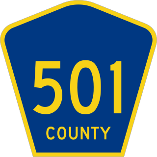
County Route 501 is a county highway in New Jersey in two segments spanning Middlesex, Hudson, and Bergen counties. The southern section runs from South Plainfield to Perth Amboy, the northern section runs from Bayonne to Rockleigh, and the two sections are connected by New York State Route 440 across Staten Island.

<span class="mw-page-title-main">County Route 505 (New Jersey)</span> County highway in New Jersey, U.S.

County Route 505 is a county highway in the U.S. state of New Jersey. The highway extends 20.64 miles from John F. Kennedy Boulevard in Union City to the New York state line in Northvale.

<span class="mw-page-title-main">Hackensack Plank Road</span>

The Hackensack Plank Road, also known as Bergen Turnpike, was a major artery which connected the cities of Hoboken and Hackensack, New Jersey. Like its cousin routes, the Newark Plank Road and Paterson Plank Road, it travelled over Bergen Hill and across the Hackensack Meadows from the Hudson River waterfront to the city for which it was named. It was originally built as a colonial turnpike road as Hackensack and Hoboken Turnpike. The route mostly still exists today, though some segments are now called the Bergen Turnpike. It was during the 19th century that plank roads were developed, often by private companies which charged a toll. As the name suggests, wooden boards were laid on a roadbed in order to prevent horse-drawn carriages and wagons from sinking into softer ground on the portions of the road that passed through wetlands. The company that built the road received its charter on November 30, 1802. The road followed the route road from Hackensack to Communipaw that was described in 1679 as a "fine broad wagon-road."

The 181 Union City-New York is a bus route operated by New Jersey Transit in the U.S. states of New Jersey and New York. Buses head north from the Bergenline Avenue Hudson-Bergen Light Rail station in Union City along Bergenline Avenue, Woodcliff Avenue, and Palisade Avenue to Fort Lee via West New York, Guttenberg, North Bergen, Fairview, and Cliffside Park, and cross the George Washington Bridge to the George Washington Bridge Bus Station in Upper Manhattan.

<span class="mw-page-title-main">Hudson Waterfront</span> Place in Hudson and Bergen

The Hudson Waterfront is an urban area of northeastern New Jersey along the lower reaches of the Hudson River, the Upper New York Bay and the Kill van Kull. Though the term can specifically mean the shoreline, it is often used to mean the contiguous urban area between the Bayonne Bridge and the George Washington Bridge that is approximately 19 miles (31 km) long. Historically, the region has been known as Bergen Neck, the lower peninsula, and Bergen Hill, lower Hudson Palisades. It has sometimes been called the Gold Coast.

<span class="mw-page-title-main">Bulls Ferry</span> Populated place in Hudson County, New Jersey, US

Bulls Ferry is an area along the Hudson River, just north of Weehawken Port Imperial in the towns of West New York, Guttenberg and North Bergen in New Jersey. It takes its name from a pre-Revolutionary settlement belonging to the Bull family, who operated a row-and-sail ferry to the burgeoning city of New York across the river.

<span class="mw-page-title-main">Summit Avenue (Hudson Palisades)</span> Road in Hudson County, New Jersey, US

County Route 617 is 4.55-mile (7.32 km) long and follows one street, Summit Avenue along the ridge of the Hudson Palisades in Hudson County, New Jersey. Its southern end is CR 622, or Grand Street, at Communipaw Junction in the Bergen-Lafayette Section of Jersey City. Its northern end is CR 691, 32nd Street, a section of the Bergen Turnpike, in Union City.

<span class="mw-page-title-main">Central Avenue (Hudson Palisades)</span> Populated place in Hudson County, New Jersey, US

Central Avenue is a 12-block-long thoroughfare in the Heights neighborhood of Jersey City, New Jersey, United States. One of 13 shopping districts in the city, it is designated County Route 663 for 1.60-mile (2.57 km) of its length. It originates at the intersection of Summit Avenue and Pavonia Avenue, and runs north, intersecting Newark Avenue one block east of Five Corners to Paterson Plank Road near Transfer Station. The avenue continues north through Union City without the county route designation to 35th Street, two blocks north of Hackensack Plank Road.

<span class="mw-page-title-main">Boulevard East</span> County road in New Jersey, U.S.

Boulevard East is a two-way, mostly two lane, scenic county road in the North Hudson, New Jersey municipalities of Weehawken, West New York, Guttenberg and North Bergen. Apart from small sections at either end, the road runs along the crest of the Hudson Palisades, affording it views of the Hudson River and the New York City skyline. Developed at the turn of the 20th century, the residential road is characterized by an eclectic mix of 20th-century architecture, including private homes as well as mid and high-rise apartment buildings, mostly on its western side, with a promenade and parks along its eastern side. It is also the setting for Edward Hopper's 1934 painting East Wind Over Weehawken, which is considered one of his best works.

<span class="mw-page-title-main">New Jersey Route 63</span> State highway in New Jersey, US

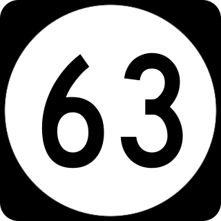
Route 63 is a short, 3.09-mile (4.97 km) long state highway in Hudson and Bergen counties in New Jersey. The route is known as Bergen Boulevard and concurrent with County Route 501 for most of its alignment. The southern terminus is at Kennedy Boulevard and County Route 501 in North Bergen. The route crosses the county line and heads along the boulevard through the communities of Ridgefield, Palisades Park, and Fort Lee before reaching its northern terminus at an interchange with U.S. Route 1-9 and 46 in Fort Lee.

<span class="mw-page-title-main">Nungessers</span> Junction in Bergen and Hudson counties, New Jersey, US

Nungessers is the name of the confluence of roads that meet at the Hudson and Bergen county line at North Bergen and Fairview in northeastern New Jersey. The area is the former site of the Nungesser's Gutenberg Racetrack, a late 19th-century gaming and gambling venue. The neighborhood just south of Nungesser's is called the Racetrack Section and the municipality of Guttenberg is nearby. A White Castle, an early drive-in fast-food chain, originally built in the 1930s has long been a landmark in the neighborhood, as has adjacent North Hudson Park.

<span class="mw-page-title-main">George Washington Bridge Plaza</span> Toll plaza in Fort Lee, New Jersey, US

The George Washington Bridge Plaza, also known as GWB Plaza or Bridge Plaza, is the convergence of roads and highways around the George Washington Bridge toll plaza in Fort Lee, New Jersey, United States. The plaza is located north of and parallel to Fort Lee's Main Street. The surrounding busy area is characterized by a mix of commercial and residential uses and an architectural variety that includes parking lots, strip malls, houses, gas stations, mid-rise office buildings and high-rise condominiums. Just to the east is Fort Lee Historic Park, Palisades Interstate Park and the bridge's western tower.

The Route 9 - Coytesville was a former streetcar line in Bergen County, New Jersey. Operated by the Palisades Railroad, a subsidiary of the North Hudson County Railway, the line ran from Coytesville in the north to Palisades Junction on the border of Fort Lee and Cliffside Park, and then split into two branches, one running to Edgewater and its ferry terminal, and one running to Weehawken Terminal. It opened sometime before 1895 and closed on June 1, 1933, although tracks remained until 1937.

References

  1. 1 2 Baer, Marilyn (January 8, 2021). "Hoboken council opposes Palisades Cliffs Protection Act". Hudson Reporter. Archived from the original on January 8, 2021.
  2. "Hudson County 685 straight line diagram" (PDF). New Jersey Department of Transportation. Archived from the original (PDF) on 2012-10-18. Retrieved 2010-01-14.
  3. "Hudson County 719 straight line diagram" (PDF). New Jersey Department of Transportation. Archived (PDF) from the original on 2012-10-18. Retrieved 2010-01-14.
  4. Bergen County Road 27 Archived 2012-10-18 at the Wayback Machine Straight Line Diagram from the New Jersey Department of Transportation
  5. "Route 67 straight line diagram" (PDF). Trenton, New Jersey: New Jersey Department of Transportation. Archived (PDF) from the original on June 4, 2011. Retrieved November 13, 2009.
  6. "Archived copy" (PDF). Archived (PDF) from the original on 2023-06-17. Retrieved 2023-08-12.{{cite web}}: CS1 maint: archived copy as title (link)
  7. D'Auria, Peter (December 27, 2020). "A state bill would protect the views from the Palisades cliffs, but will it change development in Hudson, Bergen counties?". The Jersey Journal. Archived from the original on June 15, 2023. Retrieved August 12, 2023.
  8. Fry, Chris (December 22, 2020). "Proposed Law Would Limit Building Height Along N.J.'s Hudson Waterfront". Archived from the original on June 19, 2023. Retrieved August 12, 2023.
  9. "Hudson Gardens". Archived from the original on 2009-06-22. Retrieved 2010-02-16.
  10. "DOT moving on to next Jersey City bridge replacement project". 10 September 2016. Archived from the original on 5 March 2017. Retrieved 20 September 2016.
  11. Hospital website
  12. North Hudson Community Action Group Archived 2010-04-28 at the Wayback Machine
  13. French, Kenneth (1997). Jersey City 1940-1960: The Dan McNulty Collection. Arcadia Publishing. p. 59. ISBN   978-0-7385-3731-3.
  14. "Pohlmann Hall". Archived from the original on 2011-07-15. Retrieved 2010-02-18.
  15. "JC Landmarks Commission". Archived from the original on 2009-11-27. Retrieved 2010-02-17.
  16. "Van Vorst House in Bergen Woods". Archived from the original on 2010-03-04. Retrieved 2010-02-16.
  17. "Wikimapia:Yardley soap Building". Archived from the original on 2020-05-16. Retrieved 2010-02-16.
  18. Rappaport, Melissa. "Now open: Firefighters Memorial Park" The Union City Reporter; August 16, 2009; Pages 1 & 8
  19. "Hudson High Point". Archived from the original on 2010-02-15. Retrieved 2010-02-16.
  20. Cliffside Park Archived 2010-01-23 at the Wayback Machine
  21. "Cliffside Park Public Library". Archived from the original on 2014-08-04. Retrieved 2010-02-16.
  22. Fowler, Glenn (January 20, 1971). "Palisades Park Expected To Close After Season". New York Times . Archived from the original on 2012-10-19. Retrieved 2009-01-27. Palisades Amusement Park, one of the last of the playgrounds that once dotted the outer reaches of the city and the nearby suburbs, may close after the 1971 season.
  23. "Carousel, Anyone? A 1928 'Heirloom' Offered for $80,000". New York Times . November 15, 1971. Archived from the original on 2012-10-19. Retrieved 2009-01-27. Irving Rosenthal has the Christmas present for the man who has everything. Preferably a man in search of high camp or deep nostalgia. ... Mr. Rosenthal sold the Palisades Amusement Park site to tho Centex-Winston Corporation, which plans to erect 3800 high-rise condominiums on the tract ...
  24. Fort Lee Monument Park Archived 2008-12-03 at the Wayback Machine
  25. Fort Lee Museum Archived 2010-01-12 at the Wayback Machine
  26. "Wikimapia: Fort Lee". Archived from the original on 2015-01-29. Retrieved 2010-02-16.