San Francisco International Airport is an international airport in an unincorporated area of San Mateo County, 13 miles (21 km) south of Downtown San Francisco. It has flights to points throughout North America and is a major gateway to Europe, the Middle East, Asia, and Oceania.

San Carlos Airport is two miles northeast of San Carlos, California, in San Mateo County, California. The FAA's National Plan of Integrated Airport Systems (NPIAS) classifies San Carlos as a reliever airport for San Francisco International Airport.

Peter O. Knight Airport is an airport on Davis Islands, five minutes from downtown Tampa, Florida. Built as a Works Progress Administration project, it was Tampa's main airport from 1935 to 1945, and is still used by general aviation operators today because of its proximity to the central city. The airport was named for prominent attorney and businessman Peter O. Knight, namesake of Holland & Knight.

Santa Monica Airport is a general aviation airport largely in Santa Monica, California, United States, in the Greater Los Angeles area. It is one of the United States' oldest airports, and has been one of the world's foremost general aviation airports.

Salisbury-Ocean City: Wicomico Regional Airport, or, more succinctly Salisbury Regional Airport, is located in unincorporated Wicomico County, Maryland, 5 miles (8.0 km) southeast from downtown Salisbury, Maryland, United States. Salisbury is the largest metropolitan area of Maryland's Eastern Shore with a population of 405,803 in the metropolitan statistical area, and is centrally located on the Delmarva Peninsula.
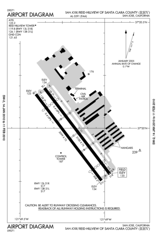
Reid–Hillview Airport of Santa Clara County is in the eastern part of San Jose, in Santa Clara County, California, United States. It is owned by Santa Clara County and is near the Evergreen district of San Jose where aviation pioneer John J. Montgomery experimented with gliders in 1911. Reid–Hillview Airport was also the official general aviation airport for the 2015 Super Bowl in Levi's Stadium.
Avey Field State Airport is a public use airport located on the Canada–US border at Laurier, in Ferry County, Washington, United States. It is privately owned and operated.

Cuyahoga County Airport, also known as Robert D. Shea Field, is a public use airport in northeastern Cuyahoga County, Ohio, United States. Owned and operated by Cuyahoga County since 1946, it also serves Lake County and Geauga County. The airport is located 10 nautical miles east of downtown Cleveland and sits on the border of three cities: Highland Heights, Richmond Heights and Willoughby Hills. It is included in the National Plan of Integrated Airport Systems for 2011–2015, which categorized it as a general aviation reliever airport for Cleveland Hopkins International Airport.
Santa Paula Airport is a privately owned, public use airport located one nautical mile (2 km) southeast of the central business district of Santa Paula, a city in Ventura County, California, United States. It exclusively serves privately operated general aviation aircraft with no scheduled commercial service.

Danbury Municipal Airport is a public use general aviation and commercial airport located three miles (5 km) southwest of the central business district of Danbury, in Fairfield County, Connecticut, United States. The airport opened in 1930. It is currently run by the City of Danbury under the management of Michael Safranek. It is included in the Federal Aviation Administration (FAA) National Plan of Integrated Airport Systems for 2017–2021, in which it is categorized as a regional reliever airport facility.

Renton Municipal Airport is a public use airport located in Renton, a city in King County, Washington, United States. The airport was renamed Clayton Scott Field in 2005 to celebrate the 100th birthday of Clayton Scott. The airport's northern boundary is Lake Washington and the Will Rogers–Wiley Post Memorial Seaplane Base. Renton Airport has a floating dock and a launching ramp for conversion from wheeled landings to water takeoffs and landings.

Door County Cherryland Airport is a county-owned public-use airport in Door County, Wisconsin, United States. It is located two nautical miles (4 km) west of the central business district of Sturgeon Bay, Wisconsin. It is included in the Federal Aviation Administration (FAA) National Plan of Integrated Airport Systems for 2021–2025, in which it is categorized as a local general aviation facility.
Griffith-Merrillville Airport is a public-use airport two miles east of Griffith, in Lake County, Indiana, United States. It is privately owned by Griffith Aviation, Inc.

Mesa Del Rey Airport is a public airport a mile northeast of King City, in Monterey County, California, United States. The National Plan of Integrated Airport Systems for 2011–2015 categorized it as a general aviation facility.
San Martin Airport — formerly Q99 — is a public non-towered airport located one mile (1.6 km) east of San Martin, serving Santa Clara County, California, United States. This general aviation airport covers 179 acres (72 ha) and has one runway. A self-service fueling facility offers 94UL aviation gasoline continuously. Jet-A fuel is available from a full-service truck during FBO operating hours, and major airframe and powerplant service are available. San Martin Aviation is the fixed-base operator (FBO) at South County, serving aviation fuels and aircraft & hangar maintenance.

James Clements Municipal Airport is a city-owned, public-use airport located three nautical miles (6 km) south of the central business district of Bay City, in Bay County, Michigan, United States. It is included in the Federal Aviation Administration (FAA) National Plan of Integrated Airport Systems for 2017–2021, in which it is categorized as a local general aviation facility. It is also a seaplane base with landing areas on the Saginaw River, adjacent to the airport.
Fairfield County Airport is a public use airport in Fairfield County, Ohio, United States. It is located three nautical miles (6 km) northwest of the central business district of Lancaster, the county seat. The airport is owned by the Fairfield County Commissioners.

The Palo Alto Baylands Nature Preserve, known officially as the Baylands Nature Preserve, is the largest tract of undisturbed marshland remaining in the San Francisco Bay. Fifteen miles of multi-use trails provide access to a unique mixture of tidal and fresh water habitats. The preserve encompasses 1,940 acres in both Palo Alto and East Palo Alto, and is owned by the city of Palo Alto, California, United States. It is an important habitat for migratory shorebirds and is considered one of the best birdwatching spots on the West Coast.
Stephen A. Bean Municipal Airport is a town owned, public use airport located two nautical miles (4 km) northwest of the central business district of Rangeley, a town in Franklin County, Maine, United States. It is included in the National Plan of Integrated Airport Systems for 2011–2015, which categorized it as a general aviation facility.