Parkman, Maine

Last updated

Parkman, Maine
Piscataquis County Maine incorporated and unincorporated areas Parkman highlighted.svg
Location in Piscataquis County and the state of Maine.
Coordinates: 45°7′33″N69°26′10″W / 45.12583°N 69.43611°W / 45.12583; -69.43611
Country United States
State Maine
County Piscataquis
IncorporatedJanuary 29, 1822
Area
[1]
  Total46.05 sq mi (119.27 km2)
  Land45.23 sq mi (117.15 km2)
  Water0.82 sq mi (2.12 km2)
Elevation
735 ft (224 m)
Population
 (2020)
  Total747
  Density17/sq mi (6.4/km2)
Time zone UTC-5 (Eastern (EST))
  Summer (DST) UTC-4 (EDT)
ZIP code
04443
Area code 207
FIPS code 23-56765
GNIS feature ID0579055

Parkman is a town in Piscataquis County, Maine, United States. The population was 747 at the 2020 census. [2]

Contents

History

First known as Plantation Number Five, Sixth Range, it was purchased by Samuel Parkman, a Boston Brahmin. [3] In 1822, it was incorporated as a town and named for its proprietor. It was inherited by the proprietor's son, George Parkman, who visited it annually. Much of the town has excellent soil for farming. In 1837, the wheat crop was 6,018 bushels. [4] In 1859, it was noted for making butter and cheese. [5] By 1886, Parkman had several sawmills and a gristmill. [6]

Geography

According to the United States Census Bureau, the town has a total area of 46.05 square miles (119.27 km2), of which 45.23 square miles (117.15 km2) is land and 0.82 square miles (2.12 km2) is water. [1] Parkman is drained by a branch of the Piscataquis River. The principal bodies of water are Bennett and Harlow ponds.

Demographics

Historical population
CensusPop.Note
1820 255
1830 802214.5%
1840 1,20550.2%
1850 1,2433.2%
1860 1,166−6.2%
1870 1,105−5.2%
1880 1,005−9.0%
1890 813−19.1%
1900 718−11.7%
1910 646−10.0%
1920 565−12.5%
1930 538−4.8%
1940 5818.0%
1950 5901.5%
1960 530−10.2%
1970 457−13.8%
1980 62135.9%
1990 79027.2%
2000 8112.7%
2010 8433.9%
2020 747−11.4%
U.S. Decennial Census [7]

2010 census

As of the census [8] of 2010, there were 843 people, 353 households, and 241 families residing in the town. The population density was 18.6 inhabitants per square mile (7.2/km2). There were 538 housing units at an average density of 11.9 per square mile (4.6/km2). The racial makeup of the town was 97.7% White, 0.1% African American, 0.5% Native American, 0.1% Asian, 0.5% from other races, and 1.1% from two or more races. Hispanic or Latino of any race were 2.6% of the population.

There were 353 households, of which 28.0% had children under the age of 18 living with them, 58.1% were married couples living together, 5.9% had a female householder with no husband present, 4.2% had a male householder with no wife present, and 31.7% were non-families. 24.4% of all households were made up of individuals, and 7.9% had someone living alone who was 65 years of age or older. The average household size was 2.39 and the average family size was 2.83.

The median age in the town was 45.2 years. 21.5% of residents were under the age of 18; 6.7% were between the ages of 18 and 24; 21.6% were from 25 to 44; 35.2% were from 45 to 64; and 14.9% were 65 years of age or older. The gender makeup of the town was 52.2% male and 47.8% female.

2000 census

As of the census [9] of 2000, there were 811 people, 311 households, and 222 families residing in the town. The population density was 17.8 people per square mile (6.9/km2). There were 498 housing units at an average density of 10.9 per square mile (4.2/km2). The racial makeup of the town was 98.03% White, 0.86% African American, 0.12% Native American, 0.12% Asian, and 0.86% from two or more races. Hispanic or Latino of any race were 0.49% of the population.

There were 311 households, out of which 35.7% had children under the age of 18 living with them, 61.4% were married couples living together, 6.4% had a female householder with no husband present, and 28.3% were non-families. 21.5% of all households were made up of individuals, and 9.0% had someone living alone who was 65 years of age or older. The average household size was 2.61 and the average family size was 3.03.

In the town, the population was spread out, with 27.6% under the age of 18, 4.9% from 18 to 24, 30.5% from 25 to 44, 25.9% from 45 to 64, and 11.1% who were 65 years of age or older. The median age was 38 years. For every 100 females, there were 109.0 males. For every 100 females age 18 and over, there were 106.7 males.

The median income for a household in the town was $28,355, and the median income for a family was $32,000. Males had a median income of $26,207 versus $20,313 for females. The per capita income for the town was $11,965. About 8.5% of families and 15.4% of the population were below the poverty line, including 11.8% of those under age 18 and 21.8% of those age 65 or over.

Notable people

Related Research Articles

<span class="mw-page-title-main">Piscataquis County, Maine</span> County in Maine, United States

Piscataquis County is a county located in the U.S. state of Maine. As of the 2020 census, its population was 16,800, making it Maine's least-populous county. Its county seat is Dover-Foxcroft. The county was incorporated on March 23, 1838, taken from the western part of Penobscot County and the eastern part of Somerset County. It is named for an Abenaki word meaning "branch of the river" or "at the river branch."

<span class="mw-page-title-main">Strong, Maine</span> Town in Maine, United States

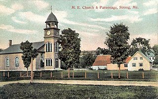
Strong is a town in Franklin County, Maine, United States. The population was 1,122 at the 2020 census. Strong is home to the annual Sandy River Festival.

<span class="mw-page-title-main">Rome, Maine</span> Town in the state of Maine, United States

Rome is a town in Kennebec County, Maine, United States. The population was 1,148 at the 2020 census. It is part of the Belgrade Lakes resort area, and is included in the Augusta, Maine, micropolitan New England City and Town Area.

<span class="mw-page-title-main">Dresden, Maine</span> Town in the state of Maine, United States

Dresden is a town in Lincoln County, Maine, United States, that was incorporated in 1794. The population was 1,725 at the 2020 census.

<span class="mw-page-title-main">Abbot, Maine</span> Town in the state of Maine, United States

Abbot is a town in Piscataquis County, Maine, United States. The population was 650 at the 2020 census. It was named for the treasurer of Bowdoin College, John Abbot.

<span class="mw-page-title-main">Atkinson, Maine</span> Township in Maine, United States

Atkinson is an unincorporated township and former town in Piscataquis County, Maine, United States, and part of the unorganized territory of Southeast Piscataquis, Maine. Its population was 326 at the 2010 census.

<span class="mw-page-title-main">Beaver Cove, Maine</span> Town in the state of Maine, United States

Beaver Cove is a town in Piscataquis County, Maine, United States. The population was 133 at the 2020 census.

<span class="mw-page-title-main">Bowerbank, Maine</span> Town in the state of Maine, United States

Bowerbank is a town in Piscataquis County, Maine, United States. The population was 136 at the 2020 census.

<span class="mw-page-title-main">Brownville, Maine</span> Town in the state of Maine, United States

Brownville is a town in Piscataquis County, Maine, United States. The population was 1,139 at the 2020 census. The town includes the villages of Brownville, Knight's Landing and Brownville Junction, near which passes the 100-Mile Wilderness of the Appalachian Trail.

<span class="mw-page-title-main">Lake View Plantation, Maine</span> Plantation in Maine, United States

Lake View is a plantation in Piscataquis County, Maine, United States. The population was 150 at the 2020 census.

<span class="mw-page-title-main">Medford, Maine</span> Town in the state of Maine, United States

Medford is a town in Piscataquis County, Maine, United States. The population was 230 at the 2020 census.

<span class="mw-page-title-main">Sebec, Maine</span> Town in the state of Maine, United States

Sebec is a town in Piscataquis County, Maine, United States. The population was 665 at the 2020 census.

<span class="mw-page-title-main">Shirley, Maine</span> Town in the state of Maine, United States

Shirley is a town in Piscataquis County, Maine, United States. The town was named after Shirley, Massachusetts. The population was 251 at the 2020 census. It was the birthplace of humorist Bill Nye.

<span class="mw-page-title-main">Wellington, Maine</span> Town in the state of Maine, United States

Wellington is a town in Piscataquis County, Maine, United States. The town was named for Arthur Wellesley, 1st Duke of Wellington. The population was 229 at the 2020 census.

<span class="mw-page-title-main">Bowdoin, Maine</span> Town in the state of Maine, United States

Bowdoin is a town in Sagadahoc County, Maine, United States. Bowdoin is included in the Lewiston-Auburn, Maine metropolitan New England city and town area. The population was 3,136 at the 2020 census. Bowdoin is 31 land miles north of Portland, and 21 land miles south of Augusta.

<span class="mw-page-title-main">Northeast Piscataquis, Maine</span> Unorganized territory in Maine, United States

Northeast Piscataquis is an unincorporated area in Piscataquis County, Maine, United States. The population was 304 at the 2020 census.

<span class="mw-page-title-main">Greenville, Maine</span> Town in the state of Maine, United States

Greenville is a town in Piscataquis County, Maine, United States. The population was 1,437 at the 2020 census. The town is centered on the lower end of Moosehead Lake, the largest body of fresh water in the state. Greenville is the historic gateway to the north country and a center for outdoor recreation in the area. Greenville High School, with 89 students, was ranked as the third best high school in Maine and one of the top 1,000 in the US in 2010.

<span class="mw-page-title-main">Dover-Foxcroft, Maine</span> Town in Maine, United States

Dover-Foxcroft is the largest town in and the seat of Piscataquis County, Maine, United States. The population was 4,422 at the 2020 census. The town is located near the geographic center of the state.

<span class="mw-page-title-main">Guilford, Maine</span> Town in the state of Maine, United States

Guilford is a town in Piscataquis County, Maine, United States. The town is located on the Piscataquis River and was first settled in 1806. The population was 1,267 at the time of the 2020 census.

<span class="mw-page-title-main">Milo, Maine</span> Town in the state of Maine, United States

Milo is a town in Piscataquis County, Maine, United States. The population was 2,251 at the 2020 census. Milo includes the village of Derby. The town sits in the valley of the Piscataquis, Sebec and Pleasant Rivers in the foothills of the Longfellow Mountains and is the gateway to many pristine hunting, fishing, hiking, boating, and other outdoor tourist locations such as Schoodic, Seboeis, and Sebec Lakes, Mount Katahdin and its backcountry in Baxter State Park and the Katahdin Woods and Waters National Monument, Katahdin Iron Works and Gulf Hagas.

References

  1. 1 2 "US Gazetteer files 2010". United States Census Bureau . Retrieved December 16, 2012.
  2. "Census - Geography Profile: Parkman town, Piscataquis County, Maine" . Retrieved January 23, 2022.
  3. "Profile for Parkman, Maine". ePodunk . Retrieved May 7, 2010.
  4. Hayward's New England Gazetteer of 1839
  5. Coolidge, Austin J.; John B. Mansfield (1859). A History and Description of New England. Boston, Massachusetts: A.J. Coolidge. p.  248. coolidge mansfield history description new england 1859.
  6. George J. Varney, History of Parkman, Maine; Boston, 1886
  7. "Census of Population and Housing". Census.gov. Retrieved June 4, 2015.
  8. "U.S. Census website". United States Census Bureau . Retrieved December 16, 2012.
  9. "U.S. Census website". United States Census Bureau . Retrieved January 31, 2008.

45°08′01″N69°25′59″W / 45.13361°N 69.43306°W / 45.13361; -69.43306