Willimantic, Maine

Last updated

Willimantic, Maine
Piscataquis County Maine incorporated and unincorporated areas Willimantic highlighted.svg
Location in Piscataquis County and the state of Maine.
Coordinates: 45°18′11″N69°22′47″W / 45.30306°N 69.37972°W / 45.30306; -69.37972
Country United States
State Maine
County Piscataquis
Area
[1]
  Total47.91 sq mi (124.09 km2)
  Land43.18 sq mi (111.84 km2)
  Water4.73 sq mi (12.25 km2)
Elevation
367 ft (112 m)
Population
 (2020)
  Total134
  Density3/sq mi (1.2/km2)
Time zone UTC-5 (Eastern (EST))
  Summer (DST) UTC-4 (EDT)
Area code 207
FIPS code 23-85710
GNIS feature ID0582815

Willimantic is a town in Piscataquis County, Maine, United States. The population was 134 according to the 2020 census. [2]

Contents

Name

The town was originally named Howard; after the Willimantic Linen Company erected a woodworking factory in 1879 to produce spools for thread, it was renamed in 1881 to Willimantic, after Willimantic, Connecticut. [3] The name Willimantic was first rendered by English colonists as Waramanticut in 1684, [4] [5] and its origin is Algonquian (either Mohegan-Pequot or Narragansett). The meaning is uncertain, with one translation being "land of the swift running water," and another, "place near the evergreen swamp." [6]

Geography

According to the United States Census Bureau, the town has a total area of 47.91 square miles (124.09 km2), of which 43.18 square miles (111.84 km2) is land and 4.73 square miles (12.25 km2) is water. [1]

Demographics

Historical population
CensusPop.Note
1870 267
1890 446
1900 419−6.1%
1910 271−35.3%
1920 196−27.7%
1930 173−11.7%
1940 1888.7%
1950 1890.5%
1960 137−27.5%
1970 126−8.0%
1980 16430.2%
1990 1703.7%
2000 135−20.6%
2010 15011.1%
2020 134−10.7%
U.S. Decennial Census [7]

2010 census

As of the census [8] of 2010, there were 150 people, 69 households, and 43 families living in the town. The population density was 3.5 inhabitants per square mile (1.4/km2). There were 298 housing units at an average density of 6.9 per square mile (2.7/km2). The racial makeup of the town was 98.0% White, 1.3% Native American, and 0.7% from two or more races.

There were 69 households, of which 15.9% had children under the age of 18 living with them, 55.1% were married couples living together, 2.9% had a female householder with no husband present, 4.3% had a male householder with no wife present, and 37.7% were non-families. 29.0% of all households were made up of individuals, and 10.1% had someone living alone who was 65 years of age or older. The average household size was 2.17 and the average family size was 2.72.

The median age in the town was 52 years. 17.3% of residents were under the age of 18; 4.7% were between the ages of 18 and 24; 12.7% were from 25 to 44; 42.7% were from 45 to 64; and 22.7% were 65 years of age or older. The gender makeup of the town was 49.3% male and 50.7% female.

2000 census

As of the census [9] of 2000, there were 135 people, 55 households, and 39 families living in the town. The population density was 3.1 people per square mile (1.2/km2). There were 225 housing units at an average density of 5.2 per square mile (2.0/km2). The racial makeup of the town was 91.11% White, 3.70% Native American, 1.48% from other races, and 3.70% from two or more races. Hispanic or Latino of any race were 1.48% of the population.

There were 55 households, out of which 27.3% had children under the age of 18 living with them, 60.0% were married couples living together, 7.3% had a female householder with no husband present, and 27.3% were non-families. 21.8% of all households were made up of individuals, and 10.9% had someone living alone who was 65 years of age or older. The average household size was 2.45 and the average family size was 2.90.

In the town, the population was spread out, with 25.2% under the age of 18, 3.7% from 18 to 24, 21.5% from 25 to 44, 32.6% from 45 to 64, and 17.0% who were 65 years of age or older. The median age was 45 years. For every 100 females, there were 117.7 males. For every 100 females age 18 and over, there were 110.4 males.

The median income for a household in the town was $26,250, and the median income for a family was $29,375. Males had a median income of $40,000 versus $33,125 for females. The per capita income for the town was $14,206. There were 20.0% of families and 26.6% of the population living below the poverty line, including 39.3% of under eighteens and 57.1% of those over 64.

Related Research Articles

<span class="mw-page-title-main">Piscataquis County, Maine</span> County in Maine, United States

Piscataquis County is a county located in the U.S. state of Maine. As of the 2020 census, its population was 16,800, making it Maine's least-populous county. Its county seat is Dover-Foxcroft. The county was incorporated on March 23, 1838, taken from the western part of Penobscot County and the eastern part of Somerset County. It is named for an Abenaki word meaning "branch of the river" or "at the river branch."

<span class="mw-page-title-main">Abbot, Maine</span> Town in the state of Maine, United States

Abbot is a town in Piscataquis County, Maine, United States. The population was 650 at the 2020 census. It was named for the treasurer of Bowdoin College, John Abbot.

<span class="mw-page-title-main">Atkinson, Maine</span> Township in Maine, United States

Atkinson is an unincorporated township and former town in Piscataquis County, Maine, United States, and part of the unorganized territory of Southeast Piscataquis, Maine. Its population was 326 at the 2010 census.

<span class="mw-page-title-main">Beaver Cove, Maine</span> Town in the state of Maine, United States

Beaver Cove is a town in Piscataquis County, Maine, United States. The population was 133 at the 2020 census.

<span class="mw-page-title-main">Bowerbank, Maine</span> Town in the state of Maine, United States

Bowerbank is a town in Piscataquis County, Maine, United States. The population was 136 at the 2020 census.

<span class="mw-page-title-main">Medford, Maine</span> Town in the state of Maine, United States

Medford is a town in Piscataquis County, Maine, United States. The population was 230 at the 2020 census.

<span class="mw-page-title-main">Parkman, Maine</span> Town in the state of Maine, United States

Parkman is a town in Piscataquis County, Maine, United States. The population was 747 at the 2020 census.

<span class="mw-page-title-main">Sangerville, Maine</span> Town in the state of Maine, United States

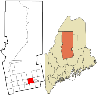
Sangerville is a town in Piscataquis County, Maine, United States. The population was 1,306 at the 2020 census. The town was named after Colonel Calvin Sanger, a landowner.

<span class="mw-page-title-main">Sebec, Maine</span> Town in the state of Maine, United States

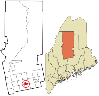
Sebec is a town in Piscataquis County, Maine, United States. The population was 665 at the 2020 census.

<span class="mw-page-title-main">Wellington, Maine</span> Town in the state of Maine, United States

Wellington is a town in Piscataquis County, Maine, United States. The town was named for Arthur Wellesley, 1st Duke of Wellington. The population was 229 at the 2020 census.

Athens is a town in Somerset County, Maine, United States. The population was 952 at the 2020 census.

<span class="mw-page-title-main">Midwest, Wyoming</span> Town in Wyoming, United States

Midwest is a town in Natrona County, Wyoming, United States. It is part of the Casper, Wyoming Metropolitan Statistical Area. The population was 404 at the 2010 census.

<span class="mw-page-title-main">Northeast Piscataquis, Maine</span> Unorganized territory in Maine, United States

Northeast Piscataquis is an unincorporated area in Piscataquis County, Maine, United States. The population was 304 at the 2020 census.

<span class="mw-page-title-main">Northwest Piscataquis, Maine</span> Unorganized territory in Maine, United States

Northwest Piscataquis is an unincorporated area in Piscataquis County, Maine, United States. The population was 134 at the 2020 census.

<span class="mw-page-title-main">Greenville, Maine</span> Town in the state of Maine, United States

Greenville is a town in Piscataquis County, Maine, United States. The population was 1,437 at the 2020 census. The town is centered on the lower end of Moosehead Lake, the largest body of fresh water in the state. Greenville is the historic gateway to the north country and a center for outdoor recreation in the area. Greenville High School, with 89 students, was ranked as the third best high school in Maine and one of the top 1,000 in the US in 2010.

<span class="mw-page-title-main">Dover-Foxcroft (CDP), Maine</span> CDP in Maine, United States

Dover-Foxcroft is a census-designated place (CDP) in the town of Dover-Foxcroft in Piscataquis County, Maine, United States. The population was 2,592 at the 2000 census.

<span class="mw-page-title-main">Greenville (CDP), Maine</span> CDP in Maine, United States

Greenville is a census-designated place (CDP) in the town of Greenville in Piscataquis County, Maine, United States. The population was 1,010 at the 2020 census.

<span class="mw-page-title-main">Guilford (CDP), Maine</span> CDP in Maine, United States

Guilford is a census-designated place (CDP) in the town of Guilford in Piscataquis County, Maine, United States. The population was 945 at the 2000 census.

<span class="mw-page-title-main">Guilford, Maine</span> Town in the state of Maine, United States

Guilford is a town in Piscataquis County, Maine, United States. The town is located on the Piscataquis River and was first settled in 1806. The population was 1,267 at the time of the 2020 census.

<span class="mw-page-title-main">Milo (CDP), Maine</span> CDP in Maine, United States

Milo is a census-designated place (CDP) in the town of Milo in Piscataquis County, Maine, United States. The population was 1,898 at the 2000 census.

References

  1. 1 2 "US Gazetteer files 2010". United States Census Bureau . Retrieved December 16, 2012.
  2. "Census - Geography Profile: Willimantic town, Piscataquis County, Maine" . Retrieved March 13, 2022.
  3. Public Archaeology Survey Team. "History of Willimantic, The Thread City" . Retrieved June 6, 2018.
  4. Trumbull, J. Hammond (1859). The Public Records of the Colony of Connecticut, May, 1678 - June, 1689. Case, Lockwood & Co. p. 202. Retrieved June 5, 2018.
  5. Douglas-Lithgow, Robert Alexander (1909). Dictionary of American-Indian place and proper names in New England: with many interpretations, etc. Salem Press. p.  296 . Retrieved June 5, 2018.
  6. Eves, Jamie H.; Eves, Katherine L. S. "Swift Waters or Cedar Swamp? Native American Placenames in Connecticut and the Meaning of "Willimantic"". Windham Textile and History Museum . Retrieved June 4, 2018.
  7. "Census of Population and Housing". Census.gov. Retrieved June 4, 2015.
  8. "U.S. Census website". United States Census Bureau . Retrieved December 16, 2012.
  9. "U.S. Census website". United States Census Bureau . Retrieved January 31, 2008.

45°18′24″N69°24′30″W / 45.30667°N 69.40833°W / 45.30667; -69.40833