
Los Angeles Union Station is the main train station in Los Angeles, California, and the largest passenger rail terminal in the Western United States. It opened in May 1939 as the Los Angeles Union Passenger Terminal, replacing La Grande Station and Central Station.

Civic Center/Grand Park station is an underground rapid transit station on the B Line and D Line of the Los Angeles Metro Rail system. The station also has street level stops for the J Line of the Los Angeles Metro Busway system. The station is located under Hill Street at its intersection with 1st Street. It is located in the Civic Center neighborhood of Los Angeles, after which the station is named, alongside the nearby Grand Park.

Pershing Square station is an underground rapid transit station on the B Line and D Line of the Los Angeles Metro Rail system. The station also has street-level stops for the J Line of the Los Angeles Metro Busway system. The station is located under Hill Street between 4th and 5th Street. It is located in Downtown Los Angeles with one station entrance across the street from Pershing Square, after which the station is named, and the other is located near the historic Angels Flight funicular which provides access to the high-rise office buildings in the Bunker Hill neighborhood.

7th Street/Metro Center station is an underground light rail and rapid transit station on the A, B, D, and E lines of the Los Angeles Metro Rail system. The station also has street level stops for the J Line of the Los Angeles Metro Busway system. The station is located under 7th Street, after which the station is named, at its intersections with Figueroa, Flower and Hope Streets.

North Hollywood station is a combined rapid transit and bus rapid transit (BRT) station in the Los Angeles Metro Rail and Metro Busway systems. It is the northwestern terminus of the B Line subway and eastern terminus of the G Line BRT route. It is located at the intersection of Lankershim Boulevard and Chandler Boulevard in the NoHo Arts District of the North Hollywood neighborhood in the San Fernando Valley of Los Angeles.

The Harbor Transitway is a 10.3-mile (16.6 km) shared-use express bus corridor and high occupancy toll (HOT) lanes running in the median of Interstate 110 between Downtown Los Angeles and the Harbor Gateway Transit Center in Gardena, California. Buses also make intermediate stops at 37th Street/USC, Slauson, Manchester, Harbor Freeway, and Rosecrans stations. The facility opened for two-person carpools on June 26, 1996, for buses on August 1, 1996 and was converted to HOT lanes as part of the Metro ExpressLanes project on November 10, 2012.

The El Monte Busway is a 12-mile (19 km) shared-use express bus corridor (busway) and high occupancy toll (HOT) lanes running along Interstate 10 between Union Station in Downtown Los Angeles and Interstate 605 or El Monte Station in El Monte, California. Buses also make intermediate stops at Cal State LA station and LA County+USC Medical Center station. The busway opened in January 1973 to buses only, three-person carpools were allowed to enter in 1976, and the facility was converted to HOT lanes as part of the Metro ExpressLanes project on February 22, 2013.

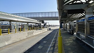
37th Street/USC station is a busway station located in Los Angeles, California. It is situated between the LATTC/Ortho Institute and Slauson stations on the J Line, a bus rapid transit route which runs between El Monte, Downtown Los Angeles and San Pedro as part of the Metro Busway system. The station consists of two side platforms in the center of Interstate 110 above 37th Street, adjacent to the University of Southern California campus. The station serves the University Park, Exposition Park and Historic South Central neighborhoods of Los Angeles.
Slauson station is a busway station located in Los Angeles, California. It is situated between the 37th Street/USC and Manchester stations on the J Line, a bus rapid transit route which runs between El Monte, Downtown Los Angeles and San Pedro as part of the Metro Busway system. The station consists of two side platforms in the center of Interstate 110 above Slauson Avenue. The station serves the Vermont-Slauson, South Park and Florence neighborhoods of Los Angeles.

Manchester station is a busway station located in Los Angeles, California. It is situated between the Slauson and Harbor Freeway stations on the J Line, a bus rapid transit route which runs between El Monte, Downtown Los Angeles and San Pedro as part of the Los Angeles Metro Busway system. The station consists of two side platforms in the center of Interstate 110 above Manchester Avenue. The station serves the Vermont Knolls, Vermont Vista, Florence, and Broadway-Manchester neighborhoods of Los Angeles.

Rosecrans station is a busway station located in Los Angeles, California. It is situated between the Harbor Freeway station and the Harbor Gateway Transit Center on the J Line, a bus rapid transit route which runs between El Monte, Downtown Los Angeles and San Pedro as part of the Metro Busway system. The station consists of two side platforms in the center of Interstate 110 under Rosecrans Avenue. The station serves the Harbor Gateway neighborhoods of Los Angeles.

Los Angeles County+USC Medical Center station is a busway station located in the Boyle Heights neighborhood of Los Angeles, California. It is situated between Union Station and Cal State LA station on the El Monte Busway. The station is served by two bus rapid transit routes: the J Line, operated by Metro and the Silver Streak, operated by Foothill Transit. It is also used by several Metro Express and Foothill Transit bus services, most of which only run during weekday peak periods. The station consists of an island platforms in the center of the El Monte Busway, near its then namesake, the Los Angeles County+USC Medical Center. The station was completed on November 4, 1974, and is accessed by a bridge from Pomeroy Avenue between Kingston Avenue and Brittania Street. Metro intends to change the name to "LA General Medical Center" to reflect the hospital's new name.

Cal State LA station is a commuter train and bus station located on the El Monte Busway. The station is located between Interstate 10 and its namesake, the campus of California State University, Los Angeles. It is located in the El Sereno neighborhood of the City of Los Angeles and Eastside region, in southern California. The busway portion of the station opened on February 18, 1975 and the Metrolink platform was added on October 26, 1994.

El Monte Station is a large regional bus station in the city of El Monte, California, United States, adjacent to Interstate 10, serving the Metro J Line, Foothill Transit, Greyhound Lines, and El Monte Transit. It is the Metro J Line's eastern terminus.

Silver Streak is a bus rapid transit route between Montclair and Los Angeles operated by Foothill Transit. Between the Montclair TransCenter and the El Monte Bus Station, buses travel on the San Bernardino Freeway. Between El Monte and Downtown Los Angeles, buses use the El Monte Busway. The service was introduced in 2007 in response to overcrowding on Foothill Transit route 480. It runs 24 hours a day, with hourly service in the late evening.

The J Line is a 38-mile (61.2 km) bus rapid transit line that runs between El Monte, Downtown Los Angeles and the Harbor Gateway, with some trips continuing to San Pedro. It is one of the two lines in the Metro Busway system operated by the Los Angeles County Metropolitan Transportation Authority (Metro).

Metro Busway is a system of bus rapid transit (BRT) routes that operate primarily along exclusive or semi-exclusive roadways known locally as a busway or transitway. There are currently two lines serving 29 stations in the system, the G Line in the San Fernando Valley, and the J Line between El Monte, Downtown Los Angeles and Gardena, with some trips continuing to San Pedro. The Los Angeles County Metropolitan Transportation Authority (Metro) operates the system.
The Metro ExpressLanes project is a transport project in Los Angeles County, California that debuted in 2012 to "improve traffic flow and provide enhanced travel options on I-10 and I-110 in Los Angeles County". It includes a range of infrastructure developments on the Harbor Transitway and the El Monte Busway. The existing high-occupancy lanes on these transitways were converted to high-occupancy toll lanes. Associated works included a major upgrade to the El Monte bus station, expansion of Metrolink's Pomona–North station, the creation of a new transit station at Union Station, and increased park and ride capacity and bike lockers at many transit stations. In addition, new vanpool vehicles and buses will be purchased. The project was delivered by the Los Angeles County Metropolitan Transportation Authority, the California Department of Transportation, and others. The budget was $290 million and construction, which began in 2011, was completed in February 2013. Some transit improvements for the Metro Silver Line are still being worked on.

Grand Avenue Arts/Bunker Hill station is an underground light rail station on the A and E lines of the Los Angeles Metro Rail system. The station also has street level stops for the J Line of the Los Angeles Metro Busway system. The station is located under the intersection of 2nd Place and Hope Street, near the Grand Avenue Arts district and in the Bunker Hill neighborhood of Downtown Los Angeles, after which the station is named. In planning documents, the station was originally referred to as 2nd Place/Hope.


