Interstate 4 (I-4) is an Interstate Highway located entirely within the US state of Florida, maintained by the Florida Department of Transportation (FDOT). Spanning 132.30 miles (212.92 km) along a generally southwest–northeast axis, I-4 is entirely concurrent with State Road 400 (SR 400). In the west, I-4 begins at an interchange with I-275 in Tampa. I-4 intersects with several major expressways as it traverses Central Florida, including US Highway 41 (US 41) in Tampa; US 301 near Riverview; I-75 near Brandon; US 98 in Lakeland; US 27 in unincorporated Davenport; US 192 in Celebration; Florida's Turnpike in Orlando; and US 17 and US 92 in multiple junctions. In the east, I-4 ends at an interchange with I-95 in Daytona Beach, while SR 400 continues for roughly another four miles (6.4 km) and ends at an intersection with US 1 on the city line of Daytona Beach and South Daytona.

U.S. Route 90 or U.S. Highway 90 (US 90) is an east–west major United States highway in the Southern United States. Despite the "0" in its route number, US 90 never was a full coast-to-coast route. It generally travels near Interstate 10 (I-10) and passes through the southern states of Texas, Louisiana, Mississippi, Alabama, and Florida. US 90 also includes part of the DeSoto Trail between Tallahassee and Lake City, Florida.

The Sunshine Skyway Bridge, sometimes referred to as the Bob Graham Sunshine Skyway Bridge, the Sunshine Skyway, or simply "the Skyway", is a pair of long beam bridges with a central tall cable-stayed bridge that spans Lower Tampa Bay to connect Pinellas County to Manatee County. The current Sunshine Skyway opened in 1987 and is the second bridge of that name on the site. It was designed by the Figg & Muller Engineering Group and built by the American Bridge Company. The bridge is considered the flagship bridge of Florida and serves as a gateway to Tampa Bay. The four-lane bridge carries Interstate 275 and U.S. Route 19, passing through Pinellas County, Hillsborough County and Manatee County. It is a toll bridge, with a toll assessed on two-axle vehicles traveling in either direction at a rate of $1.75 cash or $1.16 with the state's SunPass system.

Pensacola Beach is an unincorporated community located on Santa Rosa Island, a barrier island, in Escambia County, Florida, United States. It is situated south of Pensacola in the Gulf of Mexico. As of the 2000 census, the community had a total population of 2,738. It has been described as "famous" for its ultra-white sand beaches.

The Shands Bridge is a two-lane automobile bridge carrying SR 16 over the St. Johns River south of Jacksonville, Florida.

The Sanibel Causeway is a causeway in Southwest Florida that spans San Carlos Bay, connecting Sanibel Island with the Florida mainland in Punta Rassa. The causeway consists of three separate two-lane bridge spans, and two-man-made causeway islands between them. The entire causeway facility is owned by Lee County and operated by the Lee County Department of Transportation. The entire causeway is 3 miles (5 km) long from end to end, and currently has a $6 toll in effect for island-bound vehicles only. The bridges are not individually named, and are simply referred to as bridges A, B, and C. The islands are also named A and B. Both series begin from the mainland side.

The W. Howard Frankland Bridge is the central fixed-link bridge spanning Old Tampa Bay from St. Petersburg, Florida to Tampa, Florida. It is one of three bridges connecting Hillsborough County and Pinellas County; the others being Gandy Bridge and Courtney Campbell Causeway. The bridge carries Interstate 275 and is by far the most traveled of the bay's bridges.

The Lee Roy Selmon Expressway is a 14.168-mile (22.801 km) controlled-access toll road in Hillsborough County, Florida. It connects the South Tampa neighborhood near MacDill Air Force Base with Downtown Tampa and the bedroom community of Brandon. The expressway was built in stages, opening between 1976 and 1987. An approximately 1.9-mile extension to the thoroughfare's western terminus opened to traffic on Monday, April 19, 2021.

Gandy Bridge is the southernmost bridge spanning Old Tampa Bay from St. Petersburg, Florida to Tampa, Florida. The original 1924 span was dismantled in 1975. The second bridge, constructed in 1956 was used for vehicular traffic until 1997, when it was converted to recreational use by non-motorized traffic. It became known as the Friendship Trail Bridge and was demolished in 2016, after closing in 2008 due to hazardous conditions and several failed efforts to preserve the span. The third (1975) and fourth (1997) spans of the Gandy Bridge are currently being used for vehicle traffic.

State Road 404 (SR 404), the Pineda Causeway, is an east–west divided highway currently running from Interstate 95 (I-95) to SR A1A at Patrick Space Force Base, Florida, US. It was opened as a toll road in 1971 and classified as a state road two years later. The tolls were removed in 1990. It was named after Pineda, a former village east of Suntree on U.S. Route 1 (US 1). With interchanges at US 1 (SR 5), South Tropical Trail, and South Patrick Drive (SR 513), the Pineda Causeway is the primary access for Patrick Space Force Base and the southern end of Merritt Island. From US 1 to the eastern terminus, it is part of the Indian River Lagoon Scenic Highway system.

State Road 30 is the mostly hidden Florida Department of Transportation designation for most of US 98 from the Florida-Alabama state line to east of Perry, Florida.
The Great River Bridge is an asymmetrical, single tower cable-stayed bridge over the Mississippi River. It carries U.S. Route 34 from Burlington, Iowa to the town of Gulf Port, Illinois.

Interstate 10 (I-10) runs for 362 miles (583 km) in Florida as the easternmost section of an east–west Interstate Highway in the southern United States. It is also the eastern end of one of three coast-to-coast Interstates, along with I-80 and I-90. The highway runs east from the Alabama border, traveling through the Panhandle of Florida, serving the major cities of Pensacola, Tallahassee, Lake City, ending at Jacksonville, and carries the hidden Florida Department of Transportation (FDOT) designation of State Road 8 (SR 8).

The Escambia Bay Bridge is a six-lane freeway bridge that carries Interstate 10 (I-10) across Escambia Bay near Pensacola, Florida.
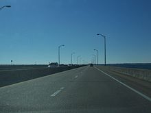
The Garcon Point Bridge is a 2-lane toll bridge in Santa Rosa County, in the Florida panhandle. The bridge generally runs north - south and connects U.S. Route 98 east of Gulf Breeze, Florida to Interstate 10 and U.S. Route 90 west of Milton, Florida. The road and bridge uses the TOLL 281 shield on signage from US 98 to I-10. North of I-10 the road is signed solely as State Road 281. Exit signs on I-10 display both the State Road 281 and TOLL 281 shields. The bridge crosses East Bay, a large section of Pensacola Bay and serves as an evacuation route during hurricanes.
The I-4/Selmon Expressway Connector is a controlled-access toll road between I-4, the Lee Roy Selmon Expressway (SR 618), and the Port of Tampa east of Ybor City in the city of Tampa, Florida. It primarily comprises four parallel one-way roadways west of 31st Street, continuously elevated over local streets, railroads, and vacant land, with a SunPass/toll-by-plate electronic toll gantry spanning the structure near the southern end. All movements were opened to traffic on January 6, 2014, and the direct connections to the Port of Tampa are signed as Truck Routes.

U.S. Route 98 is a major east-west thoroughfare through the U.S. state of Florida. Spanning 670.959 miles (1,079.804 km), it connects Pensacola and the Alabama/Florida state line to the west with Palm Beach and the Atlantic coast in the east. It is the longest US road in Florida, as well as the longest US road in any state east of the Mississippi River.
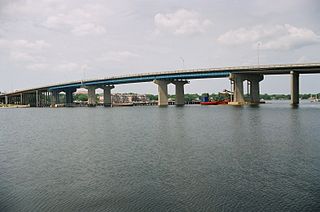
The Brooks Bridge is a four-lane steel and concrete structure that carries highway U.S. Route 98 (US 98) over Santa Rosa Sound just west of the Choctawhatchee Bay between downtown Fort Walton Beach, Florida and the 3-mile-long (4.8 km) section of Okaloosa Island controlled by the city of Fort Walton Beach. It is named for John Thomas Brooks, who, in 1868, purchased 111 acres of what is now downtown Fort Walton Beach. The area on the north side of the sound where the bridge connects was known as Brooks Landing. It has a charted clearance of 50 feet (15 m) above the water.

The San Mateo–Hayward Bridge is a bridge crossing the American state of California's San Francisco Bay, linking the San Francisco Peninsula with the East Bay. The bridge's western end is in Foster City, a suburb on the eastern edge of San Mateo. The eastern end of the bridge is in Hayward. It is the longest fixed-link bridge in California and the 25th longest in the world by length. The bridge is owned by the state of California, and is maintained by California Department of Transportation (Caltrans), the state highway agency. Further oversight is provided by the Bay Area Toll Authority (BATA).

Hurricane Sally was a destructive and slow-moving Atlantic hurricane that was the first hurricane to make landfall in the U.S. state of Alabama since Ivan in 2004, coincidentally on the same date in the same place. The eighteenth named storm and seventh hurricane of the extremely active 2020 Atlantic hurricane season, Sally developed from an area of disturbed weather which was first monitored over the Bahamas on September 10. The system grew a broad area of low-pressure on September 11, and was designated as a tropical depression late that day. Early the next day, the depression made landfall at Key Biscayne and subsequently strengthened into Tropical Storm Sally that afternoon. Moderate northwesterly shear prevented significant intensification for the first two days, but convection continued to grow towards the center and Sally slowly intensified. On September 14, a center reformation into the center of the convection occurred, and data from a hurricane hunter reconnaissance aircraft showed that Sally had rapidly intensified into a strong Category 1 hurricane. However, an increase in wind shear and upwelling of colder waters halted the intensification and Sally weakened slightly on September 15 before turning slowly northeastward. Despite this increase in wind shear, it unexpectedly re-intensified, reaching Category 2 status early on September 16 before making landfall at peak intensity at 09:45 UTC on September 16, near Gulf Shores, Alabama, with maximum sustained winds of 110 mph (180 km/h) and a minimum central pressure of 965 millibars (28.5 inHg). The storm rapidly weakened after landfall before transitioning into an extratropical low at 12:00 UTC the next day. Sally's remnants lasted for another day as they moved off the coast of the Southeastern United States before being absorbed into another extratropical storm on September 18.