
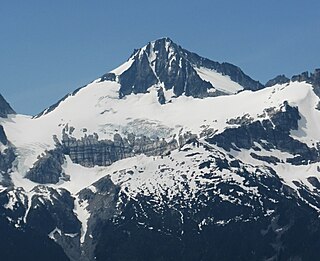
Klawatti Peak is located in North Cascades National Park in the U.S. state of Washington. Klawatti Peak is a nunatak, a peak surrounded by glaciers. These are Klawatti Glacier to the east, McAllister Glacier to the northwest and Inspiration Glacier to the south.
Primus Peak is located in North Cascades National Park in the U.S. state of Washington. Primus Peak is flanked by North Klawatti Glacier to the south and Borealis Glacier to the northeast. Tricouni Peak is situated immediately east of Primus Peak.

Kimtah Peak, elevation 8,600+ feet, is in North Cascades National Park in the U.S. state of Washington. Kimtah Peak is a summit along a ridge known as Ragged Ridge. Kimtah Glacier is on the northwest slopes of the peak, while Katsuk Glacier is to the northeast.

Tower Mountain is a prominent non-volcanic mountain located on the boundary line of Okanogan and Skagit counties in Washington state. It is part of the Okanogan Range which is a sub-range of the North Cascades Range. Tower Mountain situated on land administered by the Okanogan–Wenatchee National Forest.

Cutthroat Peak is an 8,050-foot-elevation (2,450-meter) granitic mountain located on the boundary of Chelan County and Skagit County, in Washington state. The mountain is part of the Okanagan Range which is a subset of the Cascade Range, and is situated within the Okanogan-Wenatchee National Forest. Cutthroat Peak is about two miles west of Washington Pass and one mile east of Rainy Pass. It's a prominent landmark along the North Cascades Highway with an accessible climbing route. There is also a Cutthroat Lake, Cutthroat Creek, and Cutthroat Pass on its north and east aspects. This geographical feature's name was officially adopted in 1988 by the United States Board on Geographic Names. Molar Tooth is a granite pillar half a mile north on the ridge extending to Cutthroat Pass.

Fisher Peak is an 8,040-foot-elevation mountain summit located in the North Cascades of Washington state. It is situated on the borders of the Stephen Mather Wilderness and North Cascades National Park, midway between Black Peak and Easy Pass, and adjacent to Repulse Peak. Precipitation runoff from Fisher Peak drains into tributaries of the Skagit River.

Paul Bunyans Stump is a 7,480+ ft mountain summit in the North Cascades Range of Washington, United States. It is located within North Cascades National Park. It rises steeply from Diablo Lake, one of the reservoirs on the Skagit River. It is part of a group of peaks that form the northern end of a chain running south through climbing destinations such as Colonial Peak and Snowfield Peak. The nearest peak to Paul Bunyans Stump is Pinnacle Peak, 0.37 mi (0.60 km) to the north, and the nearest higher peak is Neve Peak, 0.9 mi (1.4 km) to the southeast. Like many North Cascade peaks, Paul Bunyans Stump is more notable for its large, steep rise above local terrain than for its absolute elevation. Precipitation runoff from the mountain drains into Diablo Lake and Skagit River.
Beebe Mountain is a 7,416-foot (2,260-metre) mountain summit located in the Cascade Range in the U.S. state of Washington. It is situated on the border of North Cascades National Park. Its nearest higher neighbor is Elija Ridge, 1.86 miles (2.99 km) to the southwest, and McKay Ridge is set 4 miles (6.4 km) to the northeast on the opposite side of the North Cascades Highway. The mountain's name honors Frank Beebe who worked for the Forest Service and maintained a cabin near the base of the mountain in the 1920s. Precipitation runoff on the mountain drains into Ross Lake via Granite Creek and Panther Creek.

Trapper Mountain is a 7,530-foot (2,300-metre) summit located in Chelan County of Washington state. It is part of the North Cascades Range. Trapper Mountain is situated southeast of Cascade Pass on the shared border of North Cascades National Park and Glacier Peak Wilderness. The nearest higher peak is Hurry-up Peak, 0.92 miles (1.48 km) to the west. Surface runoff from the mountain drains into Trapper Lake and tributaries of the Stehekin River.

The Triplets is a 7,240+ ft summit located in Skagit County of Washington state. This breccia triple pinnacle is part of the North Cascades Range. The Triplets is situated above Cascade Pass on the shared border of North Cascades National Park and Glacier Peak Wilderness. The nearest higher neighbor is Cascade Peak, 0.35 miles (0.56 km) to the west-northwest. Surface runoff from the mountain drains into the Cascade River.

Repulse Peak is a 7,923-foot (2,415-metre) mountain summit in the North Cascades in the U.S. state of Washington. It is located on the border of the Stephen Mather Wilderness and North Cascades National Park. It's situated midway between Black Peak and Fisher Peak, and can be seen from the North Cascades Highway. Precipitation runoff from Repulse Peak drains into tributaries of the Skagit River and Stehekin River.

McKay Ridge is a 7,000+ ft ridge located in Whatcom County in Washington state. It is part of the Okanogan Range which is a sub-range of the North Cascades. It's situated north of the North Cascades Highway on land administered by the Okanogan–Wenatchee National Forest. The nearest higher peak is Majestic Mountain, 1.6 miles (2.6 km) to the northeast. Precipitation runoff from the ridge drains into Ross Lake via tributaries of the Skagit River.

Jumbo Mountain, is a 5840+ ft summit near the western edge of the North Cascades, in Snohomish County of Washington state. It is located four miles south of Darrington, Washington, along the Mountain Loop Highway. It is situated in the Boulder River Wilderness on land administered by the Mount Baker-Snoqualmie National Forest. The mountain was named by miners for its resemblance to an elephant. The nearest higher peak is Buckeye Peak, 3.34 miles (5.38 km) to the west. Precipitation runoff from Jumbo Mountain drains into tributaries of the Stillaguamish River and Sauk River.

The Roost is a 6,705 ft summit in the Picket Range which is a sub-range of the North Cascades Range of Washington state, United States. It is located within North Cascades National Park and Stephen Mather Wilderness, and is situated one mile north of Mount Ross. Like many North Cascades peaks, The Roost is more notable for its large, steep rise above local terrain than for its absolute elevation. The Roost was first climbed on July 12, 1966 by John and Taffy Roper. The nearest higher neighbor is Glee Peak, 1.76 miles (2.83 km) to the north. Precipitation runoff from the mountain drains into the Skagit River.

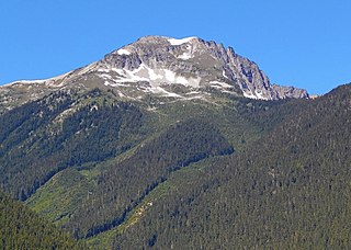
Red Mountain is a 7,662 feet (2,335 m) summit in the North Cascades Range of Washington, United States. It is located in Skagit County and within North Cascades National Park and the Stephen Mather Wilderness. It is situated on a smooth ridge of brick-red color at the western culmination of Ragged Ridge.

Hurry-up Peak is a 7,821-foot-elevation summit located on the shared boundary of Skagit County and Chelan County in Washington state. It is positioned on the crest of the North Cascades Range, and is set at the northern end of the Ptarmigan Traverse. Hurry-up Peak is situated southeast of Cascade Pass on the shared border of North Cascades National Park and Glacier Peak Wilderness. The nearest higher peak is Spider Mountain, 1.49 miles (2.40 km) to the south, with Magic Mountain 0.83 miles (1.34 km) to the north, and Trapper Mountain 0.7 miles (1.1 km) to the east. The S Glacier rests on the eastern flank of the peak and meltwater from it drains into Trapper Lake. Precipitation runoff on the east side the mountain drains into tributaries of the Stehekin River, while precipitation drains into the Cascade River from the west side. Ess Mountain and S Mountain are variant names for Hurry-up Peak. This geographical feature's name was officially adopted in 1969 by the U.S. Board on Geographic Names.
Hagan Mountain is a multi-peak mountain located in Whatcom County, Washington state, within North Cascades National Park. It has an elevation of 7,080-foot (2,160-metre). The mountain is situated approximately 12 mi (19 km) north of Marblemount.

Pinnacle Peak is a 7,360+ ft mountain summit in the North Cascades Range of Washington, United States. It is located within North Cascades National Park, between Pyramid Peak and Paul Bunyans Stump, which is the nearest higher peak. It rises steeply from Diablo Lake, one of the reservoirs on the Skagit River. It is part of a group of peaks that form the northern end of a chain running south through climbing destinations such as Colonial Peak and Snowfield Peak. Like many North Cascade peaks, Pinnacle Peak is more notable for its large, steep rise above local terrain than for its absolute elevation. Precipitation runoff from the mountain drains into Diablo Lake and Skagit River. The approach is via the Pyramid Lake Trail, starting near Diablo Dam on the North Cascades Highway. From the lake, there is route-finding up Pyramid Arm to Colonial Glacier.

Genesis Peak is a 7,244 ft (2,210 m) mountain summit located in the North Cascades, in Whatcom County of Washington, United States. It is situated within North Cascades National Park and Stephen Mather Wilderness. The nearest higher neighbor is Mount Prophet, 2.22 miles (3.57 km) to the northwest. Like many North Cascade peaks, Genesis Peak is more notable for its large, steep rise above local terrain than for its absolute elevation. Topographic relief is significant since the southern aspect of the mountain rises 5,400 feet above the Big Beaver Valley in approximately 2 mi (3.2 km), and the eastern aspect of the mountain rises 5,600 feet above Ross Lake in approximately 3 mi (4.8 km). Precipitation runoff from the mountain drains into Ross Lake via Skymo, No Name, and Big Beaver Creeks. The first ascent of this peak was made September 13, 1975, by Norman Burke, Cliff Lawson, Ed Lebert, and Dan Sjolseth.

Gabriel Peak is a prominent 7,920-foot (2,410 m)-elevation mountain summit located in North Cascades National Park, in Skagit County of Washington state. It is part of the North Cascades which is a subset of the Cascade Range. The nearest higher neighbor is Cosho Peak, 2.7 miles (4.3 km) to the south, Beebe Mountain is set 2.5 miles (4.0 km) to the north, and Red Mountain is 3 miles (4.8 km) to the southwest. Precipitation runoff from this feature drains to Ross Lake via Gabriel and Panther Creeks. Like many North Cascade peaks, Gabriel Peak is more notable for its large, steep rise above local terrain than for its absolute elevation. Topographic relief is significant as it rises 4,700 feet (1,400 m) above the Panther Creek valley in approximately one mile. This geographical feature is named after the archangel Gabriel, which is a reference to Tommy Rowland who settled in the Skagit River area in 1895 and later pronounced himself the "Prophet Elisha." Mount Prophet, Genesis Peak, and nearby Elija Ridge were also named in association with Rowland.


