Pinzberg

Last updated
Pinzberg
Pinzberg-alte Schmiede.JPG
Center of the village
DEU Pinzberg COA.svg
Location of Pinzberg within Forchheim district
Pinzberg in FO.svg
Germany adm location map.svg
Red pog.svg
Pinzberg
Bavaria location map.svg
Red pog.svg
Pinzberg
Coordinates: 49°42′N11°6′E / 49.700°N 11.100°E / 49.700; 11.100 Coordinates: 49°42′N11°6′E / 49.700°N 11.100°E / 49.700; 11.100
Country Germany
State Bavaria
Admin. region Oberfranken
District Forchheim
Municipal assoc. Gosberg
Government
   Mayor (202026) Elisabeth Simmerlein [1]
Area
  Total13.33 km2 (5.15 sq mi)
Elevation
336 m (1,102 ft)
Population
 (2020-12-31) [2]
  Total1,973
  Density150/km2 (380/sq mi)
Time zone UTC+01:00 (CET)
  Summer (DST) UTC+02:00 (CEST)
Postal codes
91361
Dialling codes 09191
Vehicle registration FO
Website https://www.pinzberg.de/

Pinzberg is a municipality in the district of Forchheim in Bavaria in Germany.

Contents

Pinzberg lies in the region Upper Franconia west.

The following districts exist: Dobenreuth, Gosberg, Pinzberg, Elsenberg.

History

Pinzberg belonged to the Prince-Bishopric of Bamberg. Since the realm deputation main conclusion of 1803, Pinzberg belongs to Bavaria. In the course of the administrative reforms in Bavaria, today's municipality developed with the municipality edict of 1818.

Population

Population in the municipality in 1970 was 1,608, in 1987 was 1,696, and in the year 2000, 1,864 inhabitants were counted.

Politics

Since 1996, there is a youth local council in Pinzberg. This was brought into being by the mayor at that time, Reinhardt Glauber. The current youth mayor (in German "Jugendbuergermeister") is Fabian Fridl.

The local council of Pinzberg has 13 members including the mayor.

Coat of arms

The coat of arms reads: In gold an in-curved red point, therein a silver gate tower also on both sides following silver right parallelepiped wall; beseitet in front of a black three-blade clover sheet, in the back of a black grain flower bloom. Pinzberg consists of the villages Dobenreuth, Elsenberg, Gosberg and Pinzberg. All places are to be represented in the coat of arms. The tower is the landmark of Pinzberg and refers to the church tower, that at the same time serves as a gate tower of the cemetery attachment from the second half of 15th Century. The in-curved red point is the symbol of the Holy Trinity and stands for Gosberg and its branch church, which the Holy Trinity is dedicated. The clover sheet stands for Dobenreuth and symbolizes the rare Patrozinium of the holy family. Since the Middle Ages both the terrestrial and the Holy Trinity are often represented by nature forms such as clover sheets. The agriculture of Elsenberg is represented by the cornflower sheet on the coat of arms. The colors gold and black from the Pinzberg coat of arms remind of the long-lasting relationship with the diocese Bamberg. In the year 1062 Heinrich IV gave parts of today's territory of Pinzberg the diocese.

The emblem is used since 1988 on the legal base of a Resolution of the local council and the agreement of the government of Upper Franconia.

Related Research Articles

Eibelstadt Town in Bavaria, Germany

Eibelstadt is a town in the district of Würzburg, in Bavaria, Germany.

Schlüsselfeld Town in Bavaria, Germany

Schlüsselfeld is a town on the southwestern edge of the Upper Franconian district of Bamberg

Stadtprozelten Town in Bavaria, Germany

Stadtprozelten is a town and municipality in the Miltenberg district in the Regierungsbezirk of Lower Franconia (Unterfranken) in Bavaria, Germany and the seat of the Verwaltungsgemeinschaft of Stadtprozelten.

Zeil am Main Town in Bavaria, Germany

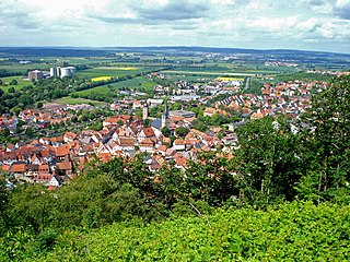
Zeil am Main is a town in the Haßberge district in Lower Franconia, an area in the federal state of Bavaria, Germany. It is situated on the right bank of the Main, 7 km east of Haßfurt, 24 km northwest of Bamberg, and 25 km east of Schweinfurt. Zeil is a historic Franconian town known for its old churches, romantic houses, medieval walls and towers, the hill church of "Zeiler Käpelle", and the castle ruins of the Schmachtenburg.

Wallerstein, Bavaria Municipality in Bavaria, Germany

Wallerstein is a municipality and former principality in the district of Donau-Ries in Bavaria in Germany.

Etzelwang Municipality in Bavaria, Germany

Etzelwang is a municipality in the district of Amberg-Sulzbach in Bavaria in Germany.

Wittelshofen Municipality in Bavaria, Germany

Wittelshofen is a municipality in the district of Ansbach in Bavaria in Germany.

Kleinkahl Municipality in Bavaria, Germany

Kleinkahl is a community in the Aschaffenburg district in the Regierungsbezirk of Lower Franconia (Unterfranken) in Bavaria, Germany, and a member of the Verwaltungsgemeinschaft of Schöllkrippen. Kleinkahl has around 1,800 inhabitants.

Altendorf, Upper Franconia Municipality in Bavaria, Germany

Altendorf is a community in the Upper Franconian district of Bamberg, Bavaria, Germany.

Burgwindheim Municipality in Bavaria, Germany

Burgwindheim is a municipality with market rights in the west of the Upper Franconian district of Bamberg and a member of the administrative community (Verwaltungsgemeinschaft) of Ebrach.

Gerach Municipality in Bavaria, Germany

Gerach is a community in the Upper Franconian district of Bamberg and a member of the administrative community (Verwaltungsgemeinschaft) of Baunach. It lies in the Naturpark Haßberge roughly 20 km north of Bamberg and roughly 10 km south of Ebern.

Gundelsheim, Bavaria Municipality in Bavaria, Germany

Gundelsheim is a community in the Upper Franconian district of Bamberg.

Lauter, Bavaria Municipality in Bavaria, Germany

Lauter is a community in the Upper Franconian district of Bamberg and a member of the administrative community (Verwaltungsgemeinschaft) of Baunach.

Rattelsdorf Municipality in Bavaria, Germany

Rattelsdorf is a municipality with market rights in the Upper Franconian district of Bamberg.

Gößweinstein Municipality in Bavaria, Germany

Gößweinstein is a municipality in the district of Forchheim in Bavaria in Germany. It lies within the region known as Franconian Switzerland.

Kleinsendelbach Municipality in Bavaria, Germany

Kleinsendelbach is a municipality in the district of Forchheim in Bavaria in Germany. It is located about 17 Kilometers south of the town of Forchheim and 15 Kilometers to the east of the city of Erlangen, and is part of the administration community Dormitz.

Aidhausen Municipality in Bavaria, Germany

Aidhausen is a municipality in the district of Haßberge in Bavaria in Germany, it is a member of the Verwaltungsgemeinschaft Hofheim in Unterfranken.

Gattendorf Municipality in Bavaria, Germany

Gattendorf is a municipality in Upper Franconia in the district of Hof in Bavaria in Germany.

Trogen, Bavaria Municipality in Bavaria, Germany

Trogen is a municipality in Upper Franconia in the district of Hof in Bavaria in Germany.

Röllbach Municipality in Bavaria, Germany

Röllbach is a municipality in the Miltenberg district in the Regierungsbezirk of Lower Franconia (Unterfranken) in Bavaria, Germany and a member of the Verwaltungsgemeinschaft of Mönchberg.

References

  1. Liste der ersten Bürgermeister/Oberbürgermeister in kreisangehörigen Gemeinden, Bayerisches Landesamt für Statistik, 15 July 2021.
  2. "Tabellenblatt "Daten 2", Statistischer Bericht A1200C 202041 Einwohnerzahlen der Gemeinden, Kreise und Regierungsbezirke". Bayerisches Landesamt für Statistik (in German). June 2021.