Pittsfield, New York

Last updated

Pittsfield, New York
Otsego County outline map Pittsfield red.png
Otsego County map with the Town of Pittsfield in Red
Coordinates: 42°38′N75°16′W / 42.633°N 75.267°W / 42.633; -75.267
Country United States
State New York
County Otsego
Area
[1]
  Total38.09 sq mi (98.66 km2)
  Land37.98 sq mi (98.36 km2)
  Water0.12 sq mi (0.30 km2)
Elevation
1,752 ft (534 m)
Population
 (2010)
  Total1,366
  Estimate 
(2016) [2]
1,300
  Density34.23/sq mi (13.22/km2)
Time zone UTC-5 (Eastern (EST))
  Summer (DST) UTC-4 (EDT)
FIPS code 36-58343
GNIS feature ID0979371

Pittsfield is a town in Otsego County, New York, United States. The population was 1,366 at the 2010 census.

Contents

The Town of Pittsfield is on the western border of the county, northwest of the City of Oneonta.

History

The town was first settled circa 1793.

The Town of Pittsfield was formed from part of the Town of Burlington in 1797. The territory of Pittsfield was reduced two times, in 1806 to form Town of New Lisbon, and in 1859 to form part of the Town of Morris. It was named by the Noble family from Pittsfield, Massachusetts, for their old home, who settled in the Pittsfield Centre vicinity.

The hamlet of Pittsfield, or "Pittsfield Centre", had an unmanned whistle stop station and siding on the Ontario & Western RR branch to Edmeston from New Berlin, later purchased by the Unadilla Valley RR. During World War I Richard Freeman and Charles Walton shipped lumber by the carload from here, milled over in Ketchum.

Ketchum takes its name from the Rev. Orvib Ketchum who founded a congregational church on the headwaters of Aldrich Creek in the east part of town, the church was later sold by the Wyoming Conference to the Americana Village near Hamilton, NY. A schoolhouse, store, several steam sawmills and cemetery also existed here. The Ball family operated several "rope walks" nearby, where hemp was wound into twine and then rope.

County Route 13 between Morris and New Berlin is referred to as "the turnpike" by locals, originally constructed in 1832, it was the last section to operate a tollgate due to being the most expensive to build.

Ebenezer Chapel, near the southwest border, was coincidentally named after a nearby resident, and was a small settlement originally known as "Hayti" at one time. In 1956, a nearby house made statewide news when a moonshine still was busted up.

The Beardslee Farm was listed on the National Register of Historic Places in 2000. [3]

Geography

According to the United States Census Bureau, the town has a total area of 37.8 square miles (98 km2), of which 37.7 square miles (98 km2) is land and 0.1 square miles (0.26 km2) (0.13%) is water.

The western town line, defined by the Unadilla River, is the border of Chenango County. Wharton Creek flows into the Unadilla River at the western town line. Aldrich Creek drains the east end of town southwards into the Butternut at Elm Grove in Morris.

New York State Route 80 passes through the northwestern part of the town.

Demographics

Historical population
CensusPop.Note
1820 839
1830 1,00519.8%
1840 1,39538.8%
1850 1,59114.1%
1860 1,480−7.0%
1870 1,469−0.7%
1880 1,450−1.3%
1890 1,218−16.0%
1900 1,101−9.6%
1910 917−16.7%
1920 813−11.3%
1930 727−10.6%
1940 7969.5%
1950 8506.8%
1960 8803.5%
1970 96810.0%
1980 1,06710.2%
1990 1,1164.6%
2000 1,29516.0%
2010 1,3665.5%
2016 (est.)1,300 [2] −4.8%
U.S. Decennial Census [4]

As of the census [5] of 2000, there were 1,295 people, 474 households, and 359 families residing in the town. The population density was 34.3 inhabitants per square mile (13.2/km2). There were 605 housing units at an average density of 16.0 per square mile (6.2/km2). The racial makeup of the town was 98.84% White, 0.23% African American, 0.15% Native American, 0.23% Asian, 0.08% from other races, and 0.46% from two or more races. Hispanic or Latino of any race were 0.69% of the population.

There were 474 households, out of which 36.5% had children under the age of 18 living with them, 63.3% were married couples living together, 7.2% had a female householder with no husband present, and 24.1% were non-families. 19.2% of all households were made up of individuals, and 9.1% had someone living alone who was 65 years of age or older. The average household size was 2.73 and the average family size was 3.03.

In the town, the population was spread out, with 27.3% under the age of 18, 5.9% from 18 to 24, 28.3% from 25 to 44, 26.8% from 45 to 64, and 11.7% who were 65 years of age or older. The median age was 38 years. For every 100 females, there were 104.6 males. For every 100 females age 18 and over, there were 104.6 males.

The median income for a household in the town was $30,078, and the median income for a family was $36,328. Males had a median income of $27,446 versus $21,912 for females. The per capita income for the town was $15,347. About 13.5% of families and 17.0% of the population were below the poverty line, including 20.9% of those under age 18 and 12.3% of those age 65 or over.

Communities and locations in Pittsfield

Related Research Articles

<span class="mw-page-title-main">Guilford, New York</span> Town in New York, United States

Guilford is a town in Chenango County, New York, United States. The town is on the eastern border of the county. The population was 2,922 at the 2010 census.

<span class="mw-page-title-main">Black Brook, New York</span> Town in New York, United States

Black Brook is a town in Clinton County, New York, United States. The population was 1,497 at the 2010 census. It is named after a stream that flows through the town.

<span class="mw-page-title-main">Columbia, New York</span> Town in New York, United States

Columbia is a town in Herkimer County, New York, United States. As of the 2020 census, the town population was 1,569. The town is at the southern border of the county and is southeast of Utica.

<span class="mw-page-title-main">Winfield (town), New York</span> Town in New York, United States

Winfield is a town in Herkimer County, New York, United States. The population was 2,086 at the 2010 census. The town is named after General Winfield Scott and is in the southwestern corner of the county, south of Utica.

<span class="mw-page-title-main">Sangerfield, New York</span> Town in New York, United States

Sangerfield is a town in Oneida County, New York, United States. The population was 2,561 at the 2010 census. The town is named after Jedediah Sanger, an early settler.

<span class="mw-page-title-main">Vienna, New York</span> Town in New York, United States

Vienna is a town in Oneida County, New York, United States. The population was 5,440 at the 2010 census. The town is named after the capital of Austria.

<span class="mw-page-title-main">Spafford, New York</span> Town in New York, United States

Spafford is a town in Onondaga County, New York, United States. As of the 2020 Census, the population was 1,588. The town was named after Horatio Gates Spafford, a writer and founder of the local library. Spafford is in the southwestern corner of Onondaga County and is southwest of Syracuse.

<span class="mw-page-title-main">Hastings, New York</span> Town in New York, United States

Hastings is a town in Oswego County, New York, United States. Its population was 9,450 at the 2010 census. It is named after Hastings Curtiss, a prominent citizen and member of the State Assembly in 1824.

<span class="mw-page-title-main">Palermo, New York</span> Town in New York, United States

Palermo is a town in Oswego County in the U.S. state of New York. The population was 3,664 at the 2010 census. The town is named after Palermo in Sicily.

<span class="mw-page-title-main">Butternuts, New York</span> Town in New York, United States

Butternuts is a town located in Otsego County, New York, United States. As of the 2010 census, the town had a population of 1,786. The Town of Butternuts is located in the southwestern part of the county, and is west of Oneonta.

<span class="mw-page-title-main">Edmeston, New York</span> Town in New York, United States

Edmeston is a town located in Otsego County, New York, United States. As of the 2010 census, the town had a total population of 1,826.

<span class="mw-page-title-main">Plainfield, New York</span> Town in New York, United States

Plainfield is a town in Otsego County, New York, United States. The population was 915 at the 2010 census.

<span class="mw-page-title-main">Fowler, New York</span> Town in New York, United States

Fowler is a town in St. Lawrence County, New York, United States. The population was 2,202 at the 2010 census.

<span class="mw-page-title-main">New Berlin, New York</span> Town in New York, United States

New Berlin is a town in Chenango County, central New York, United States. The population was 2,682 at the 2010 census. The town contains the village of New Berlin. The town is at the eastern border of the county and is northeast of Norwich.

<span class="mw-page-title-main">Norwich (town), New York</span> Town in New York, United States

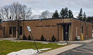
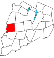
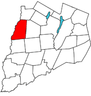
Norwich is a town in Chenango County, New York, United States. The population was 3,998 at the 2010 census.

<span class="mw-page-title-main">Milford, New York</span> Town in New York, United States

Milford is a town in Otsego County, New York, United States. The population was 3,044 at the 2010 census. Within town is the village of Milford. The town is northeast of the City of Oneonta.

<span class="mw-page-title-main">Morris, New York</span> Town in New York, United States

Morris is a town located in Otsego County, New York, United States. As of the 2010 census, the town had a population of 1,878. The town is named after General Jacob Morris.

<span class="mw-page-title-main">Unadilla, New York</span> Town in New York, United States

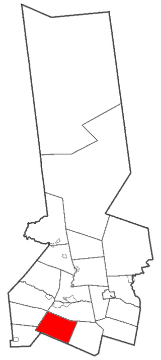
Unadilla is a town in Otsego County, New York, United States. As of the 2010 census, the town had a population of 4,392. The name is derived from an Iroquois word for "meeting place". Unadilla is located in the southwestern corner of the county, southwest of Oneonta. The village of Unadilla is located in the southern part of the town. The mayor of Unadilla is Jason Cotten.

<span class="mw-page-title-main">Stillwater, New York</span> Town in New York, United States

Stillwater is a town in Saratoga County, New York, United States, with a population of 8,287 at the 2010 census. The town contains a village called Stillwater. The town is at the eastern border of the county, southeast of Saratoga Springs and borders both Rensselaer and Washington counties. Saratoga National Historical Park is located within the town's limits. There is a hamlet in Minerva, Essex County, New York, with the same name which has nothing to do with this town.

<span class="mw-page-title-main">Owego, New York</span> Town in Tioga County, New York, US

Owego is a town in Tioga County, New York, United States. The population was 18,728 at the 2020 census. The name is derived from the Iroquois word Ahwaga, meaning "where the valley widens".

References

  1. "2016 U.S. Gazetteer Files". United States Census Bureau. Retrieved July 5, 2017.
  2. 1 2 "Population and Housing Unit Estimates" . Retrieved June 9, 2017.
  3. "National Register Information System". National Register of Historic Places . National Park Service. March 13, 2009.
  4. "Census of Population and Housing". Census.gov. Retrieved June 4, 2015.
  5. "U.S. Census website". United States Census Bureau . Retrieved January 31, 2008.

42°38′N75°16′W / 42.633°N 75.267°W / 42.633; -75.267