Port of Gaza

Last updated
Port of Gaza
GazaPort.JPG
Gaza port, 2015
Port of Gaza
Click on the map for a fullscreen view
Location
Country State of Palestine
Location Gaza Governorate, Gaza Strip
Coordinates 31°31′33″N34°25′50″E / 31.52583°N 34.43056°E / 31.52583; 34.43056
Grid position096/104 PAL
UN/LOCODE PSGZA [1]
Details
Operated by Palestinian National Authority
Land area48,000 m2 (520,000 sq ft)
No. of piers 970 and 330 m (3,180 and 1,080 ft)

The Port of Gaza is a small port near the Rimal district of Gaza City, Palestine. [2] It is the home port of Palestinian fishing-boats and the base of the Palestinian Naval Police, a branch of the Palestinian National Security Forces. Under the Oslo II Accord, the activities of the Palestinian Naval Police are restricted to 6 nautical miles from the coast. [3] Since 2007, the Port of Gaza has been under an Israeli-imposed naval blockade as part of a blockade of the Gaza Strip, and activities at the port have been restricted to small-scale fishing.

Contents

History

Gaza Strip

The Gaza Strip has been put under a strict blockade, by land, air, and sea. [4] Having total surface area of 362 square kilometers, [5] the transportation system in the strip is in poor condition with only 76 kilometres (47 mi) of main roads, 122 kilometres (76 mi) of regional roads, and 99 kilometres (62 mi) of local roads. [4] Formerly the Gaza strip had a small airport located at Rafah, but the airport was destroyed in 2001 by Israel. [4] The port was built by the Palestinian National Authority (PNA). [4]

Maiuma

In earlier times, the port of Maiuma, or el Mineh (Arabic for "the harbour"), was located in the area. [6] In the late Ottoman era, Pierre Jacotin named the place Majumas on his map from 1799. [7]

In 1883, the PEF's Survey of Western Palestine (SWP) noted that el Mineh was probably the ancient Maiuma. [8]

In 2011, eight Roman columns believed to be the remains of a church were swept ashore during a storm. [9] In 2013, the Palestinian Naval Police found ancient artifacts that included poles and baked clay. [10]

Since 1994

In 2002, Israeli forces attacked the Palestinian Naval Police facilities in the port, [11] after Naval Police commanders were implicated in the Karine A affair, an attempt to secretly bring in 50 tons of weapons by boat into Gaza.

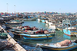
In 2007, following Hamas' takeover of Gaza, Israel imposed a blockade of the Gaza Strip, including a naval blockade. [12] Several attempts to break the Israeli blockade have been made. [13] Israel has prevented most ships from docking at the Port of Gaza, but did allow two boats, carrying activists and some supplies, to reach the port in 2008. [14] As at 2010, the port was restricted to smaller Palestinian fishing boats. [15]

In 2010, the port was deepened by Hamas in preparation for the arrival of a blockade-breaking flotilla of larger international ships. [15]

Gaza Seaport plans

Fishermen at the port in 2019 Fishermen in Gaza.jpg
Fishermen at the port in 2019

Since the 1993 Oslo I Accord, there have been plans to build a much larger seaport in Gaza. Due to the continuing Israeli–Palestinian conflict, these plans have not materialized as of 2024.

In 2005, Israel approved Palestinian plans to rebuild and complete the construction of a port a few miles south of Gaza City, which had begun before the outbreak of the Second Intifada in September 2000. The building was destroyed by Israeli forces together with Gaza's existing airport near Rafah following the outbreak of the Second Intifada. [16]

2023-2024 war

In 2024, the United States Army and Navy began constructing a floating pier at the Port of Gaza to bring in food to the people of the Gaza Strip. [17] The pier was actually built in next door Israel and moved to Gaza. The United States and other countries have also built an offshore platform a kilometre away from this pier. The aid is moved from the platform to this pier. [18] [19] On the 20th of May, the pier was damaged due to rains and wind. [20]

Related Research Articles

<span class="mw-page-title-main">Gaza Strip</span> Self-governing Palestinian territory next to Egypt and Israel

The Gaza Strip, or simply Gaza, is a polity and the smaller of the two Palestinian territories. On the eastern coast of the Mediterranean Sea, Gaza is bordered by Egypt on the southwest and Israel on the east and north.

<span class="mw-page-title-main">Al-Tall, Acre</span> Village in Acre, Mandatory Palestine

Al-Tall, was a Palestinian village 14 km northeast of Acre in the British Mandate District of Acre. Depopulated as a result of military assault and capture during the 1947-1948 Civil War in Mandatory Palestine as part of Operation Operation Ben-Ami by the Carmeli Brigade of the Israel Defense Forces.

<span class="mw-page-title-main">Nimrin</span> Place in Tiberias, Mandatory Palestine

Nimrin was a Palestinian Arab town of 320 that was captured and depopulated by Israel during the 1948 Arab-Israeli War.

Beit Hanoun or Beit Hanun is a Palestinian city on the northeast edge of the Gaza Strip. According to the Palestinian Central Bureau of Statistics, the town had a population of 52,237 in 2017. From mid-2007 until late 2023, it was administered by the Hamas administration. Beit Hanoun has been entirely depopulated, and virtually all its structures have either been destroyed or rendered unusable due to extreme damage following the Israel-Hamas war. The remains of Beit Hanoun are located by the Nahal-Hanun stream, 6 kilometers (3.7 mi) away from the Israeli town of Sderot.

<span class="mw-page-title-main">Transport in the State of Palestine</span>

This article describes transport in the State of Palestine, which consists of two non-contiguous territories, the West Bank and the Gaza Strip, different parts of which are administered by Palestinian National Authority, Hamas Administration in Gaza and Israel.

<span class="mw-page-title-main">Al-Jiyya</span> Village in Gaza, Mandatory Palestine

al-Jiyya was a Palestinian village that was depopulated during the 1948 Arab-Israeli War. It was located 19 kilometers northeast of Gaza City and had a population of 1,230, according to a 1945 survey. The village was occupied by Israel's Giv'ati Brigade on the 4th November 1948 during Operation Yoav.

<span class="mw-page-title-main">Miska, Tulkarm</span> Village in Tulkarm, Mandatory Palestine

Miska was a Palestinian village, located fifteen kilometers southwest of Tulkarm, depopulated in 1948.

Ein Mahil is an Arab local council in the Northern District of Israel, located about five kilometers north-east of Nazareth. It was declared a local council in 1964. In 2022 it had a population of 13,931, the majority of which are Muslims.

<span class="mw-page-title-main">Rumana, Israel</span> Place in Northern, Israel

Rumana is an Arab village in northern Israel. Located near Nazareth, it falls under the jurisdiction of al-Batuf Regional Council. In 2022 its population was 1,276.

<span class="mw-page-title-main">Blockade of the Gaza Strip</span> 2005–present land, sea and air blockade by Israel and Egypt

A blockade has been imposed on the movement of goods and people in and out of the Gaza Strip since Hamas's takeover in 2007, led by Israel and supported by Egypt. The blockade's current stated aim is to prevent the smuggling of weapons into Gaza; previously stated motivations have included exerting economic pressure on Hamas. Human rights groups have called the blockade illegal and a form of collective punishment, as it restricts the flow of essential goods, contributes to economic hardship, and limits Gazans' freedom of movement. The blockade and its effects have led to the territory being called an "open-air prison".

<span class="mw-page-title-main">Rafidiya</span> Place in Nablus, State of Palestine

Rafidiya is a neighborhood in the western part of the Palestinian city of Nablus. It was a separate village until it was merged into the municipality in 1966. In 1961, Rafidiya had 923 inhabitants, rising to 1,200 in 1983.

<span class="mw-page-title-main">Dayr Sunayd</span> Place in Gaza, Mandatory Palestine

Dayr Sunayd was a Palestinian Arab village in the Gaza Subdistrict, located 12 kilometers (7.5 mi) northeast of Gaza. Situated at an elevation of 50 meters (160 ft) along the southern coastal plain of Palestine, Deir Sunayd had a total land area of 6,081 dunams. Prior to its depopulation during the 1948 Arab–Israeli War, it had 730 inhabitants in 1945.

<span class="mw-page-title-main">Al-Batani al-Sharqi</span> Place in Gaza, Mandatory Palestine

Al-Batani al-Sharqi was a Palestinian Arab village in the Gaza Subdistrict, located 36.5 kilometers (22.7 mi) northeast of Gaza situated in the flat terrain on the southern coastal plain of Palestine. It had a population of 650 in 1945. Al-Batani al-Sharqi was depopulated during the 1948 Arab-Israeli War.

<span class="mw-page-title-main">Al-Batani al-Gharbi</span> Place in Gaza, Mandatory Palestine

Al-Batani al-Gharbi was a Palestinian village in the Gaza Subdistrict. It was depopulated during the 1947–48 Civil War in Mandatory Palestine on May 13, 1948, by the Giv'ati Brigade under Operation Barak. It was located 36 km (22 mi) northeast of Gaza.

<span class="mw-page-title-main">Ni'ilya</span> Place in Gaza, Mandatory Palestine

Ni'ilya was a Palestinian village in the Gaza Subdistrict. It was depopulated during the 1948 Arab–Israeli War on November 4, 1948, under Operation Yo'av. It was located 19 km northeast of Gaza in the city territory of modern Ashkelon. The village was defended by the Egyptian Army.

<span class="mw-page-title-main">Khirbat al-Sawamir</span> Place in Haifa, Mandatory Palestine

Khirbat al-Sawamir was a Palestinian Arab village in the Haifa Subdistrict. It was depopulated during the 1948 Arab-Israeli War on May 22, 1948. It was located 22 kilometres south of Haifa.

<span class="mw-page-title-main">Al-Manshiyya, Tiberias</span> Village in Tiberias, Mandatory Palestine

Al-Manshiyya was a Palestinian Arab village in the Tiberias Subdistrict, located 11 kilometres south of Tiberias. It was probably depopulated at the same time as neighbouring Al-'Ubaydiyya, in the 1947–1948 Civil War in Mandatory Palestine. Manshiyya was located 1 km south-west of Umm Junieh or Khirbat Umm Juni.

<span class="mw-page-title-main">Al-Jalama, Tulkarm</span> Village in Tulkarm, Mandatory Palestine

Al-Jalama or Khirbat al-Jalama was a Palestinian Arab village 8.5 kilometres (5.3 mi) north of Tulkarm. Situated close to the eastern banks of a valley of the same name, it was inhabited during the Crusader and Mamluk periods, and again in Ottoman period by villagers from nearby Attil.

<span class="mw-page-title-main">Egypt–Palestine relations</span> Bilateral relations

Egypt–Palestine relations are the bilateral relations between the Arab Republic of Egypt and the State of Palestine. Egyptian President Gamal Abdel Nasser was a strong supporter of the Palestinian cause and he favored self-determination for the Palestinians. Although the Egyptian government has maintained a good relationship with Israel since the Camp David Accords, most Egyptians strongly resent Israel, and disapprove of the close relationship between the Israeli and Egyptian governments.

The following outline is provided as an overview of and topical guide to the Wikipedia articles available about the Israel–Hamas war. It is an evolving list.

References

  1. "UNLOCODE (PS) - PALESTINE, STATE OF". service.unece.org. Retrieved 25 April 2020.
  2. Doughty and El Aydi, 1995, p. 13
  3. Karsh, Efraim (2013). Israel: the First Hundred Years: Volume II: From War to Peace?. p. 216.
  4. 1 2 3 4 Sarraj, Yahya R. (2018-11-14). "Hourly and Daily Traffic Expansion Factors on Selected Roads in Gaza, Palestine". The Open Civil Engineering Journal. 12 (1): 355–367. doi: 10.2174/1874149501812010355 . ISSN   1874-1495.
  5. Zavadjil, Milan (1997-02-28). Recent Economic Developments, Prospects, and Progress in Institution Building in the West Bank and Gaza Strip. INTERNATIONAL MONETARY FUND. doi:10.5089/9781557756381.071. ISBN   978-1-55775-638-1.
  6. Palmer, 1881, p. 361
  7. Karmon, 1960, p. 173
  8. Conder and Kitchener, 1883, SWP III, p. 236
  9. Gaza's archaeological treasures at risk from war and neglect 7 January 2013, BBC
  10. Gaza naval police excavate archaeological site off the Gaza coast, February 17, 2014, Memo
  11. Israeli navy attacks Gaza port, 12 January 2002, BBC
  12. Israeli navy blocks Gaza aid ship, 1 December 2008, The Guardian
  13. U.S. leftists confirm plans to sail to Gaza to break siege 29 July 2008 U.S. Haaretz
  14. Navy lets another boat into Gaza port, by Yaakov Katz and Herb Keinon 9 December 2008, The Jerusalem Post
  15. 1 2 Gaza port readies for flotilla, May 27, 2010, Jerusalem Post
  16. Palestinians to rebuild Gaza sea port in latest peace move, Anton La Guardia, 17 February 2005, The Daily Telegraph
  17. Kim, Victoria; Boxerman, Aaron (9 March 2024). "As U.S. Rushes to Build Gaza Port, Major Challenges Loom". The New York Times .
  18. Borger, Julian (2024-05-17). "Supplies arrive in Gaza via new pier but land routes essential, says US aid chief". The Guardian. ISSN   0261-3077 . Retrieved 2024-06-04.
  19. Tondo, Lorenzo; Burke, Jason; Tantesh, Malak A.; Borger, Julian (2024-05-16). "US completes installation of floating pier to deliver aid to Gaza". The Guardian. ISSN   0261-3077 . Retrieved 2024-06-04.
  20. Youssef, Nancy A. "Pentagon Shuts Down Floating Pier for Gaza Aid After Storm Damage". WSJ. Retrieved 2024-06-04.

Bibliography

31°31′30.77″N34°25′51.84″E / 31.5252139°N 34.4310667°E / 31.5252139; 34.4310667