Rimal حي الرمال | |
|---|---|
Neighborhood | |
| Remal | |
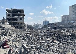 Israeli airstrike destruction in Rimal, October 9, 2023 | |
 Interactive map of Rimal | |
 Rimal Location in Gaza Strip | |
| Coordinates: 31°31′12″N34°26′35″E / 31.52°N 34.4431°E | |
| Grid position | 097/103 PAL |
| Country | |
| Governorate | Gaza Governorate |
| City | Gaza |
| Government | |
| • Control | |
| Time zone | UTC+2 (EET) |
| • Summer (DST) | +3 |
Rimal or Remal (Arabic : حي الرمال, lit. 'sands') is a neighborhood in Gaza City located three kilometers (two miles) from the city center. Situated along the coastline, it was considered the most prosperous neighborhood of Gaza. [1] The main street that runs through Gaza, Omar Mukhtar Street, runs northwest–southeast in the district and the main coastal road, Ahmad Orabi/Rasheed Street, northeast-southwest. [2] Rimal is divided into the city districts of southern Rimal and northern Rimal. [3] The neighborhood is the site of multiple government ministries and has been severely damaged during the ongoing Gaza war. [4]

