
Mission San Carlos Borromeo del Río Carmelo, or Misión de San Carlos Borromeo de Carmelo, first built in 1797, is one of the most authentically restored Catholic mission churches in California. Located at the mouth of Carmel Valley, California, it is on the National Register of Historic Places and is a National Historic Landmark.

Mission Santa Barbara is a Spanish mission in Santa Barbara, California, United States. Often referred to as the 'Queen of the Missions', it was founded by Padre Fermín Lasuén for the Franciscan order on December 4, 1786, the feast day of Saint Barbara, as the tenth mission of what would later become 21 missions in Alta California.
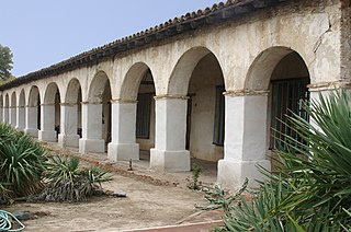
Mission San Miguel Arcángel is a Spanish mission in San Miguel, California. It was established on July 25, 1797 by the Franciscan order, on a site chosen specifically due to the large number of Salinan Indians that inhabited the area, whom the Spanish priests wanted to evangelize.

Hudspeth County is a county located in the U.S. state of Texas. As of the 2020 census, the population was 3,202. Its county seat is Sierra Blanca, and the largest community is Fort Hancock. The county is named for Claude Benton Hudspeth, a state senator and United States Representative from El Paso. It is northeast of the Mexico–U.S. border.

San Elizario is a city in El Paso County, Texas, United States. Its population was 13,603 at the 2010 census. It is part of the El Paso metropolitan statistical area. It lies on the Rio Grande, which forms the border between the United States and Mexico. The city of Socorro adjoins it on the west and the town of Clint lies to the north.

The Spanish Missions in Texas comprise a series of religious outposts established by Spanish Catholic Dominicans, Jesuits, and Franciscans to spread the Catholic doctrine among area Native Americans, but with the added benefit of giving Spain a toehold in the frontier land. The missions introduced European livestock, fruits, vegetables, and industry into the Texas area. In addition to the presidio and pueblo (town), the misión was one of the three major agencies employed by the Spanish crown to extend its borders and consolidate its colonial territories. In all, twenty-six missions were maintained for different lengths of time within the future boundaries of the state of Texas.
Ysleta is a community in El Paso, Texas, United States. Ysleta was settled between October 9 and October 12, 1680, when Spanish conquistadors, Franciscan clerics and Tigua Indians took refuge along the southern bank of the Rio Grande. These people were fleeing the Pueblo Revolt in New Mexico. Ysleta is the oldest European settlement in the area that is the present-day U.S. state of Texas.

El Presidio Real de Santa Bárbara, also known as the Royal Presidio of Santa Barbara, is a former military installation in Santa Barbara, California, United States. The presidio was built by Spain in 1782, with the mission of defending the Second Military District in California. In modern times, the Presidio serves as a significant tourist attraction, museum and an active archaeological site as part of El Presidio de Santa Barbara State Historic Park.

El Presidio Real de San Diego is a historic fort in San Diego, California. It was established on May 14, 1769, by Gaspar de Portolá, leader of the first European land exploration of Alta California—at that time an unexplored northwestern frontier area of New Spain. The presidio was the first permanent European settlement on the Pacific Coast of the present-day United States. As the first of the presidios and Spanish missions in California, it was the base of operations for the Spanish colonization of California. The associated Mission San Diego de Alcalá later moved a few miles away.

The Cathedral of San Carlos Borromeo, also known as the Royal Presidio Chapel, is a Roman Catholic cathedral located in Monterey, California, United States. The cathedral is the oldest continuously operating parish and the oldest stone building in California. It was built in 1791-94 making it the oldest serving cathedral in the United States, along with St. Louis Cathedral in New Orleans, Louisiana. It is the only existing presidio chapel in California and the only existing building in the original Monterey Presidio.

The Camino Real de Tierra Adentro, also known as the Silver Route, was a Spanish 2,560-kilometre-long (1,590 mi) road between Mexico City and San Juan Pueblo, New Mexico, that was used from 1598 to 1882. It was the northernmost of the four major "royal roads" that linked Mexico City to its major tributaries during and after the Spanish colonial era.

The Sánchez Adobe Park, home to the Sánchez Adobe, is located in Pacifica, California, at 1000 Linda Mar Boulevard, on the north bank of San Pedro Creek, approximately 0.91 miles (1,470 m) from the Pacific Ocean in Linda Mar Valley. The 5.46-acre (2.21 ha) county park, established in 1947 contains the Sanchez Adobe Historical site, designated a National Register Historical District in 1976 and is California registered landmark 391.
The San Elizario Salt War, also known as the Salinero Revolt or the El Paso Salt War, was an extended and complex range war of the mid-19th century that revolved around the ownership and control of immense salt lakes at the base of the Guadalupe Mountains in West Texas. What began in 1866 as a political and legal struggle among Anglo Texan politicians and capitalists gave rise in 1877 to an armed struggle by ethnic Mexican and Tejano inhabitants living on both sides of the Rio Grande near El Paso against a leading politician, who was supported by the Texas Rangers. The struggle reached its climax with the siege and surrender of 20 Texas Rangers to a popular army of perhaps 500 men in the town of San Elizario, Texas. The arrival of the African-American 9th Cavalry and a sheriff's posse of New Mexico mercenaries caused hundreds of Tejanos to flee to Mexico, some in permanent exile. The right of individuals to own the salt lakes, which had previously been held as a community asset, was established by force of arms.
The Forts of Texas include a number of historical and operational military installations. For over 200 years, various groups fought over access to or control over the region that is now Texas. Possession of the region was claimed and disputed by the European powers of Spain and France, and the continental countries of Mexico, the United States, the Republic of Texas, and the Confederate States of America. Ownership of specific lands was claimed and disputed by different ethnic groups, including numerous Native American tribes, Mexican residents, Anglo- and African-American settlers, and European immigrants. Access to and control of resources were claimed and disputed by various economic groups, including indigenous hunter/gatherers, farmers, herders, ranchers, colonists, settlers, buffalo hunters, traders, bandits, smugglers, pirates, and revolutionaries. Over the centuries, claims and disputes were enforced by Native American warriors, Spanish conquistadors, French cavaliers, Texas Rangers, local militias, and uniformed regular army regiments of Spain, Mexico, Texas, the United States, and the Confederacy.

The Spanish Governor's Palace is a historic adobe from the Spanish Texas period located in Downtown San Antonio.

The Santa Fe Plaza is a National Historic Landmark in downtown Santa Fe, New Mexico in the style of traditional Spanish-American colonial cities. The plaza, or city square is a gathering place for locals and also a tourist attraction. It is home to annual events including Fiestas de Santa Fe, the Spanish Market, the Santa Fe Bandstand, and the Santa Fe Indian Market.

The original Franciscan mission, Nuestra Señora de la Concepción del Socorro, was founded in 1682 by the Franciscan order, to serve displaced Spanish families, American Indians from New Mexico, who fled the central New Mexico region during the Pueblo Revolt. The present Socorro Mission was constructed around 1839 to replace an earlier 18th-century mission destroyed in 1829 by flooding of the Rio Grande. The mission, constructed of adobe surfaced with stucco, is particularly notable for its interior. The finely painted and decorated beams, or vigas, are from the 18th-century mission and were reused when the present church was constructed. The massing, details and use of decorative elements of the Socorro Mission show strong relationships to the building traditions of 17th-century Spanish New Mexico.

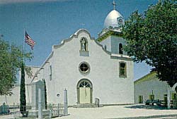
The Ysleta Mission, located in the Ysleta del Sur Pueblo within the municipality of El Paso, Texas, is recognized as the oldest continuously operated parish in the State of Texas. The Ysleta community is also recognized as the oldest in Texas and claims to have the oldest continuously cultivated plot of land in the United States.
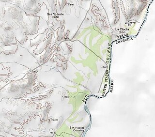
San Vicente was a village located in Brewster County, Texas, within the protruding big bend of the Rio Grande. The village was geographically 1.5 miles (2.4 km) north of the San Vicente Crossing in present-day Big Bend National Park. The uninhabited site provides a panoramic view of the Chisos Mountains and the Sierra San Vicente migrating into Northern Mexico.


