Princess Elizabeth Alps

Last updated
Princess Elizabeth Alps
Prinsesse Elisabeth Alper

1024 Nordpolausflug- Nordostgronland-05052012183.jpg

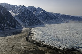
View of the Elephant foot Glacier at Romer Lake with the Princess Elizabeth Alps in the background
Highest point
Elevation 1,466.4 m (4,811 ft)
Dimensions
Length 50 km (31 mi)NNE/SSW
Width 27 km (17 mi)ESE/WSW
Geography
Greenland edcp relief location map.jpg
Red triangle with thick white border.svg
Location
Country Greenland
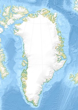
Range coordinates 80°48′N18°48′W / 80.800°N 18.800°W / 80.800; -18.800 Coordinates: 80°48′N18°48′W / 80.800°N 18.800°W / 80.800; -18.800
Geology
Age of rock Caledonian orogeny [1]
Type of rock Fold belt gneiss

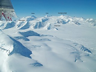
The Princess Elizabeth Alps (Danish : Prinsesse Elisabeth Alper) is a mountain range in King Frederick VIII Land, northeastern Greenland. Administratively this range is part of the Northeast Greenland National Park zone.

Danish language North Germanic language spoken in Denmark

Danish is a North Germanic language spoken by around six million people, principally in Denmark and in the region of Southern Schleswig in northern Germany, where it has minority language status. Also, minor Danish-speaking communities are found in Norway, Sweden, Spain, the United States, Canada, Brazil, and Argentina. Due to immigration and language shift in urban areas, around 15–20% of the population of Greenland speak Danish as their first language.

Mountain range A geographic area containing several geologically related mountains

A mountain range or hill range is a series of mountains or hills ranged in a line and connected by high ground. A mountain system or mountain belt is a group of mountain ranges with similarity in form, structure, and alignment that have arisen from the same cause, usually an orogeny. Mountain ranges are formed by a variety of geological processes, but most of the significant ones on Earth are the result of plate tectonics. Mountain ranges are also found on many planetary mass objects in the Solar System and are likely a feature of most terrestrial planets.

King Frederick VIII Land Region in Greenland

King Frederick VIII Land is a major geographic division of northeastern Greenland. It extends above the Arctic Circle from 76°N to 81°N in a N/S direction along the coast of the Greenland Sea.

Contents

The range was named by Eigil Nielsen during the 1938–39 Mørkefjord Expedition after Princess Elisabeth of Denmark (1935–), daughter of Prince Knud. [2]

Princess Elisabeth of Denmark, was the only daughter and eldest child of Hereditary Prince Knud and Hereditary Princess Caroline-Mathilde of Denmark, and a first cousin of the present Danish monarch, Queen Margrethe II.

Knud, Hereditary Prince of Denmark Danish prince

Knud, Hereditary Prince of Denmark, was the younger son and child of Christian X and Alexandrine of Mecklenburg-Schwerin.

Geography

The Princess Elizabeth Alps run roughly from north to south across the western half of the large Crown Prince Christian Land peninsula with an average elevation of 1,058 m (3,471 ft). The area of the range is bounded in the north by the Flade Isblink, a massive ice sheet, to the west by the Nunataami Elv valley, to the south by the Ingolf Fjord, and to the east by the Tobias Glacier, beyond which lies Amdrup Land. [3] The Princess Caroline-Mathilde Alps located to the south in Holm Land across the fjord display a similar structure. [4]

Crown Prince Christian Land peninsula in Greenland

Crown Prince Christian Land is a large peninsula in northern Greenland. It is a part of Northeast Greenland National Park.

Ice sheet large mass of glacier ice

An ice sheet, also known as a continental glacier, is a mass of glacial ice that covers surrounding terrain and is greater than 50,000 km2 (19,000 sq mi). The only current ice sheets are in Antarctica and Greenland; during the last glacial period at Last Glacial Maximum (LGM) the Laurentide ice sheet covered much of North America, the Weichselian ice sheet covered northern Europe and the Patagonian Ice Sheet covered southern South America.

Ingolf Fjord fjord in Greenland

Ingolf Fjord, also known as Ingolf Sound, is a fjord of Greenland's northeastern coast in northern King Frederick VIII Land.

The Princess Elizabeth Alps lie in a desolate and uninhabited part of Greenland. The nearest settlement is Nord, a military outpost with an airfield located about 60 km to the NNE of the northern end. [4]

Operational Navigation Chart of NE Greenland. North Greenland section-txu-pclmaps-oclc-8322829 a 1.jpg
Operational Navigation Chart of NE Greenland.

Mountains and glaciers

The range is an up to 1,466.4 m (4,811 ft) high largely glaciated mountain massif. The Bjørne Glacier runs southwards, draining the area of the Princess Elisabeth Alps. Other important glaciers in the range are the Smalle Spaerre Glacier and the Hjørne Glacier. In the south the range ends abruptly at the Ingolf Fjord, with the mountains rising steeply from the shore and towards the northern end the elevations decrease until the range becomes a chain of small nunataks barely rising above the surrounding ice sheet. [4]

Glacier Persistent body of ice that is moving under its own weight

A glacier is a persistent body of dense ice that is constantly moving under its own weight; it forms where the accumulation of snow exceeds its ablation over many years, often centuries. Glaciers slowly deform and flow due to stresses induced by their weight, creating crevasses, seracs, and other distinguishing features. They also abrade rock and debris from their substrate to create landforms such as cirques and moraines. Glaciers form only on land and are distinct from the much thinner sea ice and lake ice that form on the surface of bodies of water.

Nunatak Exposed, often rocky element of a ridge, mountain, or peak not covered with ice or snow within an ice field or glacier

A nunatak is an exposed, often rocky element of a ridge, mountain, or peak not covered with ice or snow within an ice field or glacier. They are also called glacial islands. Examples are natural pyramidal peaks. When rounded by glacial action, smaller rock promontories may be referred to as rognons.

Climate

The Princess Elizabeth Alps lie in the high Arctic zone. Tundra climate prevails in the area of the range, the average annual temperature in the area being -16 °C . The warmest month is July when the average temperature rises to 0 °C and the coldest is January with -26 °C. [5]

See also

Related Research Articles

Independence Fjord bay

Independence Fjord or Independence Sound is a large fjord or sound in the eastern part of northern Greenland. It is about 200 km (120 mi) long and up to 30 km (19 mi) wide. Its mouth, opening to the Wandel Sea of the Arctic Ocean is located at 82°15′N21°54′W.

Nioghalvfjerdsbrae glacier in Greenland

Nioghalvfjerdsbrae, sometimes referred to as "79 N Glacier", is a large glacier located in King Frederick VIII Land, northeastern Greenland. It drains an area of 103,314 km2 (39,890 sq mi) of the Greenland Ice Sheet with a flux of 14.3 km3 (3.4 cu mi) per year, as measured for 1996.

Watkins Range range in Greenland

The Watkins Range is Greenland's highest mountain range. It is located in King Christian IX Land, Sermersooq municipality.

Napasorsuaq Fjord

Napasorsuaq Fjord or Napasorsuup Kangerlua is a fjord of the King Frederick VI Coast in the Sermersooq municipality, southeastern Greenland.

Anorituup Kangerlua

Anorituup Kangerlua, also known as Anoritoq or Anortek Fjord, is a fjord in King Frederick VI Coast, southern Greenland.

Lindenow Fjord

Lindenow Fjord or Kangerlussuatsiaq, is a fjord in the King Frederick VI Coast, Kujalleq municipality, southern Greenland. The fjord is named after Godske Lindenov, admiral of the Danish Navy noted for his role in King Christian IV's expeditions to Greenland.

Paatusoq

Paatusoq, mentioned as 'Patursok' by Wilhelm August Graah, is a fjord in the King Frederick VI Coast, Kujalleq municipality, southeastern Greenland. Its name means "The one with the big mouth" in the Greenlandic language.

Igutsaat Fjord

Igutsaat Fjord, also known as Igutsait Fjord, is a fjord in the King Frederick VI Coast, Kujalleq municipality, southern Greenland.

Sikuijivitteq

Sikuijivitteq, also known as Kangerdlugsuatsiak, is a fjord of the King Frederick VI Coast in the Sermersooq municipality, southeastern Greenland. The name 'Mogens Heinesen' is based on Magnus Heinason, a 16th-century Faroese naval hero.

Sehested Fjord

Sehested Fjord ) is a fjord of the King Frederick VI Coast in the Sermersooq municipality, southeastern Greenland.

Holm Land

Holm Land, sometimes referred to as "Hahn Land", is a peninsula in King Frederick VIII Land, northeastern Greenland. Administratively it belongs to the NE Greenland National Park area.

Stauning Alps Mountain range in Greenland

The Stauning Alps are a large system of mountain ranges in Scoresby Land, King Christian X Land, northeastern Greenland. Administratively the Stauning Alps are part of the Northeast Greenland National Park zone.

Schweizerland

Schweizerland, also known as Schweizerland Alps, is a mountain range in King Christian IX Land, eastern Greenland. Administratively this range is part of the Sermersooq Municipality. Its highest point is one of the highest peaks in Greenland.

Princess Caroline-Mathilde Alps

The Princess Caroline-Mathilde Alps are a mountain range system in the Holm Land Peninsula, King Frederick VIII Land, northeastern Greenland. Administratively this range is part of the Northeast Greenland National Park zone.

Lemon Range

The Lemon Range or Lemon Mountains is a mountain range in King Christian IX Land, eastern Greenland. Administratively this range is part of the Sermersooq Municipality.

References

  1. Willis, M. J.; Juntunen, T.; Porter, C. C.; Morin, P. J., High-resolution digital elevation models of the Flade Iceblink feature in NE Greenland
  2. "Catalogue of place names in northern East Greenland". Geological Survey of Denmark. Retrieved 18 June 2016.
  3. "Prinsesse Elisabeth Alper". Mapcarta. Retrieved 5 August 2016.
  4. 1 2 3 4 5 6 7 8 9 10 11 Google Earth
  5. "NASA Earth Observations Data Set Index". NASA. Retrieved 28 June 2016.