


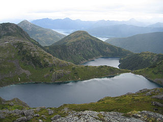
Ptarmigan Traverse is an alpine climbing route in the North Cascades of Washington state. The route, from Cascade Pass to Dome Peak, is generally remote, unmarked, and challenging, traversing rugged terrain and several glaciers.
Ptarmigan Traverse is an alpine climbing route in the North Cascades of Washington state. The route, from Cascade Pass to Dome Peak, is generally remote, unmarked, and challenging, traversing rugged terrain and several glaciers.
The first traverse took 13 days in July 1938. The group consisted of four members of the Ptarmigan Climbing Club: Bill Cox, Calder Bressler, Ray W. Clough, and Tom Myers. The second traverse was in 1953 and consisted of Dale Cole, Bob Grant, Mike Hane, Erick Karlsson and Tom Miller. Miller took high-quality photos of the peaks, valleys, glaciers, and lakes, which were later published in a book by The Mountaineers. The book, called The North Cascades, was published in 1964 and proved instrumental in the bid to create the North Cascades National Park.
The route is named after an alpine bird, the rock ptarmigan. The "p" is silent and is pronounced "TAR-mig-an".
The third successful traverse of the route was made in 1958 by a party led by photographer Ira Spring, with Coleman Leuthy, Ray and Marge McConnell, Peggy Stark and Russell Bockman. The trip was described in an article published in The Saturday Evening Post that was illustrated with Spring's stunning photos of the trip. Today the route is a common goal of Cascade Range mountaineers.
Place names are listed from north to south:
The Chugach Mountains of southern Alaska are the northernmost of the several mountain ranges that make up the Pacific Coast Ranges of the western edge of North America. The range is about 250 miles (402 km) long and 60 miles (97 km) wide, and extends from the Knik and Turnagain Arms of the Cook Inlet on the west to Bering Glacier, Tana Glacier, and the Tana River on the east. It is bounded on the north by the Matanuska, Copper, and Chitina rivers. The highest point of the Chugach Mountains is Mount Marcus Baker, at 13,094 feet (3,991 m), but with an average elevation of 4,006 feet (1,221 m), most of its summits are not especially high. Even so, its position along the Gulf of Alaska ensures more snowfall in the Chugach than anywhere else in the world, an annual average of over 1500 cm (800 in).

The Wenatchee Mountains are a range of mountains in central Washington State, United States of America. A major subrange of the Cascade Range, extending east 50 miles (80 km) from the Cascade crest, the Wenatchee Mountains separate the drainage basins of the Yakima River from the Wenatchee River. The crest of the range forms part of the boundary between Chelan and Kittitas Counties.
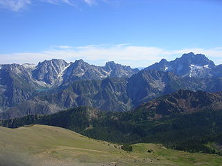
The Stuart Range is a mountain range in central Washington, United States. The range lies within the eastern extent of the Cascade Range immediately southwest of Leavenworth and runs east–west. The western peaks make up a single sharp ridge. The eastern half of the range splits into two parallel ridges, the northern of which is known as the Enchantment Peaks. Between these ridges lies the Enchantment Basin, which holds the dozens of tarns known as the Enchantment Lakes. Collectively, the basin and the encircling eastern peaks of the Stuart Range make up The Enchantments, a well-known backpacking destination. The south face of the Stuart Range falls off steeply to Ingalls Creek, beyond which rise the roughly parallel Wenatchee Mountains.

Mount Baker Wilderness is a 119,989-acre (48,558 ha) wilderness area within the Mount Baker-Snoqualmie National Forest in the western Cascade Range of northern Washington state. Its eastern border is shared with the boundary of the Stephen Mather Wilderness and North Cascades National Park for a distance of 40 miles. The wilderness extends from State Route 20 north to the Canada–US border. On the west, it is bounded by the foothills of the Puget Sound lowlands.

Dome Peak is a high, massive, glaciated mountain in the Glacier Peak Wilderness of Washington's North Cascades. The remote location of Dome Peak, combined with its height, make it a less common destination for Cascade Range mountaineers. Dome Peak is at the southern end of the Ptarmigan Traverse mountaineering route. It is located at the extreme southeast corner of Skagit County. The mountain was given its name by Albert H. Sylvester, the first forest supervisor of Wenatchee National Forest.

South Cascade Glacier is a large alpine glacier in the North Cascades of Washington, USA. It is bordered on the east by 8,261-foot (2,518 m) Sentinel Peak, and is about 17 mi (27 km) north of Glacier Peak in the Glacier Peak Wilderness. Meltwater from the glacier flows directly into South Cascade Lake, which feeds the South Fork Cascade River, which is a tributary of the Skagit River.

Sahale Mountain is a jagged, glaciated mountain, in North Cascades National Park, in northern Washington state. The summit of Sahale Mountain is referred to as Sahale Peak. It is 0.3 miles (0.48 km) south of its higher neighbor, Boston Peak, and the saddle between the two is 80 feet (24 m) lower than Sahale's summit. Quien Sabe Glacier is to the west of the ridge between the two peaks while Davenport Glacier is in a cirque east of this ridge and above Horseshoe Basin. Sahale Glacier is south of the summit and east of Sahale Arm, a ridge that extends southwest from Sahale to Cascade Pass. The name Sahale may originate from a Northwest Native American word meaning "high place," "falcon," or "sacred."

The canyons of the Teton Range lie almost entirely within Grand Teton National Park in the U.S. state of Wyoming. Ranging from 9 miles (14 km) to less than 1 mile (1.6 km) in length and up to 6,000 feet (1,800 m) deep, the canyons were carved primarily by glaciers over the past 250,000 years. The canyons in the Teton Range descend in altitude generally west to east and many have lakes at their outlets. The lakes were created by terminal moraines left behind by the now retreated glaciers. A few of the canyons have small glaciers that were created mostly during the Little Ice Age (1550-1850). Fast retreating Schoolroom Glacier is a tiny glacier located at the head of the South Cascade Canyon. Most of the canyons have streams from which rain and snowmelt flow towards Jackson Hole valley, and due to the sometimes rapid altitude descent, waterfalls are common. The canyons offer the easiest hiking access into the Teton Range.

Mount Logan is located in North Cascades National Park in the U.S. state of Washington. Mount Logan is in a remote location of North Cascades National Park that requires hiking 20 mi (32 km) from a trailhead to reach the peak. The mountain itself is not a difficult climb, though the easiest approaches require traversing glaciers and ropes are recommended. The peak supports three glaciers including Banded Glacier to the north, Fremont Glacier to the southwest and Douglas Glacier on the southeast slopes.

Mount Formidable is a mountain in the North Cascades of Skagit County, in Washington state. Its first ascent was undertaken by members of the original Ptarmigan Traverse, and the peak is a popular climb for parties on the traverse. It was named by early mountaineer Herman Ulrichs in 1935 because of the rugged appearance of its north face. The peak is usually accessed from Cascade Pass via the Ptarmigan Traverse.

Mix-up Peak, also known as Mixup Peak, is a 7,440-foot (2,270-metre) mountain summit located on the shared boundary of Skagit County and Chelan County in Washington state. It is part of the North Cascades Range and is situated one mile south of Cascade Pass on the shared border of North Cascades National Park and Glacier Peak Wilderness. The nearest higher peak is Magic Mountain, 1.02 miles (1.64 km) to the east-southeast. Mix-up Peak is at the northern end of the Ptarmigan Traverse which is an alpine route to remote mountains such as Mount Formidable and Dome Peak. The Cache Glacier occupies a cirque below its eastern flank. Surface runoff on the east side the mountain drains into the Stehekin River, whereas precipitation runoff drains into the Cascade River from the west side.

Le Conte Mountain is a 7,762-foot-elevation summit located on the shared boundary of Skagit County and Chelan County in Washington state. It is positioned on the crest of the North Cascades Range, and is set within the Glacier Peak Wilderness. Le Conte Mountain is situated on the shared border of Mount Baker-Snoqualmie National Forest and Okanogan-Wenatchee National Forest. Access to the peak is via the Ptarmigan Traverse. The nearest higher neighbor is Sentinel Peak, 1.87 miles (3.01 km) to the south-southeast, and Spider Mountain is 2.4 miles (3.9 km) to the northeast. The Le Conte Glacier and South Cascade Glacier lie to the south of the peak. Precipitation runoff on the east side the mountain drains into Flat Creek which is a tributary of the Stehekin River, while precipitation drains into headwaters of the South Fork Cascade River from the west side. Topographic relief is significant as the southwest aspect rises nearly 2,500 feet (762 meters) above South Cascade Lake in less than one-half mile, and the northeast aspect rises 3,200 feet above Flat Creek in one mile.