
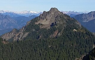
Tomyhoi Peak is a 7,439-foot (2,267-metre) Skagit Range mountain situated one mile south of the Canada–United States border, in the North Cascades of Washington state. It is located west of Mount Larrabee and within the Mount Baker Wilderness, which is part of the Mount Baker-Snoqualmie National Forest. This mountain's name was officially adopted in 1913 by the U.S. Board on Geographic Names.
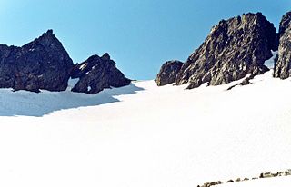
Cache Col is a gap in a high ridge between Magic Mountain and Mix-up Peak. It's located at the highest part of Cache Glacier, on the shared boundary of Skagit County and Chelan County in Washington state. Cache Col is situated south of Cascade Pass on the shared border of North Cascades National Park and Glacier Peak Wilderness. Cache Col and the Cache Glacier are at the northern end of the Ptarmigan Traverse which is mountaineering route that provides access to remote peaks such as Mount Formidable and Dome Peak. Precipitation runoff on the north side of the col drains into the Stehekin River, while precipitation drains into the Cascade River from the south side.

Mix-up Peak, also known as Mixup Peak, is a 7,440-foot (2,270-metre) mountain summit located on the shared boundary of Skagit County and Chelan County in Washington state. It is part of the North Cascades Range and is situated one mile south of Cascade Pass on the shared border of North Cascades National Park and Glacier Peak Wilderness. The nearest higher peak is Magic Mountain, 1.02 miles (1.64 km) to the east-southeast. Mix-up Peak is at the northern end of the Ptarmigan Traverse which is an alpine route to remote mountains such as Mount Formidable and Dome Peak. The Cache Glacier occupies a cirque below its eastern flank. Surface runoff on the east side the mountain drains into the Stehekin River, whereas precipitation runoff drains into the Cascade River from the west side.

Rainy Peak is a 7,768 ft (2,368 m) summit in the Cascade Range in the U.S. state of Washington. It is located 3 kilometers south of Rainy Pass and one kilometer southeast of Frisco Mountain on the borders of the Stephen Mather Wilderness and North Cascades National Park. Its nearest higher peak is Corteo Peak, 2.33 mi (3.75 km) to the northwest. Precipitation runoff from Rainy Peak drains into Rainy Lake and tributaries of Bridge Creek. The retreating Lyall Glacier in its north cirque contributes to waterfalls which tumble 1,000 ft (300 m) into Rainy Lake.

Hurry-up Peak is a 7,821-foot-elevation summit located on the shared boundary of Skagit County and Chelan County in Washington state. It is positioned on the crest of the North Cascades Range, and is set at the northern end of the Ptarmigan Traverse. Hurry-up Peak is situated southeast of Cascade Pass on the shared border of North Cascades National Park and Glacier Peak Wilderness. The nearest higher peak is Spider Mountain, 1.49 miles (2.40 km) to the south, with Magic Mountain 0.83 miles (1.34 km) to the north, and Trapper Mountain 0.7 miles (1.1 km) to the east. The S Glacier rests on the eastern flank of the peak and meltwater from it drains into Trapper Lake. Precipitation runoff on the east side the mountain drains into tributaries of the Stehekin River, while precipitation drains into the Cascade River from the west side. Ess Mountain and S Mountain are variant names for Hurry-up Peak. This geographical feature's name was officially adopted in 1969 by the U.S. Board on Geographic Names.

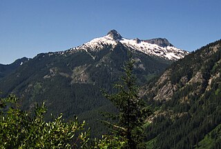
Snowking Mountain is a 7,433-foot (2,266-metre) summit located in Skagit County of Washington state. Situated within the Glacier Peak Wilderness, Snowking Mountain is positioned west of the crest of the North Cascades Range, approximately 18 miles northeast of the town of Darrington. It is set within the Glacier Peak Wilderness, on land managed by Mount Baker–Snoqualmie National Forest. Snowking has two subsidiary peaks, West Peak (7425 ft), and Middle Peak (7400 ft). A broad unnamed glacier known colloquially as Snowking Glacier rests on the north face. Downslope of that glacier are Snowking Lake, Found Lake, and Cyclone Lake. Mount Tommy Thompson is three miles to the northwest, and the nearest higher neighbor is Mount Misch, 5.75 miles (9.25 km) to the southeast. Precipitation runoff from Snowking Mountain drains into tributaries of the Skagit River.
Tricouni Peak is an 8,102-foot (2,469-metre) mountain summit located in Skagit County of Washington state. It is situated in North Cascades National Park, north of the North Klawatti Glacier and southeast of the Borealis Glacier. Its nearest higher peak is Primus Peak, 0.54 mi (0.87 km) to the west. Precipitation runoff from Tricouni drains into Thunder Creek. The peak is named for the tricouni which was used for traction on ice, and the approach to the peak involves traversing a glacier.

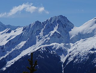
Buck Mountain is an 8,528-foot (2,599-metre) mountain summit located in the Glacier Peak Wilderness of the North Cascades in Washington state. The mountain is situated in Chelan County, in the Wenatchee National Forest. Its nearest higher peak is Clark Mountain, 3.98 mi (6.41 km) to the southwest, and Brahma Peak is set 1.8 mi (2.9 km) to the south. Precipitation runoff from it drains into Buck Creek, Chiwawa River, and Napeequa River, each a tributary of the Wenatchee River. The mountain's name was applied by Albert Hale Sylvester (1871-1944), a pioneer surveyor, explorer, topographer, and forest supervisor in the Cascades.
Kololo Peaks is an 8,200+ ft mountain located in the Glacier Peak Wilderness of the North Cascades in Washington state. The mountain is situated on the crest of the Cascade Range, on the shared border of Snohomish County and Chelan County, and also straddling the boundary between Mount Baker-Snoqualmie National Forest and Wenatchee National Forest. The nearest higher peak is Glacier Peak, 3.29 mi (5.29 km) to the north. Precipitation runoff and meltwater from the White River Glacier on the southeast slope drains into White River. On the west slope, the White Chuck Glacier drains into the White Chuck River, and the Suiattle Glacier and Honeycomb Glacier on the north and east sides drain into the Suiattle River. Surrounded by these glaciers, Fred Beckey in his Cascade Alpine Guide describes the mountain as being almost a nunatak.

Spider Mountain is an 8,286-foot (2,526-metre) mountain summit located in the Glacier Peak Wilderness in western Chelan County of Washington state. It is part of the North Cascades, which is a subset of the Cascade Range. Meltwater from the Spider Glacier on the steep north face, and other surface runoff from the mountain drains into Flat Creek, which is a tributary of the Stehekin River. The nearest higher neighbor is Mount Formidable 1.5 miles (2.4 km) to the west. The Middle Cascade Glacier lies between these two mountains, and the Ptarmigan Traverse passes through also.

Tupshin Peak is an 8,320+ ft mountain summit located in the Glacier Peak Wilderness of the North Cascades in Washington state. The mountain is situated in Chelan County, on land managed by Wenatchee National Forest. Its nearest higher peak is Devore Peak, 1.55 mi (2.49 km) to the south-southwest, and Bonanza Peak lies 6.71 mi (10.80 km) to the southwest. Precipitation runoff from the peak drains to nearby Lake Chelan via tributaries of the Stehekin River. The mountain's name comes from Chinook jargon and means "needle".

Glory Mountain is a 7,228-foot (2,203-metre) mountain summit located in the North Cascades Range in Chelan County of Washington state. Glory Mountain is situated southeast of Trapper Lake on the shared border of North Cascades National Park and Glacier Peak Wilderness. The nearest higher peak is Trapper Mountain, 1.72 miles (2.77 km) to the west. Precipitation runoff from the mountain drains into Cottonwood Creek and Flat Creek, both tributaries of the Stehekin River. An unofficially named secondary peak called Halleluja Peak 7,120+ ft lies 0.32 miles (0.51 km) to the west of the summit.
Mount Forgotten is a 6,005-foot-elevation (1,830-meter) mountain summit near the western edge of the North Cascades, in Snohomish County of Washington state. It is located five miles north of Barlow Pass along the Mountain Loop Highway near the Monte Cristo area and is situated on land administered by the Mount Baker-Snoqualmie National Forest. The nearest higher peak is Mount Pugh, 4.22 mi (6.79 km) to the northeast. Precipitation runoff from the mountain drains into tributaries of the Sauk River.

Devore Peak is an 8,360+ ft mountain summit located in the Glacier Peak Wilderness of the North Cascades in Washington state. The mountain is situated in Chelan County, on land managed by Wenatchee National Forest. Its nearest higher peak is Martin Peak, 3.36 mi (5.41 km) to the southwest, and Tupshin Peak lies 1.55 mi (2.49 km) to the north-northeast. Precipitation runoff from the peak drains to nearby Lake Chelan via tributaries of the Stehekin River and Devore Creek.

Pelton Peak is a 7,132-foot (2,174-metre) mountain summit located in Chelan County of Washington state. It is part of the North Cascades, a subset of the Cascade Range. Pelton Peak is situated 1.8 miles (2.9 km) southeast of Cascade Pass in North Cascades National Park near the northern end of the Ptarmigan Traverse. The nearest higher peak is Magic Mountain, 0.4 miles (0.64 km) to the southwest. The Yawning Glacier rests on its western flank between these two peaks. Surface runoff from the mountain drains into tributaries of the Stehekin River. The mountain's name comes from the Pelton wheel which was used in early mining times, and several mines were located in the vicinity of Pelton Basin, Horseshoe Basin, and Boston Basin.

Brahma Peak is a remote 8,078-foot (2,462-metre) mountain summit located on Chiwawa Ridge in the North Cascades, in Chelan County of Washington state. The mountain is situated in the Glacier Peak Wilderness, on land managed by the Wenatchee National Forest. Its nearest higher neighbor is Buck Mountain, 1.8 mi (2.9 km) to the north. Brahma and Buck are set on Chiwawa Ridge, and other notable peaks on this ridge include Fortress Mountain, Cirque Mountain, Napeequa Peak, Mount Berge, Bandit Peak, and Chiwawa Mountain. Precipitation runoff from Brahma and meltwater from its glacier remnants drains into Chiwawa River and Napeequa River, both tributaries of the Wenatchee River. Topographic relief is significant since the southwest lavender-colored schist cliffs of this peak rise nearly 4,000 feet above the Napeequa River Valley in approximately one mile.

Cirque Mountain is a 7,966-foot (2,428-metre) mountain summit located in the Glacier Peak Wilderness of the North Cascades in Washington state. The mountain is situated on the crest of the Cascade Range, on the shared border of Snohomish County and Chelan County, also straddling the boundary between the Mount Baker-Snoqualmie National Forest and the Wenatchee National Forest. Its nearest higher peak is Napeequa Peak, 0.3 mi (0.48 km) to the south. The peak is set on Chiwawa Ridge with Napeequa, and other notable peaks on this ridge include Fortress Mountain, Buck Mountain, Brahma Peak, Mount Berge, and Chiwawa Mountain. Topographic relief is significant since the western aspect of the mountain rises 4,000 feet above the Suiattle Valley in approximately 1.5 mi (2.4 km). This mountain has small, unnamed, hanging glaciers in cirques surrounding the summit. Precipitation runoff from the peak and meltwater from the glaciers drains east to the headwaters of Napeequa River; or west into the Suiattle River.

Morning Star Peak is a 6,020 ft (1,830 m) mountain summit located near the western edge of the North Cascades, in Snohomish County of Washington state. It is situated 2.5 mi (4.0 km) southwest of Barlow Pass along the Mountain Loop Highway near the Monte Cristo area. It is set on land managed by Mount Baker-Snoqualmie National Forest. The nearest higher neighbor is Sperry Peak, 1 mile (1.6 km) to the northwest. Precipitation runoff from the south side of the mountain drains into the Sultan River, and the north side drains into headwaters of the Stillaguamish River. July through September offer the most favorable weather for climbing this mountain.

Bandit Peak is a 7,625-foot (2,324-metre) double-summit granitic mountain located in the Glacier Peak Wilderness of the North Cascades, in Chelan County of Washington state. The mountain is situated east of the crest of the Cascade Range, on land managed by the Okanogan–Wenatchee National Forest. Its nearest higher neighbor is Brahma Peak, 5.9 mi (9.5 km) to the north. Bandit Peak is the ninth-highest peak on Chiwawa Ridge, and other notable peaks on this ridge include Mount Berge, Buck Mountain, Cirque Mountain, Napeequa Peak, Helmet Butte, and Chiwawa Mountain. Precipitation runoff from Bandit Peak drains west into Napeequa River; or east into the Chiwawa River.
Mount David is a prominent 7,420-foot (2,260-metre) mountain summit located in Chelan County of Washington state. The mountain is situated in the Glacier Peak Wilderness, on land managed by the Okanogan-Wenatchee National Forest. Mount David is the highest point of Wenatchee Ridge, a subrange which also includes Indian Head Peak, Whittier Peak, Mount Saul, and Mount Jonathan. Its nearest higher neighbor is Bandit Peak, 5.69 mi (9.16 km) to the east-northeast. Precipitation runoff from Mount David drains into tributaries of the White River. Although modest in elevation, relief is significant since Mt. David rises 5,100 feet above the White River Valley in two miles. This peak was named for the biblical David by Albert Hale Sylvester, a pioneer surveyor, explorer, topographer, and forest supervisor in the Cascades who named thousands of natural features. This mountain can be climbed via the strenuous seven-mile Mount David Trail with over 5,000 feet of elevation gain.


