Queen Louise Land

Last updated
Queen Louise Land
Nuna Dronning Louise
Dronning Louise Land
Queen Louise Land ONC B-9.jpg
Queen Louise Land ONC map section.
Highest point
Peak Gefiontinde
Elevation 2,364 m (7,756 ft)
Dimensions
Length185 km (115 mi)N/S
Width73 km (45 mi)E/W
Area12,000 km2 (4,600 sq mi)
Geography
Greenland edcp relief location map.jpg
Red triangle with thick white border.svg
Location
Country Greenland
Range coordinates 76°40′N24°30′W / 76.667°N 24.500°W / 76.667; -24.500
Geology
Orogeny Caledonian orogeny [1]

Queen Louise Land (Danish : Dronning Louise Land; [2] Greenlandic : Nuna Dronning Louise) [3] is a vast mountainous region located west of Dove Bay, King Frederik VIII Land, northeastern Greenland. Administratively it is part of the Northeast Greenland National Park zone.

Contents

The highest point of Queen Louise Land is Gefiontinde, [4] with a height of 2,364.3 m (7,757 ft), the highest of the Gefiontinder group of peaks located at 76°28′8″N25°38′31″W / 76.46889°N 25.64194°W / 76.46889; -25.64194 . [5] [6]

Geologically Queen Louise Land is made up of orthogneiss overlain by sedimentary rocks. [7]

History

This remote area was named Dronning Louises Land after Queen Louise of Denmark (1851–1926), wife of King Frederik VIII of Denmark, [8] by the ill-fated 1906–08 Denmark Expedition —the expedition that aimed to map one of the last unknown parts of Greenland. [9] Danish Arctic explorer Alf Trolle claimed that this area had been originally named as Den Store Nanuták —The Big Nunatak. [10]

Queen Louise Land was subsequently visited by the 1912–13 Danish Expedition to Queen Louise Land led by J.P. Koch, [8] as well as the 1952–54 British North Greenland Expedition led by Commander James Simpson. [11]

Geography

Surrounded by ice masses, Queen Louise Land is clearly delimited. It is an extensive area made up of several very large and numerous small nunataks (summits or ridges of mountains that protrude from the ice). Its western boundary is the Greenland ice sheet and its eastern limits are the massive Storstrommen and L. Bistrup Brae glaciers. Kap Aage Bertelsen is a small headland at the confluence of the large Storstrømmen and L. Bistrup Bræ glaciers in the east. Dryasdal is a valley seasonally covered with Dryas octopetala flowers. The area of Queen Louise Land is uninhabited. [5]

The main geographic divisions or parts of Queen Louise Land from north to south are:

Queen Louise Land and neighbouring areas NASA picture. Dronning Louise Land-NE Greenland.jpg
Queen Louise Land and neighbouring areas NASA picture.

Glaciers, ice caps, lakes and rivers

Mountains, nunataks and cliffs

Many of the mountains and massifs are little glaciated. Mountains are generally rounded and rarely craggy, but there are numerous cliffs. The average elevation is around 1,500 m. [8]

Bibliography

See also

Related Research Articles

<span class="mw-page-title-main">Lindhard Island</span>

Lindhard Island is an uninhabited island of NE Greenland.

<span class="mw-page-title-main">Waltershausen Glacier</span>

Waltershausen Glacier is one of the major glaciers in Greenland. It has its terminus on the east coast of the Greenland ice sheet.

<span class="mw-page-title-main">Storstrommen (Greenland)</span>

Storstrommen, is one of the major glaciers in northeastern Greenland. The North-East Greenland Ice Stream (NEGIS) discharges into 3 main marine-terminating outlets: 79N Glacier, Zachariae Isstrøm and Storstrommen - as arranged North to South.

<span class="mw-page-title-main">King Frederik VIII Land</span> Region in Greenland

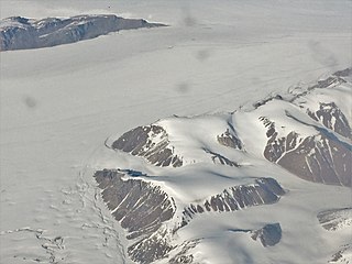
King Frederik VIII Land is a major geographic division of northeastern Greenland. It extends above the Arctic Circle from 76°N to 81°N in a North-South direction along the coast of the Greenland Sea.

<span class="mw-page-title-main">Revaltoppe</span> Mountain in Greenland

Revaltoppe is one of the highest mountains in Queen Louise Land, NE Greenland. The peak is located in the King Frederick VIII Land area of northeastern Greenland. Administratively it is part of the Northeast Greenland National Park zone.

<span class="mw-page-title-main">Gefiontinde</span>

Gefiontinde is the highest mountain in Queen Louise Land, NE Greenland. The peak is located in the King Frederick VIII Land area of northeastern Greenland. Administratively it is part of the Northeast Greenland National Park zone.

<span class="mw-page-title-main">Academy Glacier (Greenland)</span> Glacier in Greenland

Academy Glacier, is one of the major glaciers in northern Greenland.

<span class="mw-page-title-main">Denmark expedition</span> 1906-1908 Expedition to northeastern Greenland

The Denmark expedition, also known as the Denmark Expedition to Greenland's Northeast Coast and the Danmark Expedition after the ship's name, was an expedition to northeastern Greenland in 1906–1908.

C. H. Ostenfeld Glacier, is one of the major glaciers in northern Greenland.

<span class="mw-page-title-main">Adolf Hoel Glacier</span> Glacier in Greenland

Adolf Hoel Glacier, also known as Hoel Glacier(Hoels Gletscher), is one of the major glaciers in King Christian X Land, Northeast Greenland. Administratively it lies in the Northeast Greenland National Park zone.

<span class="mw-page-title-main">Britannia Lake</span> Lake in Queen Louise Land

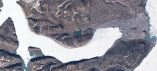
Britannia Lake, is a lake in King Frederik VIII Land, Northeastern Greenland. The lake and its surroundings are part of the Northeast Greenland National Park zone.

<span class="mw-page-title-main">Britannia Glacier</span> Glacier in northeastern Greenland

Britannia Glacier is a glacier in Queen Louise Land, northeastern Greenland. Administratively it belongs to the Northeast Greenland National Park.

<span class="mw-page-title-main">Admiralty Glacier</span> Glacier in northeastern Greenland

Admiralty Glacier is a glacier in Queen Louise Land, northeastern Greenland. Administratively it belongs to the Northeast Greenland National Park.

<span class="mw-page-title-main">Ad Astra Ice Cap (Greenland)</span> Ice cap in northeastern Greenland

Ad Astra Ice Cap is an ice cap in Queen Louise Land, northeastern Greenland. Administratively it belongs to the Northeast Greenland National Park.

<span class="mw-page-title-main">Eventyrfjelde</span>

Eventyrfjelde is a group of nunataks in Queen Louise Land, NE Greenland. Administratively it is part of the Northeast Greenland National Park zone.

<span class="mw-page-title-main">L. Bistrup Brae</span> Glacier in northeastern Greenland

L. Bistrup Brae is a glacier in Northeastern Greenland. Administratively it belongs to the Northeast Greenland National Park.

<span class="mw-page-title-main">Carlsbergfondet Land</span>

Carlsbergfondet Land is a group of nunataks in Queen Louise Land, NE Greenland. Administratively it is part of the Northeast Greenland National Park zone.

<span class="mw-page-title-main">Borgjokel</span> Glacier in northeastern Greenland

Borgjokel is a glacier in Queen Louise Land, northeastern Greenland. Administratively it belongs to the Northeast Greenland National Park.

<span class="mw-page-title-main">Danish Expedition to Queen Louise Land</span> Danish expedition to North Greenland

The Danish Expedition to Queen Louise Land, also known as the Danish expedition to Queen Louise Land and straight through Greenland’s ice sheet, as well as Danish North Greenland Expedition, was an expedition to northeastern Greenland and across the Greenland ice sheet in 1912–1913. It was the first such venture that went across the broad central part of Greenland. The expedition was led by Johan Peter Koch (1870–1928). Its purpose was to study the vast ice sheet, making glaciological and meteorological observations. Instead of sled dogs, sixteen Icelandic ponies were chosen for transporting 20 tons of materials, including 6 t of compressed hay to feed the ponies.

References

  1. Regional Caledonian structure within an oblique convergence zone, Dronning Louise Land, NE Greenland, Journal of the Geological Society
  2. "Dronning Louise Land". Mapcarta. Retrieved 2 July 2016.
  3. Den grønlandske Lods - Geodatastyrelsen
  4. 1 2 3 4 GEUS Map - Northern East Greenland; Geological Survey of Denmark and Greenland Bulletin 21 Map 4 - 1:1 000 000
  5. 1 2 Google Earth
  6. Greenland Expedition - Dronning Louise Land
  7. Harold Williams, Geology of the Appalachian—Caledonian Orogen in Canada and Greenland, p. 896]
  8. 1 2 3 "Catalogue of place names in northern East Greenland". Geological Survey of Denmark. Retrieved 2 July 2016.
  9. The Wegener Diaries: Scientific Expeditions into the Eternal Ice
  10. Trolle, A. 1909: The Danish North-East Greenland Expedition. Journal of the Royal Geographical Society 25, 57–70.
  11. British North Greenland Expedition, 1952–54 - Cambridge Journals