Regions of Singapore

Last updated
Regions of Singapore
Singapore Planning Regions.png
Category Unitary state
LocationFlag of Singapore.svg  Singapore
Created by Urban Redevelopment Authority
Created
  • September 1991 (proposed) [1]
  • 22 January 1999 (gazetted) [2]
Number5 (as of 2019)
Populations582,330 (North Region)

930,910 (North-East Region) [3]
Areas93.1 km2 (35.9 sq mi) (East Region)

201.3 km2 (77.7 sq mi) (West Region) [3]
Government
Subdivisions

The regions of Singapore are urban planning subdivisions demarcated by the Urban Redevelopment Authority of Singapore to aid in its planning efforts. Over time, other governmental organisations have also adopted the five regions in their administrative work, as for example the Department of Statistics in the census of 2000. The regions are further subdivided into 55 planning areas, which include two water-catchment areas. The largest region in terms of area is the West Region with 201.3 km2 (77.7 sq mi), while the Central Region is the most populous with an estimated population of 922,980 inhabitants in the area in 2019. [3]

Contents

While used by some governmental organizations, these regions are not administrative subdivisions. For administrative purposes, Singapore is divided into five districts and further divided into divisions governed by councils and headed by mayors. These subdivisions are incompatible with the regional subdivisions. The regions are fixed over time while the districts fluctuate with electoral redistricting.

Regional centres

Prior to 1991, urban planners in Singapore preferred to have a strong commercial zone in the centre of the metropolitan area. Coupled with a disjointed residential developments in the northern and eastern areas, and industrial developments in the western areas of Singapore, this resulted in citizens having to travel across the island to their work or retail destinations. Addressing the transportation issue, the concept of regional centres was introduced in 1991 with the 1991 Master Plan. [4] [5]

Internationally, regional centres are typically new urban places or self-contained independent cities with their own mix of urban functions. [4] [5] However, as the land mass of Singapore is small, the term, regional centre, takes on a localised meaning: a functional node that is designed to serve as a smaller-scale downtown area between town centres in new residential towns and the main central business district in the Central Area. These centres are planned to offer a variety of commercial, retail, entertainment, and other amenities to residents in the surrounding areas. They are strategically located in areas that are well-served by the Mass Rapid Transit system, an efficient bus system, and an extensive road network. [5] These regional centres are aimed to decentralised the amenities that's previously concentrated in the city's core.

There are four regional centres in Singapore, which were identified in the 1991 Master Plan. [4] The first regional centre to be developed was Tampines Regional Centre, located in the East Region, Singapore, along with the introduction of the 1991 Master Plan. Subsequently, Jurong East Regional Centre (West Region, Singapore), also known as the Jurong Lake District, was being developed next in 2008, [6] with renewed plans unveiled in 2023. [7] Woodlands Regional Centre (WRC) (North Region, Singapore) was mooted in 2014. [6] [8] In addition to the existing road and rail link on the Johor–Singapore Causeway, WRC would be connected to the neighbouring Johor Bahru city in Malaysia via the Johor Bahru–Singapore Rapid Transit System by 2026. [9] Lastly, plans for Seletar Regional Centre (North-East Region, Singapore) has yet to be unveiled. [10]

List of regions

Population figures are as of 30 June 2020. They include citizens and permanent residents but do not include the approximately 1.6 million non-permanent residents of Singapore.

Region [3] Regional centreLargest PA by areaLargest PA by populationArea
(km2)
Estimated

Population

Population
density
(/km2)
Planning
Areas
Central Region Central Area (de facto) Queenstown Bukit Merah 132.7922,5806,95222
East Region Tampines Changi Bedok 93.1685,8907,3676
North Region Woodlands Central Water Catchment Woodlands 134.5582,3304,3308
North-East Region Seletar North-Eastern Islands Sengkang 103.9930,9108,9609
West Region Jurong East Western Water Catchment Jurong West 201.3922,5404,58312
Total665.54,044,2506,07755

See also

Related Research Articles

<span class="mw-page-title-main">Transport in Singapore</span>

Transportation in Singapore is predominantly land-based, with a comprehensive network of roads making many parts of the city-state, including islands such as Sentosa and Jurong Island, accessible. The road network is complemented by a robust rail system consisting of the Mass Rapid Transit (MRT) and the Light Rail Transit (LRT), which cover the length and width of Singapore and serve a few neighbourhoods respectively. The main island of Singapore is also connected to other islands via ferryboat services. Furthermore, the city-state maintains strong international connections through two bridges linking it to Malaysia – the Causeway and the Second Link – and the Singapore Changi Airport, a major aviation hub in Asia.

<span class="mw-page-title-main">Johor Bahru</span> State capital city and district capital in Johor, Malaysia

Johor Bahru, colloquially referred to as JB, is the capital city of the state of Johor, Malaysia and the core city of Johor Bahru District, the second largest district in Malaysia by population. It is the second-largest GDP contributor among all major cities in Malaysia, and forms a part of Iskandar Malaysia, the nation's largest special economic zone by investment value. The city has a population of 858,118 people within an area of 391.25 km2.

<span class="mw-page-title-main">Woodlands, Singapore</span> Planning Area and Regional Centre in North Region, Singapore

Woodlands is a planning area and residential town located in the North of Singapore. As of 2019, the town has a population of 254,733. Located approximately 25 km (16 mi) north of the central business district (CBD), it is the densest planning area and is the regional centre for the northern parts of the country.

<span class="mw-page-title-main">Geography of Singapore</span>

Singapore is an island city-state and country in maritime Southeast Asia, located at the end of the Malayan Peninsula between Malaysia and Indonesia as well as the Straits of Malacca and the South China Sea. It is heavily compact and urbanised. As of 2023, Singapore has a total land area of 734.3 square kilometres (283.5 sq mi). Singapore is separated from Indonesia by the Singapore Strait and from Malaysia by the Straits of Johor.

<span class="mw-page-title-main">Tampines</span> Planning area and regional centre in East Region, Singapore

Tampines is the regional centre of the East Region of Singapore. With a population of 265,340 living across its five subzones, it is the second-most populous planning area in Singapore, according to the DOS Population Trends 2022. It is home to approximately 5% of Singapore's population. Tampines is bordered to the west by Bedok and Paya Lebar, to the north by Pasir Ris, to the east by Changi, and to the south by the Straits of Singapore. Situated in the historical region of Tanah Merah, its present-day terrain is particularly flat due to the large-scale sand quarrying in the 1960s.

<span class="mw-page-title-main">Seletar</span> Planning Area and Regional Centre in North-East Region ----, Singapore

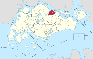
Seletar is an area located in the north-east of Singapore. Its name can also refer to the Seletar Planning Area, situated in the North-East Region of Singapore. The place name was derived from the Malay subgroup who were indigenous to the area, the Orang Seletar. It shares boundaries with the planning areas of Sengkang to the south, Punggol to the east, Yishun and Simpang to the west, as well as the Straits of Johor to the north.

<span class="mw-page-title-main">Pan Island Expressway</span> Road in Singapore

The Pan Island Expressway is the oldest and longest expressway in Singapore. It is also Singapore's longest road. The expressway runs from the East Coast Parkway near Changi Airport in the east to Tuas in the west and has a total length of 42.8 kilometres (26.6 mi).

<span class="mw-page-title-main">North Region, Singapore</span> Region in Singapore

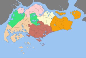
The North Region of Singapore is one of the five regions in the city-state. The region is the second largest region in terms of land area, and has a population of 582,330. Woodlands is the regional centre and also the most populous town with 255,130 residents living in the area. Comprising 13,500 hectares of land area, it includes eight planning areas.

Urban planning in Singapore is the direction of infrastructure development in Singapore. It is done through a three-tiered planning framework, consisting of a long-term plan to plot out Singapore's development over at least 50 years, a Master Plan for the medium term, and short-term plans, the first two of which are prepared by the Urban Redevelopment Authority (URA) and the last by multiple agencies.

<span class="mw-page-title-main">Rail transport in Singapore</span> Overview of rail transport in Singapore

Rail transport in Singapore mainly consists of a passenger urban rail transit system spanning the entire city-state: a rapid transit system collectively known as the Mass Rapid Transit (MRT) system operated by the two biggest public transport operators SMRT Trains and SBS Transit, as well as several Light Rail Transit (LRT) rubber-tyred automated guideway transit lines also operated by both companies. In addition, local specialised light rail lines are in operation in places such as the Singapore Changi Airport and Sentosa.

<span class="mw-page-title-main">West Region, Singapore</span> Region in Singapore

The West Region of Singapore is one of the five regions in the city-state. The region is the largest in terms of land area and is the third most populous region after the North-East Region and Central Region. Jurong East is the regional centre of the region, with plans of developing the Jurong Lake District into a second CBD area. Jurong West is the most populous town in the region, with a population of 262,730 residents. Comprising 25,500 hectares of land area, it includes twelve planning areas and is home to about 922,540 residents.

<span class="mw-page-title-main">Iskandar Puteri</span> City in Johor, Malaysia

Iskandar Puteri is a city and the administrative capital of the state of Johor, Malaysia. It hosts Kota Iskandar, which represents the seat of government of the state of Johor. Situated along the Straits of Johor at the southern end of the Malay Peninsula, it is also the southernmost city in Peninsular Malaysia.

<span class="mw-page-title-main">East Region, Singapore</span> Region in Singapore

The East Region of Singapore is one of the five regions in the city-state. The region is the 2nd most densely populated among the five, and has the smallest land area. Bedok is the region's most populous town and Tampines is the regional centre of the area. Comprising 11,000 hectares, it includes six planning areas and is also home to Singapore's Changi Airport and Paya Lebar Air Base.

<span class="mw-page-title-main">Our Tampines Hub</span> Integrated community and lifestyle hub

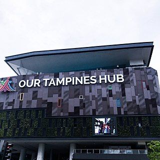
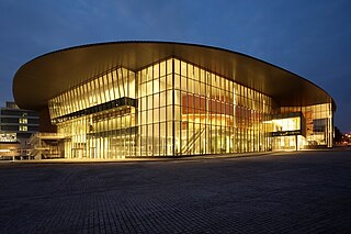
Our Tampines Hub is an integrated community and lifestyle building in Tampines, Singapore. It is located on the grounds of the former Tampines Stadium and Tampines Sports Hall and is part of the development of the Tampines Regional Centre.

<span class="mw-page-title-main">Future developments in Singapore</span>

This article shows the notable future developments in Singapore. Most of them are currently under construction with most to be completed within the next five years.

<span class="mw-page-title-main">Iskandar Malaysia</span> Growth corridor and metropolitan area in Johor, Malaysia

Iskandar Malaysia, formerly known as Iskandar Development Region (IDR; Malay: Wilayah Pembangunan Iskandar) and South Johor Economic Region (SJER), is the main southern development corridor in Johor, Malaysia. It was established on 8 November 2006. Iskandar Malaysia, which is formed by major cities such as Johor Bahru, Iskandar Puteri and Pasir Gudang, is part of the Johor Bahru Conurbation. It also lies within the original Indonesia–Malaysia–Singapore growth triangle, along with Singapore and Riau, Indonesia.

<span class="mw-page-title-main">Kuala Lumpur–Singapore high-speed rail</span> Proposed high speed rail project

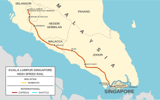
The Kuala Lumpur–Singapore high-speed rail (HSR) is a proposed railway project to link Kuala Lumpur, Malaysia to Singapore via a high-speed rail line. It was first proposed by then Malaysian Prime Minister Najib Razak in September 2010. Singapore Prime Minister Lee Hsien Loong formally agreed to the joint project in February 2013, with the HSR originally expected to be completed by 2026.

<span class="mw-page-title-main">Johor Bahru–Singapore Rapid Transit System</span> Cross-border rapid transit system

The Johor Bahru–Singapore Rapid Transit System (RTS) Link is an international cross-border rapid transit system that will connect Malaysia's second largest city, Johor Bahru and Woodlands, Singapore, crossing the Strait of Johor. It will consist of two stations, with the Malaysian terminus at Bukit Chagar station and the Singaporean terminus at Woodlands North station, which also interchanges with Singapore's Thomson–East Coast MRT line.

References

  1. "HistorySG - 1991 Concept Plan is unveiled". National Library Board.
  2. "Singapore Infopedia - Development guide plan". National Library Board.
  3. 1 2 3 4 2019 City Population - statistics, maps and charts | SINGAPORE: Regions Retrieved April 5, 2020.
  4. 1 2 3 Sim, Loo Lee; Malone-Lee, Lai Choo; Chin, Kein Hoong Lawrence (2001-09-01). "Integrating land use and transport planning to reduce work-related travel:: a case study of Tampines Regional Centre in Singapore". Habitat International. 25 (3): 399–414. doi:10.1016/S0197-3975(01)00012-1. ISSN   0197-3975.
  5. 1 2 3 Malone-Lee, Lai Choo; Sim, Loo Lee; Chin, Lawrence (2001-02-01). "Planning for a more balanced home–work relationship: the case study of Singapore". Cities. 18 (1): 51–55. doi:10.1016/S0264-2751(00)00056-1. ISSN   0264-2751.
  6. 1 2 "Tampines, the forgotten regional centre? Not for long". TODAY. Retrieved 2023-03-04.
  7. "Beyond 2022: How Singapore's development will affect the property market (Jurong East and Tengah)". AsiaOne. 2023-02-26. Retrieved 2023-03-04.
  8. Auto, Hermes (2017-04-16). "Woodlands to transform into 'star destination of the North' with new housing, recreational and business facilities | The Straits Times". www.straitstimes.com. Retrieved 2023-03-04.
  9. "JB-Singapore RTS Link project on track to start operations by end-2026". CNA. Retrieved 2023-03-04.
  10. "How Well Do Regional Centre Properties Compare Against The CBD?". Property Blog Singapore - Stacked Homes. 2020-08-22. Retrieved 2023-03-04.