The bridge, which is Grade I listed,[3] was built between 1774 and 1777, as a replacement for a ferry crossing which connected Richmond town centre on the east bank with its neighbouring district of East Twickenham to the west. Its construction was privately funded by a tontine scheme, for which tolls were charged until 1859. Because the river meanders from its general west to east direction, flowing from southeast to northwest in this part of London, what would otherwise be known as the north and south banks are often referred to as the "Middlesex" (Twickenham) and "Surrey" (Richmond) banks respectively, named after the historic counties to which each side once belonged.
The bridge was widened and slightly flattened in 1937–40, but otherwise still conforms to its original design. The eighth Thames bridge to be built in what is now Greater London, it is today the oldest surviving Thames bridge in London.
Background
The small town of Sheen on the Surrey bank of the Thames, 10 miles (16km) west of the City of London or 16 miles (26km) by river, had been the site of a royal palace since 1299. After it was destroyed by fire in 1497, Henry VII built a new palace on the site, naming it Richmond Palace after his historic title of Earl of Richmond, and the central part of Sheen became known as Richmond.[4]
Richmond, Twickenham Park and the route of the Richmond Ferry in 1746
Although a ferry had almost certainly existed at the site of the present-day bridge since Norman times,[5] the earliest known crossing of the river at Richmond dates from 1439.[6] The service was owned by the Crown, and operated by two boats, a small skiff for the transport of passengers and a larger boat for horses and small carts;[4] the Twickenham Ferry, slightly upstream, was also in service from at least 1652.[7] However, due to the steepness of the hill leading to the shore-line on the Surrey side neither ferry service was able to transport carriages or heavily laden carts,[8] forcing them to make a very lengthy detour via Kingston Bridge.[4]
In the 18th century Richmond and neighbouring Twickenham on the opposite bank of the Thames, both of which were distant from London but enjoyed efficient transport links to the city via the river, became extremely fashionable, and their populations began to grow rapidly.[4] As the ferry was unable to handle large loads and was often cancelled due to weather conditions, the river crossing became a major traffic bottleneck.[9]
Local resident William Windham had been sub-tutor to Prince William, Duke of Cumberland, and was the former husband of Mary, Lady Deloraine, mistress to George II.[10] As a reward for his services, George II leased Windham the right to operate the ferry until 1798.[10][11] Windham sub-let the right to operate the ferry to local resident Henry Holland.[10] With the ferry unable to serve the demands of the area, in 1772 Windham sought parliamentary approval to replace the ferry with a wooden bridge, to be paid for by tolls.[4]
Design
The plans for a wooden bridge proved unpopular, and in 1772 the Richmond Bridge Act was passed by Parliament, selecting 90 commissioners, including landscape architect Lancelot "Capability" Brown, historian and politician Horace Walpole and playwright and actor David Garrick, to oversee the construction of a stone bridge on the site of the ferry. The Act stipulated that no tax of any sort could be used to finance the bridge, and fixed a scale of tolls, ranging from ½d for a pedestrian to 2s6d for a coach drawn by six horses (about 50p and £17 respectively in 2024).[12][13] Henry Holland was granted £5,350 (about £723,300 in 2024) compensation for the loss of the ferry service.[12][13] The commission appointed James Paine and Kenton Couse to design and build the new bridge.[14]
Richmond Bridge
The Act specified that the bridge was to be built on the site of the existing ferry "or as much lower down the river as the Commission can settle".[12] Local residents lobbied for it to be built at Water Lane, a short distance downstream from the ferry site. The approach to the river was relatively flat, avoiding the steep slope to the existing ferry pier on the Surrey bank. However, the Dowager Duchess of Newcastle refused to allow the approach road on the Middlesex bank to pass through her land at Twickenham Park,[14] and the commission was forced to build on the site of the ferry, despite a steep 1 in 16 (6.25%) incline.[15]
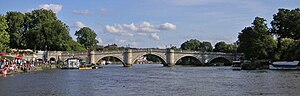
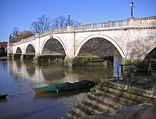
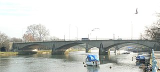
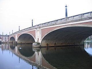
The bridge was designed as a stone arch bridge of 300 feet (91m) in length[16] and 24feet 9inches (7.54m) in width,[17] supported by five elliptical arches of varying heights. The tall 60-foot (18m) wide central span was designed to allow shipping to pass, giving Richmond Bridge a distinctive humpbacked appearance.[18] It was built in Portland stone,[15] and ran between Ferry Hill (Bridge Street today) on the Surrey side and Richmond Road on the Middlesex side; sharp curves in the approach roads on the Middlesex side (still in existence today) were needed to avoid the Dowager Duchess of Newcastle's land at Twickenham Park.[14]Palladiantoll houses were built in alcoves at each end.[14]
Construction
The milestone at the Surrey end of the bridge
The building was put out to tender, and on 16 May 1774 Thomas Kerr was awarded the contract to build the bridge for the sum of £10,900 (about £1.46million in 2024).[19][13] With additional costs, such as compensating landowners and building new approach roads, total costs came to approximately £26,000 (about £3.52million in 2024).[20][13]
Most of the money needed was raised from the sale of shares at £100 each (approximately £13,500 in 2024) in two tontine schemes, the first for £20,000 and the second for £5,000. The first was appropriately called the Richmond-Bridge Tontine,[20][13] but when it became clear that the initial £20,000 would not be sufficient to complete construction a second tontine was set up.[21] Each investor was guaranteed a return of 4% per annum, so £1,000 per annum from the income raised from tolls was divided amongst the investors in the two tontines. On the death of a shareholder their share of the dividend was divided among the surviving shareholders.[14] To avoid fraud, each investor was obliged to sign an affidavit that they were alive before receiving their dividend.[19][n 1] Any revenue over the £1,000 per annum required to pay the investors was held in a general fund for the maintenance of the bridge.[21]
Construction began on 23 August 1774.[20] The Prince of Wales was invited to lay the first stone but declined, and so the stone was laid by commission member Henry Hobart.[22] The bridge opened to pedestrians in September 1776 and to other traffic on 12 January 1777, at which time the ferry service was closed,[14] although work on the bridge was not completed until December 1777.[20] A large milestone was placed at the Richmond end, giving the distances to other bridges and to local towns.[23]
Operation
There was no formal opening ceremony, and little initial recorded public reaction.[23] However, the bridge soon became much admired for its design; an article in The London Magazine in 1779 said that the bridge was "a simple, yet elegant structure, and, from its happy situation, is ... one of the most beautiful ornaments of the river ... from whatever point of view the bridge is beheld, it presents the spectator with one of the richest landscapes nature and art ever produced by their joint efforts, and connoisseurs in painting will instantly be reminded of some of the best performances of Claude Lorraine".[24] James Paine proudly illustrated it among the designs in the second volume of his Plans, Elevations, and Sections of Noblemen and Gentlemen's Houses, 1783.[25] Richmond Bridge was the subject of paintings by many leading artists, including Thomas Rowlandson, John Constable and local resident J. M. W. Turner.[14]
Severe penalties were imposed for vandalising the bridge. The Richmond Bridge Act 1772 specified that the punishment for "willful or malicious damage" to the bridge should be "transportation to one of His Majesty's Colonies in America for the space of seven years". A warning against damage can still be seen on the milestone at the Surrey end of the bridge.[14]
Richmond Bridge was a commercial success, generating £1,300 per annum in tolls (about £98,130 in 2024) in 1810.[20][13] By 1822, the company had accumulated a sufficient surplus that all vehicle tolls were reduced to one penny.[26]
Alcove on the site of a former tollbooth
On 10 March 1859 the last subscriber to the main tontine died, having for over five years received the full £800 per annum set aside for subscribers to the first tontine, and with the death of its last member the scheme expired.[27][n 2] On 25 March 1859 Richmond Bridge became toll-free.[28] A large procession made its way to the bridge, where a team of labourers symbolically removed toll gates from their hinges.[28] The toll houses were demolished, replaced by seating in 1868; investment income from the revenue accumulated during the 83years the tolls had been charged was sufficient to pay for the bridge's maintenance.[14]
In 1846 the first railway line reached Richmond. Richmond gasworks opened in 1848, and Richmond began to develop into a significant town.[29] The District Railway (later the District line) reached Richmond in 1877, connecting it to the London Underground. Commuting to central London became feasible and affordable, leading to further population growth in the previously relatively isolated Richmond and Twickenham areas.[30]
20th-century remodelling
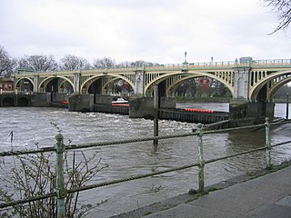
By the early 20th century the bridge was proving inadequate for the increasing traffic, particularly with the introduction of motorised transport, and a 10 miles per hour (16km/h) speed limit was enforced.[31] With the remaining investment income from tolls insufficient to pay for major reconstruction, on 31 March 1931 the bridge was taken into the joint public ownership of Surrey and Middlesex councils, and proposals were made to widen it.[32] The plans were strongly opposed on aesthetic grounds, and the decision was taken to build instead a new bridge a short distance downstream to relieve traffic pressure.[32]
The join between the narrow 1770s structure and the paler 1930s widening is clearly visible under the bridge arches
The new Twickenham Bridge opened in 1933, but Richmond Bridge was still unable to handle the volume of traffic, so in 1933 Sir Harley Dalrymple-Hay proposed possible methods for widening the bridge without significantly affecting its appearance.[32] The cheapest of Dalrymple-Hay's proposals, to transfer the footpaths onto stone corbels projecting from the sides of the bridge thus freeing the entire width for vehicle traffic, was rejected on aesthetic grounds, and a proposal to widen the bridge on both sides was rejected as impractical. A proposal to widen the bridge on the upstream side was settled on as causing the least disruption to nearby buildings,[32] and in 1934 it was decided to widen the bridge by 11 feet (3.4m), at a cost of £73,000 (about £5.51million in 2024).[13][32]
The Cleveland Bridge & Engineering Company of Darlington was appointed to carry out the rebuilding.[32] In 1937 each stone on the upstream side was removed and numbered and the bridge widened; the stone facing of the upstream side was then reassembled and the bridge reopened to traffic in 1940.[31] Throughout the redevelopment, a single lane of traffic was kept open at all times.[17] It was found that the 18th-century foundations, consisting of wooden platforms sunk into the river bed, had largely rotted away, and they were reinforced with steel pilings and concrete foundations.[17] During the widening works the opportunity was also taken to lower slightly the roadbed at the centre of the bridge and raise the access ramps, reducing the humpbacked nature of the bridge's central section.[33]
Legacy
Victorian gas lamp post on Richmond Bridge
James Paine went on to design three other Thames bridges after Richmond, at Chertsey (1783), Kew (1783), and Walton (1788). Paine and Couse renewed their working relationship on the design of Chertsey Bridge, the only one of the three still in existence.[14] Paine became High Sheriff of Surrey in 1783.[34]
In 1962, Richmond Council announced the replacement of the gaslamps on the bridge with electric lighting.[33] The Richmond Society, a local pressure group, protested at the change to the character of the bridge, and succeeded in forcing the council to retain the Victorian gas lamp-posts, converted to electric light, which remain in place today.[17]
In the history of Richmond Bridge there have only been two reported serious collisions between boats and the bridge. On 20 March 1964, three boats tied together at Eel Pie Island, 1+1⁄2 miles (2.4km) upstream, broke from their moorings in a storm and were swept downstream, colliding with the bridge. Although no serious damage was caused to the bridge, the Princess Beatrice, an 1896 steamer once used by Gilbert and Sullivan, was damaged beyond repair.[17] On 30 January 1987, the Brave Goose, the £3,500,000 yacht of National Car Parks founder Sir Donald Gosling, became wedged under the central arch of the bridge, eventually being freed at low tide the next day.[35]
The eighth Thames bridge to be built in what is now Greater London,[36] Richmond Bridge is currently the oldest surviving bridge over the Thames in Greater London,[n 3] and the oldest Thames bridge between the sea and Abingdon Bridge in Oxfordshire. Richmond Bridge was Grade I listed in 1952[37] and it is the only Georgian bridge over the Thames in London. Its bicentenary was celebrated on 7 May 1977; the commemoration was held four months after the actual anniversary of 12 January, to avoid poor weather conditions.[38]
The tradition of boat hire, repairs and boatbuilding continues at the bridge and tunnels at Richmond Bridge Boathouses under boatbuilder Mark Edwards,[39] awarded his MBE in 2013 for "services to boatbuilding"[40][41] including construction of the royal barge Gloriana.[42]
Just to the south of the bridge, in a park at the Richmond end, is a bust of the first president of Chile, Bernardo O'Higgins, who studied in Richmond from 1795 until 1798. In 1998, 200 years after he left Richmond, the bust, whose sculptor is unknown, was unveiled. The patch of ground which the statue overlooks is called "O'Higgins Square". The Mayor of Richmond lays a wreath at the bust every year in the presence of staff from the Chilean Embassy in London.[43]
↑ The tontine shares were transferable, although the payment of the dividend relied on the survival of the original investor.
↑ The smaller second tontine continued until the death of its last shareholder in 1865, paying a total of £200 per annum; for the last six years this was paid from the accumulated toll revenues of previous years.
Twickenham is a suburban district in London, England. It is situated on the River Thames 9.9 miles (15.9 km) southwest of Charing Cross. Historically part of Middlesex, it has formed part of the London Borough of Richmond upon Thames since 1965, and the borough council's administrative headquarters are located in the area.
Vauxhall Bridge is a Grade II* listed steel and granite deck arch bridge in central London. It crosses the River Thames in a southeast–northwest direction between Vauxhall on the south bank and Pimlico on the north bank. Opened in 1906, it replaced an earlier bridge, originally known as Regent Bridge but later renamed Vauxhall Bridge, built between 1809 and 1816 as part of a scheme for redeveloping the south bank of the Thames. The bridge was built at a location in the river previously served by a ferry.
Battersea Bridge is a five-span arch bridge with cast-iron girders and granite piers crossing the River Thames in London, England. It is situated on a sharp bend in the river, and links Battersea south of the river with Chelsea to the north. The bridge replaced a ferry service that had operated near the site since at least the middle of the 16th century.
Kew Bridge is a wide-span bridge over the Tideway linking the London Boroughs of Richmond upon Thames and Hounslow. The present bridge, which was opened in 1903 as King Edward VII Bridge by King Edward VII and Queen Alexandra, was designed by John Wolfe-Barry and Cuthbert A Brereton. Historic England listed it at Grade II in 1983.
Westminster Bridge is a road-and-foot-traffic bridge over the River Thames in London, linking Westminster on the west side and Lambeth on the east side.
Richmond Lock and Footbridge is a lock, rising and falling low-tide barrage integrating controlled sluices and pair of pedestrian bridges on the River Thames in southwest London, England, and is a Grade II* listed structure. It is the furthest downstream of the forty-five Thames locks and the only one owned and operated by the Port of London Authority. It was opened in 1894 and is north-west of the centre of Richmond in a semi-urban part of southwest London. Downstream are Syon Park and Kew Gardens on opposite banks. It connects the promenade at Richmond with the neighbouring district of St. Margarets on the west bank during the day and is closed at night to pedestrians – after 19:30 GMT or after 21:30 when BST is in use. At high tide the sluice gates are raised and partly hidden behind metal arches forming twin footbridges.
Teddington Lock is a complex of three locks and a weir on the River Thames between Ham and Teddington in the London Borough of Richmond upon Thames, England. Historically in Middlesex, it was first built in 1810.
Twickenham Bridge crosses the River Thames in southwest London, England. Built in 1933 as part of the newly constructed "Chertsey Arterial Road", the bridge connects the Old Deer Park district of Richmond on the south bank of the river to St. Margarets on the north bank, both within the London Borough of Richmond upon Thames. Twickenham Bridge gets its name from the fact that it is on the road to the town of Twickenham, which is approximately 3 km upstream from Twickenham Bridge, past Richmond Bridge. Given the bridge's unique position on the river, St Margarets is actually at the southwestern end of the bridge, despite being on the north bank, while Richmond, south of the Thames, is at the northeastern end of the bridge.
The Thames Path is a National Trail following the River Thames from one of its sources near Kemble in Gloucestershire to the Woolwich foot tunnel, south east London. It is about 185 miles (298 km) long. A path was first proposed in 1948 but it only opened in 1996.
Wandsworth Bridge crosses the River Thames in west London. It carries the A217 road between the area of Battersea, near Wandsworth Town Station, in the London Borough of Wandsworth on the south of the river, and the areas of Sands End and Parsons Green, in the London Borough of Hammersmith and Fulham, on the north side.
Kingston Bridge is a road bridge at Kingston upon Thames in south west London, England, carrying the A308 across the River Thames. It joins the town centre of Kingston in the Royal Borough of Kingston upon Thames to Hampton Court Park, Bushy Park, and the village of Hampton Wick in the London Borough of Richmond upon Thames. In 2005 it was carrying approximately 50,000 vehicles per day with up to 2,000 vehicles per hour in each direction during peak times.
Chiswick Bridge is a reinforced concrete deck arch bridge over the River Thames in West London. It is one of three bridges opened in 1933 as part of an ambitious scheme to relieve traffic congestion west of London. The structure carries the A316 road between Chiswick on the north bank of the Thames and Mortlake on the south bank.
Hampton Court Bridge is a Grade II listed bridge that crosses the River Thames in England approximately north–south between Hampton, London and East Molesey, Surrey, carrying the A309. It is the upper of two road bridges on the reach above Teddington Lock and downstream of Molesey Lock.
Chertsey Bridge is a road bridge across the River Thames in England, connecting Chertsey to low-lying riverside meadows in Laleham, Surrey. It is 550 yards (500 m) downstream from the M3 motorway bridge over the Thames and is close to Chertsey Lock on the reach above Shepperton Lock. The bridge is a seven-arch tied arch white stone bridge built 1783–85 and is a Grade II* listed building. It has a weight restriction of 18 tonnes for LGVs.
Three river islands (aits) form a linear group, close to the junction of the two main old streets of Thames Ditton village, in the River Thames in a corner of modern Surrey, on the Kingston reach above Teddington Lock. Thames Ditton Island, the dominant ait, is 350 yards (320 m) long and has 48 houses with gardens ; Boyle Farm Island has one house; Swan Island, between the two, is the smallest.
Staines Bridge is a road bridge running in a south-west to north-east direction across the River Thames in Surrey. It is on the modern A308 road and links the boroughs of Spelthorne and Runnymede at Staines-upon-Thames and Egham Hythe. The bridge is Grade II listed.
Walton Bridge is a road bridge across the River Thames in England, carrying the A244 between Walton-on-Thames and Shepperton, crossing the Thames on the reach between Sunbury Lock and Shepperton Lock.
Hammerton's Ferry is a pedestrian and cycle ferry service across the River Thames in the London Borough of Richmond upon Thames, London, England. The ferry links the river's northern bank near Marble Hill House in Twickenham with its southern bank near Ham House in Ham. It is one of only four remaining ferry routes in London not to be replaced by a bridge or tunnel.
Swan Island is a private mooring island in the Thames at Twickenham, in the London Borough of Richmond upon Thames, London, England. It is on the Tideway about 3⁄4 mile (1.2 km) north of and thus below Teddington Lock.
↑ Reynolds, Susan (1962), "Twickenham: Introduction", Victoria County History. A History of the County of Middlesex, 3: 139–147, retrieved 30 December 2007
↑ The London Magazine, September 1779, quoted in Cookson 2006, p.31
↑ Colvin, Howard, A Biographical Dictionary of British Architects 1600–1840, 3rd ed. (Yale University Press), 1995, s.v. "James Paine". The volume was reprinted by the Gregg Press in 1967
Milner, William (1839), The Wonders of Nature and Art: Comprising Nearly Three Hundred of the Most Remarkable Curiosities and Phenomena in the Known World, London: William Milner, OCLC9406884
This page is based on this Wikipedia article Text is available under the CC BY-SA 4.0 license; additional terms may apply. Images, videos and audio are available under their respective licenses.