Robinson Nature Center

Last updated
Robinson Nature Center
Robinson Nature center (distant).jpg
Robinson Nature center building (background), and wildflower gardens (foreground).
Robinson Nature Center
Type Nature center
Location6692 Cedar Lane
Columbia, Maryland 21044
Coordinates 39°11′26″N76°53′42″W / 39.190606°N 76.894898°W / 39.190606; -76.894898
Area22 acres (0.089 km2)
Created2009
Operated by Howard County, Maryland
Website www.howardcountymd.gov/RobinsonNatureCenter

The James and Anne Robinson Nature Center is a nature education facility situated on 18 acres of park land adjacent to the Middle Patuxent Environmental Area. Geothermal heating/air-conditioning, porous paving, solar panels, water conservation methods and other features make this building environmentally-friendly and have earned it the LEED Certified Platinum designation. Each year, the Center runs over 450 programs including field trips, public programs, birthday parties, home school and scout programs. [1] James and Anne Robinson cared for the property for decades and kept it from being used by developers, ultimately arranging transfer to Howard County, Maryland for enjoyment by the general public. The Center continues to be partially supported by the James & Anne Robinson Foundation and is owned and operated by the Howard County Department of Recreation & Parks.

Contents

Property history

The Nature Center was built on 18.3 of 22 acres [2] of a 31-acre parcel that had been split from the Simpsonville Mill property by William and Rebecca Simpson and sold to Sophia Stern in 1891; subsequent sales were to Isaac Goldstein and Louis Abram in 1894, Eli Goldstein and family (Russian immigrants) in 1897, David and Agnes Johnson in 1902, Charles and Alice Baldwin in 1911, John Clifford and Martha Wall in 1914 (then 23.75 acres), and Harry and Rachel Saumenig in 1921. [3] The property was purchased by James and Anne Robinson in 1957; it is adjacent to the modern Middle Patuxent Environmental Area and the core properties on Cedar Lane that were assembled to start the Rouse development of Columbia, Maryland. After decades of offers to buy the property for dense development, Anne Robinson approached the county in 2002 about passing the land to them for operation of a nature center. The purchase was settled on February 18, 2005, with funding from $1.7 million in county development excise taxes and $300,000 of Program Open Space money. The James & Anne Robinson Foundation, which Anne and her accountant created in 2003 to hold the property, returned $1 million of the proceeds of the sale as a contribution toward construction of the facility. Anne Robinson did not live to see the opening of the Nature Center; she died in 2005 at the age of 89. Her husband James had died in 1977. [4]

In 2009, capital project funding of $1,010,000 was transferred from Meadowbrook Park, $250,000 from Rockburn Branch Park, $600,000 from Western Regional Park, $300,000 from Patapsco Female Institute, $600,000 from Cedar Lane School, $320,000 from Cedar Lane Athletic Improvements and Park Headquarters to build Robinson Nature Center. A total of $962,000 was budgeted for onsite road construction. [5] [6]

The center had its groundbreaking in 2009, although one Robinson family member expressed the family's unhappiness about the project. [7] After the groundbreaking, the remains of the Robinson's mid-to-late 19th-century frame house adjacent to the Simpsonville Mill, [2] in which Anne had lived until 2004 and which had been demolished in February 2005, [4] were dismantled, as was a barn on the property. Wood from the barn was saved and, upon construction of the building, used to create siding and tables for an area in the front lobby dedicated to James & Anne Robinson as the "Legacy Room." The Nature Center, designed by GWWO Architects and built by Forrester Construction Co and KCI Technologies, opened on September 10, 2011. [8]

The stone stairs that once led to the front porch of the Robinson house still remain on the property in their original location. A covered pavilion was erected in 2014 on the site of the house with the footprint of the original house etched in stonework on the pavilion's floor. In what was the front yard of the house, Anne Robinson had maintained planted gardens. Plants from these gardens were preserved, and a memorial garden was created around the original landscaping with the addition of native shrubs and trees, benches and a stone pathway.

Anne Robinson's Letter of Instruction

In a notarized Letter of Instruction, dated September 25, 2002, Anne Robinson left guidance to Jeffrey D. Ring, her attorney-in-fact and Personal Representative under her Last Will and Testament. The letter stated: [9]

I have lived the majority of my life on property known as 6692 Cedar Lane, Columbia, Maryland 21044 (the "Property"). I have become part of the Property, and the Property has become part of me. The memories of my late husband, James Howard Robinson; the beauty of the woods; the sounds of creatures; and the wonders of nature; all are part of me and my Property. It is my wish and desire to maintain my Property in its natural state for all to enjoy as I have. To that end, I have made provisions in my Last Will and Testament related to the disposition of my Property. In the event I become disabled or otherwise legally incompetent, I want all to know my desires and wishes. I am not concerned with the economic value of my Property nor am I concerned about leaving it to potential heirs. I want the Property to serve as a source of inspiration, education and beauty for the general public.

Building

The 18-acre (7.3 ha) park features a 23,000 sq ft (2,100 m2) LEED Platinum certified nature center building, built at a cost of $17.6 million. Constructed of reinforced concrete, with wood and stone above grade, the three-story building contains a 120-seat auditorium, 50-seat planetarium, solar panels, geothermal heating and parking for 112 vehicles on a parking lot constructed of permeable paving. A goal of the architect was to show how animals and plants co-exist with people in developed regions. A goal of the exhibit designer was to have people use the building as a starting point to learn about nature and then head outdoors to tour the trails and other areas. [10]

Related Research Articles

<span class="mw-page-title-main">Columbia, Maryland</span> Planned community

Columbia is a census-designated place in Howard County, Maryland, United States. It is a planned community consisting of 10 self-contained villages. The census-designated place had a population of 104,681 at the 2020 census, making it the second most populous community in Maryland after Baltimore. Columbia, located between Baltimore and Washington, D.C., is officially part of the Baltimore metropolitan area.

<span class="mw-page-title-main">Patuxent River</span> River in Maryland, United States

The Patuxent River is a tributary of the Chesapeake Bay in the state of Maryland. There are three main river drainages for central Maryland: the Potomac River to the west passing through Washington, D.C., the Patapsco River to the northeast passing through Baltimore, and the Patuxent River between the two. The 908-square-mile (2,352 km2) Patuxent watershed had a rapidly growing population of 590,769 in 2000. It is the largest and longest river entirely within Maryland, and its watershed is the largest completely within the state.

<span class="mw-page-title-main">Guilford, Maryland</span> Unincorporated community in Maryland, United States

Guilford is an unincorporated community located in Howard County in the state of Maryland. The location is named after the Guilford Mill. Guilford is near Kings Contrivance, one of the nine "villages" of Columbia.

<span class="mw-page-title-main">River Hill, Columbia, Maryland</span> Village in Maryland, United States

River Hill is the last and westernmost village to be developed in the town of Columbia, Maryland, United States, though some residents maintain addresses in Clarksville. The village is home to 6,520 residents in 2,096 housing units in 2014. The area was used as a game preserve by James Rouse to entertain clients and personal hunting during the buildout of the Columbia project. In 1976, County Executive Edward L. Cochran selected the 784-acre parcel owned by Howard Research and Development for an alternate location for a county landfill; a task force selected Alpha Ridge Landfill instead. Residential construction started in 1990. It is bounded by Maryland Route 108 and Maryland Route 32, and is centered on Trotter Road. The village is divided into two neighborhoods: Pheasant Ridge and Pointers Run, with about 6,500 residents.

<span class="mw-page-title-main">Kings Contrivance, Columbia, Maryland</span> Village in Maryland, United States

Kings Contrivance is a village in the planned community of Columbia, Maryland, United States and is home to approximately 11,000 residents. It is Columbia's southernmost village, and was the eighth of Columbia's ten villages to be developed. Kings Contrivance consists of the neighborhoods of Macgill's Common, Huntington and Dickinson, and includes single-family homes, townhouses, apartments and a Village Center.

<span class="mw-page-title-main">Hickory Ridge, Columbia, Maryland</span> Village in Maryland, United States

Hickory Ridge is one of the 10 villages in Columbia, Maryland, United States, located to the west of the Town Center with a 2014 population of 13,000 in 4,659 housing units. The village overlays the former postal community of Elioak. It was first occupied in 1974. Neighborhoods in the village are Hawthorn, Clary's Forest, and Clemens Crossing. The name Hickory Ridge is derived from the 1749 estate "Hickory Ridge" in nearby Highland, which later became the family home of the nephew of hospital and university founder Johns Hopkins.

<span class="mw-page-title-main">Maryland Route 175</span> State highway in Howard and Anne Arundel Counties, Maryland, U.S.

Maryland Route 175 is a state highway in the U.S. state of Maryland. The highway runs 17.01 miles (27.37 km) from Little Patuxent Parkway in Columbia east to MD 3 in Millersville. MD 175 is a major highway through the large unincorporated community of Columbia; the highway connects U.S. Route 29 next to Columbia Town Center with Interstate 95 (I-95) and an industrial area on the eastern side of Howard County. MD 175 also connects Fort Meade with Jessup and Odenton in western Anne Arundel County, where it links MD 295 and MD 32 with the eastern part of the U.S. Army base.

<span class="mw-page-title-main">Blandair</span>

Blandair, also known as Blandair Farm, Blandair Park, and Blandair Regional Park, is 300 acres of former slave plantation located in Columbia, Maryland. The Blandair Foundation estate of Mrs. Smith was purchased by Howard County, Maryland in the late 1990s and is in the process of being developed as a regional park.

<span class="mw-page-title-main">Maryland Route 32</span> State highway in Maryland, US

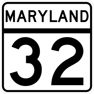
Maryland Route 32 (MD 32) is a state highway in the U.S. state of Maryland. The road runs 51.79 miles (83.35 km) from Interstate 97 (I-97) and MD 3 in Millersville west and north to Washington Road in Westminster. The 30 mile four- to six-lane freeway portion of MD 32 is the Patuxent Freeway between I-97 and I-70 in West Friendship. The freeway passes through Odenton and Fort Meade, the site of Fort George G. Meade and the National Security Agency (NSA), in western Anne Arundel County and along the southern part of Columbia in Howard County. Via I-97, MD 32 connects those communities with U.S. Route 50 (US 50)/US 301 in Annapolis. MD 32 also intersects the four primary highways connecting Baltimore and Washington: the Baltimore–Washington Parkway, US 1, I-95, and US 29. MD 32's north–south section, Sykesville Road, connects West Friendship and Westminster by way of Sykesville and Eldersburg in southern Carroll County.

<span class="mw-page-title-main">Dorsey's Search, Columbia, Maryland</span> Village in Maryland, United States

Dorsey's Search is a parcel of land patented by John Dorsey of Hockley-in-the-hole (1645–1714) in Baltimore County. The 479-acre (194 ha) property adjacent to the north branch of the Patuxent river was surveyed by Richard Beard in December 1684, and granted to Dorsey in March 1696. The property lying between "Long Reach" and "Elk Ridge" was resurveyed in March 1723 to include 750 acres (300 ha). After several generations of inheritance, a series of legal disputes were held over the land by Rezin Hammond and Richard Ridgley in 1820. In 1827 the property exchanged hands to Robert Oliver, builder of Oakland Mill, who combined it with multiple properties totaling 2,300 acres (930 ha). George Gaither acquired the property in 1838. John Dorsey's grandson, "Patuxent" John Dorsey of "Dorsey's Search" built Dorsey Hall at the site.

<span class="mw-page-title-main">Town Center, Columbia, Maryland</span> Village in Maryland, United States

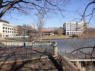
Town Center is one of the ten villages in Columbia, Maryland, United States, first occupied in 1974. The Town Center is a non-contiguous, diverse area, and the most urban-like, ranging from multi-level high density apartments, homes and office buildings to single family homes.

Simpsonville is an unincorporated community in Howard County, Maryland, United States.

<span class="mw-page-title-main">Whiskey Bottom Road</span> Historic road north of Laurel, Maryland, U.S.

Whiskey Bottom Road is a historic road north of Laurel, Maryland that traverses Anne Arundel and Howard Counties in an area that was first settled by English colonists in the mid-1600s. The road was named in the 1880s in association with one of its residents delivering whiskey after a prohibition vote. With increased residential development after World War II, it was designated a collector road in the 1960s; a community center and park are among the most recent roadside developments.

<span class="mw-page-title-main">Howard County Conservancy</span> Land trust and nature center in Maryland, United States

The Howard County Conservancy is a non-profit land trust that operates a nature center in Woodstock, Maryland. It is located at the 300-year-old, 232-acre (0.94 km2) Mt. Pleasant Farm.

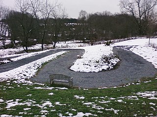
The Middle Patuxent Environmental Area (MPEA) is a 1,021-acre (4.13 km2) wildlife area in Clarksville, Maryland and operated by the Howard County Department of Recreation and Parks. It is located next to the River Hill village in the town of Columbia, Maryland, in the United States. The MPEA was created in 1996 for educational, research, and recreational purposes.

<span class="mw-page-title-main">Belmont Estate</span> Historic estate located at Elkridge, Howard County, Maryland, United States

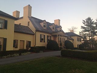
The Belmont Estate, now Belmont Manor and Historic Park, is a former plantation located at Elkridge, Howard County, Maryland, United States. Founded in the 1730s and known in the Colonial period as "Moore's Morning Choice", it was one of the earliest forced-labor farms in Howard County, Maryland. Its 1738 plantation house is one of the finest examples of Colonial Georgian architectural style in Maryland.

Atholton is an unincorporated community in Howard County, Maryland, United States. A postal office operated from May 26, 1897, to November 1900 and again from 1903 to July 1917.

<span class="mw-page-title-main">Simpsonville Mill</span> Grist Mill in Columbia, Maryland

The Simpsonville Mill is a historic pre-colonial mill complex in Simpsonville, Maryland, part of the Columbia, Maryland land development.

<span class="mw-page-title-main">Athol Manor</span> Historic slave manor and rectory in Columbia, Maryland, US

Athol is a historic slave manor and rectory located in Columbia (Simpsonville), Howard County, Maryland, U.S.

<span class="mw-page-title-main">Hatfield Safe House</span> Historic site in Columbia, Maryland

Hatfield Safe House, or Simpsonville Mill Miller's House is a historic home located at Columbia, Howard County, Maryland, United States.

References

  1. "Robinson Nature Center | The Best Things to do with Kids - ZuzuForKids". zuzuforkids.com. Retrieved 2024-01-23.
  2. 1 2 Suffness, Rita (March 12, 1993). "HO-636 Robinson House" (PDF) (PDF). Maryland Historical Trust. pp. 2–3. Retrieved June 9, 2014.
  3. John Milner Associates (1994). "Simpsonville Data Recovery Investigations" (PDF). Archived from the original (PDF) on November 7, 2017. Retrieved June 16, 2014.
  4. 1 2 Larry Carson (March 4, 2005). "Landowner's last wish fulfilled Preserve: A highly valued property is acquired by Howard County for a nature center". The Baltimore Sun. Archived from the original on December 15, 2017. Retrieved December 30, 2013.
  5. Howard County Department of Public Works (October 7, 2009). Testimony for Transfer of Appropriation Ordinance Meadowbrook Park (Capital Project N-3105).
  6. Howard County Department of Public Works (January 28, 2009). Testimony and Fiscal Note Testimony Appropriation Ordinance 2-2009.
  7. Larry Carson (August 30, 2009). "Family That Gave Land For Nature Center Isn't Happy". The Baltimore Sun. Archived from the original on December 16, 2017. Retrieved December 30, 2013.
  8. Andrew Metcalf (September 21, 2012). "Robinson Nature Center Celebrates 1st Anniversary". Columbia Patch. Patch Media . Retrieved December 30, 2013.
  9. Robinson, A. S. (2002, September 25). Letter of Instruction [Letter]. Howard County, Maryland.
  10. Gunts, Edward (September 15, 2011). "Columbia's nature center is a front door to suburban landscape". The Baltimore Sun. Archived from the original on December 16, 2017. Retrieved December 15, 2017.