Rockwood, Tennessee

Last updated

Rockwood, Tennessee
Rockwood-Street-tn3.jpg
Rockwood Street
Roane County Tennessee Incorporated and Unincorporated areas Rockwood Highlighted 4764440.svg
Location of Rockwood in Roane County, Tennessee.
Coordinates: 35°52′9″N84°40′31″W / 35.86917°N 84.67528°W / 35.86917; -84.67528
CountryUnited States
State Tennessee
County Roane
Founded1868
Incorporated1890 [1]
Named for William O. Rockwood
Government
  MayorJason Jolly
Area
[2]
  Total8.04 sq mi (20.83 km2)
  Land8.02 sq mi (20.76 km2)
  Water0.03 sq mi (0.08 km2)
Elevation
[3]
892 ft (272 m)
Population
 (2020) [4]
  Total5,444
  Density679.23/sq mi (262.25/km2)
Time zone UTC-5 (Eastern (EST))
  Summer (DST) UTC-4 (EDT)
ZIP code
37854
Area code 865
FIPS code 47-64440 [5]
GNIS feature ID1299838 [3]
Website City website

Rockwood is a city in Roane County, Tennessee, United States. Its population was 5,562 at the time of the 2010 census. It is included in the Harriman, Tennessee Micropolitan Statistical Area.

Contents

Geography

Rockwood is located at 35°52′9″N84°40′31″W / 35.86917°N 84.67528°W / 35.86917; -84.67528 (35.869147, -84.675176). [6] The city is situated at the base of the eastern escarpment of the Cumberland Plateau, known locally as Walden Ridge. The boundary between the Eastern Time Zone and Central Time Zone runs along Rockwood's western boundary. The Watts Bar Lake impoundment of the Tennessee River provides much of Rockwood's southern boundary.

Rockwood, viewed from Mt. Roosevelt (Walden Ridge) Rockwood-tennessee-overview.jpg
Rockwood, viewed from Mt. Roosevelt (Walden Ridge)

Rockwood is situated around a series of roads which intersect U.S. Route 70 between its junction with State Route 29 in the northeast and State Route 27 to the southwest. In recent years, the town has expanded toward Interstate 40 to the northeast. Rockwood is a familiar site to travelers who frequent I-40 between Knoxville and Nashville, as dramatic views of Rockwood and the Tennessee Valley beyond line the interstate just before it peaks at the edge of the Cumberland Plateau.

According to the United States Census Bureau, the city has a total area of 7.9 square miles (20 km2), of which 7.9 square miles (20 km2) is land and 0.1 square miles (0.26 km2) (0.63%) is water.

Climate

Climate data for Rockwood, Tennessee (1991–2020 normals, extremes 1962–2012)
MonthJanFebMarAprMayJunJulAugSepOctNovDecYear
Record high °F (°C)74
(23)
78
(26)
86
(30)
91
(33)
93
(34)
100
(38)
107
(42)
102
(39)
98
(37)
89
(32)
81
(27)
77
(25)
107
(42)
Mean maximum °F (°C)64.9
(18.3)
69.3
(20.7)
78.2
(25.7)
85.0
(29.4)
87.1
(30.6)
92.0
(33.3)
95.0
(35.0)
93.4
(34.1)
90.5
(32.5)
82.1
(27.8)
75.0
(23.9)
65.6
(18.7)
95.7
(35.4)
Mean daily maximum °F (°C)46.7
(8.2)
51.2
(10.7)
60.6
(15.9)
70.3
(21.3)
77.7
(25.4)
84.5
(29.2)
87.5
(30.8)
86.5
(30.3)
81.8
(27.7)
70.7
(21.5)
58.9
(14.9)
49.8
(9.9)
68.8
(20.4)
Daily mean °F (°C)37.2
(2.9)
40.4
(4.7)
48.5
(9.2)
56.9
(13.8)
65.4
(18.6)
73.3
(22.9)
76.8
(24.9)
75.7
(24.3)
70.1
(21.2)
58.4
(14.7)
47.1
(8.4)
40.1
(4.5)
57.5
(14.2)
Mean daily minimum °F (°C)27.7
(−2.4)
29.6
(−1.3)
36.3
(2.4)
43.5
(6.4)
53.1
(11.7)
62.1
(16.7)
66.2
(19.0)
64.9
(18.3)
58.4
(14.7)
46.1
(7.8)
35.3
(1.8)
30.4
(−0.9)
46.1
(7.8)
Mean minimum °F (°C)8.2
(−13.2)
13.0
(−10.6)
20.9
(−6.2)
28.9
(−1.7)
38.8
(3.8)
50.9
(10.5)
57.2
(14.0)
56.4
(13.6)
43.5
(6.4)
30.8
(−0.7)
22.1
(−5.5)
13.8
(−10.1)
4.6
(−15.2)
Record low °F (°C)−12
(−24)
−10
(−23)
1
(−17)
21
(−6)
28
(−2)
36
(2)
46
(8)
44
(7)
28
(−2)
21
(−6)
8
(−13)
−8
(−22)
−12
(−24)
Average precipitation inches (mm)5.41
(137)
5.43
(138)
5.46
(139)
5.63
(143)
4.73
(120)
5.46
(139)
5.96
(151)
3.82
(97)
4.45
(113)
3.48
(88)
4.62
(117)
6.01
(153)
60.46
(1,536)
Average snowfall inches (cm)0.7
(1.8)
1.2
(3.0)
0.0
(0.0)
0.0
(0.0)
0.0
(0.0)
0.0
(0.0)
0.0
(0.0)
0.0
(0.0)
0.0
(0.0)
0.0
(0.0)
0.0
(0.0)
0.1
(0.25)
2.0
(5.1)
Average precipitation days (≥ 0.01 in)9.99.410.59.610.311.311.38.97.56.57.710.1113.0
Average snowy days (≥ 0.1 in)0.40.50.10.00.00.00.00.00.00.00.00.21.2
Source: NOAA (mean maxima/minima 19812010) [7] [8]

Demographics

Historical population
CensusPop.Note
1880 1,011
1890 2,305128.0%
1900 2,89925.8%
1910 3,66026.3%
1920 4,65227.1%
1930 3,808−18.1%
1940 3,9814.5%
1950 4,2727.3%
1960 5,34525.1%
1970 5,259−1.6%
1980 5,6878.1%
1990 5,348−6.0%
2000 5,7748.0%
2010 5,562−3.7%
2020 5,444−2.1%
Sources: [9] [10] [4]

2020 census

Rockwood racial composition [11]
RaceNumberPercentage
White (non-Hispanic)4,71086.52%
Black or African American (non-Hispanic)2274.17%
Native American 220.4%
Asian 370.68%
Pacific Islander 10.02%
Other/Mixed 3155.79%
Hispanic or Latino 1322.42%

As of the 2020 United States census, there were 5,444 people, 2,129 households, and 1,175 families residing in the city.

2000 census

As of the census [5] of 2000, there were 5,774 people, 2,478 households, and 1,558 families residing in the city. The population density was 731.4 inhabitants per square mile (282.4/km2). There were 2,729 housing units at an average density of 345.7 per square mile (133.5/km2). The racial makeup of the city was 92.86% White, 5.44% African American, 0.26% Native American, 0.29% Asian, 0.21% from other races, and 0.94% from two or more races. Hispanic/Latino/Tejano of any race were 0.81% of the population.

There were 2,478 households, out of which 25.2% had children under the age of 18 living with them, 44.8% were married couples living together, 14.7% had a female households with no husband present, and 37.1% were non-families. 34.0% of all households were made up of individuals, and 16.9% had someone living alone who was 65 years of age or older. The average household size was 2.25 and the average family size was 2.87.

In the city, the population was spread out, with 21.5% under the age of 18, 7.8% from 18 to 24, 25.0% from 25 to 44, 25.0% from 45 to 64, and 20.7% who were 65 years of age or older. The median age was 42 years. For every 100 females, there were 83.8 males. For every 100 females age 18 and over, there were 78.1 males.

The median income for a household in the city was $23,986, and the median income for a family was $32,237. Males had a median income of $27,188 versus $20,755 for females. The per capita income for the city was $13,106. About 17.4% of families and 21.9% of the population were below the poverty line, including 30.4% of those under age 18 and 17.6% of those age 65 or over.

History

Early history

A Cherokee village situated in what is now Rockwood was the headquarters of Chief Tallentuskie, a Cherokee leader in the late 18th and early 19th centuries. [12]

Roane Iron Company

The Roane Iron Company furnace site at the end of Rockwood Street; the small building on the left is all that remains of the once vast iron works Roane-iron-works-site-tn1.jpg
The Roane Iron Company furnace site at the end of Rockwood Street; the small building on the left is all that remains of the once vast iron works

Union general John T. Wilder, who in the 1850s had managed a foundry in Indiana, noted the iron ore and coal deposits of the Cumberland Plateau region while operating in the area during the Civil War. After the war, Wilder and Ohio-born Knoxville Iron Company founder Hiram Chamberlain (18351916) purchased 900 acres (360 ha) at what is now Rockwood, selecting the location due to the ore and coal resources at the base of Walden Ridge, the proximity to the Tennessee River, and an assumption that the encroaching railroads would descend the Plateau at nearby Emory Gap. Wilder and Chamberlain enlisted several other investors from Indiana and Ohio, and the Roane Iron Company was chartered on June 18, 1867. [1] By late 1868, the company had constructed a blast furnace with a capacity of 15 tons per day between the ridge and the end of what is now Rockwood Street. [13]

The company mined coal and iron ore along the ridge, which it transported by narrow-gauge rail to the furnace site. The coal was delivered to coking ovens, where it was converted into coke, and the coke was then used to generate the temperatures needed to convert the iron ore into pig iron. The pig iron was then shipped by river to rolling mills in Knoxville and Chattanooga, and was used primarily in railroad construction. In the early 1880s, Roane Iron purchased a rolling mill in Chattanooga and experimented with steel production, but the Walden Ridge ore proved to be too low-quality for such a process, and the company abandoned its steel venture in 1889. [14]

Roane Iron's Rockwood furnace employed a mix of local labor (both caucasian and African-American) and immigrants (especially Welsh immigrants), and did not practice wage discrimination. [1] The company paid workers either cash, which was issued on paydays, or scrip, which could be issued anytime at the worker's request. Other than a miners' strike in 1904, Roane Iron experienced relatively few labor disputes, even though labor organizations were active in Rockwood. A series of mining accidents namely a 1926 mine explosion damaged the company's image and led to out-of-control workers' compensation payments, however, and in 1929 Roane Iron shut down operations. [1]

Development of Rockwood

Worried that the region's Confederate-sympathizers might shun an operation led by a well-known Union general, Wilder decided to name Roane Iron's company town after one of its lesser-known Indiana investors, William O. Rockwood. In spite of the name, William Rockwood played only a minor role in Roane Iron's affairs, and the early development of the town was largely the work of Wilder and Chamberlain. Unlike the "boom" towns in nearby Cardiff and Harriman, Rockwood's growth was gradual. Rockwood's population grew from 696 in 1870 to 1,011 in 1880. By 1890, the city's population had swelled to 2,305. [1]

A parade in Rockwood in 1940 Rockwood-parade-1940-tn1.gif
A parade in Rockwood in 1940

For the first 50 years of its existence, Rockwood was polarized by the temperance issue. Wilder, a prohibitionist, banned alcoholic beverages on company property, and tried in vain to prevent drunkenness in the town throughout the 1870s. Saloons became commonplace in Rockwood in the 1880s, however, and Roane Iron began to struggle with absenteeism, as many employees worked for just a few days per week in order to make enough money for a "weekend of drinking and fighting." [1] In 1887, after the state's "four-mile" law effectively banned saloons in unincorporated areas, a section of the town incorporated as "East Rockwood" to dodge the law. Rockwood, which incorporated in 1890, passed an ordinance banning the sale of alcohol in 1903, but the ordinance didn't apply to railroads, and the so-called "jug train" from Chattanooga continued supplying Rockwood with liquor until the statewide prohibition law took effect in 1909. [1]

Noting the success of land auctions in nearby Cardiff and Harriman, Roane Iron held its own land auction for Rockwood in May 1890, selling several hundred lots and raising $600,000. To promote the city, the company laid out new streets, built new hotels, and allowed general stores to set up shop in the city and compete with the company store. [1] These de-paternalization measures helped Rockwood survive the Panic of 1893, which doomed neighboring Cardiff. [1]

20th century

In the early 20th century, Rockwood's economy further diversified. Former Roane Iron employee James Tarwater founded Rockwood Mills, which manufactured hosiery, in 1905. Another former Roane Iron employee, Sewell Howard, established Rockwood Stove Works in 1916.

On October 4, 1926, twenty-eight people were killed in a mine explosion in the area. [15]

After Roane Iron's collapse in 1929, Rockwood struggled with unemployment. At the outbreak of World War II, however, the Tennessee Products Corporation reopened the iron works to produce ferromanganese for the wartime effort. [1] Like other Roane County communities, Rockwood's economy was boosted by the government's construction of nearby Oak Ridge during World War II.

Notable people

Related Research Articles

<span class="mw-page-title-main">Roane County, Tennessee</span> County in Tennessee, United States

Roane County is a county of the U.S. state of Tennessee. As of the 2020 census, the population was 53,404. Its county seat is Kingston. Roane County is included in the Knoxville, TN Metropolitan Statistical Area.

<span class="mw-page-title-main">Morgan County, Tennessee</span> County in Tennessee, United States

Morgan County is a county located in the U.S. state of Tennessee. As of the 2020 census, the population was 21,035. Its county seat is Wartburg. Morgan County is part of the Knoxville, TN Combined Statistical Area.

<span class="mw-page-title-main">Loudon County, Tennessee</span> County in Tennessee, United States

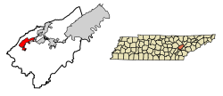
Loudon County is a county in the U.S. state of Tennessee. It is located in the central part of East Tennessee. As of the 2020 census, the population was 54,886. Its county seat is Loudon. Loudon County is included in the Knoxville, TN Metropolitan Statistical Area.

<span class="mw-page-title-main">Knox County, Tennessee</span> County in Tennessee, United States

Knox County is located in the U.S. state of Tennessee. As of the 2020 census, the population was 478,971, making it the third-most populous county in Tennessee. Its county seat is Knoxville, which is the third-most populous city in Tennessee. Knox County is included in the Knoxville metropolitan area. The county is located at the geographical center of the Great Valley of East Tennessee. Near the heart of the county is the origin of the Tennessee River, at the confluence of the Holston and French Broad rivers.

<span class="mw-page-title-main">Anderson County, Tennessee</span> County in Tennessee, United States

Anderson County is a county in the U.S. state of Tennessee. It is located in the northern part of the state in East Tennessee. As of the 2020 census, its population was 77,123. Its county seat is Clinton. Anderson County is included in the Knoxville, TN Metropolitan Statistical Area.

<span class="mw-page-title-main">Clinton, Tennessee</span> City in Tennessee, United States

Clinton is a city in and the county seat of Anderson County, Tennessee. Clinton is included in the Knoxville metropolitan area. Its population was 10,056 at the 2020 census.

<span class="mw-page-title-main">Pikeville, Tennessee</span> City in Tennessee, United States

Pikeville is a city in Bledsoe County, Tennessee. The population was 1,824 at the 2020 census. It is also the county seat of Bledsoe County.

<span class="mw-page-title-main">LaFollette, Tennessee</span> City in Tennessee, United States

LaFollette is a city in Campbell County, Tennessee, United States. Its population was 7,456 at the 2010 census, with an estimated population in 2018 of 6,737. It is the principal city of the LaFollette, Tennessee micropolitan statistical area, which includes all of Campbell County, and is a component of the Knoxville Metropolitan Area. While the city's official spelling is one word ("LaFollette")—after its founders, Harvey Marion LaFollette and his younger brother Grant LaFollette—several federal agencies spell the city's name with two words.

<span class="mw-page-title-main">Crossville, Tennessee</span> City in Tennessee, United States

Crossville is a city in and the county seat of Cumberland County, Tennessee, United States. It is part of the Crossville Micropolitan Statistical Area. The population was 12,071 at the 2020 census.

<span class="mw-page-title-main">Greenback, Tennessee</span> City in Tennessee, United States

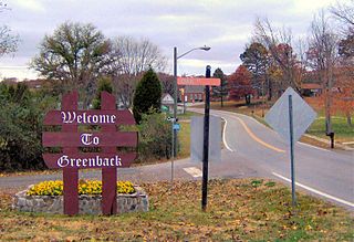
Greenback is a city in Loudon County, Tennessee, United States. Its population was at 1,102, according to the 2020 census. It is included in the Knoxville Metropolitan Statistical Area.

<span class="mw-page-title-main">Lenoir City, Tennessee</span> City in Tennessee, United States

Lenoir City is a suburban city located in Loudon County, Tennessee. The population was 10,117 at the 2020 census. It is included in the Knoxville metropolitan area in East Tennessee, along the Tennessee River southwest of Knoxville.

<span class="mw-page-title-main">South Pittsburg, Tennessee</span> City in Tennessee, United States

South Pittsburg is a city in Marion County, Tennessee, United States. It is part of the Chattanooga, TN–GA Metropolitan Statistical Area. The population was 3,106 at the 2020 census. South Pittsburg is home to the National Cornbread Festival.

<span class="mw-page-title-main">Sunbright, Tennessee</span> City in Tennessee, United States

Sunbright is a city in Morgan County, Tennessee, United States. The population was 519 at the 2020 census.

<span class="mw-page-title-main">Ducktown, Tennessee</span> City in Tennessee, United States

Ducktown is a city in Polk County, Tennessee, United States. The population was 461 at the 2020 census and 475 at the 2010 census. It is included in the Cleveland Metropolitan Statistical Area.

<span class="mw-page-title-main">Kingston, Tennessee</span> City in Tennessee, United States

Kingston is a city in and the county seat of Roane County, Tennessee, United States. This city is thirty-six miles southwest of Knoxville. It had a population of 5,934 at the 2010 United States census, and is included in the Harriman, Tennessee Micropolitan Statistical Area. Kingston is adjacent to Watts Bar Lake.

<span class="mw-page-title-main">Oliver Springs, Tennessee</span> Town in Tennessee, United States

Oliver Springs is a town in Anderson, Morgan, and Roane counties in the U.S. state of Tennessee. Its population was 3,231 at the 2010 census. It is included in the Harriman, Tennessee Micropolitan Statistical Area, which consists of Roane County.

<span class="mw-page-title-main">Harriman, Tennessee</span> City in Tennessee, United States

Harriman is a city located primarily in Roane County, Tennessee, with a small extension into Morgan County. The population of Harriman was 5,892 at the time of the 2020 census.

The Tennessee Central Railway was founded in 1884 as the Nashville and Knoxville Railroad by Alexander S. Crawford. It was an attempt to open up a rail route from the coal and minerals of East Tennessee to the markets of the midstate, a service which many businessmen felt was not being adequately provided by the existing railroad companies. They also wanted to ship coal and iron ore to the Northeastern US over the Cincinnati Southern Railway, which was leased to the Southern and operated as the Cincinnati, New Orleans and Texas Pacific Railway (CNOTP), through their Cincinnati gateway. The N&K was only completed between Lebanon, where it connected to a Nashville, Chattanooga and St. Louis Railway branch from Nashville, and Standing Stone.

<span class="mw-page-title-main">Knoxville metropolitan area</span> Metropolitan area in Tennessee, United States

The Knoxville metropolitan area, commonly known as Greater Knoxville, is a metropolitan statistical area (MSA) centered on Knoxville, Tennessee, the third largest city in Tennessee and the largest city in East Tennessee. It is the third largest metropolitan area in Tennessee. In 2020, the Knoxville metro area had a population of 879,773, and a population of 903,300 including Grainger County. The Knoxville–Morristown–Sevierville Combined Statistical Area (CSA) had a population of 1,156,861 according to the census bureau in 2020.

<span class="mw-page-title-main">Cardiff, Tennessee</span> Company town in Tennessee, United States

Cardiff was a company town located in Roane County, Tennessee, United States. Established in the early 1890s by New England investors, the town was to house workers and managers for a large-scale mining operation that sought to utilize the abundant iron ore and coal resources along nearby Walden Ridge. The town was named for Cardiff, Wales, as its planners believed it would someday rival the Welsh city as a mining mecca. The town's development was thwarted, however, when the Panic of 1893 left its parent company in financial ruin. Little remains of the town today.

References

  1. 1 2 3 4 5 6 7 8 9 10 William Moore, "Preoccupied Paternalism: The Roane Iron Company In Her Company Town Rockwood, Tennessee." East Tennessee Historical Society Publications Vol. 39 (1967), pp. 56-70.
  2. "ArcGIS REST Services Directory". United States Census Bureau. Retrieved October 15, 2022.
  3. 1 2 U.S. Geological Survey Geographic Names Information System: Rockwood, Tennessee
  4. 1 2 "Census Population API". United States Census Bureau. Retrieved October 15, 2022.
  5. 1 2 "U.S. Census website". United States Census Bureau . Retrieved January 31, 2008.
  6. "US Gazetteer files: 2010, 2000, and 1990". United States Census Bureau. February 12, 2011. Retrieved April 23, 2011.
  7. "NowData - NOAA Online Weather Data". National Oceanic and Atmospheric Administration. Retrieved October 8, 2021.
  8. "Station: Rockwood 2, TN". U.S. Climate Normals 2020: U.S. Monthly Climate Normals (1991-2020). National Oceanic and Atmospheric Administration. Retrieved October 8, 2021.
  9. "Census of Population and Housing: Decennial Censuses". United States Census Bureau . Retrieved March 4, 2012.
  10. "Incorporated Places and Minor Civil Divisions Datasets: Subcounty Resident Population Estimates: April 1, 2010 to July 1, 2012". Population Estimates. U.S. Census Bureau. Archived from the original on June 11, 2013. Retrieved December 11, 2013.
  11. "Explore Census Data". data.census.gov. Retrieved December 27, 2021.
  12. Stanley Wassom, "Rockwood A Historic Perspective". The City of Rockwood official website, 2006. Retrieved: December 29, 2007.
  13. John Benhart, Appalachian Aspirations: The Geography of Urbanization and Development in the Upper Tennessee River Valley, 1865-1900 (Knoxville, Tenn.: University of Tennessee Press, 2007), pp. 5-7.
  14. Benhart, pp. 34-41.
  15. ""Disasters"". Powell Valley News. January 7, 1927. Retrieved August 21, 2023.
  16. Boyd, Tyler L. (2019). Tennessee Statesman Harry T. Burn: Woman Suffrage, Free Elections, and a Life of Service. Charleston, South Carolina: The History Press. ISBN   978-1-4671-4318-9. Retrieved May 28, 2019.