Romeo, Michigan

Last updated

Romeo, Michigan
RomeoMichiganB.JPG
Downtown at 32 Mile Road and Main Street
Nickname(s): 
Uptown, The Four Corners
Romeo (village), MI location.png
Location within Macomb County
USA Michigan location map.svg
Red pog.svg
Romeo
Usa edcp location map.svg
Red pog.svg
Romeo
Coordinates: 42°48′10″N83°00′47″W / 42.80278°N 83.01306°W / 42.80278; -83.01306
Country United States
State Michigan
County Macomb
Townships Bruce; Washington
Area
[1]
  Total2.05 sq mi (5.32 km2)
  Land2.05 sq mi (5.31 km2)
  Water0.00 sq mi (0.01 km2)
Elevation
[2]
810 ft (250 m)
Population
 (2020) [3]
  Total3,767
  Density1,835.77/sq mi (708.89/km2)
Time zone UTC-5 (Eastern (EST))
  Summer (DST) UTC-4 (EDT)
ZIP Code
48065
Area code 586
FIPS code 26-69400 [4]
GNIS feature ID0636145 [2]
Website www.villageofromeo.org

Romeo is a village in Macomb County in the U.S. state of Michigan. The population was 3,767 at the 2020 census. [3] Romeo is located on the rural-urban fringe of the Detroit metropolitan area, and many of its residents commute to jobs closer to the city.

Contents

History

A settlement here was originally occupied by the indigenous Chippewa (Ojibwe), an Algonquian-speaking people who were part of a large language family of tribes extending to the Atlantic Coast. Those tribes around the Great Lakes are thought to have migrated to this area by the 12th century.

The early European-American settlers in this area referred to the Chippewa settlement as "Indian Village". In the 1820s and 1830s more migrant European-American families began to settle in the area, building homes and establishing businesses. They renamed the community "Hoxie's Settlement", after a man who opened an inn on Main Street. In 1839, Hoxie's Settlement became incorporated and was renamed as the village of Romeo. [5] The name was suggested by the wife of local merchant Nathaniel Taylor because it was "short, musical, classical and uncommon." [6] Romeo celebrated its 175th anniversary on March 9, 2013.

Panoramic map of Romeo with list of landmarks, 1868 Bird's eye view of Romeo 1868. LOC 73693444.jpg
Panoramic map of Romeo with list of landmarks, 1868

Romeo once served as a trading center for the timber industry, and had many mills processing lumber from the region. Many wealthy timber families resided there. Dozens of stately Victorian mansions survive. Romeo is distinct in the area for having a fairly robust, traditional downtown, which has never suffered a major fire. Because of this, some stores and restaurants downtown have features such as original tin ceilings from the Civil War. In the early 20th century, Romeo was the site of an early business devoted to the new automobile industry: the Detroit Auto Vehicle Company operated here from 1904 until 1908.

Geography

The village is in northwestern Macomb County, situated at the southeast corner of Bruce Township, with a portion extending south into Washington Township. Armada Township is adjacent to the east and Ray Township to the southeast. Highway M-53 passes through the east side of the village, leading north 16 miles (26 km) to Imlay City and south 30 miles (48 km) to the eastern side of Detroit.

According to the United States Census Bureau, the village of Romeo has a total area of 2.05 square miles (5.31 km2), of which 0.002 square miles (0.005 km2), or 0.10%, are water. [1] East Pond Creek crosses the easternmost part of the village, flowing east to the North Branch of the Clinton River, part of the Lake St. Clair watershed.

Government

The government of the village of Romeo consists of elected and appointed officials. The elected officials include six council members, one president, treasurer and clerk. The appointed officials include the Chief of Police, Department of Public Works Director, and Village Administrator. Currently, the elected clerk also holds the appointed position of Village Administrator. The day-to-day operations of the village are handled by the Clerk/Administrator.

Since the turn of the 21st century, Romeo has worked to upgrade its infrastructure. It has improved the streetscape on Van Dyke Avenue, the main road through the village, and installed a new water tower. It had earlier established one of the few wastewater treatment plants in the region. While most of the metropolitan region receives water and sewage service from the City of Detroit, Romeo independently sustains its own supply of water and manages treatment of village sewage. This was especially valuable during the blackout that occurred throughout the entire northeastern United States on August 14, 2003. Romeo was one of the few areas in the Detroit metropolitan area to have clean running water. More recent infrastructure improvements include a complete renovation of the village water system, and replacement of all the sidewalks throughout the village.

Schools

Romeo has one high school (including a ninth grade academy), one middle school and five elementary schools. Most of the schools are located outside the village limits. [7]

Demographics

Historical population
CensusPop.Note
1850 330 [8]
1880 1,629
1890 1,6370.5%
1900 1,580−3.5%
1910 1,78713.1%
1920 2,10217.6%
1930 2,2838.6%
1940 2,62715.1%
1950 2,98513.6%
1960 3,32711.5%
1970 4,01220.6%
1980 3,509−12.5%
1990 3,5200.3%
2000 3,7215.7%
2010 3,596−3.4%
2020 3,7674.8%
U.S. Decennial Census [9]

2010 census

As of the census [10] of 2010, there were 3,596 people, 1,501 households, and 979 families residing in the village. The population density was 1,780.2 inhabitants per square mile (687.3/km2). There were 1,659 housing units at an average density of 821.3 per square mile (317.1/km2). The racial makeup of the village was 91.9% White, 3.8% African American, 0.2% Native American, 0.5% Asian, 1.1% from other races, and 2.6% from two or more races. Hispanic or Latino of any race were 5.7% of the population.

There were 1,501 households, of which 32.2% had children under the age of 18 living with them, 46.2% were married couples living together, 14.9% had a female householder with no husband present, 4.1% had a male householder with no wife present, and 34.8% were non-families. 30.8% of all households were made up of individuals, and 13.6% had someone living alone who was 65 years of age or older. The average household size was 2.36 and the average family size was 2.96.

The median age in the village was 40.9 years. 23.5% of residents were under the age of 18; 7.7% were between the ages of 18 and 24; 24.1% were from 25 to 44; 29.4% were from 45 to 64; and 15.3% were 65 years of age or older. The gender makeup of the village was 46.4% male and 53.6% female.

2000 census

As of the census [4] of 2000, there were 3,721 people, 1,528 households, and 993 families residing in the village. The population density was 1,842.8 inhabitants per square mile (711.5/km2). There were 1,605 housing units at an average density of 794.9 per square mile (306.9/km2). The racial makeup of the village was 92.66% White, 4.35% African American, 0.16% Native American, 0.40% Asian, 0.11% Pacific Islander, 0.67% from other races, and 1.64% from two or more races. Hispanic or Latino of any race were 2.74% of the population.

There were 1,528 households, out of which 33.3% had children under the age of 18 living with them, 48.2% were married couples living together, 13.5% had a female householder with no husband present, and 35.0% were non-families. 31.3% of all households were made up of individuals, and 13.2% had someone living alone who was 65 years of age or older. The average household size was 2.40 and the average family size was 3.04.

In the village, the population was spread out, with 26.1% under the age of 18, 8.2% from 18 to 24, 30.1% from 25 to 44, 21.4% from 45 to 64, and 14.2% who were 65 years of age or older. The median age was 36 years. For every 100 females, there were 87.2 males. For every 100 females age 18 and over, there were 82.5 males.

The median income for a household in the village was $48,015, and the median income for a family was $60,179. Males had a median income of $51,875 versus $27,696 for females. The per capita income for the village was $22,588. About 3.2% of families and 3.9% of the population were below the poverty line, including 6.5% of those under age 18 and 3.9% of those age 65 or over.

Events

Romeo plays host to the annual Michigan Lavender Festival every summer, at the height of lavender season. [11] Romeo also hosts a Michigan Peach Festival annually on Labor Day weekend. Started in 1931 to promote the local orchards, in the early 21st century, festival events include a 5K/10K run, a car show, three parades, craft show, Kidsfest, and carnival rides. A yearly Peach Queen is chosen to preside over events and represent Romeo. The Michigan Peach Festival is sponsored by the Romeo Lions Club fraternal organization. [12]

Tillson Street in Romeo is known for its elaborate Halloween decorations. Thousands trick-or-treat Tillson Street every Halloween to see the homeowners' one-of-a-kind Halloween stages.

On February 14 of each year, the village of Romeo offers a special dual postmark with the community of Juliette, Georgia. This tradition began in 1994, as a nod to the William Shakespeare play, Romeo and Juliet .

Notable people

Related Research Articles

<span class="mw-page-title-main">Coloma, Michigan</span> City in Michigan, United States

Coloma is a city in Berrien County in the U.S. state of Michigan. The population was 1,465 at the 2020 census.

<span class="mw-page-title-main">Westphalia, Michigan</span> Village in Michigan, United States

Westphalia is a village in Clinton County in the U.S. state of Michigan. The population was 924 at the time of the 2020 census. The village is in Westphalia Township, about 25 miles (40.2 km) northwest of Lansing and 55 miles (88.5 km) east of Grand Rapids. The village is known for its German and Catholic roots.

<span class="mw-page-title-main">Alanson, Michigan</span> Village in Michigan, United States

Alanson is a village in Emmet County in the U.S. state of Michigan. The population was 778 at the 2020 census.

<span class="mw-page-title-main">East Tawas, Michigan</span> City in Michigan, United States

East Tawas is a city in Iosco County in the U.S. state of Michigan. The population was 2,663 at the 2020 census.

<span class="mw-page-title-main">Brooklyn, Michigan</span> Village in Michigan, United States

Brooklyn is a village in Jackson County in the U.S. state of Michigan. The population was 1,313 at the 2020 census. It is located in the Irish Hills region of southern Michigan, just north of U.S. Route 12 along M-50. The village is located within Columbia Township.

<span class="mw-page-title-main">Almont, Michigan</span> Village in Michigan, United States

Almont is a village in Almont Township, Lapeer County, Michigan. Its population was 2,846 at the 2020 census.

<span class="mw-page-title-main">Armada, Michigan</span> Village in Michigan, United States

Armada is a village in Macomb County in the U.S. state of Michigan. The population was 1,684 at the 2020 census. The village is located within Armada Township. It is best known for its annual Armada Fair.

<span class="mw-page-title-main">New Haven, Michigan</span> Village in Michigan, United States

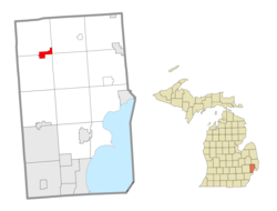
New Haven is a village in Lenox Township within Macomb County in the U.S. state of Michigan. The population was 6,097 at the 2020 census, up from 4,642 in 2010.

<span class="mw-page-title-main">Estral Beach, Michigan</span> Village in Michigan, United States

Estral Beach is a village in Monroe County in the U.S. state of Michigan. The population was 403 at the 2020 census. The village is located within Berlin Charter Township.

<span class="mw-page-title-main">Addison Township, Michigan</span> Civil township in Michigan, United States

Addison Township is a civil township of northeast Oakland County in the U.S. state of Michigan. As of the 2020 census, the township population was 6,256.

<span class="mw-page-title-main">Holly, Michigan</span> Village in Michigan, United States

Holly is a village in north Oakland County in the U.S. state of Michigan. The population was 5,997 at the 2020 census. The village is located within Holly Township. It is about 15 miles (24 km) south of Flint and 55 miles (89 km) northwest of Detroit.

<span class="mw-page-title-main">Orchard Lake Village, Michigan</span> City in Michigan, United States

The City of Orchard Lake Village is a city in Oakland County in the U.S. state of Michigan. A northern suburb of Detroit, Orchard Lake Village is located roughly 27 miles (43.5 km) from downtown Detroit, and about 3 miles (4.8 km) southwest of Pontiac. The city is mostly surrounded by West Bloomfield Township, with a small northeast border with Keego Harbor. As of the 2010 census, the city had a population of 2,375.

<span class="mw-page-title-main">Wolverine Lake, Michigan</span> Village in Michigan, United States

Wolverine Lake is a village in Oakland County in the U.S. state of Michigan. The population was 4,312 at the 2010 census. The village is located within Commerce Township.

<span class="mw-page-title-main">Spring Lake, Michigan</span> Village in Michigan, United States

Spring Lake is a village in Ottawa County in the U.S. state of Michigan. The population was 2,497 at the 2020 census. The village is located within Spring Lake Township; the two share a ZIP code.

<span class="mw-page-title-main">Roscommon, Michigan</span> Village in Michigan, United States

Roscommon is a village in and the county seat of Roscommon County, Michigan, United States. The population was 981 at the 2020 census.

<span class="mw-page-title-main">Byron, Michigan</span> Village in Michigan, United States

Byron is a village in Shiawassee County in the U.S. state of Michigan. The population was 581 at the 2010 census. The village is located within Burns Township.

<span class="mw-page-title-main">Capac, Michigan</span> Village in Michigan, United States

Capac is a village in Mussey Township, St. Clair County in the U.S. state of Michigan. The population was 1,890 at the 2010 census.

<span class="mw-page-title-main">Bloomingdale, Michigan</span> Village in Michigan, United States

Bloomingdale is a village in Van Buren County in the U.S. state of Michigan. The population was 454 at the 2010 census. The village is located within Bloomingdale Township and is the township seat.

Lennon is a village in the U.S. state of Michigan. The population was 511 at the 2010 census. The village is located along M-13 within Venice Township in Shiawassee County to the west and Clayton Township in Genesee County to the east.

<span class="mw-page-title-main">Washington Township, Macomb County, Michigan</span> Charter township in Michigan, United States

Washington Charter Township, located within Metro Detroit, is a charter township of Macomb County in the U.S. state of Michigan. The population was 28,165 at the 2020 census, up from 25,139 in 2010.

References

  1. 1 2 "2022 U.S. Gazetteer Files: Michigan". United States Census Bureau. Retrieved July 25, 2023.
  2. 1 2 U.S. Geological Survey Geographic Names Information System: Romeo, Michigan
  3. 1 2 "P1. Race – Romeo village, Michigan: 2020 DEC Redistricting Data (PL 94-171)". U.S. Census Bureau. Retrieved July 25, 2023.
  4. 1 2 "U.S. Census website". United States Census Bureau . Retrieved January 31, 2008.
  5. "Romeo Historical Society". Archived from the original on January 17, 2016. Retrieved July 7, 2011.
  6. "Our History – Romeo DDA".
  7. "Romeo Community Schools: Schools". Archived from the original on August 12, 2007. Retrieved October 22, 2007.
  8. DeBow, J.D.B. (1853). The Seventh Census of the United States: 1850 (PDF). Washington: Robert Armstrong. p. 1022. Retrieved January 28, 2022. This figure is a population estimate provided in the appendix of the official volume of the 1850 Census.
  9. "Census of Population and Housing". Census.gov. Retrieved June 4, 2015.
  10. "U.S. Census website". United States Census Bureau . Retrieved November 25, 2012.
  11. "Home - Michigan Lavender Festival". Michigan Lavender Festival.
  12. "Romeo Peach Festival". Romeo Peach Festival. Retrieved April 10, 2023.
  13. Rakowicz, Erica (October 10, 2015). "Mannheim Steamroller drummer to perform in hometown" . Retrieved January 30, 2020.