Lake St. Clair

Last updated

Lake St. Clair
LakeStClair sentinel2 (cropped).jpg
false-color imagery from Sentinel-2, showing Lake St. Clair in April 2023
Relief map of USA Michigan.png
Red pog.svg
Lake St. Clair
Location(Great Lakes)
Coordinates 42°28′N82°40′W / 42.467°N 82.667°W / 42.467; -82.667
Type Freshwater lake
Primary inflows St. Clair River, Thames River, Sydenham River, Clinton River, Pine River
Primary outflows Detroit River
Basin  countriesCanada, United States
Max. length26 mi (42 km) [1]
Max. width24 mi (39 km) [1]
Surface area430 sq mi (1,114 km2) [1] [2]
Average depth11 ft (3.4 m) [1]
Max. depth27 ft (8.2 m)
Water volume0.82 cu mi (3.4 km3) [1]
Residence time 7 days
Shore length1130 mi (210 km) plus 127 mi (204 km) for islands [3]
Surface elevation574 ft (175 m)
Islands Gull Island, Harsens Island, Strawberry Island Fantasy Island and Peche Island
Settlements Detroit
1 Shore length is not a well-defined measure.

Lake St. Clair (French : Lac Sainte-Claire) is a freshwater lake that lies between the Canadian province of Ontario and the U.S. state of Michigan. It was named in 1679 by French Catholic explorers after Saint Clare of Assisi, on whose feast day they first saw the lake.

Contents

It is part of the Great Lakes system (although not considered one of the five Great Lakes), and along with the St. Clair River and Detroit River, Lake St. Clair connects Lake Huron (to the north) with Lake Erie (to the south). It has a total surface area of about 430 square miles (1,100 km2) and an average depth of just 11 feet (3.4 m); to ensure an uninterrupted waterway, government agencies in both countries have maintained a 30-foot-deep (9.1 m) shipping channel through the shallow lake for more than a century.

Geography

This lake is situated about six miles (10 km) northeast of the downtown areas of Detroit, Michigan, and Windsor, Ontario. Along with the St. Clair River and Detroit River, Lake St. Clair connects Lake Huron (to its north) with Lake Erie (to its south). The area is notable for the fact that the Canadian territory around the lake (Windsor metropolitan area) lies south of the adjacent United States territory.

Lake St. Clair measures about 22.5 nautical miles (42 km; 26 mi) from north to south and about 21 nautical miles (39 km; 24 mi) from east to west. Its total surface area is about 430 square miles (1,100 km2). This is a rather shallow lake for its size, with an average depth of about 11 feet (3.4 m), and a maximum natural depth of 23 feet (7.0 m). However, it is 27 feet (8.2 m) deep in the navigation channel which is dredged for lake freighter passage by the U.S. Army Corps of Engineers. [1] [4] The lake is fed by the St. Clair River, which flows to the south from Lake Huron and has an extensive river delta where it enters Lake St. Clair. This is the largest delta of the Great Lakes System. [1]

Other rivers which feed Lake St. Clair are the Thames and Sydenham rivers which originate in Southwestern Ontario, and the Clinton River, which originates in Michigan. The outflow from Lake St. Clair travels from its southwestern end into the Detroit River, and then into Lake Erie.

The tarry time (i.e., the time between entering and leaving) of the water in Lake St. Clair averages about seven days, but this can vary from as little as two to as many as thirty days, depending on the direction of the winds, the water circulation patterns, and the amount of water that is flowing out of Lake Huron. For water flowing through the navigation channel, the time period is only about two days. [1]

Lake St. Clair is part of the Great Lakes system, but it is 17 times smaller than Lake Ontario by surface area, and more than 80 times by volume. It is rarely included in the list of "Great Lakes" but is sometimes referred to as "the sixth Great Lake". [1] [2] Scattered proposals have called for it to be officially recognized as a Great Lake, which might enable it to attract greater public funding for scientific research and other projects. [5]

Naming

Lac Sainte Claire historical marker, Saint Clair Shores, Michigan Lac Ste Claire sign SCS MICH.JPG
Lac Sainte Claire historical marker, Saint Clair Shores, Michigan

First Nations/Native Americans used the lake as part of their extensive navigation of the Great Lakes. The Mississauga called it Waawiyaataan(ong), meaning "(at) the whirlpool". The Wea derived their name from a Miami cognate: Waayaahtanonki.

In the latter part of the 17th century, the Mississauga established a village near the lake. Early French mapmakers had identified the lake by a variety of French and Iroquoian-language names, including Lac des Eaux de Mer [Seawater Lake]; Lac Ganatchio ("kettle," for its shape), in French Lac de la Chaudière. A variety of Native names were associated with sweetness, as the lake was freshwater as opposed to saltwater. These included Otsiketa (sugar or candy), Kandequio or Kandekio (possibly candy), Oiatinatchiketo (probably a form of Otsiketa), and Oiatinonchikebo. Similarly, the Iroquois nations called present-day Lake Huron a term meaning "The Grand Lake of the Sweet Sea" (fresh water as opposed to salt water.)

The French expressed this association on their maps as Mer Douce (sweet sea) and the Dutch identified it in Latin as Mare Dulce. [6]

On August 12, 1679, the French explorer René Robert Cavelier, Sieur de La Salle arrived with an expedition. He named the body of water Lac Sainte-Claire, as the expedition sighted it on the feast day of Saint Clare of Assisi. The historian on the voyage, Louis Hennepin, recorded that the Iroquoian tribes referred to the lake as Otseketa. [7]

As early as 1710, the English adopted the French name, identifying the lake on their maps as Saint Clare. By the Mitchell Map in 1755, the spelling appeared as the shorter "St. Clair," the form that became most widely used. [8] Some scholars credit the name as honoring the American Revolutionary War General Arthur St. Clair, later Governor of the Northwest Territory, but the name Lake St. Clair was in use with this current spelling long before St. Clair became a notable figure. Together the place name and general's name likely influenced settlers' naming a proliferation of nearby political jurisdictions: the Michigan county and township of St. Clair, as well as the cities of St. Clair and St. Clair Shores.

Some local historians attributed the namesake to Patrick Sinclair, a British officer who purchased land on the St. Clair River at the outlet of the Pine River. There, in 1764, he built Fort Sinclair, which was in use for nearly twenty years before being abandoned. [9]

Unlike most smaller lakes in the region—but like the Great Lakes—Lake comes at the front of its proper name, rather than the end; this is reflective of its French origins.

Human history

The Crawford Knoll Site located on the eastern branch of the St. Clair River delta uncovered bone and projectile points dating back to 1500 to 1000 BCE which suggest seasonal usage by the local Indigenous population. [10]

Water quality

Lake St Clair's location, downstream from the largest freshwater delta in the Great Lakes, has a large effect on its turbidity (clarity). Current water quality is quite good despite past incidents and a history of chemical bio-accumulation. A number of cities source drinking water from or just downstream of the lake and quality is closely monitored. [11] [12]

In the early 1970s, the Canadian and American governments closed the commercial fishery over concerns of bio-accumulation of mercury. The industry responsible for this contamination was the Dow Chemical Chlor-Alkali Plant in Sarnia, Ontario. Since 1949, Dow Chemical had been operating mercury cell plants for the production of chlorine and other chemicals. Through its production process, it discharged mercury into the river and contaminated the fishery. The fishery has since not been re-opened, although studies have now confirmed mercury levels are well within the safe range. [13]

Sport fishing remains popular in the lake. The governments on both sides of the lakes continue to monitor and publish guides for sport fish consumption. [14] [15]

Boat clubs

Grosse Pointe Yacht Club Grosse Pointe yacht club.jpg
Grosse Pointe Yacht Club
Sunset on Lake St. Clair Sailing sunset on Lake St. Clair.jpg
Sunset on Lake St. Clair

Many yacht clubs (boating and sailing clubs) are located along the shores. Some of these include:

Public beaches

Beach on Lake St. Clair near St. Clair Shores St Clair shores beach.jpg
Beach on Lake St. Clair near St. Clair Shores
Welcoming boaters along Black Creek Metro beach.jpg
Welcoming boaters along Black Creek

See also

Related Research Articles

<span class="mw-page-title-main">Detroit River</span> River connecting Lake Huron with Lake Erie

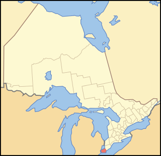
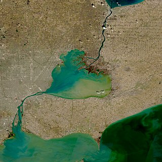
The Detroit River flows west and south for 24 nautical miles from Lake St. Clair to Lake Erie as a strait in the Great Lakes system. The river divides the metropolitan areas of Detroit, Michigan, and Windsor, Ontario—an area collectively referred to as Detroit–Windsor—and forms part of the border between Canada and the United States. The Ambassador Bridge, the Detroit–Windsor Tunnel, and the Michigan Central Railway Tunnel connect the cities.

<span class="mw-page-title-main">Great Lakes</span> Group of lakes in North America

The Great Lakes, also called the Great Lakes of North America, are a series of large interconnected freshwater lakes in the east-central interior of North America that connect to the Atlantic Ocean via the Saint Lawrence River. The five lakes are Superior, Michigan, Huron, Erie, and Ontario, and they are in general on or near the Canada–United States border. Hydrologically, Michigan and Huron are a single body of water joined at the Straits of Mackinac. The Great Lakes Waterway enables modern travel and shipping by water among the lakes.

<span class="mw-page-title-main">Lake Huron</span> One of the Great Lakes of North America

Lake Huron is one of the five Great Lakes of North America. It is shared on the north and east by the Canadian province of Ontario and on the south and west by the U.S. state of Michigan. The name of the lake is derived from early French explorers who named it for the indigenous people they knew as Huron (Wyandot) inhabiting the region. Hydrologically, Lake Huron comprises the eastern portion of Lake Michigan–Huron, having the same surface elevation as Lake Michigan, to which it is connected by the 5-mile-wide (8.0 km), 20-fathom-deep Straits of Mackinac. Combined, Lake Michigan–Huron is the largest freshwater lake by area in the world. The Huronian glaciation was named from evidence collected from Lake Huron region. The northern parts of the lake include the North Channel and Georgian Bay. Saginaw Bay is located in the southwest corner of the lake. The main inlet is the St. Marys River, and the main outlet is through the St. Clair River to Lake Erie. Lake Huron has a fairly large drainage basin covering parts of Michigan and Ontario. Water flows through Lake Huron faster than the other Great Lakes with a retention time of only 22 years.

<span class="mw-page-title-main">St. Clair County, Michigan</span> County in Michigan, United States

St. Clair County is a county located in the U.S. state of Michigan and bordering the west bank of the St. Clair River. As of the 2020 census, the population was 160,383. It is the 13th-most populous county in the state. The county seat is Port Huron, located at the north end of the St. Clair River at Lake Huron. The county was created September 10, 1820, and its government was organized in 1821. It is located northeast of Detroit. It is considered by the State of Michigan to be a part of The Thumb, a peninsula that is surrounded by Lake Huron in the east-central area of the state. This area is sometimes dubbed the Blue Water Area.

<span class="mw-page-title-main">Essex County, Ontario</span> County in Ontario, Canada

Essex County is a primarily rural county in Southwestern Ontario, Canada comprising seven municipalities: Amherstburg, Kingsville, Lakeshore, LaSalle, Leamington, Tecumseh and the administrative seat, Essex.

<span class="mw-page-title-main">St. Clair River</span> River in North America

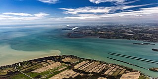
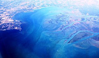
The St. Clair River is a 40.5-mile-long (65.2 km) river in central North America which flows from Lake Huron into Lake St. Clair, forming part of the international boundary between Canada and the United States and between the Canadian province of Ontario and the U.S. state of Michigan. The river is a significant component in the Great Lakes Waterway, whose shipping channels permit cargo vessels to travel between the upper and lower Great Lakes.

<span class="mw-page-title-main">The Thumb</span> Peninsula and region of Michigan

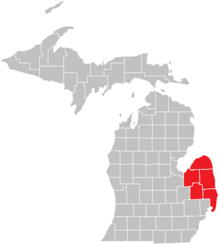
The Thumb is a region and a peninsula of the U.S. state of Michigan, so named because the Lower Peninsula is shaped like a mitten. The Thumb area is generally considered to be in the Central Michigan region, east of the Flint area and the Tri-Cities and north of Metro Detroit. The region is also branded as the Blue Water Area.

<span class="mw-page-title-main">Grosse Pointe Yacht Club</span> Historic yacht club in Grosse Pointe, Michigan

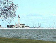
The Grosse Pointe Yacht Club (GPYC) is a private yacht club located on the shore of Lake St. Clair in Grosse Pointe Shores, Michigan. The club is a member of the Detroit Regional Yacht-racing Association (DRYA). The clubhouse is prominently visible and a well-known landmark along the shoreline of the lake north of Detroit.

<span class="mw-page-title-main">Harsens Island</span> Location in Michigan, United States

Harsens Island is a wet marshy location at the mouth of the St. Clair River on Lake St. Clair, in the U.S. state of Michigan. Politically, the island is in Clay Township of St. Clair County.

<span class="mw-page-title-main">Clare Jacobs</span> American pole vaulter

Clare Stephen Jacobs was an accomplished businessman, yacht racer, and American track athlete who competed mainly in the pole vault and won an Olympic Bronze medal in the sport in 1908. He was born in Madison, Dakota Territory.

The Detroit Regional Yacht-racing Association (DRYA) was established in 1912 as the Detroit River Yachting Association by the Commodores of the Detroit Boat Club and the Detroit Yacht Club, Commodore Harry Austin and Commodore Harry Kendall, respectively.

<span class="mw-page-title-main">Lake Erie Basin</span> Drainage basin of Lake Erie in North America

Lake Erie Basin consists of Lake Erie and surrounding watersheds, which are typically named after the river, creek, or stream that provides drainage into the lake. The watersheds are located in the states of Indiana, Michigan, New York, Ohio, and Pennsylvania in the United States, and in the province of Ontario in Canada. The basin is part of the Great Lakes Basin and Saint Lawrence River Watershed, which feeds into the Atlantic Ocean. 80% of the lake's water flows in from the Detroit River, with only 9% coming from all of the remaining watersheds combined. A littoral zone serves as the interface between land and lake, being that portion of the basin where the lake is less than 15 feet (4.6 m) in depth.

<span class="mw-page-title-main">Pointe Mouillee State Game Area</span> Protected area in Michigan, U.S.

Pointe Mouillee State Game Area is a state game area in the U.S. state of Michigan. It encompasses 7,483 acres (30.3 km2) of hunting, recreational, and protected wildlife and wetland areas at the mouth of the Huron River at Lake Erie, as well as smaller outlying areas within the Detroit River. Pointe Mouillee State Game Area was established in 1945 and is administered by the Michigan Department of Natural Resources.

<span class="mw-page-title-main">Anchor Bay (Michigan)</span> Freshwater bay, part of Lake St. Clair in Michigan

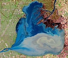
Anchor Bay is a freshwater bay forming the northern region of Lake St. Clair in the U.S. state of Michigan. It generally encompasses the waters north of a line between Huron Point and the Middle Channel of the St. Clair River. It covers over 90 square miles (230 km2) and a depth of from 1 to 11 feet, which is unusually shallow for its immense size.

References

  1. 1 2 3 4 5 6 7 8 9 "Lake St. Clair summary report" (PDF). Great Lakes.net. Archived from the original (PDF) on April 16, 2016. Retrieved December 2, 2007.
  2. 1 2 "Chapter 1:Introduction to Lake St. Clair and the St. Clair River". United States Army Corps of Engineers. June 2004. Archived from the original on January 10, 2009. Retrieved June 8, 2008.
  3. "Shorelines of the Great Lakes". Michigan Department of Environmental Quality. Archived from the original on April 5, 2015.
  4. "Bathymetry of Lake Erie and Lake St. Clair" (PDF). NOAA . Retrieved June 6, 2019.
  5. Jones, Terril Yue (October 20, 2002). "Movement Would Thrust Greatness on Lake St. Clair". Los Angeles Times .
  6. Jenks, William Lee (2005) [1912]. "Origin of Name". St. Clair County, Michigan, its history and its people. Ann Arbor: University of Michigan Library. p.  24 . Retrieved November 23, 2007.
  7. Jenks (2005) , p.  22 .
  8. Jenks (2005) , pp.  cc=micounty, rgn=full%20text, idno=bad1042.0001.001, didno=BAD1042.0001.001, view=image, seq=63, page=root, size=s, frm=frameset, 23–24 .
  9. Fuller, George Newman (2005) [1926?]. "Indians and Explorations". Local History and Personal Sketches of St. Clair and Shiawassee Counties. Ann Arbor: University of Michigan Library. pp.  cc=micounty, rgn=full%20text, idno=ARH7752.0001.001, didno=ARH7752.0001.001, view=image, seq=00000017 21–22 . Retrieved November 23, 2007.
  10. Kenyon, Ian T.; Snarey, Kristy (January 2002). "The Crawford Knoll Site" (PDF). Newsletter of the London Chapter, Ontario Archaeological Society.
  11. "Water Quality in Windsor". City of Windsor. Archived from the original on February 16, 2015. Retrieved August 23, 2017.
  12. "Thames–Sydenham Source Protection Region". Thames-Sydenham and Region Source Water Protection. Retrieved February 15, 2015.
  13. "Mercury in Lake St. Clair Walleye". United States Environmental Protection Agency. Archived from the original on September 24, 2015. Retrieved February 15, 2015.
  14. "Eating Ontario Fish". Ministry of the Environment and Climate Change . Retrieved August 23, 2017.
  15. "Eating Fish from Michigan's Lakes & Rivers". Michigan Department of Health and Human Services . Retrieved August 23, 2017.
  16. "Crescent Sail Yacht Club" . Retrieved February 15, 2015.
  17. "Clinton River Boat Club" . Retrieved August 12, 2015.
  18. "Albatross Yacht Club" . Retrieved February 15, 2015.
  19. "North Star Sail Club" . Retrieved February 4, 2015.
  20. "Lakeshore Sail Club" . Retrieved February 15, 2015.
  21. "South Port Sailing Club". Archived from the original on February 4, 2015. Retrieved February 4, 2015.
  22. "St. Clair Sail Club". Archived from the original on February 16, 2015. Retrieved February 15, 2015.
  23. "Thames River Yacht Club" . Retrieved February 4, 2015.

Further reading