Lake Michigan is one of the five Great Lakes of North America. It is the second-largest of the Great Lakes by volume and the third-largest by surface area, after Lake Superior and Lake Huron. To the east, its basin is conjoined with that of Lake Huron through the narrow Straits of Mackinac, giving it the same surface elevation as its easterly counterpart; the two are technically a single lake.

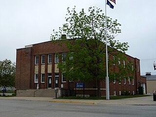
Escanaba, commonly shortened to Esky, is a port city in Delta County in the U.S. state of Michigan, located on Little Bay de Noc in the state's Upper Peninsula. The population was 12,616 at the 2010 census, making it the third-largest city in the Upper Peninsula after Marquette and Sault Ste. Marie. It is the seat of government of Delta County.

Fairbanks Township is a civil township of Delta County in the U.S. state of Michigan. As of the 2010 census, the township population was 281, down from 321 at the 2000 census.

Garden Township is a civil township of Delta County in the U.S. state of Michigan. As of the 2010 census, the township had a total population of 750, down from 817 at the 2000 census. In 2012, it became home to the first wind farm in the Upper Peninsula, the 28 MW Garden Wind Farm.
Gladstone is a city in Delta County in the U.S. state of Michigan. First settled in 1877, Gladstone's original name was Minnewasca. The population was 4,973 at the 2010 census.
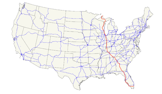
U.S. Route 41, also U.S. Highway 41 (US 41), is a major north–south United States Numbered Highway that runs from Miami, Florida, to the Upper Peninsula of Michigan. Until 1949, the part in southern Florida, from Naples to Miami, was US 94. The highway's southern terminus is in the Brickell neighborhood of Downtown Miami at an intersection with Brickell Avenue (US 1), and its northern terminus is east of Copper Harbor, Michigan, at a modest cul-de-sac near Fort Wilkins Historic State Park at the tip of the Keweenaw Peninsula. US 41 closely parallels Interstate 75 (I-75) from Naples, Florida, all the way through Georgia to Chattanooga, Tennessee.
The Thumb is a region and a peninsula of the U.S. state of Michigan, so named because the Lower Peninsula is shaped like a mitten. The Thumb area is generally considered to be in the Central Michigan region, east of the Tri-Cities and north of Metro Detroit. The region is also branded as the Blue Water Area.
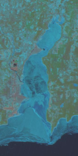
Little Bay de Noc is a bay in the Upper Peninsula of the U.S. state of Michigan. The bay opens into Lake Michigan's Green Bay.

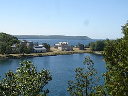
Fayette Historic State Park is the state park of the historic town of Fayette in the U.S. state of Michigan. It is located on the Big Bay de Noc of Lake Michigan, between Snail Shell Harbor and Sand Bay, on the southern side of the Upper Peninsula, about 17 miles south of US 2. Fayette was the site of an industrial community that manufactured charcoal pig iron between 1867 and 1891. The town has been reconstructed into a living museum, showing what life was like in this town in the late 19th century. It was listed on the National Register of Historic Places in 1970.

The Door Peninsula is a peninsula in eastern Wisconsin, separating the southern part of the Green Bay from Lake Michigan. The peninsula includes northern Kewaunee County, northeastern Brown County, and the mainland portion of Door County. It is on the western side of the Niagara Escarpment. Well known for its cherry and apple orchards, the Door Peninsula is a popular tourism destination. With the 1881 completion of the Sturgeon Bay Ship Canal, the northern half of the peninsula became an island.

Washington Island is an island of the state of Wisconsin situated in Lake Michigan. Lying about 7 miles (11 km) northeast of the tip of the Door Peninsula, it is part of Door County, Wisconsin. The island has a year-round population of 708 people according to the 2010 census. It has a land area of 60.89 km² and comprises over 92 percent of the land area of the town of Washington, as well as all of its population. The unincorporated community of Detroit Harbor is situated on the island. It is the largest in a group of islands that includes Plum, Detroit, Hog, Pilot, Fish, and Rock Islands. These islands form the Town of Washington. Detroit Harbor bay is on the south side of the island. A large part of Washington Island's economy is based on tourism.

The Garden Peninsula is a peninsula of 22 miles (35 km) in length that extends southwestward into Lake Michigan from the mainland of Michigan's Upper Peninsula. The peninsula is bordered by Lake Michigan on the east, and by Big Bay de Noc on the west. The base of the peninsula is served by U.S. Highway 2, and the peninsula's west shore is reached by M-183. The largest settlement on the peninsula is Garden, Michigan.
M-183 is a north–south state trunkline highway in the Upper Peninsula of the US state of Michigan. It serves Fayette State Park as an access route from US Highway 2 (US 2). The highway runs through rural farmlands of the Garden Peninsula and next to Big Bay de Noc, a bay of Lake Michigan. The community at Fayette dates back to the 1860s. It has been a state park since the late 1950s, and the connecting road has been a state highway since the 1980s.
The Peninsula Point Light is a lighthouse located at the southern tip of the Stonington Peninsula in Bay de Noc township in Delta County, Michigan. United States Coast Guard historical documents have over the years listed the name of the site as both Peninsula Point and Point Peninsula.
Summer Island is an island in Lake Michigan, 2.5 miles (4 km) miles off the southern tip of the Garden Peninsula in the U.S. state of Michigan. It can easily be seen from Fairport, on the southern end of Delta County Road 483, the locally maintained extension of M-183, but is not accessible to the public.
The Potawatomi Islands is the most common historic name given to the string of islands that delineate the transition from Green Bay to Lake Michigan, one of the Great Lakes. The archipelago is also termed the "Grand Traverse Islands".

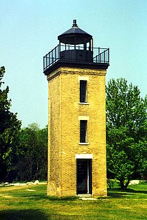
The Sand Point Lighthouse is located in Escanaba, Michigan, United States, on Lake Michigan's northern shore. Since 1989, it has been an unofficial aid to navigation. Though it is an operational aid to navigation. The restored lighthouse is now open to the public during the summer months. It is also known as the Escanaba/Sand Point Light or the Escanaba Light.
The Great Lakes Circle Tour is a designated scenic road system connecting all of the Great Lakes and the St. Lawrence River. It consists of routes for circumnavigating the lakes, either individually or collectively.
St. Vital Island is an island in Bay De Noc Township, Delta County, Michigan. The island is located in Big Bay de Noc in Lake Michigan. It is 20.52 acres (8.30 ha) in size and under a half mile from the Stonington Peninsula shore. St. Vital Island is uninhabited and owned by the United States Forest Service. It is part of the Hiawatha National Forest. The island is home to a small colony of nesting Common terns and Black-crowned night herons.