
The Wyandot people, or Wyandotte and Waⁿdát, are an Indigenous peoples of the Northeastern Woodlands. The Wyandot are Iroquoian Indigenous peoples of North America who emerged as a confederacy of tribes around the north shore of Lake Ontario with their original homeland extending to Georgian Bay of Lake Huron and Lake Simcoe in Ontario, Canada and occupying some territory around the western part of the lake.

Georgian Bay is a large bay of Lake Huron, in the Laurentia bioregion. It is located entirely within the borders of Ontario, Canada. The main body of the bay lies east of the Bruce Peninsula and Manitoulin Island. To its northwest is the North Channel.

The Mississauga are a subtribe of the Anishinaabe-speaking First Nations peoples located in southern Ontario, Canada. They are closely related to the Ojibwe. The name "Mississauga" comes from the Anishinaabe word Misi-zaagiing, meaning "[Those at the] Great River-mouth." It is closely related to the Ojibwe word Misswezahging, which means ‘a river with many outlets.’

Collingwood is a town in Simcoe County, Ontario, Canada. It is situated on Nottawasaga Bay at the southern point of Georgian Bay. Collingwood is well known as a tourist destination, for its skiing in the winter, and limestone caves along the Niagara Escarpment in the summer.

Simcoe County is located in the central portion of Southern Ontario, Canada. The county is just north of the Greater Toronto Area, stretching from the shores of Lake Simcoe in the east to Georgian Bay in the west. Simcoe County forms part of the Greater Golden Horseshoe area, a densely populated and industrialized region, centred on the Greater Toronto Area.

Ontario came into being as a province of Canada in 1867 but historians use the term to cover its entire history. This article also covers the history of the territory Ontario now occupies.

The Grand River, formerly known as The River Ouse, is a large river in Ontario, Canada. It lies along the western fringe of the Greater Golden Horseshoe region of Ontario which overlaps the eastern portion of southwestern Ontario, sometimes referred to as Midwestern Ontario, along the length of this river. From its source near Wareham, Ontario, it flows south through Grand Valley, Fergus, Elora, Waterloo, Kitchener, Cambridge, Paris, Brantford, Caledonia, and Cayuga before emptying into the north shore of Lake Erie south of Dunnville at Port Maitland. One of the scenic and spectacular features of the river is the falls and Gorge at Elora.

The Nottawasaga River is a river in Simcoe County and Dufferin County in Central Ontario, Canada. It is part of the Great Lakes Basin, and is a tributary of Lake Huron. The river flows from the Orangeville Reservoir in the town of Orangeville, Dufferin County, through the Niagara Escarpment and the Minesing Wetlands, the latter a wetland of international significance, and empties into Nottawasaga Bay, an inlet of Georgian Bay on Lake Huron, at the town of Wasaga Beach, Simcoe County.

Wasaga Beach is a town in Simcoe County, Ontario, Canada. Situated along the longest freshwater beach in the world, it is a popular summer tourist destination. It is located along the southern end of Georgian Bay, approximately 150 km (93 mi) north of Toronto and about 40 km (25 mi) northwest of Barrie. To the west, Collingwood and The Blue Mountains also attract visitors much of the year. The town is situated along a very long sandy beach on Nottawasaga Bay in Georgian Bay and the winding Nottawasaga River. The beaches are part of the Wasaga Beach Provincial Park; the park area totals 168 hectares. Wasaga Beach has a year-round population of 24,862 as of 2021, but during the summer months the population increases with many seasonal residents.

Clearview is a rural incorporated township in Simcoe County in Central Ontario, Canada, west of Barrie and south of Collingwood and Wasaga Beach in Simcoe County.

The Neutral Confederacy were an Iroquoian people who lived in what is now southwestern and south-central Ontario in Canada, North America. They lived throughout the area bounded by the southern half of Lake Huron, the entire northern shoreline of Lake Erie, from the Detroit River in the west to the Niagara River in the east, plus northward around the western end of Lake Ontario. Their territory was southwest of the Petun and west of the southern area of the Huron people, or Wendat territory.
King's Highway 26, commonly referred to as Highway 26, is a provincially maintained highway in the Canadian province of Ontario, connecting the cities of Owen Sound and Barrie. Between these two cities, the highway serves the southern shoreline of Georgian Bay, passing through Meaford, Collingwood and Stayner, as well as passing the Blue Mountain Resort. In addition, the highway serves as the main route to Wasaga Beach, a popular recreational destination during the summer months.

The Blue Mountains is a town in Grey County, southwestern Ontario, Canada, located where the Beaver River flows into Nottawasaga Bay. It is named for the Blue Mountain, and hence the economy of the town is centred on tourism, particularly on the Blue Mountain ski resort and the private Georgian Peaks, Osler, Craigleith and Alpine Ski Clubs.

The Petun, also known as the Tobacco people, Wenro, or Tionontati, were an indigenous Iroquoian people of the woodlands of eastern North America. Their last known traditional homeland was south of Lake Huron's Georgian Bay, in what is today's Canadian province of Ontario, but prior to the Beaver Wars, the tribe was living in New York, between the Genessee and Niagara Rivers.
Huronia is a historical region in the Great Lakes area of eastern North America. It is positioned between Lakes Erie, Ontario, and Huron. Similarly to the latter, it takes its name from the Huron, an Iroquoian society that flourished in the years leading up to contact with Europeans.
King's Highway 92, also known as Highway 92, was a provincially maintained highway in the Canadian province of Ontario. The route connected Highway 26 west of Wasaga Beach with Highway 27 in Elmvale. Highway 92 was established in 1936, although it did not extend through Wasaga Beach to Highway 26 until the early 1980s. The entire route was downloaded in 1997 and transferred to Simcoe County. Today, the section of the former highway outside Wasaga Beach is known as Simcoe County Road 92.
Bead Hill is an archaeological site comprising the only known remaining and intact 17th-century Seneca site in Canada. It is located along the Toronto Carrying-Place Trail on the banks of the Rouge River in Rouge Park, a city park in Toronto, Ontario. Because of its sensitive archaeological nature, it is not open to the public, nor readily identified in the park. It was designated a National Historic Site of Canada in 1991.
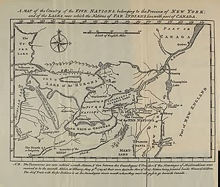
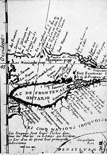
Between 1665 and 1670, seven Iroquois settlements on the north shore of Lake Ontario in present-day Ontario, collectively known as the "Iroquois du Nord" villages, were established by Senecas, Cayugas, and Oneidas. The villages consisted of Ganneious, Kente, Kentsio, Ganaraske, Ganatsekwyagon, Teiaiagon, and Quinaouatoua. The villages were all abandoned by 1701.

The Beaver River is a river in Grey County and Simcoe County in Southern Ontario, Canada. It is part of the Great Lakes Basin, and is a tributary of Lake Huron. The river's drainage basin is under the auspices of Grey Sauble Conservation.

Duffins Creek is a waterway in the eastern end of the Greater Toronto Area in Ontario, Canada. The watershed of the Duffins Creek is part of the Durham Region and the York Region.

