
Elephant Island is an ice-covered, mountainous island off the coast of Antarctica in the outer reaches of the South Shetland Islands, in the Southern Ocean. The island is situated 245 kilometres north-northeast of the tip of the Antarctic Peninsula, 1,253 kilometres west-southwest of South Georgia, 935 kilometres south of the Falkland Islands, and 885 kilometres southeast of Cape Horn. It is within the Antarctic claims of Argentina, Chile and the United Kingdom.

Bird Island is 4.8 kilometres (3 mi) long and 800 metres (875 yd) wide, separated from the western end of South Georgia by Bird Sound. It is part of the British overseas territory of South Georgia and the South Sandwich Islands, also claimed by Argentina as part of Tierra del Fuego province.

Tower Island is an Antarctic island 9 kilometres (5 nmi) long and 305 m (1,001 ft) high. It marks the north-east extent of Palmer Archipelago. It lies 37 kilometres (20 nmi) north-east of Trinity Island, separated by Gilbert Strait. Both islands are separated from the Davis Coast to the south by Orléans Strait, running northeast–southwest. The Pearl Rocks lie off the West Coast of Tower Island.

The Traversay Islands are a group of three islands—Zavodovski, Leskov and Visokoi—at the northern end of the South Sandwich Islands.
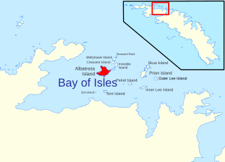
Albatross Island is an island 2 miles (3 km) southeast of Cape Buller, lying in the Bay of Isles, South Georgia. Charted in 1912–13 by Robert Cushman Murphy, American naturalist aboard the brig Daisy, who gave this name because he observed albatrosses there. The eastern headland of the island is called The Pricker, a name which first appeared on a 1931 British Admiralty chart.
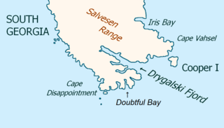
Cooper Island is a small island, 2 miles (3.2 km) long, which lies at the north side of the entrance to Drygalski Fjord, off the southeast end of South Georgia. It was discovered by a British expedition under James Cook in 1775, and named for Lieutenant Robert Palliser Cooper, an officer aboard HMS Resolution.

Annenkov Island is an island in South Georgia and the South Sandwich Islands, to the west of the main island of South Georgia. The Pickersgill Islands are to its southeast. It is irregularly shaped and 4 miles (6.4 km) long and 650 m (2,130 ft) high, lying 8 miles (13 km) off the south-central coast of South Georgia.

Cumberland West Bay is a bay forming the western arm of Cumberland Bay, South Georgia. It is entered southward of Larsen Point, where it is 2.5 miles (4 km) wide and extends 7 miles (11 km) in a southwest direction. It is separated from Cumberland East Bay by Thatcher Peninsula. Papua Beach is situated on its southeast shore.

Cape Buller is a rugged headland forming the west side of the entrance to the Bay of Isles on the north coast of South Georgia. It was discovered and named in 1775 by a British expedition under James Cook.
You may be looking for Undine South Harbour near Ducloz Head, South Georgia
Prion Island is an island 2.4 km (1.5 mi) north-northeast of Luck Point, lying in the Bay of Isles, South Georgia. It was charted in 1912-13 by Robert Cushman Murphy, American naturalist aboard the brig Daisy, and so named because he observed prions on the island.
The Samuel Islands are a group of small islands and rocks lying close to the south coast of South Georgia, 1.6 km west-southwest of Nilse Hullet and 3.2 km east-southeast of Klutschak Point. Surveyed by the SGS in the period 1951–57. Named by the United Kingdom Antarctic Place-Names Committee (UK-APC) after the catcher Don Samuel, built in 1925 and later owned by the Compania Argentina de Pesca, Grytviken, which sank in the vicinity of these islands in 1951.
Mollyhawk Island is a small, tussock-covered island lying between Seaward Rock and Crescent Island in the northern part of the Bay of Isles, South Georgia. It was charted in 1912–13 by Robert Cushman Murphy, an American naturalist aboard the brig Daisy. The island was surveyed in 1929–30 by Discovery Investigations personnel and named in association with Albatross Island, Prion Island and other natural history names in the Bay of Isles given by Murphy, "mollyhawk" being a name for a type of young gull.
The Bay of Isles is a bay 9 miles (14 km) wide and receding 3 miles (5 km), lying between Cape Buller and Cape Wilson along the north coast of South Georgia. It was discovered in 1775 by a British expedition under James Cook and so named by him because numerous islands lie in the bay. Of South Georgia's 31 breeding bird species, 17 are found here.
Skua Island is an island immediately northeast of Prion Island in the entrance to the Bay of Isles, South Georgia. Charted in 1912-13 by Robert Cushman Murphy, American naturalist aboard the brig Daisy. Surveyed in 1929-30 by DI personnel and named in association with Albatross Island, Prion Island and other natural history names given in the Bay of Isles by Murphy in 1912–13.
Tern Island in the south part of the Bay of Isles, South Georgia is a small, tussock-covered island lying 1.6 km south of Albatross Island and 10 km east of Dot Island.

Larsen Harbour is a narrow 2.6 miles (4.2 km) long inlet of indenting volcanic rocks and sheeted dykes known as the Larsen Harbour Formation. It is a branch of Drygalski Fjord, entered 2.5 miles (4 km) west-northwest of Nattriss Head, at the southeast end of South Georgia Island. It was charted by the Second German Antarctic Expedition, 1911–12, under Filchner, who named it for Captain Carl Anton Larsen a Norwegian explorer, who made significant contributions to the exploration of Antarctica. The most significant of these was the first discovery of fossils on the continent, for which he received the Back Grant from the Royal Geographical Society. Larsen is also considered the founder of the Antarctic whaling industry and the settlement and whaling station of Grytviken, South Georgia.
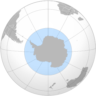
The Southern Ocean, also known as the Antarctic Ocean, comprises the southernmost waters of the world ocean, generally taken to be south of 60° S latitude and encircling Antarctica. With a size of 20,327,000 km2 (7,848,000 sq mi), it is regarded as the second-smallest of the five principal oceanic divisions: smaller than the Pacific, Atlantic, and Indian oceans but larger than the Arctic Ocean. Since the 1980s, the Southern Ocean has been subject to rapid climate change, which has led to changes in the marine ecosystem.
Blue Whale Harbour is a small, sheltered anchorage entered 1 nautical mile (2 km) west-southwest of Cape Constance, along the north coast of South Georgia Island. It was charted in 1930 by Discovery Investigations personnel, along with its constituent features. It is named for the blue whale, a commercially important species which was once widely distributed in polar and subpolar waters; numbers are now very small.
The Burdwood Bank, called Namuncurá in Argentina and other countries, is an undersea bank with a prominence of approximately 200 metres, part of the Scotia Arc projecting some 600 km (370 mi) from Cape Horn in the South Atlantic Ocean and located some 200 kilometres (120 mi) south of the Falkland Islands. Argentina claims economic rights over the whole of the bank, while the United Kingdom has designated about half of the bank as part of the Falklands Outer Economic Zone.
