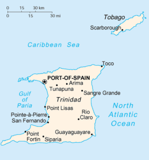
Port of Spain, officially the City of Port of Spain, is the capital city of Trinidad and Tobago and the country's second-largest city after San Fernando and the third largest municipality after Chaguanas and San Fernando. The city has a municipal population of 37,074, an urban population of 81,142 and a transient daily population of 250,000. It is located on the Gulf of Paria, on the northwest coast of the island of Trinidad and is part of a larger conurbation stretching from Chaguaramas in the west to Arima in the east with an estimated population of 600,000.

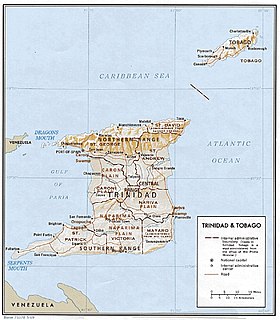
Trinidad is the larger and more populous of the two major islands of Trinidad and Tobago. The island lies 11 km (6.8 mi) off the northeastern coast of Venezuela and sits on the continental shelf of South America. It is often referred to as the southernmost island in the Caribbean. With an area of 5,131 km2 (1,981 sq mi), it is also the fifth largest in the West Indies.

The Borough of Chaguanas is the largest borough and fastest-growing town in Trinidad and Tobago. Located in west-central Trinidad, south of Port of Spain, north of Couva and San Fernando, named after the indigenous tribe who originally settled there, it grew in size due to its proximity to the Woodford Lodge sugar refinery. It remained a minor town until the 1980s when it began to grow rapidly as it drew people for its bargain shopping and moderately priced housing. Its rapid growth has seen property values increase dramatically, however.

Arima, officially The Royal Chartered Borough of Arima is the easternmost and second largest in area of the three boroughs of Trinidad and Tobago. It is geographically adjacent to Sangre Grande and Arouca at the south central foothills of the Northern Range. To the south is the Caroni–Arena Dam. Coterminous with Town of Arima since 1888, the borough of Arima is the fourth-largest municipality in population in the country. The census estimated it had 33,606 residents in 2011.

The Northern Range is the range of tall hills across north Trinidad, the major island in the Republic of Trinidad and Tobago. The hills range from the Chaguaramas peninsula on the west coast to Toco in the east. The Northern Range covers approximately twenty-five percent of the land area of Trinidad.

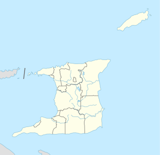
Caroni County is a historic county of Trinidad and Tobago. It occupies 557 km2 (215 sq mi) in the west central part of the island of Trinidad, the larger island in the Republic of Trinidad and Tobago. It lies south and southwest of Saint George County, west of Nariva County and north of Victoria County. To the west it is bounded by the Gulf of Paria. County Caroni includes the towns of Chaguanas, the largest town in the country and Couva, the capital of the Couva–Tabaquite–Talparo region. Administratively it is divided between the Borough of Chaguanas, the Couva–Tabaquite–Talparo Regional Corporation and the Tunapuna–Piarco Regional Corporation. The county was divided into four Wards: Chaguanas, Couva, Cunupia and Montserrat. The major towns of County Caroni are Chaguanas and Couva. The port and industrial zone of Point Lisas is located in Caroni, and the region is also a site for agriculture.

San Juan is a town in Trinidad and Tobago. Located in San Juan–Laventille region in Saint George County, it lies within the East-West Corridor Metropolitan Area, between Barataria and Saint Joseph.

Piarco is a town in northern Trinidad and is the site of Piarco International Airport.

Arouca is a town in the East–West Corridor of Trinidad and Tobago located 19 km (12 mi) east of Port of Spain, along the Eastern Main Road. It is located west of Arima, east of Tunapuna and Tacarigua, south of Lopinot, and north of Piarco. It is governed by the Tunapuna–Piarco Regional Corporation. Arouca may be a corruption of Arauca, an Amerindian tribe.
Victoria was a county on Trinidad island in Trinidad and Tobago.

The counties of Trinidad and Tobago are historic administrative divisions of Trinidad and Tobago. Trinidad was divided into eight counties, and these counties were subdivided into wards. Tobago was administered as a ward of Saint David County.

Piarco International Airport is an international airport serving the island of Trinidad and is one of two international airports in Trinidad and Tobago. The airport is located 30 km (19 mi) east of Downtown Port of Spain, located in the adjacent town of Piarco. It is the seventh busiest airport in the Caribbean in terms of passengers served and third busiest in the English-speaking Caribbean, after Sangster International Airport and Lynden Pindling International Airport. The airport is also the primary hub and operating base for the country's national airline, as well as the Caribbean's largest airline, Caribbean Airlines.

Trinidad and Tobago, officially the Republic of Trinidad and Tobago, is the southernmost island country in the Caribbean and is known for its fossil-fuel wealth. Consisting of the main islands Trinidad and Tobago, and numerous much smaller islands, it is situated 130 kilometres south of Grenada and 11 kilometres off the coast of northeastern Venezuela. It shares maritime boundaries with Barbados to the northeast, Grenada to the northwest, Guyana to the southeast, and Venezuela to the south and west.

Tunapuna–Piarco is one of the 9 regions of Trinidad and Tobago. It is the most populous region in the country by total population and the fifth-largest by total land area. Geographically located in Northern Trinidad, Tunapuna–Piarco shares its borders with the regions of San Juan–Laventille to the west, Couva–Tabaquite–Talparo to the south, the Borough of Chaguanas to the south-west, Sangre Grande to the east and the Caribbean Sea to the north. The region also completely surrounds the Royal Chartered Borough of Arima, which is located in the south-eastern corner of the region.

General elections were held in Trinidad and Tobago on 5 November 2007. Nomination day was 15 October.

The following is an alphabetical list of topics related to the Republic of Trinidad and Tobago.

At the ceremonial opening of the Tenth Republican Parliament on June 18, 2010, the Prime Minister Kamla Persad-Bissessar announced that the date for the 2010 Local Elections was to be on July 26, 2010.
Trinidad and Tobago Civil Aviation Authority (TTCAA) is a government agency of Trinidad and Tobago, serving as that country's civil aviation authority. Its head office is in Piarco, in a complex located on the southern side of Piarco International Airport. Its previous head office was on the second floor of the PSA Building in Port of Spain.
The 2018 Trinidad and Tobago floods were a series of over-bank floods and flash-floods occurring in the twin-island Caribbean nation, Trinidad and Tobago. These events followed consistent rainfall on Friday 19 October 2018 and intermittent rainfall on Saturday 20 October 2018. Rivers in Caroni, Diego Martin and Maraval breached their banks. Several communities were evacuated as homes and vehicles were flooded; many areas were inaccessible. Flooding along the Caroni Plain caused the submersion of a major part of the Uriah Butler Highway. The south-bound lane of this highway was temporarily closed to vehicular traffic. The north-bound lane was temporarily used for two-way traffic, permitting only large SUVs and heavy-T vehicles. Flight services out of Piarco International Airport were temporarily disrupted.


