
The Elk River is in southwestern Oregon in the United States. About 29 miles (47 km) long, the river drains a remote 92-square-mile (240 km2) area of the Coast Range into the Pacific Ocean.
The Clearwater River is a river situated on the Olympic Peninsula in Washington. It is the main tributary of the Queets River. The Clearwater River is 39 miles (63 km) long. Its drainage basin is 61.5 square miles (159 km2) in area. The Clearwater's main tributaries are the Snahapish River and the Solleks River.

The Queets River is a river in the U.S. state of Washington. It is located on the Olympic Peninsula, mostly within the Olympic National Park and empties into the Pacific Ocean.

The Bogachiel River is a river of the Olympic Peninsula in the U.S. state of Washington. It originates near Bogachiel Peak, and flows westward through the mountains of Olympic National Park. After emerging from the park it joins the Sol Duc River, forming the Quillayute River, which empties into the Pacific Ocean near La Push, Washington.

The Skykomish River is a 29-mile (47 km) long river in the U.S. state of Washington which drains the west side of the Cascade Mountains in the southeast section of Snohomish County and the northeast corner of King County. The river starts with the confluence of the North Fork Skykomish River and South Fork Skykomish River approximately one mile west of Index, then flowing northwesterly towards Puget Sound. It is joined by the Sultan River and the Wallace River at Sultan. It then meets the Snoqualmie River to form the Snohomish River at Monroe. The Snohomish River continues along the river valley eventually dumping into Port Gardner Bay on Possession Sound.
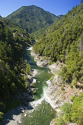
The Salmon River is a 19.6-mile-long (31.5 km) tributary to the Klamath River in western Siskiyou County, California.

The Quinault River is a 69-mile (111 km) long river located on the Olympic Peninsula in the U.S. state of Washington. It originates deep in the Olympic Mountains in the Olympic National Park. It flows southwest through the "Enchanted Valley" to opposite Quinault Canyon. Several miles above Lake Quinault the river is joined by its main tributary, the North Fork Quinault River. The main stem Quinault River above this confluence is sometimes called the East Fork Quinault River. Below the confluence the river marks the boundary of Olympic National Park for several miles before emptying into Lake Quinault. After the lake, the Quinault River flows southwest, reaching the Pacific at Taholah. From Lake Quinault to the ocean, the river is contained within the Quinault Indian Reservation.

Issaquah Creek is a small stream flowing through the city of Issaquah and nearby communities, in the U.S. state of Washington. Its headwaters are on the slopes of Cougar, Squak, Tiger, and Taylor mountains in the Issaquah Alps. Tributaries of Issaquah Creek include Holder Creek, Carey Creek, Fifteen-mile Creek, McDonald Creek, East Fork Issaquah Creek, and North Fork Issaquah Creek. The creek empties into the south end of Lake Sammamish. The lake's outlet is the Sammamish River, which in turn empties into Lake Washington and ultimately Puget Sound.

The Sol Duc River is a river in the U.S. state of Washington. About 78 miles (126 km) long, it flows west through the northwest part of the Olympic Peninsula, from the Olympic Mountains of Olympic National Park and Olympic National Forest, then through the broad Sol Duc Valley. Near the Pacific Ocean the Sol Duc River joins the Bogachiel River, forming the Quillayute River, which flows about 4 miles (6.4 km) to the Pacific Ocean at La Push. Although the Quillayute River is short, its large tributary rivers—the Sol Duc, Bogachiel, Calawah, and Dickey Rivers—drain the largest watershed of the northern Olympic Peninsula, 629 square miles (1,630 km2). The Sol Duc's watershed is the largest of the Quillayute's tributaries, at 219 square miles (570 km2).
The Wallace River is a medium-sized river in Washington, United States. It is a tributary of the Skykomish River and joins near Sultan, just upstream from the mouth of the Sultan River. The Wallace River is 15 miles (24 km) long. Its drainage basin is 30 square miles (78 km2) in area.
The Moclips River is a river in the U.S. state of Washington. It is about 12 miles (19 km) long. Its main tributary, the North Fork Moclips River, is longer than the main stem. The length of the North Fork, along with the lower main stem below the North Fork's confluence, is 17 miles (27 km). The drainage basin of the Moclips River is 22.4 square miles (58 km2) in area.

The Satsop River is a stream in the U.S. state of Washington. It has three main tributary forks, the East Fork, West Fork, and Middle Fork Satsop Rivers. The main stem Satsop River is formed by the confluence of the West and East Forks. The Middle Fork is a tributary of the East Fork. The three forks are much longer than the main stem Satsop itself, which flows south from the confluence only a few miles to join the Chehalis River near Satsop, Washington. Other significant tributaries include the Canyon River and Little River, both tributaries of the West Fork Satsop, and Decker Creek, a tributary of the East Fork Satsop River. The Satsop River's major tributaries originate in the Olympic Mountains and its southern foothills, the Satsop Hills, within Grays Harbor and Mason counties. Most of the Satsop River's watershed consists of heavily wooded hill lands. The upper tributaries extend into Olympic National Forest, approaching but not quite reaching Olympic National Park.

The Beckler River is a tributary of the South Fork Skykomish River in the U.S. state of Washington in the United States.
The Rapid River is a tributary of the Beckler River in the U.S. state of Washington in the United States. It is 13 miles (21 km) long, with a drainage basin of 41 square miles (106 km2).
The Pysht River is a stream in the U.S. state of Washington. It originates near Ellis Mountain in the northern Olympic Mountains on the Olympic Peninsula and flows generally north, emptying into the Strait of Juan de Fuca. The Pysht and nearby Hoko River are the two largest streams flowing into the southwestern portion of the Strait of Juan de Fuca. The watershed of the Pysht River drains a region of industrial forest lands; 98% of the watershed is zoned commercial forestry and the remainder rural. Nearly all of the forests have been logged at least once and most trees are less than thirty years old. The upper portions of the watershed, which feature steep gradients, are owned by the United States Forest Service. The lower reaches, with low gradients, are largely owned by two industrial forest owners.
Sams River is a river in the U.S. state of Washington. A tributary of the Queets River, Sams River flows through Olympic National Park and Olympic National Forest. Part of the river's lower course forms the boundary between the national park and national forest.
The Snahapish River is a river in the U.S. state of Washington. It is a tributary of the Clearwater River, which in turn flows into the Queets River.
The Solleks River is a river in the U.S. state of Washington. It is a tributary of the Clearwater River, which in turn flows into the Queets River.

The South Fork Kings River is a 44.1-mile (71.0 km) tributary of the Kings River in the Sierra Nevada of Fresno County, California. The river forms part of Kings Canyon, the namesake of Kings Canyon National Park and one of the deepest canyons in North America with a maximum relief of 8,200 feet (2,500 m) from rim to river.
The Raft River is a stream located entirely within the Quinault Indian Reservation in Grays Harbor County, on the Olympic Peninsula, in the U.S. state of Washington. The river and its tributaries flow west from the Olympic Mountains and empty into the Pacific Ocean. It is situated a few miles north of the Quinault River and a few miles south of the Queets River.
