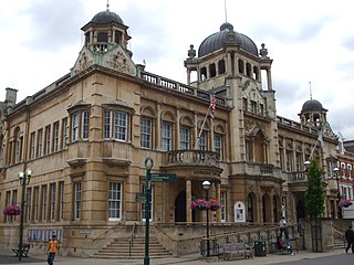
Ilford is a large town in East London, England, 9 miles (14 km) north-east of Charing Cross. Part of the London Borough of Redbridge, Ilford is within the ceremonial county of Greater London. It had a population of 168,168 in 2011, compared to 303,858 for the entire borough.

Becontree or is an area of approximately 4 square miles (10 km2) in the London Borough of Barking and Dagenham. It is located 11 miles (17.7 km) east-northeast of Charing Cross and was constructed in the interwar period as the largest public housing estate in the world. The Housing Act 1919 permitted the London County Council to build housing outside the County of London and Becontree was constructed between 1921 and 1935 to cottage estate principles in the parishes of Barking, Dagenham and Ilford, then in the administrative and ceremonial county of Essex. The official completion of the estate was celebrated in 1935, by which time the estate had a population of around 100,000 people in 26,000 homes.
Goodmayes is a district of Ilford, in East London, England. It is located in the London Borough of Redbridge, eleven miles north-east of Charing Cross, and forms part of both the Romford and Ilford post towns. Historically part of Essex, it was part of the Municipal Borough of Ilford until 1965 when it was incorporated into Greater London.

Harold Wood is a suburban neighbourhood in East London in the London Borough of Havering. It is situated 16.5 miles (26.6 km) east-northeast of Charing Cross. Harold Wood was part of the ancient parish of Hornchurch, which became the Liberty of Havering. Most of the current area of Harold Wood became part of Hornchurch Urban District in 1926. It is near to the Greater London boundary with Essex.

Romford is a large town in East London, England, 14 miles (23 km) northeast of Charing Cross. Part of the London Borough of Havering, the town is one of the major metropolitan centres of Greater London identified in the London Plan.

Upminster is a suburban town in East London, England, within the London Borough of Havering. Located 16.5 miles (26.6 km) east-northeast of Charing Cross, it is one of the locally important district centres identified in the London Plan.

The London Borough of Redbridge is a London borough established in 1965.

The London Borough of Barking and Dagenham is a London borough in East London. It lies around 9 miles (14.4 km) east of Central London. The borough was created in 1965 as the London Borough of Barking; the name was changed in 1980. It is an Outer London borough and the south is within the London Riverside section of the Thames Gateway; an area designated as a national priority for urban regeneration. At the 2011 census it had a population of 187,000. The borough's three main towns are Barking, Chadwell Heath and Dagenham. The local authority is the Barking and Dagenham London Borough Council. Barking and Dagenham was one of six London boroughs to host the 2012 Summer Olympics.
Hainault is a large suburban area in northeast London, England, in the London Borough of Redbridge, 12.5 miles (20.1 km) northeast of Charing Cross. Most of the housing in Hainault was built by the London County Council between 1947 and 1953. Originally spanning the parishes of Chigwell, Dagenham, and Ilford, in 1965 the estate was combined in a single London borough and became part of Greater London.

Manor Park is a residential area of the London Borough of Newham in east London, England. The area is bordered by Ilford to the east, Forest Gate to the west, Wanstead to the north, and East Ham to the south.

Chadwell Heath is an area in East London, England. It is split between the London Borough of Barking and Dagenham and the London Borough of Redbridge, around 2 miles (3.2 km) west of Romford and 4 miles (6.4 km) east of Ilford, and 12 miles (19 km) north-east of Charing Cross.

Little Ilford is a district of London, England in the London Borough of Newham and the name of a ward in that borough.

Barking was a local government district, and later civil parish and borough, in southwest Essex, England from 1882 to 1965. It was known as Barking Town from 1882 to 1931. The district included the town of Barking, eastern Beckton and the southwestern part of the Becontree estate. The district was within the Metropolitan Police District and experienced a steady increase in population during its existence. The area was suburban to London's conurbation region and was part of the Metropolitan Police District. It now forms the western part of the London Borough of Barking and Dagenham and the eastern extremity of the London Borough of Newham in Greater London.
Dagenham was a local government district in south west Essex, England from 1926 to 1965 covering the parish of Dagenham. Initially created as an urban district, it was incorporated as a municipal borough in 1938. It was established to deal with the increase in population and the change from rural to urban area caused by the building of the Becontree estate by the London County Council and the subsequent movement of people from Inner London. Peripheral to London, the district formed part of the Metropolitan Police District and London Traffic Area. It now forms the eastern sections of the London Borough of Barking and Dagenham and the London Borough of Redbridge in Greater London.
Ilford was a civil parish and local government district in south west Essex, England from 1888 to 1965, covering the town Ilford. The district saw a considerable rise in population throughout its life, caused by the expansion of the built-up area of London, and became one of the most populous districts of its type in England. The district now corresponds to the greater part of the London Borough of Redbridge in Greater London.
Barkingside is an area in Ilford, in the London Borough of Redbridge. It includes the major road junction of Fullwell Cross which also gives its name to the locality near that roundabout. The area is situated 10.6 miles (17km) north east of Charing Cross. Prior to 1965, it formed part of the borough of Ilford in the historic county of Essex.
Fairlop is a suburban area of Ilford, in the London Borough of Redbridge in East London. Historically in Essex, it was part of the Municipal Borough of Ilford until 1965, when the rest of Ilford, including Fairlop, became part of Greater London. It lies close to areas such as Loughton, Chigwell, Barkingside and Woodford.
Newbury Park is an area of Ilford in East London situated in the London Borough of Redbridge east of Gants Hill. The main road is the Eastern Avenue (A12), which until the 1920s was a country lane called Hatch Lane. The main landmark in this area is the tube station whose post-war bus shelter received a Festival of Britain award in 1951. The shelter was designed by architect Oliver Hill in 1937.
Redbridge is an area of Ilford in East London, England. It gives its name to the London Borough of Redbridge, a local government district of Greater London, with which it should not be confused.


