Shirlington, Virginia

Last updated
Signature Theatre and Shirlington Library; Shirlington, Arlington, VA; 2014-05-17.jpg
Windsor Apartments; Shirlington, Arlington, VA; 2014-05-17.jpg
Campbell Avenue viewed from South Arlington Mill Drive; Shirlington, Arlington, VA; 2014-05-17.jpg
WETA FM studio and administrative offices; west and south sides; Shirlington, Arlington, VA; 2014-05-17.jpg
Shirlington locations (clockwise from upper left): Signature Theatre and Shirlington Library; Windsor Apartments complex; Campbell Avenue as viewed from South Arlington Mill Drive; and WETA FM's administrative offices.

Shirlington is an unincorporated urban area, officially called an "urban village", [1] in the southern part of Arlington County, Virginia, United States, adjacent to the Fairlington area. The word "Shirlington" is a combination of "Shirley" (from the Shirley Highway or Interstate 395) and "Arlington".

Contents

Shirlington is billed as "Arlington’s Arts and Entertainment District" [2] and is a largely mixed-use development based on New Urbanist principles. It is mostly middle-class residential, but like most of Arlington County has been experiencing an economic renaissance and is now home to many upscale dwellings and retail and service establishments that also serve the nearby Fairlington, Parkfairfax, Green Valley and Long Branch Creek areas.

Geography

Shirlington lies in the valley of Four Mile Run, a tributary of the Potomac River. The land rises toward Fairlington in the south and Green Valley in the north.

The area is bounded by I-395 on the east except for a small section of the Alexandria that lies to the west of the interstate. The only structure in that section, the Shirlington Gateway office building, has an Arlington address and is usually considered a part of Shirlington. To the north and west, starting in the east, Shirlington is bordered by South Glebe Road, 24th Street South, South Shirlington Road, South Four Mile Run Drive, and South Walter Reed Drive. On the west and south, starting in the west, Shirlington is bounded by South Arlington Mill Drive, the Arlington County Environmental Services facility, and the west side of Park Shirlington Apartments.

Most residential, commercial, and retail development lies south of Four Mile Run while the area to the northeast, which is sometimes considered part of neighboring Green Valley, is more light industrial.

History

1988 aerial photo of Shirlington Shirlington USGS.png
1988 aerial photo of Shirlington

Shirlington began when Joseph Cherner, automobile dealer and banker, established the Shirlington Corporation to build a shopping center for nearby Fairlington and Parkfairfax. He began with a 23+12-acre (9.5 ha) site on which the first store opened in June 1944. In 1959, the Lansburgh's department store opened a 150,000-square-foot (14,000 m2), $2.5 million store, its second suburban branch. [3] [4] However, by the 1970s, Shirlington was an aging traditional shopping center facing competition from shopping malls. [5] :1

In the 1980s, Shirlington was partially renovated to create a "traditional main street" along South 28th Street (now Campbell Avenue) with two office buildings at one end and a big box store and a cinema at the other. [5] :1 However, Shirlington remained small.

By 2000, Arlington County authorities, who had previously concentrated on development of areas adjacent to Washington Metro rail lines, began giving more attention to areas not served by Metro, such as the Columbia Pike corridor and Shirlington. [6] The property's owner and the county spurred the creation of a Shirlington Phased Development Site Plan (PDSP) and the associated Shirlington Design Guidelines. [5] :1 A conceptual design for the area was established and almost 1,000,000 square feet (about 93,000 m2) of new mixed-use development was envisioned. [5] :2 Emphasis was placed on making the area pedestrian friendly with automobile parking located behind the commercial buildings. [5] :2 This plan was approved by the Arlington County Board in 2001. [6]

The development, a public-private partnership between developer Federal Realty Investment Trust of Rockville, Maryland (the operator of several other regional town-center-like developments such as Bethesda Row, Pentagon Row, and Rockville Town Center) and the county, began in the mid-2000s. As the plan was implemented, South 28th Street was extended westward and a building to house both the Signature Theatre and the Shirlington Library was constructed. [5] :3 Several new residential and parking structures were added as well. [6]

Economy

Shirlington is home to WETA-TV where nationally-broadcast programs such as PBS Newshour and Washington Week are filmed. [7] WETA-FM radio [7] and some USPTO satellite offices are also located in the town. The non-profit Analytic Services (ANSER) [8] and the Association for Unmanned Vehicle Systems International [9] are headquartered there. The design firm HNTB Corporation has major offices in Shirlington as well.

Transportation

Shirlington Bus Station Shirlington Bus Station; Shirlington, Arlington, VA; 2014-05-17.jpg
Shirlington Bus Station

Shirlington lies on Shirley Highway (I-395) for which the town is named and is accessible from Shirlington Circle (Exit 6 on I-395). The town is served by the Shirlington Bus Station, the only enclosed public bus station in Arlington and the principal transfer point for Metrobus and Arlington Transit (ART) bus service in South Arlington. [10]

Shirlington is the site of the trailhead of the Washington & Old Dominion Railroad Regional Park rail trail that travels along the route of a railroad that closed in 1968, [11] Shirlington Park, [12] and Jennie Dean Park. [13]

Shirlington Circle

Shirlington Circle or Shirlington Rotary ( 38°50′26″N77°5′6″W / 38.84056°N 77.08500°W / 38.84056; -77.08500 ) is a roundabout interchange connecting I-395 (Shirley Highway) with several surface roads in Arlington County and Alexandria. Although the circle is named after Shirlington, roughly half of it is located in Alexandria. The circle resembles roundabout interchanges common in the United Kingdom and Ireland but rare in the US.

The circle includes multiple access points including ramps (slip roads) to and from I-395 (Exit 6) both north and southbound as well as a reversible direction ramp that provides access to and from the reversible high-occupancy vehicle (HOV) lanes that run in the center of I-395. Four surface streets intersect with the circle; going counterclockwise (in the direction of traffic) from the north, they are:

Traffic generally follows roundabout rules, i.e., traffic inside the circle has the right-of-way and traffic entering the circle must yield. However, there are also traffic lights and stop signs regulating traffic flow and the I-395 off-ramps enter the circle from the interior of the circle, requiring a left merge into the traffic circle.

The current circle and traffic arrangement have existed since a 1969-1972 reconstruction of Shirley Highway which widened the previous circle to allow for access to the then-proposed the Four Mile Run Expressway. [14] [15]

A high-occupancy toll lanes (HOT lanes) project proposed for I-395 in the 2000s would have directed additional traffic onto the circle and required the addition of a new entrance and exit to the circle and six new traffic lights, [16] but the Arlington County portion of the project was cancelled in 2011. [17]

Services

Restaurants along Campbell Avenue in 2014 Shirlington, Arlington, Virginia; 2014-05-17.JPG
Restaurants along Campbell Avenue in 2014

Shopping

The center of Shirlington is occupied by the extensive Village at Shirlington retail, service, and residential complex which includes a series of buildings along Campbell Avenue (formerly South 28th Street). It was originally opened in 1944, as Shirlington Shopping Center, one of the earliest suburban shopping centers in the United States, and today provides most of the town's retail shopping. There are numerous restaurants, saloons, a Harris Teeter grocery store, a public library, a full service station that has been there since the 1940s, and a theater in the complex.

Entertainment

Shirlington is home to the Signature Theatre, a Tony-Award-winning regional theater company, Theatre on the Run, and the AMC Loews Shirlington 7 cinema. [5] :4 Public events and festivals include Wags and Whiskers (dog and cat festival) in August, Celtic Festival in September, Oktoberfest in October and Shir-la-la live music and wine tasting on summer Thursdays.

Library

Shirlington has been the site of a public library for over 60 years. The first library was called Fairlington Library after the nearby development of Fairlington which predated Shirlington and was opened in 1947 in the Shirlington Trust Building at 2780 South Randolph Street. The library expanded twice in the 1950s until moving to a location purpose-built for Shirlington Library at 2700 South Arlington Mill Drive in the early 1960s. [18]

Shirlington Library Arlington Virginia 15779238572.jpg

Plans for a new location for the library were approved in late 2000. In 2001, the Arlington Mill Drive location was razed and the Shirlington Library moved to a temporary location in the lower section of the Village at Shirlington shopping center fronting on Arlington Mill Drive (2786 South Arlington Mill Drive). This location housed the library until a flood in the restaurant above it caused the library to close in November 2006. [18] The current Library, a 15,000-square-foot (1,400 m2) facility at 2800 South Stafford Street (since changed to 4200 Campbell Ave) underneath the Signature Theater, which was under construction from August 2005 opened in March 2007. [19] The Shirlington Library is a branch of Arlington Public Library.

See also

Related Research Articles

<span class="mw-page-title-main">Capital Beltway</span> Highway in the Washington metropolitan area

The Capital Beltway is a 64-mile (103 km) auxiliary Interstate Highway in the Washington metropolitan area that surrounds Washington, D.C., the capital of the United States, and its inner suburbs in adjacent Maryland and Virginia. It is the basis of the phrase "inside the Beltway", used when referring to issues dealing with US federal government and politics. The highway is signed as Interstate 495 (I-495) for its entire length, and its southern and eastern half runs concurrently with I-95.

<span class="mw-page-title-main">Interstate 395 (Virginia–District of Columbia)</span> Interstate Highway in the DC area

Interstate 395 (I-395) in Washington, D.C., and Virginia is a 13.79-mile-long (22.19 km) spur route of I-95 that begins at an interchange with I-95 in Springfield and ends at an interchange with US Route 50 (US 50) in Northwest Washington, D.C. It passes underneath the National Mall near the US Capitol and ends at a junction with US 50 at New York Avenue, roughly one mile (1.6 km) north of the 3rd Street Tunnel. Despite its proximity to I-395 in Maryland, the route is unrelated and unconnected.

<span class="mw-page-title-main">Henry G. Shirley Memorial Highway</span>

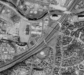
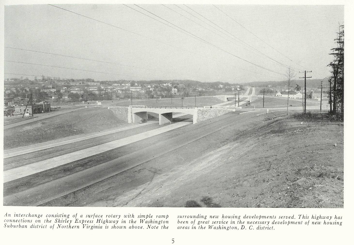
The Henry G. Shirley Memorial Highway, often shortened to Shirley Highway, consists of a 17.3-mile (27.8 km) portion of Interstates 95 and 395 in the U.S. Commonwealth of Virginia. Shirley Highway was the first limited-access freeway in Virginia. Begun in 1941, the road was completed from U.S. Route 1 in Colchester, Virginia, just north of Woodbridge, to the 14th Street Bridge over the Potomac River between Virginia and Washington, D.C. in 1952.

<span class="mw-page-title-main">Virginia State Route 110</span> State highway in Arlington County, Virginia, United States

Virginia State Route 110 (SR 110) is a primary state highway in Arlington, Virginia. Known as the Richmond Highway, the state highway runs 2.41 miles (3.88 km) from U.S. Route 1 (US 1) and Interstate 395 (I-395) in Crystal City north to I-66 in the Rosslyn neighborhood. SR 110 is a four- to six-lane freeway that parallels the Potomac River, providing a connection between several of Arlington's urban villages and major landmarks, including the Pentagon, which is the headquarters of the United States Department of Defense, and the grounds of Arlington National Cemetery. The highway also provides access to SR 27, an east–west freeway between the Pentagon and the cemetery, and the George Washington Parkway that parallels the Potomac River. SR 110 is a part of the National Highway System for its entire length.

<span class="mw-page-title-main">Virginia State Route 244</span>

State Route 244 is a primary state highway in the U.S. state of Virginia. Known as Columbia Pike, the state highway runs 8.25 miles (13.28 km) from SR 236 in Annandale east to SR 27 and Interstate 395 (I-395) at The Pentagon in Arlington. SR 244 is a major southwest–northeast thoroughfare in northeastern Fairfax County and eastern Arlington County, connecting Annandale with SR 7 at Bailey's Crossroads and SR 120 in the multicultural Westmont neighborhood of Arlington.

<span class="mw-page-title-main">Virginia State Route 7</span>

Virginia State Route 7 (VA 7) is a major primary state highway and busy commuter route in northern Virginia, United States. It travels southeast from downtown Winchester to SR 400 in downtown Alexandria. Its route largely parallels those of the Washington & Old Dominion Trail and the Potomac River. Between its western terminus and Interstate 395 (I-395), SR 7 is part of the National Highway System. In 1968, the Virginia State Highway Commission designated the road as the "Harry Flood Byrd Highway" between Alexandria and Winchester to commemorate Harry F. Byrd Sr. (1887–1966).

<span class="mw-page-title-main">Virginia State Route 236</span>

State Route 236 is a primary state highway in the U.S. state of Virginia. The state highway runs 15.63 miles (25.15 km) from U.S. Route 29 and US 50 in Fairfax east to SR 400 in Alexandria. SR 236 is a major suburban arterial highway that connects the independent cities of Fairfax and Alexandria via Annandale in Fairfax County. The state highway is known as Main Street in City of Fairfax, Little River Turnpike in Fairfax County, where the highway meets Interstate 495 (I-495), and Duke Street in Alexandria, where the road has junctions with I-395 and US 1.

<span class="mw-page-title-main">Virginia State Route 120</span>

State Route 120 is a primary state highway in the U.S. state of Virginia. Known as Glebe Road, the state highway runs 9.10 miles (14.65 km) from U.S. Route 1 (US 1) in Crystal City north to SR 123 at the Chain Bridge. SR 120 is a partial circumferential highway in Arlington County that connects the southeastern and northwestern corners of the county with several urban villages along its crescent-shaped path, including Ballston. The state highway also connects all of the major highways in Virginia that radiate from Washington, including Interstate 395, I-66, US 50, and US 29. SR 120 is a part of the National Highway System for its entire length.

<span class="mw-page-title-main">Virginia State Route 27</span> State highway in Arlington County, Virginia, United States

State Route 27 (SR 27) is a freeway in Arlington County, Virginia, in the United States, known as Washington Boulevard. It was built during World War II to connect the Pentagon with U.S. Route 50 (US 50) and northern Arlington to the west and Washington, D.C., to the east. Its 2.54-mile (4.09 km) route parallels the southern boundaries of Arlington National Cemetery. At its southernmost point, Route 27 passes through a complex interchange with Interstate 395. called the "Mixing Bowl," although local motorists more recently use that term also to refer to the Springfield Interchange on the Capital Beltway in Springfield. It is an important commuter route as well as providing access to a number of military installations, the cemetery and national memorials. Because Route 27 is the closest road to the site of the September 11 attack on the Pentagon, the route has been designated the "9/11 Heroes Memorial Highway."

<span class="mw-page-title-main">Fairlington, Virginia</span> United States historic place

Fairlington is an unincorporated neighborhood in Arlington County, Virginia, United States, located adjacent to Shirlington in the southernmost part of the county on the boundary with the City of Alexandria. The main thoroughfares are Interstate 395 which divides the neighborhood into North and South Fairlington, State Route 7 and State Route 402.

<span class="mw-page-title-main">Pentagon road network</span> Highway system in Northern Virginia, US

The Pentagon road network is a system of highways, mostly freeways, built by the United States federal government in the early 1940s to serve the Pentagon in northern Virginia. The roads, transferred to the Commonwealth of Virginia in 1964, are now largely state highways. The main part of the network is the Mixing Bowl at Interstate 395 and Route 27, named because it had major weaving issues with traffic "mixing" between the two roads before it was rebuilt in the early 1970s.

<span class="mw-page-title-main">Virginia State Route 402</span>

State Route 402 is a primary state highway in the U.S. state of Virginia. Known as Quaker Lane, the state highway runs 1.65 miles (2.66 km) from SR 420 north to Interstate 395 at Shirlington Circle within the independent city of Alexandria.

<span class="mw-page-title-main">Virginia State Route 401</span>

State Route 401 is a primary state highway in the U.S. state of Virginia. Known as Van Dorn Street, the state highway runs 2.61 miles (4.20 km) from SR 613 at the south city limit of the independent city of Alexandria north to SR 420 within Alexandria.

<span class="mw-page-title-main">U.S. Route 1 in Virginia</span> Highway in Virginia

U.S. Route 1 (US 1) is a major north–south U.S. Route that serves the East Coast of the United States. In the U.S. state of Virginia, US 1 runs north–south through South Hill, Petersburg, Richmond, Fredericksburg, and Alexandria on its way from North Carolina to the 14th Street bridges into the District of Columbia. It is completely paralleled by Interstate Highways in Virginia—Interstate 85 (I-85) south of Petersburg, I-95 north to Alexandria, and I-395 into the District of Columbia—and now serves mainly local traffic. At its north end, on the approach to the 14th Street bridges, US 1 is concurrent with I-395; the rest of US 1 is on surface roads.

<span class="mw-page-title-main">Arlington Transit</span>

Arlington Transit (ART) is a bus transit system that operates in Arlington County, Virginia, and is managed by the county government. The bus system provides service within Arlington County, and connects to Metrobus, nearby Metrorail stations, Virginia Railway Express, and other local bus systems. Most ART routes serve to connect county neighborhoods to local Metrorail stations, as well as the Shirlington Bus Station. It includes part of the Pike Ride service along Columbia Pike, which is shared with WMATA. In 2022, the system had a ridership of 1,806,500, or about 7,300 per weekday as of the second quarter of 2023.

<span class="mw-page-title-main">Parkfairfax, Virginia</span> United States historic place

Parkfairfax is a neighborhood in Alexandria, Virginia, United States, located in the northwestern part of the city near the boundary with Arlington County. Nearby thoroughfares are Interstate 395, State Route 402, and West Glebe Road.

<span class="mw-page-title-main">Virginia State Route 237</span>

State Route 237 is a primary state highway in the U.S. state of Virginia. The state highway runs 13.07 miles (21.03 km) from SR 236 in Fairfax east to U.S. Route 50 in Arlington. SR 237 connects Fairfax and Arlington with Falls Church. Between Fairfax and Falls Church, the state highway mostly runs concurrently with US 29. East of Falls Church, SR 237 parallels Interstate 66 (I-66) and connects several of Arlington's urban villages.

<span class="mw-page-title-main">Washington Boulevard (Arlington)</span>

Washington Boulevard is a major arterial road in Arlington County, Virginia and Washington, DC. The western portion is designated State Route 237, the eastern portion is State Route 27 and the center is an arterial road with no designation. A short portion of the road enters the District of Columbia on Columbia Island, providing a connection between SR 27 and the Arlington Memorial Bridge.

<span class="mw-page-title-main">The Village at Shirlington</span> Shopping mall in Arlington, Virginia

The Village at Shirlington opened as Shirlington Shopping Center in 1944, and was the first large shopping center to open in the Washington, D.C. suburbs and one of the earliest in the United States. It is located along Campbell Avenue at the intersection of Shirley Highway and Quaker Lane / Shirlington Road in Arlington, Virginia. The center has been known since the mid-1980s as The Village at Shirlington.

<span class="mw-page-title-main">Barcroft–South Fairlington Line</span>

The Barcroft–South Fairlington Line, designated as Route 22A, Route 22C, or Route 22F, is a daily bus route operated by the Washington Metropolitan Area Transit Authority between Ballston–MU station of the Orange and Silver lines of the Washington Metro or Skyline City (22F) and Pentagon station of the Yellow and Blue lines of the Washington Metro. The 22 Line trips are roughly 20 minutes during peak hours, 30 minutes during off peak, and 60 minutes on weekends. This line provides service to Ballston or Skyline City and the Pentagon Transit Center from the neighborhoods of Arlington County, Fairfax County and Alexandria.

References

  1. "Arlington's Urban Villages" at Arlington County webpage. Retrieved 15 April 2011.
  2. "Shirlington" at Arlington Economic Development webpage. Retrieved 15 April 2011.
  3. “Lansburgh Dedicates New Shirlington Store,” by Frank C. Porter, The Washington Post and Times-Herald, Sep 15, 1959, p. B8.
  4. ”Lansburgh's New Store Hailed as County Asset,” by Frank C. Porter, The Washington Post and Times-Herald, Jul 2, 1958, p. D7.
  5. 1 2 3 4 5 6 7 Terry F. Holzheimer. "Creating an Improved Urban Village: The Redevelopment of Shirlington, Virginia." Arlington Economic Development Research Paper. May 2009.
  6. 1 2 3 Daniela Deane."Making Shirlington a Magnet ". Washington Post . 29 January 2005. Page F1. Retrieved 15 April 2011.
  7. 1 2 Map & Directions at WETA website. Retrieved 15 April 2011.
  8. ANSER: Our Locations. Retrieved 15 April 2011.
  9. Association for Unmanned Vehicle Systems International homepage
  10. Shirlington Bus Station webpage at Arlington Transit website. Retrieved 15 April 2011.
  11. History of the Green Valley (formerly known as Nauck) neighborhood in NVRPA's "Nauck: A Neighborhood History" marker at trailhead of W&OD Trail in Shirlington in Arlington County, Virginia, in "Washington and Old Dominion Railroad Markers" series in HMdb.org: The Historical Marker Database official website Retrieved 15 April 2011.
  12. Shirlington Park webpage at the Arlington County Government official website. Retrieved 15 April 2011.
  13. Jennie Dean Park webpage at the Arlington County Government official website Retrieved 15 April 2011.
  14. Scott M. Kozel. "Henry G. Shirley Memorial Highway". Roads to the Future website. Retrieved 20 January 2011.
  15. Scott M. Kozel. "The 1969 Northern Virginia Major Thoroughfare Plan". Roads to the Future website. Retrieved 20 January 2011.
  16. "Virginia scales back plans for HOT lanes". WTOP-FM website. 18 August 2009. Retrieved 20 January 2011.
  17. Christy Goodman. "New HOT lane plan for Virginia's I-95 corridor". Washington Post. 3 February 2011. Retrieved 20 August 2015.
  18. 1 2 "About Shirlington Branch Library". Shirlington Branch Library webpage. Retrieved 15 April 2011.
  19. "Shirlington Library Welcomes Community to Grand Opening Festivities". Arlington County Press Release. 12 March 2007. Retrieved 15 April 2011.

38°50′30″N77°05′18″W / 38.84167°N 77.08833°W / 38.84167; -77.08833