South Fork Coos River

Last updated
South Fork Coos River
Name origin: Indian name for a native tribe living near Coos Bay [1]
Country United States
State Oregon
County Coos
Sourceconfluence of the Williams River with Tioga Creek
 - locationeastern Coos County, Southern Oregon Coast Range
 - elevation507 ft (155 m) [2]
 - coordinates 43°19′04″N123°48′32″W / 43.31778°N 123.80889°W / 43.31778; -123.80889   [3]
Mouth Coos River
 - locationdownstream of Dellwood
 - elevation13 ft (4 m) [3]
 - coordinates 43°22′39″N124°05′57″W / 43.37750°N 124.09917°W / 43.37750; -124.09917 Coordinates: 43°22′39″N124°05′57″W / 43.37750°N 124.09917°W / 43.37750; -124.09917   [3]
Length32 mi (51 km) [4]
USA Oregon location map.svg
Red pog.svg
Location of the mouth of the South Fork Coos River in Oregon

The South Fork Coos River is a tributary, about 32 miles (51 km) long, of the Coos River in the U.S. state of Oregon. Formed by the confluence of the Williams River and Tioga Creek, it begins in eastern Coos County near the Douglas County line and flows generally northwest through the Southern Oregon Coast Range. East of the city of Coos Bay, it joins the Millicoma River to form the Coos River. This larger river, only about 5 miles (8 km) long, empties into the eastern end of Coos Bay, which connects to the Pacific Ocean. [4]

Coos River Gold

The Coos River flows for about 5 miles (8.0 km) into Coos Bay along the Pacific coast of southwest Oregon in the United States. Formed by the confluence of its major tributaries, the South Fork Coos River and the Millicoma River, it drains an important timber-producing region of the Southern Oregon Coast Range. The course of the main stem and the major tributaries is generally westward from the coastal forests to the eastern end of Coos Bay near the city of Coos Bay.

U.S. state constituent political entity sharing sovereignty as the United States of America

In the United States, a state is a constituent political entity, of which there are currently 50. Bound together in a political union, each state holds governmental jurisdiction over a separate and defined geographic territory and shares its sovereignty with the federal government. Due to this shared sovereignty, Americans are citizens both of the federal republic and of the state in which they reside. State citizenship and residency are flexible, and no government approval is required to move between states, except for persons restricted by certain types of court orders. Four states use the term commonwealth rather than state in their full official names.

Oregon State of the United States of America

Oregon is a state in the Pacific Northwest region on the West Coast of the United States. The Columbia River delineates much of Oregon's northern boundary with Washington, while the Snake River delineates much of its eastern boundary with Idaho. The parallel 42° north delineates the southern boundary with California and Nevada. Oregon is one of only three states of the contiguous United States to have a coastline on the Pacific Ocean.

Contents

Course

From its source, the river flows north through forests, receiving Mink Creek from the left. About 3 miles (5 km) further downstream, the river turns west, and Fall Creek enters from the right. Over the next stretch, Coal and Fannin creeks enter from the left and Elk Creek from the right. The river then turns south before Rock Crusher and Burma creeks enter from the left at about river mile (RM) 20 or river kilometer (RK) 32. Turning west, the river receives Cox Creek from the left. [4] [5]

River mile

In the United States, a river mile is a measure of distance in miles along a river from its mouth. River mile numbers begin at zero and increase further upstream. The corresponding metric unit using kilometers is the river kilometer. They are analogous to vehicle roadway mile markers, except that river miles are rarely marked on the physical river; instead they are marked on navigation charts, and topographic maps. Riverfront properties are sometimes partially legally described by their river mile.

After the river turns north again, it receives Big Creek from the right then meanders west, receiving East and West creeks from the right and Salmon Creek from the left at about RM 9 (RK 14). Over the next stretch, McKnight Creek enters from the right before the river reaches the community of Dellwood, which is on the right. Bessey Creek enters from the right and then Rogers Creek from the right about 4 miles (6 km) from the mouth. Morgan Creek enters from the left before the West Fork Coos River passes under Landrith Bridge and South Coos River Lane and meets the Millicoma River. South Coos River Lane runs along the stream to the vicinity of Dellwood, and the rest of the river is accessible by logging roads. [4] [5]

Dellwood, Oregon Unincorporated community in Oregon, United States

Dellwood is an unincorporated community in Coos County, Oregon, United States. It is about 12 miles (19 km) east of Coos Bay, east of Oregon Route 241 on the South Fork Coos River.

River delta Silt deposition landform at the mouth of a river

A river delta is a landform that forms from deposition of sediment that is carried by a river as the flow leaves its mouth and enters slower-moving or stagnant water. This occurs where a river enters an ocean, sea, estuary, lake, reservoir, or another river that cannot carry away the supplied sediment. The size and shape of a delta is controlled by the balance between watershed processes that supply sediment, and receiving basin processes that redistribute, sequester, and export that sediment. The size, geometry, and location of the receiving basin also plays an important role in delta evolution. River deltas are important in human civilization, as they are major agricultural production centers and population centers. They can provide coastline defense and can impact drinking water supply. They are also ecologically important, with different species' assemblages depending on their landscape position.

Recreation

The river supports populations of shad, chinook and coho salmon, steelhead, and coastal cutthroat trout. The Oregon Department of Fish and Wildlife operates a steelhead hatchery near Dellwood. Above Dellwood, the stream is accessible by roads on land owned by Weyerhauser, a timber company, and parking or fishing along the upper river requires a Weyerhouser permit. Below the head of tide at Dellwood, it is possible to fish from the bank near the mouth of Daniels Creek, and boaters can fish the entire lower river. [6]

Chinook salmon species of fish

The Chinook salmon is the largest species in the Pacific salmon genus Oncorhynchus. The common name refers to the Chinookan peoples. Other vernacular names for the species include king salmon, Quinnat salmon, spring salmon, chrome hog, and Tyee salmon. The scientific species name is based on the Russian common name chavycha (чавыча).

Coho salmon species of fish

The coho salmon is a species of anadromous fish in the salmon family, one of the several species of Pacific salmon. Coho salmon are also known as silver salmon or "silvers". The scientific species name is based on the Russian common name kizhuch (кижуч).

Rainbow trout species of trout

The rainbow trout is a trout and species of salmonid native to cold-water tributaries of the Pacific Ocean in Asia and North America. The steelhead is an anadromous (sea-run) form of the coastal rainbow trout(O. m. irideus) or Columbia River redband trout (O. m. gairdneri) that usually returns to fresh water to spawn after living two to three years in the ocean. Freshwater forms that have been introduced into the Great Lakes and migrate into tributaries to spawn are also called steelhead.

Whitewater boaters sometimes run a 6.1-mile (9.8 km) stretch of the river beginning about 12 miles (19 km) upstream of Dellwood. Weyerhauser, which owns the land through which this part of the river flows, restricts boating access to weekends only. [7]

Whitewater bubbly, or aerated and unstable current

Whitewater is formed in a rapid, when a river's gradient increases enough to generate so much turbulence that air is entrained into the water body, that is, it forms a bubbly or aerated and unstable current; the frothy water appears white. The term is also loosely used to refer to less turbulent, but still agitated, flows.

See also

Related Research Articles

Siletz River river in the United States of America

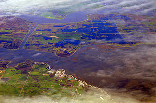
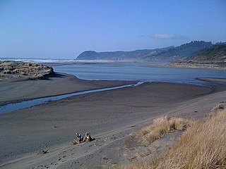
The Siletz River flows about 67 miles (108 km) to the Pacific Ocean through coastal mountains in the U.S. state of Oregon. Formed by the confluence of its north and south forks near Valsetz in Polk County, it winds through the Central Oregon Coast Range. The river, draining a watershed of 373 square miles (970 km2), empties into Siletz Bay, south of Lincoln City in Lincoln County. Although the river travels 67 miles (108 km) in river miles, its winding course begins only about 20 miles (32 km) east of the ocean, and its mouth and source latitudes are almost identical.

Elk River (Oregon) river in southwestern Oregon in the United States

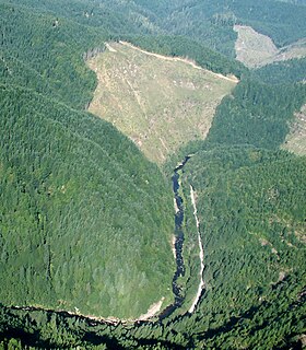
The Elk River is in southwestern Oregon in the United States. About 29 miles (47 km) long, the river drains a remote 92-square-mile (240 km2) area of the Coast Range into the Pacific Ocean.

Trask River river in Oregon

The Trask River is in northwestern Oregon in the United States. It drains a mountainous timber-producing area of the Northern Oregon Coast Range west of Portland into Tillamook Bay and the Pacific Ocean. It is one of five rivers—the Tillamook, the Trask, the Wilson, the Kilchis, and the Miami—that flow into the bay.

Kilchis River river in the United States of America

The Kilchis River is a stream, about 14 miles (23 km) long, near the coast of northwest Oregon in the United States. It drains a mountainous timbered region of about 65 square miles (170 km2) in the Northern Oregon Coast Range west of Portland.

Collawash River river in the United States of America

The Collawash River is a 12-mile (19 km) tributary of the Clackamas River in the U.S. state of Oregon. Formed by the confluence of Elk Lake Creek and the East Fork Collawash River in the Cascade Range, it flows generally north-northwest from source to mouth through the Mount Hood National Forest. The largest tributary of the upper Clackamas, it provides about a third of bigger river's low-flow volume. About 35 percent of its watershed of 150 square miles (390 km2) is protected as wilderness.

Umatilla River tributary of the Columbia River in Oregon

The Umatilla River is an 89-mile (143 km) tributary of the Columbia River in the U.S. state of Oregon. Draining a basin of 2,450 square miles (6,300 km2), it enters the Columbia near the city of Umatilla in the northeastern part of the state. In downstream order, beginning at the headwaters, major tributaries of the Umatilla River are the North Fork Umatilla River and the South Fork Umatilla River, then Meacham, McKay, Birch, and Butter creeks.

South Fork Rogue River tributary of the Rogue River in Oregon

The South Fork Rogue River is a 25-mile (40 km) tributary of the Rogue River in the U.S. state of Oregon. Rising in the Sky Lakes Wilderness in the Cascade Range, it flows generally northeast through the Rogue River – Siskiyou National Forest to meet the Rogue River downstream of Prospect and slightly upstream of Lost Creek Lake.

Pistol River river in the United States of America

The Pistol River is a coastal stream that meanders for 21 miles (34 km) through the Southern Oregon Coast Range to the Pacific Ocean near the unincorporated community of Pistol River in the U.S. state of Oregon. Flowing generally southwest from its origin near Sugarloaf Mountain in the Siskiyou National Forest, the river enters the sea at Pistol River State Scenic Viewpoint, 10 miles (16 km) south of Gold Beach. The river received its name after pioneer James Mace lost his pistol in it in 1853.

Millicoma River river in the United States of America

The Millicoma River is a coast stream, about 8.5 miles (13.7 km) long, east of Coos Bay in the U.S. state of Oregon. Formed by the confluence of the East Fork Millicoma River and the West Fork Millicoma River at Allegany, it meanders across relatively flat land to meet the South Fork Coos River, with which it forms the Coos River.

East Fork Millicoma River river in the United States of America

The East Fork Millicoma River is a tributary, about 24 miles (39 km) long, of the Millicoma River in the U.S. state of Oregon. Rising in eastern Coos County, it flows generally west to the community of Allegany, where it joins the West Fork Millicoma River to form the Millicoma. In turn, the Millicoma, which is only about 9 miles (14 km) long, joins the South Fork Coos River to form the Coos River. The Coos River, itself only about 5 miles (8 km) long, empties into the eastern end of Coos Bay, which connects to the Pacific Ocean.

West Fork Millicoma River river in the United States of America

The West Fork Millicoma River is a tributary, about 34 miles (55 km) long, of the Millicoma River in the U.S. state of Oregon. Rising in northeastern Coos County near the Douglas County line, it flows generally southwest through the Elliott State Forest of the Southern Oregon Coast Range to the community of Allegany. There it joins the East Fork Millicoma River to form the Millicoma. In turn, the Millicoma, which is only about 9 miles (14 km) long, joins the South Fork Coos River to form the Coos River. The Coos River, itself only about 5 miles (8 km) long, empties into the eastern end of Coos Bay, which connects to the Pacific Ocean.

Williams River (Oregon) river in the United States of America

The Williams River is a tributary, about 21 miles (34 km) long, of the South Fork Coos River in the U.S. state of Oregon. Formed by the confluence of Lost Creek and Little Cow Creek, it begins in western Douglas County near the Coos County line and flows generally northwest through the Southern Oregon Coast Range. In eastern Coos County, it joins Tioga Creek to form the South Fork Coos River about 32 miles (51 km) from its confluence with the Millicoma River.

Little Luckiamute River river in the United States of America

The Little Luckiamute River is a stream in Polk County in the U.S. state of Oregon. It rises in the Central Oregon Coast Range near Fanno Peak and joins the Luckiamute River about 4 miles (6 km) upstream of the Sarah Helmick State Recreation Site southwest of Monmouth.

South Fork McKenzie River tributary of the McKenzie River in Oregon

The South Fork McKenzie River is a tributary, about 31 miles (50 km) long, of the McKenzie River in the U.S. state of Oregon. It begins at about 4,500 feet (1,400 m) above sea level near Mink Lake in the Three Sisters Wilderness of the Cascade Range. Flowing northwest within Lane County, it meets the McKenzie River about 60 miles (97 km) from the larger river's confluence with the Willamette River.

North Fork Alsea River river in the United States of America

The North Fork Alsea River is a 16-mile (26 km) tributary of the Alsea River in the U.S. state of Oregon. It begins at Klickitat Lake, fed by Klickitat and Lake creeks in the Central Oregon Coast Range, and flows generally south to near Alsea, where it joins the South Fork Alsea River to form the main stem. For most of its course, the North Fork winds through the Siuslaw National Forest in Lincoln County and then Benton County. It passes under Oregon Route 34 northeast of Alsea.

North Fork Siuslaw River river in the United States of America

The North Fork Siuslaw River is a tributary of the Siuslaw River in Lane County in the United States state of Oregon. It is formed by the confluence of Sam Creek and West Branch in the Siuslaw National Forest of the Central Oregon Coast Range. The former community of Pawn was once at the juncture of the two creeks. From here, the river flows about 2 miles (3 km) southeast, then about 25 miles (40 km) southwest to meet the main stem 1.2 miles (1.9 km) east of Florence.

Crabtree Creek (South Santiam River tributary)

Crabtree Creek is a tributary of the South Santiam River in Linn County in the U.S. state of Oregon. It begins in the western foothills of the Cascade Range at Crabtree Mountain near Crabtree Lake. From there it flows generally west to meet the larger stream about 3 miles (5 km) upstream of where the South Santiam merges with the North Santiam River to form the Santiam River.

Middle Fork Coquille River river in the United States of America

The Middle Fork Coquille River is a tributary, about 40 miles (64 km) long, of the South Fork Coquille River in the U.S. state of Oregon. It begins near Camas Mountain in Douglas County in the Southern Oregon Coast Range. It flows generally south, bypassing the community of Camas Valley while passing through the valley of the same name, then curves west and north to Remote in Coos County. The Middle Fork then flows generally west, passes by the small community of Bridge, and meets the South Fork near Myrtle Point. The confluence with the South Fork is 41 miles (66 km) by water to where the main stem of the Coquille River enters the Pacific Ocean at Bandon.

East Fork Coquille River river in the United States of America

The East Fork Coquille River is a tributary, about 34 miles (55 km) long, of the North Fork Coquille River in the U.S. state of Oregon. It begins near Bennett Rock in Douglas County in the Southern Oregon Coast Range.

References

  1. McArthur, p. 228
  2. Source elevation derived from Google Earth search using GNIS source coordinates.
  3. 1 2 3 "South Fork Coos River". Geographic Names Information System. United States Geological Survey. November 28, 1980. Retrieved April 4, 2011.
  4. 1 2 3 4 United States Geological Survey. "United States Geological Survey Topographic Map". TopoQuest. Retrieved April 4, 2011. The maps include river mile (RM) markers for the entire length of the river. The markers begin at the mouth of the Coos River, and the South Fork begins between markers 5 and 6. Relevant map quadrangles from mouth to source are Allegany, Daniels Creek, Coos Mountain, Golden Falls, and Tioga.
  5. 1 2 Oregon Atlas and Gazetteer (Map) (1991 ed.). DeLorme Mapping. § 3334. ISBN   978-0-89933-347-2.
  6. Sheehan, p. 67
  7. Giordano, pp. 7071

Works cited

International Standard Book Number Unique numeric book identifier

The International Standard Book Number (ISBN) is a numeric commercial book identifier which is intended to be unique. Publishers purchase ISBNs from an affiliate of the International ISBN Agency.