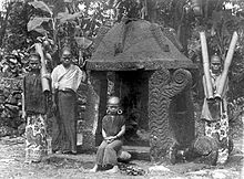
Nias is an island located off the western coast of Sumatra, Indonesia. Nias is also the name of the archipelago of which the island is the centre, but also includes the Batu Islands to the south-east and the small Hinako Islands to the west. Nias Island covers an area of 5,573.27 km2 (2,151.85 sq mi). It is mostly a lowland area rising to around 800 m (2,600 ft) above sea level. There were 756,338 inhabitants on the island at the 2010 Census; at the 2015 Intermediate Census this had risen to 798,506 and the 2020 Census resulted in a total of 880,550. The official estimate as at mid 2023 was 930,294.

The Lingga Regency is a group of islands in Indonesia, located south of Singapore, along both sides of the equator, off the eastern coast of Riau Province on Sumatra island. They are south of the populated Riau Archipelago, known for the industrial island of Batam and the tourist-frequented island of Bintan, although the Lingga Islands themselves are rarely visited due to the infrequent local transportation. The equator goes through the northern tip of Lingga Island, the main island in the archipelago.

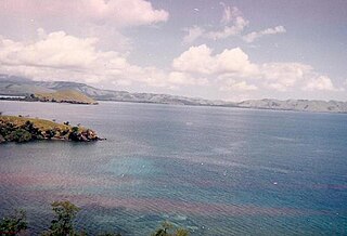
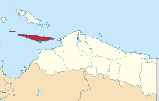
The Batu Islands are an archipelago of Indonesia located in the Indian Ocean, off the west coast of Sumatra, between Nias and Siberut. The three primary islands, of approximately equal size, are Pini, Tanahmasa, and Tanahbala. There are seventy-five smaller islands, of which the largest are Sipika, Tello and Sigata, Simuk and Bojo ; less than half are inhabited. The total land area of the seven administrative districts is 1,201.1 km2. The islands are governed as a part of South Nias regency within North Sumatra province. In Indonesian and Malay, batu means rock or stone.
Sikka is a regency within East Nusa Tenggara province, Indonesia, on the island of Flores. It is bordered to the west by Ende Regency and to the east by East Flores Regency. It covers an area of 1,731.91 km2 and had a population of 300,301 at the 2010 census and 321,953 at the 2020 Census; the official estimate as at mid 2022 was 326,999. The capital is the town of Maumere, which comprises the districts of Alok Barat, Alok and Alok Timur.

Nunukan Regency is a regency of North Kalimantan Province in Indonesia. It was created on 4 October 1999 from the northern districts of Bulungan Regency. Nunukan Regency shares international borders with the Malaysian states of Sabah to the north and Sarawak to the west, and inter-regency borders with Tana Tidung Regency and Malinau Regency to the south, as well as the coastal city of Tarakan in the east. The regency covers an area of 14,247.50 km2 and it had a population of 140,841 at the 2010 census and 199,090 at the 2020 census; the official estimate as at mid 2022 was 208,303.

North Bengkulu is a regency of Bengkulu Province, Indonesia, on the island of Sumatra. It originally covered much of the northern part of Bengkulu Province, but on 25 February 2003 the most northwesterly districts were split off to form a separate Mukomuko Regency, and on 24 June 2008 the most southeastern districts were likewise split off to create a new Central Bengkulu Regency. The residual regency now covers an area of 4,424.59 km2, and it had a population of 257,675 at the 2010 Census and 296,523 at the 2020 Census; the official estimate as at mid 2022 was 302,833. The administrative centre is at the town of Arga Makmur.
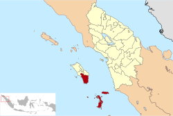
The Selayar Islands Regency is a regency of Indonesia in South Sulawesi province that covers the Selayar Islands, which lie southeast of the southern peninsula of Sulawesi. The archipelago consists of the group's main island, which is surrounded by 41 smaller islands around its coast; further to the southeast lies a widespread group of islands, including the huge atoll of Takabonerate. The regency covers an area of 1,357.03 km2, and had a population of 103,596 at the 2000 Census, 122,055 at the Census of 2010 and 137,071 at that of 2020. The official estimate for mid 2022 was 139,145. The administrative centre is the town of Benteng on Selayar Island. The Selayar Straits separate the regency from Sulawesi island.

The Karimun Regency is located in the Riau Islands Province, Indonesia. Besides the central island of Great Karimun, the regency also includes the islands of Kundur and over 240 smaller islands. The district covers a land area of 1,524 km2 and a sea area of 6,460 km2, and its population was 212,561 at the 2010 census and 253,457 at the 2020 census; the official estimate as at mid 2022 was 266,177.

Nias Regency is a regency in North Sumatra province, Indonesia; it lies on the east side of Nias Island. The regency originally covered the entire island, but was reduced to the northern half, with an area of 3,495.39 square kilometres, following the creation of the new regency of Nias Selatan on 25 February 2003. It was further reduced by the creation of the new regencies of Nias Utara and Nias Barat and the independent municipality of Gunungsitoli from other parts of Nias Regency on 29 October 2008. Since the separation of the new regencies and municipality, the reduced Regency now covers 853.44 km2 of land in the eastern part of the island, and had a population of 131,377 at the 2010 Census and 146,672 at the 2020 Census; the official estimate as at mid 2023 was 153,658. Its seat is the town of Gido.

North Padang Lawas is a regency in North Sumatra province of Indonesia. It has an area of 3,918.05 km2, and had a population of 223,049 at the 2010 census and 260,720 at the 2020 census; the official estimate as at mid 2022 was 267,275. North Padang Lawas Regency was created on 17 July 2007 from eastern parts of the South Tapanuli Regency. Its administrative seat is the town of Gunung Tua.

West Bangka Regency is a regency (kabupaten) of Bangka Belitung Islands Province, Indonesia. It comprises the northwestern part of Bangka Island, together with a number of small islands off its coast. The regency covers an area of 2,820.61 km2 and had a population of 175,110 at the 2010 Census, rising to 204,612 at the 2020 census; the official estimate as at mid 2022 was 209,791 - comprising 108,102 males and 101,689 females. The town of Muntok is its regency seat.
Yapen Islands Regency is a regency (kabupaten) in Papua Province of eastern Indonesia. It covers an area of 2,432.49 km2 (939.19 sq mi), and had a population of 82,951 at the 2010 Census and 112,676 at the 2020 Census; the official estimate as at mid 2022 was 116,107. It comprises an archipelago which lies in Cenderawasih Bay off the north coast of Western New Guinea.

West Sumbawa Regency is a Regency (Kabupaten) of the Indonesian Province of West Nusa Tenggara. It is located on the island of Sumbawa and has an area of 1,743.58 km2. The regency was created on 18 December 2003 from what were at that time the westernmost five districts (kecamatan) of Sumbawa Regency. The population at the 2010 Census was 114,754, and at the 2020 Census was 145,798; the official estimate as at mid 2022 was 151,775 - comprising 76,959 males and 74,816 females. The capital is the town of Taliwang.

Manggarai Regency is a regency in East Nusa Tenggara province of Indonesia, situated on the island of Flores. Established in 1958 the regency was reduced in size and population by the separation of West Manggarai Regency in 2003 and of East Manggarai Regency in 2007. The area of the residual Manggarai Regency is 1,344.03 km2 and its population was 292,037 at the 2010 census and 312,855 at the 2020 census; the official estimate as at mid 2022 was 317,646. The capital of the regency is the town of Ruteng.

North Barito Regency is one of the thirteen regencies which divide the Central Kalimantan Province on the island of Kalimantan, Indonesia. It originally included much more of the northern part of the province, but on 10 April 2002 the larger northwestern part of the regency was split off to create a new Murung Raya Regency. Muara Teweh is the capital of North Barito Regency, which covers an area of 10,152.25 km2. The population of North Barito Regency was 121,573 at the 2010 Census and 154,812 at the 2020 Census; the official estimate as at mid 2022 was 160,235.
Pringsewu Regency is a regency of Lampung Province, Sumatra, Indonesia. It has an area of 625 km² and had a population of 364,825 people at the 2010 Census and 405,466 at the 2020 Census; the official estimate as at mid 2022 was 408,415. The regency seat is the town of Pringsewu, located 37 kilometres from the provincial capital of Bandar Lampung. The regency was created on 29 October 2008 from the former eastern part of Tanggamus Regency.

Tanggamus Regency is a regency (kabupaten) of Lampung Province, Sumatra, Indonesia. It has an area of 4,654.96 km² and had a population of 534,595 at the 2010 Census and 640,275 at the 2020 Census; the official estimate as at mid 2022 was 652,898. The regency seat is the town of Kota Agung Pusat. The regency was created on 21 March 1997, but districts in its eastern part were split away on 29 October 2008 to form a new Pringsewu Regency. It lies in the southwest of the province, and surrounds Semangka Bay on its west, north and east coasts.

South Konawe Regency is a regency of Southeast Sulawesi Province, Indonesia. It covers an area of 4,237.74 km2 and had a population of 264,587 at the 2010 Census and of 308,524 at the 2020 Census; the official estimate as at mid 2022 was 317,826 - comprising 162,949 males and 154,877 females. The administrative centre is in the town of Andoolo.

Maybrat Regency is a regency of Southwest Papua Province of Indonesia. It has an area of 5,461.69 km2 (2,108.77 sq mi), and had a population of 33,081 at the 2010 Census and 42,991 at the 2020 Census; the official estimate as at mid 2022 was 44,812. The administrative centre is the town of Kumurkek, in Aifat Dstrict. The Maybrat language is spoken in the regency.

Pesisir Barat Regency is a regency in Lampung Province of Indonesia. It was created on 25 October 2012 from the eight western districts of West Lampung Regency. It covers an area of 2,907.23 km2, and had a population of 141,741 at the 2010 Census and 162,697 at the 2020 Census; the official estimate as of mid-2022 was 164,816. The administrative center is the town of Krui. The majority group in the Pesisir Barat Regency is the Lampung people.