SoMa is home to many of the city's museums, to the headquarters of several major software and Internet companies, and to the Moscone Conference Center.
As with many neighborhoods, the precise boundaries of the South of Market area are fuzzy and can vary widely depending on the authority cited. From 1848 until the construction of the Central Freeway in the 1950s, 9th Street (formerly known as Johnston Street) was the official (and generally recognized) boundary between SoMa and the Mission District.[6][7] Since the 1950s, the boundary has been either 10th Street, 11th Street,[8] or the Central Freeway. Similarly, the entire Mission Bay neighborhood may or may not be counted as part of SoMa,[9] Excluding the entire Mission Bay neighborhood puts the southeastern boundary at Townsend. Redevelopment agencies, social service agencies, and community activists frequently exclude the more prosperous areas between the waterfront and 3rd Street. Some social service agencies and nonprofits count the economically distressed area around 6th, 7th, and 8th streets as part of the Mid-Market Corridor. [citation needed]
The terms "South of Market" and "SoMa" refer to both a comparatively large district of the city[10] as well as a much smaller neighborhood.[11]
While many San Franciscans refer to the neighborhood by its full name, South of Market, there is a trend to shorten the name to SOMA or SoMa, probably[citation needed] in reference to SoHo (South of Houston) in New York City, and, in turn, Soho in London.
Before being called South of Market this area was called "South of the Slot", a reference to the cable cars that ran up and down Market along the slots through which they gripped cables. While the cable cars have long since disappeared from Market Street, some "old timers" still refer to this area as "South of the Slot".[8]
Since 1847 [citation needed], the official name of the South of Market area has been the "100 Vara Survey" (alternately "100 Vara District") or simply "100 Vara" for short (with "100" sometimes spelled out). The "100 Vara Survey" derived its name from the surface area of the single lots which comprised 100 by 100 varas (275 square feet).[12]
According to city documents from 1945,[13] the "100 Vara District" goes from the south side of Market Street to the Ferry. The name is found mainly in history books, legal documents,[14] title deeds, and civil engineering reports.[15]
History
In 1847 Washington A. Bartlett, alcalde (magistrate) of the pueblo (village) of San Francisco, commissioned surveyor Jasper O'Farrell to extend the boundaries of the pueblo in a southerly direction by creating a new subdivision. At the time, the streets of San Francisco were aligned approximately with the compass points, running north to south, or east to west. Each block was divided into six lots 50 varas on a side. (A vara is about 33 inches (84cm).) O'Farrell decided that the streets in the new subdivision should run parallel with or perpendicular to the only existing road in the area, Mission Road (later Mission Street), and thus be aligned with the half-points of the compass, i.e., northeast to southwest, and northwest to southeast. He also decided to make the new blocks twice as long and twice as wide, with each lot 100 varas on a side. Finally, O'Farrell created "a grand promenade" linking the old pueblo with the new subdivision, Market Street.[16] Since then, downtown San Francisco north of Lower Market Street has been officially known as 50 Vara, while the South of Market area is officially known as 100 Vara.[13]
During the mid-19th century, SOMA became a burgeoning pioneer community, consisting largely of low-density residential buildings, except for a business district that developed along 2nd and 3rd streets, and emerging industrial areas near the waterfront. Rincon Hill became an enclave for the wealthy, while nearby South Park became an enclave for the upper middle class.[17] By the early 20th century, heavy industrial development due to its proximity to the docks of San Francisco Bay, coupled with the advent of cable cars, had driven the wealthy over to Nob Hill and points west. The neighborhood became a largely working-class and lower-middle-class community of recent European immigrants, sweatshops, power stations, flophouses, and factories.[citation needed]
The 1906 earthquake completely destroyed the area, and many of the quake's fatalities occurred there. Following the quake, the area was rebuilt with wider than usual streets, as the focus was on the development of light to heavy industry. The construction of the Bay Bridge and U.S. Route 101 during the 1930s saw large swaths of the area demolished, including most of the original Rincon Hill.[18]
From the late 19th century to the mid-20th century, the South of Market area was served by several streetcar lines owned by the Market Street Railway Company, including the No. 14 Mission Street electric railway line, the No. 27 Bryant Street line, the 28 Harrison, 35 Howard, 36 Folsom, 41 Second and Market, and the No. 42 First and Fifth Street line.[19]
Throughout the 1940s and 1950s, South of Market was home not only to warehousing and light industry, but also to a sizable population of transients, seamen, other working men living in hotels, and a working-class residential population in old Victorian buildings on smaller side streets and alleyways giving it a "skid row" reputation.[20]
"South of Market in the land of ruin You get all manner of action Tinsel tigers in The Metal Room Stalking satisfaction. They got 'em packaged up for love and money Tattooed tots and chrome spike bunnies Check my conscience at the DMZ And roll on in, gonna roll in it, honey But I get a feelin like when big things collide Like the crack before the thunder, like I really ought to hide And here comes Metal Angel, she looks ready to ride; & What's that she's tryin' to show me..? What's that you're tryin' to show me..?"
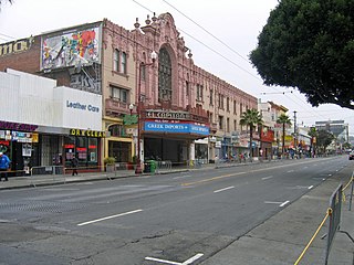
The waterfront redevelopment of the Embarcadero in the 1950s pushed a new population into this area in the 1960s, the incipient gay community, and the leather community in particular. From 1962 until 1982, the gay leather community grew and thrived throughout South of Market, most visibly along Folsom Street, since it was a warehouse area that was largely deserted at night.[22] Site of various sex clubs and bars, such as the Caldron and the Slot, it was the sexual center of San Francisco during this period.[23][24] This community had been active in resisting the city's ambitious redevelopment program for the area throughout the 1970s. But as the AIDS epidemic unfolded in the 1980s, the ability of this community to stand up to downtown and City Hall was dramatically weakened. The crisis became an opportunity for the city (in the name of public health) to close bathhouses and regulate bars - businesses that had been the cornerstone of the community's efforts to maintain a gay space in the South of Market neighborhood.[20]
In 1984, as these spaces for the gay community were rapidly closing, a coalition of housing activists and community organizers started the Folsom Street Fair, in order to enhance the visibility of the community at a time when people in City Hall and elsewhere were apt to think it had gone away. The fair also provided a means for much-needed fundraising, and created opportunities for members of the leather community to connect to services and vital information (e.g., regarding safer sex) which bathhouses and bars might otherwise have been ideally situated to distribute.[20]
Redevelopment plans were first outlined in 1953. These plans began to be realized in the late 1970s and in the early 1980s with the construction of the conference center, Moscone Center, which occupies three blocks and hosts many major trade shows. Moscone South opened its doors in December 1981. Moscone North opened in May 1992, and most recently Moscone West in June 2003.
With the opening of the San Francisco Museum of Modern Art in 1995, the Mission and Howard Street area of the South of Market has become a hub for museums and performances spaces. Intersection for the Arts is also based in the neighborhood, a non-profit which supports local Bay Area artists. The San Francisco institution was founded in 1965 in the Tenderloin, but has moved within the city to its current location in SoMa. Intersection supports the arts by offering local artists resources, fiscal sponsorship, and exhibition and performance spaces.
The area has long been home to bars and nightclubs. During the 1980s and 1990s, some of the warehouses there served as the home to the city's budding underground rave, punk, and independent music scene. However, in recent decades, and mostly due to gentrification and rising rents, these establishments have begun to cater to an upscale and mainstream clientele that subsequently pushed out the underground musicians and their scene. Beginning in the 1990s, older housing stock has been joined by loft-style condominiums. Many of these were built under the cover of "live-work" development ostensibly meant to maintain a studio arts community in San Francisco. During the late 1990s, the occupant of the "live-work" loft was more likely to be a "dot-commie", as South of Market became a local center of the dot-com boom, due to its central location, space for infill housing development, and spaces readily converted into offices.[25]
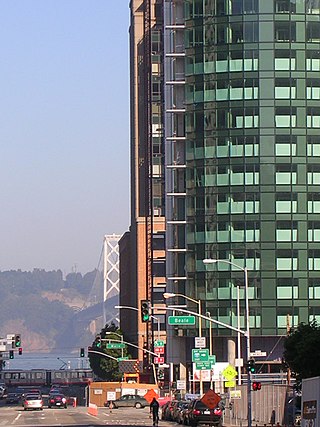
A major transformation of the neighborhood was conceived during the 2000s with the Transbay Terminal Replacement Project, which broke ground in August 2010 and opened in August 2018. In addition, new high rise residential projects like One Rincon Hill, 300 Spear Street, and Millennium Tower are transforming the San Francisco skyline. In 2005, the Transbay Joint Powers Authority proposed to raise height limits around the new Transbay Terminal.[26] This led to proposals for more supertall buildings, such as Renzo Piano's proposal for a group of towers that includes two 1,200-foot. (366m) towers, two 900-foot (274m) towers, and a 600-foot (183m) tower. The 1,200-foot (366m) towers would have been the tallest buildings in the United States outside of New York City and Chicago.[27][28]Renzo Piano's complex has since been canceled, and replaced by a newer project entitled 50 First Street, to be designed by Skidmore, Owings & Merrill (SOM). In addition, the Cesar Pelli and Hines Group have also proposed another 1,070-foot (366m), 61-story office tower.[29] The Salesforce Tower, formerly named the Transbay Tower, was completed May 2018.
Economy
The neighborhood consists of warehouses, auto repair shops, nightclubs, residential hotels, art spaces, loft apartments, furniture showrooms, condominiums and technology companies.[30] A major children's park was also built for the area on top of Moscone South. The park features a large play area, an ice skating rink, a bowling alley, a restaurant, the Children's Creativity Museum[31] and the restored carousel[32] from Playland-At-the-Beach. The children's park and Children's Creativity Museum are joined to the Yerba Buena Gardens by a footbridge.
The South of Market Health Center ensured health care access to comprehensive care by providing mental and physical health problem services to close the gap on health disparities.[51] It provides agencies with programs including finances, health care, food assistance or job training. In terms of sexual health, the district's San Francisco City Clinic offers sexually transmitted disease (STD) tests and treatment, in addition to counseling and condoms.
211 United Way Bay Area is a service that connects callers with services and programs: including basic needs, physical and mental health, employment assistance, and seniors support.[52]
Miscellaneous attractions
The local Academy of Art University owns several buildings in the neighborhood, primarily for academic and administrative purposes.[53]
SOMArts, one of four cultural center facilities owned by the City and County of San Francisco, is located on Brannan Street between 8th and 9th streets.[58]
Due to the area's gay rights history, the Folsom Street Fair is held on Folsom St between 7th and 12th Streets (now between 8th and 13th Streets).[65] The smaller and less-commercialized leather subculture-oriented Up Your Alley Fair (commonly referred to as the Dore Alley Fair) is held in late July on and around Folsom St.[66] Also home to the annual How Weird Street Faire featuring dancing and costumes, held in early May along seven city blocks including Howard and Second streets.[67]
Several Filipino cultural events are held such as Filipino American History Month Celebration at the Asian Art Museum in October and Pistahan Parade and Festival in August.
Undiscovered SF, held monthly, promotes economic activity and awareness of SoMa Pilipinas. It supports retail concepts, restaurants, and businesses by giving skill-set building workshops and professional services like accounting and crowdfunding to prepare businesses for growth and sustainability.[68]
In April 2016, the San Francisco Board of Supervisors adopted a resolution that established the SOMA Pilipinas Filipino Cultural Heritage District.[73] The relationship between SOMA Pilipinas and the Philippines is established in the resolution: "Whereas, Filipino immigration patterns to San Francisco are rooted in the conquest and subsequent colonization of the Philippines by the United States in 1898, the American colonial regime in the Philippines from 1899-1946, and ongoing, often unequal and imperialist US-Philippines relations from 1946 to present."[74] The City of San Francisco certified Tagalog as its third official language in 2014, and a 2010 Census illustrated the Filipino population to reach 36,347 Filipino in the city which 5,106 live in South of Market District. Within the SOMA Pilipinas' official borders—Market to the north, Brannan to the south, 2nd the east, and 11th to the west—are several streets named after Filipino historical figures, including Rizal, Lapu-Lapu, and Mabini, and are located between Folsom and Harrison Streets. A former Filipino district existed near North Beach, prior to its gentrification, called Manilatown.
San Francisco, officially the City and County of San Francisco, is a commercial, financial, and cultural center in Northern California. With a population of 808,437 residents as of 2022, San Francisco is the fourth most populous city in the U.S. state of California. The city covers a land area of 46.9 square miles at the end of the San Francisco Peninsula, making it the second-most densely populated large U.S. city after New York City and the fifth-most densely populated U.S. county, behind only four New York City boroughs. Among the 92 U.S. cities proper with over 250,000 residents, San Francisco was ranked first by per capita income and sixth by aggregate income as of 2022. Colloquial nicknames for San Francisco include Frisco, San Fran, The City, and SF.
Folsom Street Fair (FSF) is an annual BDSM and leather subculture street fair, held in September that concludes San Francisco's "Leather Pride Week". The Folsom Street Fair, sometimes referred to simply as "Folsom", takes place on the last Sunday in September, on Folsom Street between 8th and 13th Streets, in San Francisco's South of Market district.
The Key System was a privately owned company that provided mass transit in the cities of Oakland, Berkeley, Alameda, Emeryville, Piedmont, San Leandro, Richmond, Albany, and El Cerrito in the eastern San Francisco Bay Area from 1903 until 1960, when it was sold to a newly formed public agency, AC Transit. The Key System consisted of local streetcar and bus lines in the East Bay, and commuter rail and bus lines connecting the East Bay to San Francisco by a ferry pier on San Francisco Bay, later via the lower deck of the Bay Bridge. At its height during the 1940s, the Key System had over 66 miles (106 km) of track. The local streetcars were discontinued in 1948 and the commuter trains to San Francisco were discontinued in 1958. The Key System's territory is today served by BART and AC Transit bus service.
Yerba Buena Gardens is the name for two blocks of public parks located between Third and Fourth, Mission and Folsom Streets in the South of Market (SoMA) neighbourhood of San Francisco, California. The first block bordered by Mission and Howard Streets was opened on October 11, 1993. The second block, between Howard and Folsom Streets, was opened in 1998, with a dedication to Martin Luther King Jr. by Mayor Willie Brown. A pedestrian bridge over Howard Street connects the two blocks, sitting on top of part of the Moscone Center convention center. The Yerba Buena Gardens were planned and built as the final centerpiece of the Yerba Buena Redevelopment Area which includes the Yerba Buena Center for the Arts. Yerba Buena Gardens Conservancy operates the property on behalf of the City and County of San Francisco.
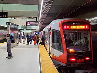
The Central Subway is a Muni Metro light rail tunnel in San Francisco, California, United States. It runs between Chinatown station in Chinatown and a portal in South of Market (SoMa), with intermediate stops at Union Square/Market Street station in Union Square and Yerba Buena/Moscone station in SoMa. A surface portion runs through SoMa to connect to the previously existing T Third Street line at 4th and King station.
The Financial District is a neighborhood in San Francisco, California, United States, that serves as its main central business district and had 372,829 jobs according to U.S. census tracts as of 2012-2016. It is home to the city's largest concentration of corporate headquarters, law firms, insurance companies, real estate firms, savings and loan banks, and other financial institutions. Multiple Fortune 500 companies headquartered in San Francisco have their offices in the Financial District, including Wells Fargo, Salesforce, Uber, Gap, and Williams-Sonoma.
Mission Street is a north-south arterial thoroughfare in Daly City and San Francisco, California that runs from Daly City's southern border to San Francisco's northeast waterfront. The street and San Francisco's Mission District through which it runs were named for the Spanish Mission Dolores, several blocks away from the modern route. Only the southern half is historically part of El Camino Real, which connected the missions. Part of Mission Street in Daly City is signed as part of State Route 82.
The George R. Moscone Convention Center, popularly known as the Moscone Center, is the largest convention and exhibition complex in San Francisco, California, United States. The complex consists of three main halls spread out across three blocks and 87 acres (35 ha) in the South of Market neighborhood. The convention center originally opened in 1981. It is named after former San Francisco mayor George Moscone, who was assassinated in November 1978.
Rincon Hill is a neighborhood in San Francisco, California. It is one of San Francisco's many hills, and one of its original "Seven Hills". The relatively compact neighborhood is bounded by Folsom Street to the north, the Embarcadero to the east, Bryant Street on the south, and Essex Street to the west. Named after Rincon Point that formerly extended into the bay there, Rincon Hill is located just south of the Transbay development area, part of the greater South of Market area. The hill is about 100 feet tall.
The San Francisco Transbay development is a completed redevelopment plan for the neighborhood surrounding the Transbay Transit Center site, South of Market near the Financial District in San Francisco, California. The new transit center replaced the since-demolished San Francisco Transbay Terminal, and new skyscrapers, such as Salesforce Tower, took advantage of the height increases allowed through the San Francisco Transit Center District Plan. The sale of several land parcels formerly owned by the state and given to the managing Transbay Joint Powers Authority helped finance the construction of the transit center.
St. Patrick's Catholic Church is a Catholic church in San Francisco, California, founded in 1851. It is located at 756 Mission Street, between 3rd and 4th streets, across the street from Yerba Buena Gardens in the heart of the South of Market district.
Howard Street is a street in San Francisco's South of Market District (SoMa). It begins after branching off from Van Ness Avenue near the Mission District, and then runs parallel to and between of Mission Street and Folsom Street towards The Embarcadero. Howard Street has the Moscone Center, Rincon Plaza, Yerba Buena Center for the Arts, and The University of San Francisco along its corridor.
Folsom Street is a street in San Francisco which begins perpendicular to Alemany Boulevard in San Francisco's Bernal Heights district and ends perpendicular to the Embarcadero on the San Francisco Bay. For its southern half, Folsom Street runs north–south, but it turns northeasterly at 13th street. It runs through San Francisco's Bernal Heights district, Mission District, SoMa District, Yerba Buena District, and South Beach district.
Yerba Buena/Moscone station is an underground Muni Metro light rail station located at 4th Street and Folsom Street in the South of Market (SoMa) district of San Francisco, California. It is named for the adjacent Yerba Buena Gardens and Moscone Convention Center. It opened on November 19, 2022, as part of the Central Subway project. The station is served by the T Third Street line which runs between Chinatown and Sunnydale.
Four Seasons Private Residences at 706 Mission Street, San Francisco is a 43-story, 510 ft (160 m) residential skyscraper under construction in the South of Market district of San Francisco, California. Located across the street from Yerba Buena Gardens and Moscone Center, the tower site is bounded by Mission Street on the south and 3rd Street on the east, and will incorporate the historic Aronson Building in its design. The tower will contain up to 190 condominiums on the upper floors and a permanent home for the Mexican Museum on the bottom four floors.
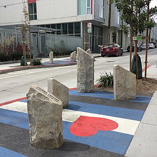
The San Francisco South of Market Leather History Alley consists of four works of art that honor the history of gay and lesbian leather culture in South of Market, San Francisco. The art is embedded in Ringold Street, an alley between 8th and 9th Street. The installation opened in 2017. The alley is part of the Leather and LGBTQ Cultural District.
The Leather and LGBTQ Cultural District is a cultural district in San Francisco's South of Market (SOMA) neighborhood commemorating the history and culture of the leather subculture active in the area for approximately half a century. The San Francisco Board of Supervisors established the district with legislation signed into law by the mayor on May 9, 2018. A ribbon cutting was held on June 12 that year outside the Stud on 9th St.
The San Francisco Redevelopment Agency (SFRA) was an urban renewal agency active from 1948 until 2012, with purpose to improve the urban landscape through "redesign, redevelopment, and rehabilitation" of specific areas of the city.
1 2 3 Rubin, Gayle. "The Miracle Mile: South of Market and Gay Male Leather, 1962-1997" in Reclaiming San Francisco: History, Politics, Culture (City Light Books, 1998).
↑ Mick Sinclair, San Francisco: A Cultural and Literary History, Interlink, 2003, ISBN1566564891, p. 220
↑ Gayle S. Rubin, "The Miracle Mile. South of Market and Gay Male Leather, 1962-1997", in Recllaiming San Francisco: History, Politics, Culture, edited by James Brook, Chris Carlsson, Nancy J. Peters, San Francisco, City Lights, 2001, ISBN0872863352, pp. 247-272.
↑ Patrick Hoge (April 20, 2012). "Ustream downsizes S.F. offices". San Francisco Business Times. American City Business Journals. Retrieved February 15, 2015.
↑ "Contact." Founders Den. Retrieved on August 3, 2015. "Founders Den is located in an 8500 sqft facility in the heart of SoMa[...]665 3rd St., Suite 150, San Francisco, CA 94107."
This page is based on this Wikipedia article Text is available under the CC BY-SA 4.0 license; additional terms may apply. Images, videos and audio are available under their respective licenses.