St. Mary's, Alaska

Last updated

Saint Mary's
Negeqliq (Central Yupik)
USA Alaska location map.svg
Red pog.svg
Saint Mary's
Location within the state of Alaska
Coordinates: 62°2′43″N163°13′7″W / 62.04528°N 163.21861°W / 62.04528; -163.21861
CountryUnited States
State Alaska
Census Area Kusilvak Census Area
Incorporated August 2, 1967 [1]
Government
   Mayor William F. Alstrom [2]
   State senator Donald Olson (D)
   State rep. Neal Foster (D)
Area
[3]
  Total51.57 sq mi (133.56 km2)
  Land44.60 sq mi (115.53 km2)
  Water6.96 sq mi (18.03 km2)
Population
 (2020)
  Total599
  Density13.43/sq mi (5.19/km2)
ZIP code
99658
Area code 907
FIPS code 02-66140

St. Mary's (Central Yupik : Negeqliq) is a city in Kusilvak Census Area, Alaska, United States. The adjacent village of Andreafsky (historically known as Clear River) joined with St. Mary's in 1980. [4] At the 2010 census the population was 507, up from 500 in 2000. By 2018, the population was estimated to be 567.

Contents

Within Saint Mary's there are two federally-recognized tribes the Algaaciq Native Village and the Yuupiit of Andreafsky. [5]

Geography and climate

St. Mary's is located at 62°2′43″N163°13′7″W / 62.04528°N 163.21861°W / 62.04528; -163.21861 (62.045305, -163.218629). [6]

According to the United States Census Bureau, the city has a total area of 50.2 square miles (130 km2), of which, 44.0 square miles (114 km2) of it is land and 6.3 square miles (16 km2) of it (12.47%) is water.

Climate data for St. Mary's (1961–1990 normals, extremes 1967–1983)
MonthJanFebMarAprMayJunJulAugSepOctNovDecYear
Record high °F (°C)46
(8)
41
(5)
43
(6)
60
(16)
78
(26)
80
(27)
83
(28)
95
(35)
73
(23)
57
(14)
43
(6)
41
(5)
95
(35)
Mean maximum °F (°C)34.8
(1.6)
34.3
(1.3)
38.4
(3.6)
47.7
(8.7)
65.1
(18.4)
73.5
(23.1)
76.4
(24.7)
73.9
(23.3)
65.0
(18.3)
49.4
(9.7)
38.1
(3.4)
35.0
(1.7)
79.1
(26.2)
Mean daily maximum °F (°C)14.2
(−9.9)
15.7
(−9.1)
23.5
(−4.7)
33.3
(0.7)
50.4
(10.2)
59.9
(15.5)
63.8
(17.7)
61.7
(16.5)
53.0
(11.7)
36.8
(2.7)
21.9
(−5.6)
14.5
(−9.7)
37.5
(3.1)
Daily mean °F (°C)9.0
(−12.8)
6.6
(−14.1)
15.2
(−9.3)
24.3
(−4.3)
42.2
(5.7)
50.8
(10.4)
55.2
(12.9)
53.8
(12.1)
44.7
(7.1)
30.2
(−1.0)
16.9
(−8.4)
6.6
(−14.1)
29.6
(−1.3)
Mean daily minimum °F (°C)1.6
(−16.9)
0.3
(−17.6)
6.1
(−14.4)
17.6
(−8.0)
32.8
(0.4)
41.7
(5.4)
46.5
(8.1)
44.6
(7.0)
36.0
(2.2)
23.6
(−4.7)
9.6
(−12.4)
0.5
(−17.5)
21.8
(−5.7)
Mean minimum °F (°C)−25.2
(−31.8)
−29.7
(−34.3)
−21.6
(−29.8)
−7.9
(−22.2)
19.6
(−6.9)
31.8
(−0.1)
38.0
(3.3)
34.1
(1.2)
23.4
(−4.8)
2.4
(−16.4)
−11.1
(−23.9)
−27.1
(−32.8)
−37.7
(−38.7)
Record low °F (°C)−44
(−42)
−42
(−41)
−40
(−40)
−23
(−31)
2
(−17)
26
(−3)
30
(−1)
29
(−2)
15
(−9)
−13
(−25)
−29
(−34)
−41
(−41)
−44
(−42)
Average precipitation inches (mm)1.04
(26)
0.71
(18)
0.74
(19)
0.76
(19)
1.03
(26)
2.02
(51)
2.62
(67)
3.09
(78)
2.34
(59)
1.70
(43)
1.63
(41)
1.45
(37)
19.13
(486)
Average snowfall inches (cm)10.2
(26)
4.8
(12)
8.0
(20)
5.8
(15)
1.2
(3.0)
0.9
(2.3)
0.0
(0.0)
0.0
(0.0)
0.7
(1.8)
5.8
(15)
15.0
(38)
15.4
(39)
44.7
(114)
Average precipitation days (≥ 0.01 inch)9.46.56.87.38.613.014.916.914.813.411.610.9134.1
Average snowy days (≥ 0.1 inch)9.45.97.67.81.90.90.00.00.65.611.49.961.0
Source 1: WRCC [7]
Source 2: XMACIS (snowfall) [8]

Demographics

Historical population
CensusPop.Note
1960 225
1970 38470.7%
1980 382−0.5%
1990 44115.4%
2000 50013.4%
2010 5071.4%
2020 59918.1%
U.S. Decennial Census [9]

Saint Mary's first appeared on the 1960 U.S. Census as an unincorporated village. It was formally incorporated in 1967.

Sunrise over St. Mary's. St Marys AK.JPG
Sunrise over St. Mary's.

As of the census [10] of 2000, there were 500 people, 137 households, and 90 families residing in the city. The population density was 11.4 inhabitants per square mile (4.4/km2). There were 186 housing units at an average density of 4.2 per square mile (1.6/km2). The racial makeup of the city was 11.20% White, 87.20% American Indian/Alaska Native. 0.40% of the population were Hispanic or Latino of any race.

There were 137 households, out of which 45.3% had children under the age of 18 living with them, 40.9% were married couples living together, 17.5% had a female householder with no husband present, and 34.3% were non-families. 28.5% of all households were made up of individuals, and 2.2% had someone living alone who was 65 years of age or older. The average household size was 3.58 and the average family size was 4.60.

In the city, the age distribution of the population shows 39.6% under the age of 18, 8.6% from 18 to 24, 30.4% from 25 to 44, 15.0% from 45 to 64, and 6.4% who were 65 years of age or older. The median age was 26 years. For every 100 females, there were 122.2 males. For every 100 females age 18 and over, there were 111.2 males.

The median income for a household in the city was $39,375, and the median income for a family was $31,875. Males had a median income of $35,313 versus $22,250 for females. The per capita income for the city was $15,837. About 21.5% of families and 20.4% of the population were below the poverty line, including 28.2% of those under age 18 and 10.3% of those age 65 or over.

See also

Related Research Articles

<span class="mw-page-title-main">Kusilvak Census Area, Alaska</span> Census area in Alaska, United States

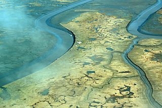
Kusilvak Census Area, formerly known as Wade Hampton Census Area, is a census area located in the U.S. state of Alaska. As of the 2020 census, the population was 8,368, up from 7,459 in 2010. It is part of the Unorganized Borough and therefore has no borough seat. Its largest community is the city of Hooper Bay, on the Bering Sea coast.

<span class="mw-page-title-main">False Pass, Alaska</span> City in Alaska, United States

False Pass is a city on Unimak Island, in the Aleutians East Borough of southwestern Alaska, United States. Although the population was marked 397 including seasonal fish processing plant workers at the 2020 census, approximately 35 residents call it home year-round.

<span class="mw-page-title-main">Eek, Alaska</span> City in Alaska, United States

Eek is a city in Bethel Census Area, Alaska, United States. As of the 2020 census there were 404 residents, the majority being Alaska Natives.

<span class="mw-page-title-main">Lower Kalskag, Alaska</span> City in Alaska, United States

Lower Kalskag is a city in Bethel Census Area, Alaska, United States. It is twenty-six miles west of Aniak. At the 2010 census the population was 282, up from 267 in 2000.

Upper Kalskag is a city in Bethel Census Area, Alaska, United States. It is thirty miles west of Aniak. At the 2010 census the population was 210, down from 230 in 2000.

<span class="mw-page-title-main">Kachemak, Alaska</span> City in Alaska, United States

Kachemak, locally known as Kachemak City, is a small second-class city in the southern portion of the Kenai Peninsula Borough, Alaska, United States. The city consists of several subdivisions and other miscellaneous properties along an approximately 2-mile (3.2 km) stretch of East End Road, adjoining the northeast corner of the much larger city of Homer. The population grew from 431 as of the 2010 census to 576 at the 2020 census.

<span class="mw-page-title-main">Golovin, Alaska</span> City in Alaska, United States

Golovin is a city in Nome Census Area, Alaska, United States. At the 2010 census the population was 156, up from 144 in 2000.

Koyuk is a city in the Nome Census Area, Alaska, United States. The population was 332 at the 2010 census, up from 297 in 2000.

St. Michael, historically referred to as Saint Michael, is a city in Nome Census Area, Alaska. The population was 401 at the 2010 census, up from 368 in 2000.

Stebbins is a city in Nome Census Area, Alaska, United States. At the 2010 census the population was 556, up from 547 in 2000.

<span class="mw-page-title-main">White Mountain, Alaska</span> City in Alaska, United States

White Mountain is a city in Nome Census Area, Alaska, United States. The population was 190 at the 2010 census, down from 203 in 2000. The city is an Iġaluŋmiut Inupiat village, with historical influences from and relationships with Qawiaraq Inupiat and Golovin and Elim Yup’iks. 86.2% of the population is Alaska Native or part Native. Subsistence activities are prevalent. White Mountain is the only village on the Seward Peninsula located inland, not on the ocean.

<span class="mw-page-title-main">Buckland, Alaska</span> City in Alaska, United States

Buckland is a city in Northwest Arctic Borough, Alaska, United States. At the 2010 census the population was 416, up from 406 in 2000. It takes its English name from the Buckland River, which in turn takes its name from Oxford University professor William Buckland.

<span class="mw-page-title-main">Alakanuk, Alaska</span> City in Alaska, United States

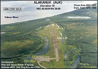
Alakanuk(ah-LUG-uh-nuck) is a second class city in the Kusilvak Census Area of the Unorganized Borough in the western part of the U.S. state of Alaska. As of the 2010 census, the population of the city was 677, up from 652 in 2000.

Kotlik is a city in Kusilvak Census Area, Alaska, United States. At the 2010 census the population was 577, down from 591 in 2000.

Mountain Village is a city in Kusilvak Census Area, Alaska, United States, located on the Yukon River near the Yukon-Kuskokwim Delta. At the 2010 census the population was 813, up from 755 in 2000.

Nunam Iqua, formerly called Sheldon Point, is a city in the Kusilvak Census Area in the U.S. state of Alaska. At the 2010 census the population was 187, up from 164 in 2000.

Grayling is a city in Yukon-Koyukuk Census Area, Alaska, United States. At the 2010 census the population was 194, unchanged from 2000. Since 1977, the Athabaskan village has seen a surge of interest on odd-numbered years, when it is the site of a checkpoint during the Iditarod Trail Sled Dog Race. It is situated after the checkpoint at Anvik and before Eagle Island.

<span class="mw-page-title-main">Holy Cross, Alaska</span> City in Alaska

Holy Cross is a city in Yukon-Koyukuk Census Area, Alaska, United States. At the 2010 census the population was 178, down from 227 in 2000.

<span class="mw-page-title-main">Huslia, Alaska</span> City in Alaska, United States

Huslia is a city in Yukon-Koyukuk Census Area, Alaska, United States. Rarely known as Hussliakatna, it is inhabited by Koyukuk-hotana Athabascans. The population was 293 at the 2000 census and 275 as of the 2010 census.

Shageluk is a city in Yukon-Koyukuk Census Area, Alaska, United States. At the 2010 census the population was 83, down from 129 in 2000.

References

  1. 1996 Alaska Municipal Officials Directory. Juneau: Alaska Municipal League/Alaska Department of Community and Regional Affairs. January 1996. p. 129.
  2. 2015 Alaska Municipal Officials Directory. Juneau: Alaska Municipal League. 2015. p. 135.
  3. "2020 U.S. Gazetteer Files". United States Census Bureau. Retrieved October 29, 2021.
  4. "The History of Andreafsky". ExploreNorth. Retrieved December 22, 2016.
  5. Nicole Herman-Mercer, 2010. Indigenous environmental knowledge: past cases and future prospects
  6. "US Gazetteer files: 2010, 2000, and 1990". United States Census Bureau. February 12, 2011. Retrieved April 23, 2011.
  7. "1961-1990 Monthly Climate Summary, ST MARYS, ALASKA (508105)". Western Regional Climate Center. Archived from the original on January 28, 2024. Retrieved January 28, 2024.
  8. XMACIS
  9. "Census of Population and Housing". Census.gov. Retrieved June 4, 2015.
  10. "U.S. Census website". United States Census Bureau . Retrieved January 31, 2008.