Bering Air is an American airline headquartered in Nome, Alaska, United States. It operates domestic scheduled passenger and charter airline services, as well as air ambulance and helicopter services. Its main base is Nome Airport, with hubs at Ralph Wien Memorial Airport (Kotzebue) and Unalakleet Airport.

Nome Airport is a state-owned public-use airport located two nautical miles (4 km) west of the central business district of Nome, a city in the Nome Census Area of the U.S. state of Alaska.
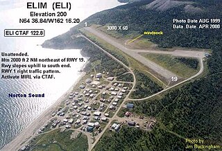
Elim Airport is a state-owned, public-use airport located three nautical miles (6 km) southwest of the central business district of Elim, a city in the Nome Census Area of the U.S. state of Alaska.
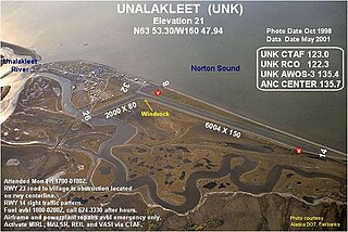
Unalakleet Airport is a state-owned public-use airport located one nautical mile (2 km) north of the central business district of Unalakleet, a city in the Nome Census Area of the U.S. state of Alaska.

Gambell Airport is a public airport located in Gambell, a city in the Nome Census Area of the U.S. state of Alaska. The airport is owned by the state.
St. Mary's Airport is a public airport located four miles (6 km) west of the central business district of St. Mary's, in the Kusilvak Census Area of the U.S. state of Alaska. This airport is publicly owned by the State of Alaska Department of Transportation and Public Facilities (DOT&PF) - Northern Region.

Brevig Mission Airport is a state-owned public-use airport located in Brevig Mission, a city in the Nome Census Area of the U.S. state of Alaska.
Koyuk Alfred Adams Airport is a state-owned public-use airport located in Koyuk, a city in the Nome Census Area of the U.S. state of Alaska.

White Mountain Airport is a state-owned public-use airport located one nautical mile north of the central business district of White Mountain, a city in the Nome Census Area of the U.S. state of Alaska.

Shishmaref Airport is a state-owned public-use airport located one nautical mile (1.85 km) south of the central business district of Shishmaref, a village in the Nome Census Area of the U.S. state of Alaska. It has one asphalt paved runway designated 5/23 and measuring 5,000 x 70 ft.. Shishmaref is located on Sarichef Island in the Chukchi Sea, just north of the Bering Strait and five miles from the mainland.
Wales Airport is a state-owned public-use airport located one nautical mile (2 km) northwest of the central business district of Wales, a city in the Nome Census Area of the U.S. state of Alaska.
Teller Airport is a state-owned public-use airport located two nautical miles (4 km) south of the central business district of Teller, a city in the Nome Census Area of the U.S. state of Alaska.
Shaktoolik Airport is a state-owned public-use airport located one nautical mile (1.8 km) northwest of the central business district of Shaktoolik, a city in the Nome Census Area of the U.S. state of Alaska.
Savoonga Airport is a state-owned public-use airport located two nautical miles (4 km) south of the central business district of Savoonga, a city in the Nome Census Area of the U.S. state of Alaska. Savoonga is located on St. Lawrence Island in the Bering Sea.
St. Michael Airport is a state-owned, public-use airport located two nautical miles (4 km) west of the central business district of St. Michael, a city in the Nome Census Area of the U.S. state of Alaska.
Port Clarence Coast Guard Station is a private-use airport located one nautical mile (2 km) northeast of the central business district of Port Clarence in the Nome Census Area of the U.S. state of Alaska. It is owned by the U.S. Government.
Tin City LRRS Airport is a military airport located one nautical mile (1.85 km) east of the historic location of Tin City, in the Nome Census Area of the U.S. state of Alaska. It is owned by the U.S. Air Force.
Pilot Station Airport is a state-owned public-use airport located one nautical mile (2 km) southwest of the central business district of Pilot Station, a city in the Kusilvak Census Area of the U.S. state of Alaska.
Council Airport is a state-owned public-use airport located one nautical mile (1.8 km) north of the central business district of Council, in the Nome Census Area in the U.S. state of Alaska.
Nome City Field is a state-owned public-use airport located one nautical mile north of the central business district of Nome, a city in the Nome Census Area of the U.S. state of Alaska.
