Taconic orogeny

Last updated
Illustration of the Taconic orogeny Taconic orogeny.gif
Illustration of the Taconic orogeny

The Taconic orogeny was a mountain building period that ended 440 million years ago (Ma) and affected most of modern-day New England. A great mountain chain formed from eastern Canada down through what is now the Piedmont of the east coast of the United States. As the mountain chain eroded in the Silurian and Devonian periods, sediment spread throughout the present-day Appalachians and midcontinental North America. [1]

Contents

New England and Canada

Beginning in Cambrian time, about 550 Ma, the Iapetus Ocean began to close. The weight of accumulating sediments, in addition to compressional forces in the crust, forced the eastern edge of the North American continent to fold gradually downward. [2] In this manner, shallow-water carbonate deposition that had persisted on the continental shelf margin through late Cambrian into early Ordovician time, gave way to fine-grained clastic deposition and deeper water conditions during the middle Ordovician. In this period a convergent plate boundary developed along the eastern edge of a small island chain. Crustal material beneath the Iapetus Ocean sank into the mantle along a subduction zone with an eastward-dipping orientation. [2] Dewatering of the down-going plate led to hydration of the peridotites in the overlying mantle wedge, lowering their melting point. This led to partial melting of the peridotites within the mantle wedge producing magma that returned to the surface to form the offshore Taconic (or Bronson Hill) island arc.

By the Late Ordovician, this island arc had collided with the North American continent. The sedimentary and igneous rock between the land masses were intensely folded and faulted and were subjected to varying degrees of metamorphism. This was the final episode of the Taconic orogeny. [1] Cameron's Line is the suture zone that is modern-day evidence of the collision of the island arc and the continent. [3] Cameron's Line winds southward out of New England into western Connecticut and passes through southern New York across the Bronx, following the general trend of the East River. It extends beneath sedimentary cover on Staten Island and southward beneath the coastal plain of New Jersey. In general, basement rocks to the west of Cameron's Line are regarded as autochthonous, meaning that they have not been significantly displaced by tectonic processes. The rocks to the west of Cameron's Line include metamorphosed sedimentary material originally comprising ancient continental slope, rise, and shelf deposits. The rocks to the east of Cameron's Line are allochthonous, which means they have been shoved westward over autochthonous basement rocks on the order of many tens or even hundreds of kilometers. These rocks were originally deposited as sediments in a deep water basin. Cameron's Line represents the trace of a subduction zone that ceased when the Taconic island arc collided with, and became accreted onto, the eastern margin of North America. Many of the rocks east of Cameron's Line were once part of the floor of the Iapetus Ocean. [2]

When the Taconic orogeny subsided during the late Ordovician (about 440 Ma), subduction ended, culminating in the accretion of the Iapetus Terrane onto the eastern margin of the continent. This resulted in the formation of a great mountain range throughout New England and eastern Canada, and perhaps to a lesser degree, southward along the region that is now the Piedmont of eastern North America. The expanded continental margin gradually stabilized. Erosion continued to strip away sediments from upland areas. Inland seas covering the midcontinent gradually expanded eastward into the New York Bight region and became the site of shallow clastic and carbonate deposition. This tectonically quiet period persisted until the late Devonian (about 360 Ma) when the next period of mountain-building began, the Acadian orogeny. [1]

Southern Appalachians

In the southern Appalachians of Alabama, Georgia, and North Carolina, the Taconic orogeny was not associated with collision of an island arc with ancient North America (Laurentia). Geologists working in these areas have long puzzled over the "missing" arc terrane typical of Taconic-aged rocks in New England and Canada. [4] Instead, the Iapetus margin of this part of Laurentia appears to have faced a back-arc basin during the Ordovician, suggesting that Iapetus oceanic crust was subducted beneath Laurentia—unlike the New England and Canadian segments of the margin, where Laurentia was on the subducting plate. [5] [6]

In contrast to the Ordovician geologic history of New England, rocks in Alabama, Georgia, Tennessee, and North Carolina—including those of the Dahlonega gold belt [7] (Georgia and North Carolina), Talladega belt [8] [9] (Alabama and Georgia), and eastern Blue Ridge (Georgia, Tennessee, and North Carolina)—are not typical of a volcanic arc in its strictest sense. [10] Instead, these rocks have geochemical and other characteristics typical of back-arc basins, which form behind the volcanic arc on the overriding plate. [5] [6] The presence of these early-middle Ordovician (480 - 460 million year old) back-arc basin rocks in direct or faulted contact with rocks of the Laurentian shelf and slope-rise in the southern Appalachians suggests they were built on the margin of Laurentia, beyond the edge of the continental shelf-slope break. [9]

In the southern Appalachians, the Ordovician Laurentian margin probably resembled that seen in the modern Sea of Japan, with the continental mainland separated from a volcanic arc by a narrow, "marginal" seaway. Other lines of evidence supporting a back-arc, Sea of Japan-style tectonic model for the Taconic orogeny in the southern Appalachians include mixing of Ordovician and Grenville (ca. 1 billion year old) detrital zircons in metamorphosed sedimentary sequences, and interlayering of metamorphosed Ordovician volcanic rocks with sedimentary rocks derived from the Laurentian margin. [5] [6]

Relation with the Famatinian orogeny

It has been suggested that the coeval Famatinian orogeny in western Gondwana (South America) is the "southward" continuation of the Taconic orogeny. [note 1] This has been explained by adding that Laurentia could have collided with western Gondwana in early Paleozoic times during the closure of the Iapetus Ocean. [11] According to this view the Cuyania terrane would be an allochthonous block of Laurentian origin that was left in Gondwana. But such views are challenged since Cuyania is alternatively suggested to have drifted across Iapetus Ocean as a microcontinent starting in Laurentia and accreting then to Gondwana. A third model claims Cuyania is para-autochthonous and arrived at its current place by strike-slip faults starting not from Laurentia but from Gondwana. [12]

Aftermath

The "Taconic Unconformity" is an angular unconformity exposed from eastern New York State to the Gaspe peninsula Angular unconformity mcr1.JPG
The "Taconic Unconformity" is an angular unconformity exposed from eastern New York State to the Gaspe peninsula

As the Taconic orogeny subsided in early Silurian time, uplifts and folds in the Hudson Valley region were beveled by erosion. Upon this surface sediments began to accumulate, derived from remaining uplifts in the New England region. The evidence for this is the Silurian Shawangunk Conglomerate, a massive, ridge-forming quartz sandstone and conglomerate formation, which rests unconformably on a surface of older gently- to steeply-dipping pre-Silurian age strata throughout the region. This ridge of Shawangunk Conglomerate extends southward from the Hudson Valley along the eastern front of the Catskills. It forms the impressive caprock ridge of the Shawangunk Mountains west of New Paltz. To the south and west it becomes the prominent ridge-forming unit that crops out along the crest of Kittatinny Mountain in New Jersey. [2]

Through Silurian time, the deposition of coarse alluvial sediments gave way to shallow marine fine-grained muds, and eventually to clear-water carbonate sediment accumulation with reefs formed from the accumulation of calcareous algae and the skeletal remains of coral, stromatoporoids, brachiopods, and other ancient marine fauna. The episodic eustatic rise and fall of sea level caused depositional environments to change or to shift laterally. As a result, the preserved faunal remains and the character and composition of the sedimentary layers deposited in any particular location varied through time. The textural or compositional variations of the strata, as well as the changing fossil fauna preserved, are used to define the numerous sedimentary formations of Silurian through Devonian age preserved throughout the region. [2]

See also

Notes

  1. In other words what is at present the southern end of the Taconic orogeny would have been connected with what is currently the northern end of the Famatinian orogeny.

Related Research Articles

<span class="mw-page-title-main">Geology of the Appalachians</span> Geologic description of the Appalachian Mountains

The geology of the Appalachians dates back more than 1.2 billion years to the Mesoproterozoic era when two continental cratons collided to form the supercontinent Rodinia, 500 million years prior to the development of the range during the formation of Pangea. The rocks exposed in today's Appalachian Mountains reveal elongate belts of folded and thrust faulted marine sedimentary rocks, volcanic rocks, and slivers of ancient ocean floor—strong evidences that these rocks were deformed during plate collision. The birth of the Appalachian ranges marks the first of several mountain building plate collisions that culminated in the construction of Pangea with the Appalachians and neighboring Anti-Atlas mountains near the center. These mountain ranges likely once reached elevations similar to those of the Alps and the Rocky Mountains before they were eroded.

<span class="mw-page-title-main">Iapetus Ocean</span> Ocean that existed in the late Neoproterozoic and early Paleozoic eras

The Iapetus Ocean was an ocean that existed in the late Neoproterozoic and early Paleozoic eras of the geologic timescale. The Iapetus Ocean was situated in the southern hemisphere, between the paleocontinents of Laurentia, Baltica and Avalonia. The ocean disappeared with the Acadian, Caledonian and Taconic orogenies, when these three continents joined to form one big landmass called Euramerica. The "southern" Iapetus Ocean has been proposed to have closed with the Famatinian and Taconic orogenies, meaning a collision between Western Gondwana and Laurentia.

<span class="mw-page-title-main">Baltica</span> Late-Proterozoic to early-Palaeozoic continent

Baltica is a paleocontinent that formed in the Paleoproterozoic and now constitutes northwestern Eurasia, or Europe north of the Trans-European Suture Zone and west of the Ural Mountains. The thick core of Baltica, the East European Craton, is more than three billion years old and formed part of the Rodinia supercontinent at c.Ga.

<span class="mw-page-title-main">Avalonia</span> Microcontinent in the Paleozoic era

Avalonia was a microcontinent in the Paleozoic era. Crustal fragments of this former microcontinent underlie south-west Great Britain, southern Ireland, and the eastern coast of North America. It is the source of many of the older rocks of Western Europe, Atlantic Canada, and parts of the coastal United States. Avalonia is named for the Avalon Peninsula in Newfoundland.

<span class="mw-page-title-main">Acadian orogeny</span> North American orogeny

The Acadian orogeny is a long-lasting mountain building event which began in the Middle Devonian, reaching a climax in the Late Devonian. It was active for approximately 50 million years, beginning roughly around 375 million years ago (Ma), with deformational, plutonic, and metamorphic events extending into the early Mississippian. The Acadian orogeny is the third of the four orogenies that formed the Appalachian Mountains and subsequent basin. The preceding orogenies consisted of the Grenville and Taconic orogenies, which followed a rift/drift stage in the Neoproterozoic. The Acadian orogeny involved the collision of a series of Avalonian continental fragments with the Laurasian continent. Geographically, the Acadian orogeny extended from the Canadian Maritime provinces migrating in a southwesterly direction toward Alabama. However, the northern Appalachian region, from New England northeastward into Gaspé region of Canada, was the most greatly affected region by the collision.

<span class="mw-page-title-main">Caledonian orogeny</span> Mountain building event caused by the collision of Laurentia, Baltica and Avalonia

The Caledonian orogeny was a mountain-building cycle recorded in the northern parts of the British Isles, the Scandinavian Caledonides, Svalbard, eastern Greenland and parts of north-central Europe. The Caledonian orogeny encompasses events that occurred from the Ordovician to Early Devonian, roughly 490–390 million years ago (Ma). It was caused by the closure of the Iapetus Ocean when the Laurentia and Baltica continents and the Avalonia microcontinent collided.

The Rheic Ocean was an ocean which separated two major paleocontinents, Gondwana and Laurussia (Laurentia-Baltica-Avalonia). One of the principal oceans of the Paleozoic, its sutures today stretch 10,000 km (6,200 mi) from Mexico to Turkey and its closure resulted in the assembly of the supercontinent Pangaea and the formation of the Variscan–Alleghenian–Ouachita orogenies.

<span class="mw-page-title-main">Geology of Georgia (U.S. state)</span> Overview of the geology of the U.S. state of Georgia

The U.S. state of Georgia is commonly divided into four geologic regions that influence the location of the state's four traditional physiographic regions. The four geologic regions include the Appalachian foreland, Blue Ridge, Piedmont, and Coastal Plain. These four geologic regions commonly share names with and typically overlap the four physiographic regions of the state: the Appalachian Plateau and adjacent Valley and Ridge; the Blue Ridge; the Piedmont and the Coastal Plain.

<span class="mw-page-title-main">Laurentia</span> Craton forming the geological core of North America

Laurentia or the North American Craton is a large continental craton that forms the ancient geological core of North America. Many times in its past, Laurentia has been a separate continent, as it is now in the form of North America, although originally it also included the cratonic areas of Greenland and also the northwestern part of Scotland, known as the Hebridean Terrane. During other times in its past, Laurentia has been part of larger continents and supercontinents and consists of many smaller terranes assembled on a network of early Proterozoic orogenic belts. Small microcontinents and oceanic islands collided with and sutured onto the ever-growing Laurentia, and together formed the stable Precambrian craton seen today.

The Precordillera Terrane or Cuyania was an ancient microcontinent or terrane whose history affected many of the older rocks of Cuyo in Argentina. It was separated by oceanic crust from the Chilenia terrane which accreted into it at ~420-390 Ma when Cuyania was already amalgamated with Gondwana. The hypothesized Mejillonia Terrane in the coast of northern Chile is considered by some geologists to be a single block with Cuyania.

<span class="mw-page-title-main">Carolina terrane</span> Exotic terrane from central Georgia to central Virginia in the United States

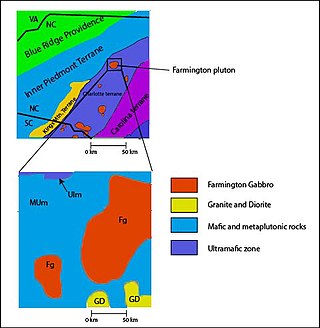
The Carolina Terrane, also called the Carolina Superterrane or Carolinia, is an exotic terrane running ~370 miles (600 km) approximately North-South from central Georgia to central Virginia in the United States. It constitutes a major part of the eastern Piedmont Province.

<span class="mw-page-title-main">Iapetus Suture</span> Ancient geological fault

The Iapetus Suture is one of several major geological faults caused by the collision of several ancient land masses forming a suture. It represents in part the remains of what was once the Iapetus Ocean. Iapetus was the father of Atlas in Greek mythology, making his an appropriate name for what used to be called the 'Proto-Atlantic Ocean'. When the Atlantic Ocean opened, in the Cretaceous period, it took a slightly different line from that of the Iapetus suture, with some originally Laurentian rocks being left behind in north-west Europe and other, Avalonian, rocks remaining as part of Newfoundland.

<span class="mw-page-title-main">Geology of Massachusetts</span>

The geology of Massachusetts includes numerous units of volcanic, intrusive igneous, metamorphic and sedimentary rocks formed within the last 1.2 billion years. The oldest formations are gneiss rocks in the Berkshires, which were metamorphosed from older rocks during the Proterozoic Grenville orogeny as the proto-North American continent Laurentia collided against proto-South America. Throughout the Paleozoic, overlapping the rapid diversification of multi-cellular life, a series of six island arcs collided with the Laurentian continental margin. Also termed continental terranes, these sections of continental rock typically formed offshore or onshore of the proto-African continent Gondwana and in many cases had experienced volcanic events and faulting before joining the Laurentian continent. These sequential collisions metamorphosed new rocks from sediments, created uplands and faults and resulted in widespread volcanic activity. Simultaneously, the collisions raised the Appalachian Mountains to the height of the current day Himalayas.

<span class="mw-page-title-main">Famatinian orogeny</span> Paleozoic geological event in South America

The Famatinian orogeny is an orogeny that predates the rise of the Andes and that took place in what is now western South America during the Paleozoic, leading to the formation of the Famatinian orogen also known as the Famatinian belt. The Famatinian orogeny lasted from the Late Cambrian to at least the Late Devonian and possibly the Early Carboniferous, with orogenic activity peaking about 490 to 460 million years ago. The orogeny involved metamorphism and deformation in the crust and the eruption and intrusion of magma along a Famatinian magmatic arc that formed a chain of volcanoes. The igneous rocks of the Famatinian magmatic arc are of calc-alkaline character and include gabbros, tonalites, granodiorites and trondhjemites. The youngest igneous rocks of the arc are granites.

<span class="mw-page-title-main">Geological history of the Precordillera terrane</span>

The Precordillera terrane of western Argentina is a large mountain range located southeast of the main Andes mountain range. The evolution of the Precordillera is noted for its unique formation history compared to the region nearby. The Cambrian-Ordovian sedimentology in the Precordillera terrane has its source neither from old Andes nor nearby country rock, but shares similar characteristics with the Grenville orogeny of eastern North America. This indicates a rift-drift history of the Precordillera in the early Paleozoic. The Precordillera is a moving micro-continent which started from the southeast part of the ancient continent Laurentia. The separation of the Precordillera started around the early Cambrian. The mass collided with Gondwana around Late Ordovician period. Different models and thinking of rift-drift process and the time of occurrence have been proposed. This page focuses on the evidence of drifting found in the stratigraphical record of the Precordillera, as well as exhibiting models of how the Precordillera drifted to Gondwana.

<span class="mw-page-title-main">Tectonic evolution of Patagonia</span>

Patagonia comprises the southernmost region of South America, portions of which lie on either side of the Argentina-Chile border. It has traditionally been described as the region south of the Rio, Colorado, although the physiographic border has more recently been moved southward to the Huincul fault. The region's geologic border to the north is composed of the Rio de la Plata craton and several accreted terranes comprising the La Pampa province. The underlying basement rocks of the Patagonian region can be subdivided into two large massifs: the North Patagonian Massif and the Deseado Massif. These massifs are surrounded by sedimentary basins formed in the Mesozoic that underwent subsequent deformation during the Andean orogeny. Patagonia is known for its vast earthquakes and the damage they cause.

The Mars Hill Terrane (MHT) is a belt of rocks exposed in the southern Appalachian Mountains, between Roan Mountain, North Carolina and Mars Hill, North Carolina. The terrane is located at the junction between the Western Blue Ridge and the Eastern Blue Ridge Mountains.

Ganderia or Gander Terrane is a terrane in the northern Appalachians which broke off the supercontinent Gondwana c.570 million years ago (Ma) together with Avalonia, Megumia, and Carolinia.

<span class="mw-page-title-main">Geology of North Carolina</span>

The geology of North Carolina includes ancient Proterozoic rocks belonging to the Grenville Province in the Blue Ridge. The region experienced igneous activity and the addition of new terranes and orogeny mountain building events throughout the Paleozoic, followed by the rifting of the Atlantic Ocean and the deposition of thick sediments in the Coastal Plain and offshore waters.

The Grampian orogeny was an orogeny mountain building event which affected Scotland in the middle of the Ordovician. At the time, Scotland was part of proto-North American continent Laurentia.

References

  1. 1 2 3 PD-icon.svg This article incorporates public domain material from Valley and Ridge Province. United States Geological Survey.
  2. 1 2 3 4 5 PD-icon.svg This article incorporates public domain material from The Highlands Province. United States Geological Survey.
  3. Schneider, Daniel B. (August 22, 1999). "F.Y.I." New York Times. Retrieved 1 May 2010.
  4. Staal, C. R. van; Whalen, J. B.; McNicoll, V. J.; Pehrsson, S.; Lissenberg, C. J.; Zagorevski, A.; Breemen, O. van; Jenner, G. A. (2007-01-01). "The Notre Dame arc and the Taconic orogeny in Newfoundland". Geological Society of America Memoirs. 200: 511–552. doi:10.1130/2007.1200(26). ISBN   978-0-8137-1200-0. ISSN   0072-1069.
  5. 1 2 3 Tull, James; Holm-Denoma, Christopher S.; Barineau, Clinton I. (2014-07-01). "Early to Middle Ordovician back-arc basin in the southern Appalachian Blue Ridge: Characteristics, extent, and tectonic significance". Geological Society of America Bulletin. 126 (7–8): 990–1015. Bibcode:2014GSAB..126..990T. doi:10.1130/B30967.1. ISSN   0016-7606.
  6. 1 2 3 Barineau, Clinton; Tull, James F.; Holm-Denoma, Christopher S. (2015-03-01). "A Laurentian margin back-arc: The Ordovician Wedowee-Emuckfaw-Dahlonega basin". Field Guides. 39: 21–78. doi:10.1130/2015.0039(02). ISBN   978-0-8137-0039-7. ISSN   2333-0937.
  7. German, Jerry M. (1989-07-01). "Geologic setting and genesis of gold deposits of the Dahlonega and Carroll County gold belts, Georgia". Economic Geology. 84 (4): 903–923. Bibcode:1989EcGeo..84..903G. doi:10.2113/gsecongeo.84.4.903. ISSN   0361-0128. Archived from the original on 2019-09-13. Retrieved 2016-08-21.
  8. Tull, James F.; Barineau, Clinton I.; Mueller, Paul A.; Wooden, Joseph L. (2007-03-01). "Volcanic arc emplacement onto the southernmost Appalachian Laurentian shelf: Characteristics and constraints" (PDF). Geological Society of America Bulletin. 119 (3–4): 261–274. Bibcode:2007GSAB..119..261T. doi:10.1130/B25998.1. ISSN   0016-7606. S2CID   130204532. Archived from the original (PDF) on 2020-02-20.
  9. 1 2 Tull, James F.; Barineau, Clinton I. (2012-10-01). "Overview of the stratigraphic and structural evolution of the Talladega slate belt, Alabama Appalachians". Field Guides. 29: 263–302. doi:10.1130/2012.0029(08). ISBN   978-0-8137-0029-8. ISSN   2333-0937.
  10. Holm-Denoma, Christopher S.; Das, Reshmi (2010-07-01). "Bimodal volcanism as evidence for Paleozoic extensional accretionary tectonism in the southern Appalachians". Geological Society of America Bulletin. 122 (7–8): 1220–1234. Bibcode:2010GSAB..122.1220H. doi:10.1130/B30051.1. ISSN   0016-7606.
  11. Dalla Salda, Luis H.; Dalziel, Ian W.D.; Cingolani, Carlos A.; Varela, Ricardo (1992). "Did the Taconic Appalachians continue into southern South America?". Geology . 20 (12): 1059–1062. Bibcode:1992Geo....20.1059D. doi:10.1130/0091-7613(1992)020<1059:dttaci>2.3.co;2. S2CID   128856492.
  12. Vujovich, Graciela I.; van Staal, Cees R.; Davis, William (2004). "Age Constraints on the Tectonic Evolution and Provenance of the Pie de Palo Complex, Cuyania Composite Terrane, and the Famatinian Orogeny in the Sierra de Pie de Palo, San Juan, Argentina". Gondwana Research . 7 (4): 1041–1056. Bibcode:2004GondR...7.1041V. doi:10.1016/s1342-937x(05)71083-2. hdl: 11336/93714 .