
South Kalimantan is a province of Indonesia. It is the smallest province in Kalimantan, the Indonesian territory of Borneo. The provincial capital was Banjarmasin until 15 February 2022 when it was legally moved to Banjarbaru. The population of South Kalimantan was recorded at just over 3.625 million people at the 2010 Census, and at 4.07 million at the 2020 Census. The official estimate as at mid 2021 was 4,112,576. One of the five Indonesian provinces in Kalimantan, it is bordered by the Makassar Strait in the east, Central Kalimantan in the west and north, the Java Sea in the south, and East Kalimantan in the north. The province also includes the island of Laut, located off the eastern coast of Kalimantan. The province is divided into 11 regencies and 2 cities. South Kalimantan is the traditional homeland of the Banjar people, although some parts of East Kalimantan and Central Kalimantan are also included in this criteria. Nevertheless, South Kalimantan, especially the former capital city Banjarmasin has always been the cultural capital of Banjarese culture. Many Banjarese have migrated to other parts of Indonesia, as well as neighbouring countries such as Singapore and Malaysia. In addition, other ethnic groups also inhabit the province, such as several groups of the Dayaks, who mostly live in the interior part of the province, as well as the Javanese, who mostly migrated from Java due to the Transmigration program which dated from the Dutch colonial era.

Banjarmasin is a city in South Kalimantan, Indonesia. It was the capital of the province until 15 February 2022. The city is located on a delta island near the junction of the Barito and Martapura rivers. Historically the centre of the Banjarese culture, and the capital of the Sultanate of Banjar, it is the biggest city in South Kalimantan and one of the main cities of Kalimantan. The city covers an area of 98.46 km2 (38.02 sq mi) and had a population of 625,481 as of the 2010 Census and 657,663 as of the 2020 Census; the official estimate as of mid 2021 was 662,320. Greater Banjarmasin, also known as Banjarbakula, is an urban agglomeration of around two million people covering an area of 8,136 km2 (3,141 sq mi), which includes Banjarbaru city and parts of Banjar Regency, Barito Kuala Regency, and Tanah Laut Regency, and accounts for almost half of the province's population. It is the third most populous city on the island of Borneo.

Pontianak or Khuntien is the capital of the Indonesian province of West Kalimantan, founded first as a trading port on the island of Borneo, occupying an area of 118.31 km2 in the delta of the Kapuas River at a point where it is joined by its major tributary, the Landak River. The city is on the equator, hence it is widely known as Kota Khatulistiwa. The city center is less than 3 kilometres (2 mi) south of the equator. Pontianak is the 26th most populous city in Indonesia, and the fifth most populous city on the island of Borneo (Kalimantan) after Samarinda, Balikpapan, Kuching and Banjarmasin. It had a population of 658,685 at the 2020 Census within the city limits, with significant suburbs outside those limits. The official estimate as at mid 2021 was 663,713.

The Banjar or Banjarese are an indigenous ethnic group native to the Banjar regions in the southeastern Kalimantan hemisphere of Indonesia. Nowadays, Banjarese diaspora can be found in neighbouring Banjar regions as well; including Kotabaru Regency, the southeastern regions of Central Kalimantan, southernmost regions of East Kalimantan, and some provinces of Indonesia in general. The Banjarese diaspora community also can be found in neighbouring countries of Indonesia, such as Brunei, Malaysia, and Singapore.

Kotabaru Regency is one of the eleven regencies in the Indonesian province of South Kalimantan. It consists of two parts; the smaller but more populated part comprises Laut Island, the largest island off the coast of Kalimantan, together with the smaller Sebuku Island off Laut Island's east coast and even smaller islands nearby; the larger but less populated part consists of districts on the mainland of Kalimantan. The regency has an area of 9,442.46 km2, and had a population of 290,142 at the 2010 Census and 325,622 at the 2020 Census. The official estimate as at mid 2021 was 329,483. The regency seat is located at the large town of Kotabaru at the northern tip of Laut Island.

Tabalong Regency is one of the regencies in the Indonesian province of South Kalimantan, on Borneo island. It has an area of 3,766.97 km2, and had a population at the 2010 Census of 218,620 and 253,305 at the 2020 Census; the official estimate as at mid 2021 was 256,903. The administrative capital is the town of Tanjung. Motto: "Saraba Kawa" (Banjarese).
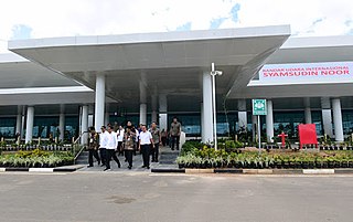
Syamsudin Noor International Airport is an international airport serving Banjarmasin in South Kalimantan of Indonesia. It is located in the district of Landasan Ulin, 5 kilometres west of Banjarbaru, capital of South Kalimantan and about 25 km south-east from the centre of the city of Banjarmasin, the largest city of South Kalimantan. The airport served more than 5.3 million passengers in 2017.

Ma'anyan, Dayak Maanyan or Eastern Barito Dayak people are a sub-ethnic group of the Dayak people indigenous to Borneo. They are also considered as part of the east Barito Dusun group with the name Dusun Ma'anyan. According to J. Mallinckrodt (1927), the Dusun people group is part of the Ot Danum people cluster, although later that theory was disproved by A. B. Hudson (1967), who argues that the Ma'anyan people are a branch of the Barito family. The Ma'anyan people who are often referred to as Dayak people are also referred to as Dayak Ma'anyan. The Dayak Ma'anyan people inhabit the east side of Central Kalimantan, especially in the East Barito Regency and parts of South Barito Regency which are grouped as Ma'anyan I. The Dayak Ma'anyan people also inhabit the northern parts of South Kalimantan, especially in Tabalong Regency which refers to the Dayak Warukin people. The Dayak Balangan people or Dusun Balangan people which are found in the Balangan Regency and the Dayak Samihim people that are found in the Kotabaru Regency are grouped together with the Dayak Ma'anyan people group. The Dayak Ma'anyan people in South Kalimantan are grouped as Ma'anyan II.
Lawangan or Luangan people are a sub-ethnic of the Dayak Dusun people group, sometimes also referred to as Dusun Lawangan or Dayak Lawangan. The Lawangan people inhabit the eastern side of Central Kalimantan and West Kutai Regency, East Kalimantan, Indonesia. In Tabalong Regency, South Kalimantan, the Lawangan people can be found only in Binjai village. They speak Lawangan language.
Bakumpai or Baraki are indigenous people of Borneo and are considered as a sub-ethnic group of the Dayak Ngaju people group with Islamic background. The Bakumpai people first occupy along the Barito riverbanks in South Kalimantan and Central Kalimantan, from Marabahan to Puruk Cahu, Murung Raya Regency. The Bakumpai people first appeared as a newly recognized people group in census 2000 and were made up of 7.51% of Central Kalimantan population, which before this the Bakumpai people were considered as part of the Dayak people in a 1930 census.
The Negara River is a river of Borneo, Indonesia. It flows in the southeast region of the island, within the Negara District, province of South Kalimantan. It is the second longest river in the province after the Barito River, which the Negara River flows into.

Tanjung Selor is the capital of both the North Kalimantan province in Indonesia, and of the Bulungan Regency. It is among provincial capitals in Indonesia that as of 2021 does not yet have city status, together with Mamuju in West Sulawesi, Sofifi in North Maluku, Nabire in Central Papua, Wamena in Highland Papua, Merauke in South Papua, and Manokwari in West Papua. The district has an area of 677.77 km2 and had a population of 39,439 at the 2010 Census and 56,569 at the 2020 Census.
Dusun Deyah, or Deyah, is a language spoken by a group of Dusun people of South Kalimantan province, Indonesia. It is spoken in Tabalong Regency across two districts: Haruai, in the villages of Kinarum, Kaong, Pangelak, and Bilas, and Muara Uya, especially in the village of Mangkopom.

Batu Licin, also written as Batulicin, is a district of Tanah Bumbu regency and its capital, in South Kalimantan, Indonesia. Batulicin is situated on the banks of the Batulicin River and is 265 km east of the city of Banjarmasin, capital of the province in South Kalimantan.
PT Adaro Energy Indonesia Tbk is an Indonesian second-largest coal miner by production volume and its largest by market capitalisation. In the 2011 Forbes Global 2000, Adaro Energy was ranked as the 1527th -largest public company in the world. The company is an Indonesian energy group that focuses on coal mining through subsidiaries. The principal location is at Tabalong district in South Kalimantan, where the subsidiary PT Adaro Indonesia operates the largest single-site coal mine in the southern hemisphere. Adaro Energy operates under a first-generation CCA with the Indonesian Government valid until 2022.

Tanjung Bara Coal Terminal, abbreviated as TBCT, or commonly known as Tanjung Bara, is a coal loading port in Indonesia. Primarily known for its coal loading terminal, it lies on the southeast coast of East Kalimantan, Borneo.
This is a list of emblems or coat of arms used in Indonesia. Indonesia is divided into 38 provinces, and each province is divided into regencies (kabupaten) and cities (kota). There are 416 regencies and 98 cities. Each province, regency, and city has its own emblem.


