Tempo (bus rapid transit)

Last updated
Tempo
Tempo AC Transit logo.svg
Southbound bus at Downtown San Leandro station, August 2020.JPG
A southbound bus at Downtown San Leandro station
Overview
Operator AC Transit
GarageDivision 4
Vehicle27 New Flyer XDE60 [1]
Began serviceAugust 9, 2020 (2020-08-09)
Predecessors1, 1R
Route
Locale Oakland, San Leandro
Start Uptown Transit Center
Via International Boulevard
End San Leandro BART station
Length9.5 mi (15.3 km)
Stations34
Service
Frequency10 min (6 am–7 pm)
15 min (7 pm–midnight)
30–60 min (midnight–6 am)
Journey time40–47 min
Ridership1,027,280 (2020)
Timetable AC Transit Tempo
Map AC Transit Tempo
Route map
Tempo (bus rapid transit)
BSicon utdCONTg.svg
BSicon HUBaq.svg
BSicon utINT.svg
BSicon ldINT.svg
BSicon HUBeq.svg
BSicon dKBHFa.svg
Uptown Transit Center
Bart-logo.svg
BSicon HUBaq.svg
BSicon utBHF.svg
BSicon ldINT.svg
BSicon HUBeq.svg
BSicon dSTR.svg
14th Street
Bart-logo.svg
BSicon ucCONTgq.svg
BSicon utSTR+r.svg
BSicon utv-STRr.svg
BSicon utSHI1+l.svg
BSicon SPLa.svg
BSicon utSTR.svg
BSicon vBHF(R)f-BHF(L)g.svg
City Center
BSicon utSTR.svg
BSicon vBHF(R)f-BHF(L)g.svg
Harrison Street
BSicon utSTR.svg
BSicon vBHF(R)f-BHF(L)g.svg
Madison Street
BSicon utHST.svg
BSicon SPLe.svg
BSicon utSTR.svg
BSicon SPLa.svg
BSicon utSTR.svg
BSicon vBHF(R)f-BHF(L)g.svg
2nd Avenue
BSicon utSTRe.svg
BSicon vBHF(R)f-BHF(L)g.svg
5th Avenue
BSicon uSTR.svg
BSicon vBHF(R)f-BHF(L)g.svg
10th Avenue
BSicon uSTR.svg
BSicon vBHF(R)f-BHF(L)g.svg
14th Avenue
BSicon uhSTRa.svg
BSicon SPLe.svg
BSicon uhSTR.svg
BSicon BHF.svg
20th Avenue
BSicon uhSTR.svg
BSicon BHF.svg
24th Avenue
BSicon uhSTR.svg
BSicon BHF.svg
28th Avenue
BSicon uhSTR.svg
BSicon BHF.svg
31st Avenue
BSicon HUBaq.svg
BSicon uhBHF.svg
BSicon HUBeq.svg
BSicon INT.svg
Fruitvale
Bart-logo.svg
BSicon uhSTR.svg
BSicon BHF.svg
39th Avenue
BSicon uhSTR.svg
BSicon BHF.svg
High Street
BSicon uLLSTR3.svg
BSicon MFADEf.svg
BSicon lhSTR3.svg
BSicon BHF.svg
48th Avenue
BSicon BHF.svg
54th Avenue
BSicon BHF.svg
Seminary Avenue
BSicon KDSTaq.svg
BSicon TEEeq.svg
Division 4
BSicon BHF.svg
63rd Avenue
BSicon BHF.svg
67th Avenue
BSicon BHF.svg
73rd Avenue
BSicon BHF.svg
77th Avenue
BSicon BHF.svg
82nd Avenue
BSicon BHF.svg
86th Avenue
BSicon BHF.svg
90th Avenue
BSicon BHF.svg
95th Avenue
BSicon BHF.svg
98th Avenue
BSicon BHF.svg
103rd Avenue
BSicon BHF.svg
Durant Avenue
BSicon STR+GRZq.svg
BSicon HST.svg
Georgia Way
BSicon HST.svg
San Leandro Civic Center
BSicon uLLSTR+4.svg
BSicon MFADEg.svg
BSicon lhSTR+4.svg
BSicon HST.svg
Downtown San Leandro
BSicon uhBHF.svg
BSicon KBHFaq.svg
BSicon STRr.svg
San Leandro BART
Bart-logo.svg
BSicon uhCONTf.svg

Wheelchair symbol.svg All stations are accessible
   List of AC Transit routes   6  

Tempo is a bus rapid transit (BRT) service in Oakland and San Leandro in California. It is operated by AC Transit as Line 1T. The route has dedicated lanes and center-boarding stations along much of the corridor, prepaid fares, signal preemption, and all-door boarding.

Contents

Route

The northern terminus of the line is at the Uptown Transit Center, located at the 19th Street/Oakland BART station. The lines continues down Broadway in mixed traffic, passing 12th Street/Oakland City Center BART station before the southbound and northbound routes split at 11th and 12th Streets, respectively. Both directions simultaneously meet at and run on Lake Merritt Boulevard before splitting again to 12th Street and International Boulevard. Southbound buses join International Boulevard at 14th Avenue and begin median running in an exclusive bus lane. Services continue to a station near Fruitvale BART and onward to San Leandro, where operation in mixed traffic resumes and the line continues down Davis Street to terminate at San Leandro BART.

Articulated buses call at specially built high-curbed bus stops at the north and south ends of the line while the majority of International Boulevard stops feature median strip boarding platforms.

History

Planning

A 1993 AC Transit study designed the Berkeley–Oakland–San Leandro corridor as a potential alignment for major transit investment. [2] :1.19 The agency began work on a Major Investment Study (MIS) for the corridor in 1999. Telegraph Avenue was selected as the Berkeley–Oakland alignment in 2011; Shattuck Avenue had lower expected ridership, while College Avenue had fewer opportunities for transit-oriented development. [3] :8 The 2002-released MIS recommended bus rapid transit (BRT) for the corridor; light rail was deemed not to be cost-effective, while enhancements to conventional bus service would not generate significant ridership increases. [2] :S2

A route 1R bus in Oakland in 2012 AC Transit 2160.JPG
A route 1R bus in Oakland in 2012

Prior to 2007, Telegraph Avenue was primarily served by the 40/40L local/limited-stop routes, while International Boulevard and East 14th Street were served by the 82/82L pair. Service changes on June 24, 2007, included the establishment of Berkeley–Downtown Oakland–Bay Fair routes 1R and 1; the 82/82L were discontinued and the 40/40L were cut back to no longer serve Telegraph Avenue. [4] :2.3 [5] [6] Route 1R (the International Rapid) operated as a limited-stop overlay of local route 1; it had some bus rapid transit features like transit signal priority and wide stop spacing, but not all-door boarding or dedicated lanes. It was intended as a first phase while the full BRT service was planned. [3] :8,16

The 2007 Draft Environmental Impact Statement/Environmental Impact Report considered whether to have Bay Fair or San Leandro as the southern terminus, and whether to have separate local and express services or a single combined service. [2] :S1 AC Transit later selected a combined service to San Leandro station as the Locally Preferred Alternative. [7] In April 2010, the Berkeley City Council voted against the inclusion of center bus lanes over concerns about reducing Telegraph Avenue to a single general traffic lane in each direction. The city's preferred alternative, with curbside stops and no dedicated bus lanes, was not compatible with BRT service standards. Berkeley withdrew from the project in 2011. [8] [9] San Leandro also objected to center lanes on its portion of the line. [10]

The Final Environmental Impact Statement/Final Environmental Impact Report, released in January 2012, removed the center lanes south of Georgia Way in San Leandro. It also included a Downtown Oakland–San Leandro alternative to allow the project to proceed without the Berkeley and North Oakland section. AC Transit approved this shorter alternative in April 2012, followed by the Oakland and San Leandro city councils that July. [8] [11] (That June, the center lanes had been further cut to Broadmoor Street near the Oakland/San Leandro border by the San Leandro city council. [8] )

Construction and service

The southbound BRT platform at 19th Street under construction in April 2020 Southbound BRT platform at 19th Street under construction, April 2020.jpg
The southbound BRT platform at 19th Street under construction in April 2020

Route 1R was eliminated on June 26, 2016 to allow for construction. Route 1 was changed to run only between Downtown Oakland and San Leandro station; new routes 6 and 10 were created to serve the Downtown Oakland–Berkeley and San Leandro–Bay Fair segments. [12] Groundbreaking was held in August 2016. [13] The project was funded by a mix of local, state, and federal funds; major sources included Federal Transit Administration Small Starts (31%), Regional Measure 2 bridge tolls (24%), AC Transit (10%), and Alameda County Measure B/Measure BB sales tax (9.2%). [14]

The service was branded Tempo in July 2020, with the service numbered 1T. [15] Route 1T service began on August 9, 2020, with local route 1 eliminated. [16] Tempo was fare-free for the first 90 days of service; fare collection started on November 9, 2020. [17] The total cost of the project was $232 million. [16]

On March 31, 2023, overnight service was curtailed to City Center (northbound) and 14th Street (southbound) due to street closures in downtown Oakland. [18] On August 6 of the same year, late-night trips (after 9 pm) were also truncated in the same way. [19]

A 2016 AC Transit study of potential improvements to major corridors proposed extensions of the Downtown Oakland–San Leandro corridor to Emeryville via West Grand Avenue, and to Bay Fair station via East 14th Street. [20]

Related Research Articles

<span class="mw-page-title-main">Alameda County, California</span> County in California, United States

Alameda County is a county located in the U.S. state of California. As of the 2020 census, the population was 1,682,353, making it the 7th-most populous county in the state and 21st most populous nationally. The county seat is Oakland. Alameda County is in the San Francisco Bay Area, occupying much of the East Bay region.

<span class="mw-page-title-main">AC Transit</span> Public transit operator in Alameda County and Contra Costa County, California

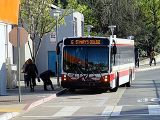
AC Transit is an Oakland-based public transit agency serving the western portions of Alameda and Contra Costa counties in the East Bay of the San Francisco Bay Area. AC Transit also operates "Transbay" routes across San Francisco Bay to San Francisco and selected areas in San Mateo and Santa Clara counties. AC Transit is constituted as a special district under California law. It is governed by seven elected members. It is not a part of or under the control of Alameda or Contra Costa counties or any local jurisdictions.

<span class="mw-page-title-main">County Connection</span> Public transit agency in Contra Costa County, California

The County Connection is a Concord-based public transit agency operating fixed-route bus and ADA paratransit service in and around central Contra Costa County in the San Francisco Bay Area. Established in 1980 as a joint powers authority, CCCTA assumed control of public bus service within central Contra Costa first begun by Oakland-based AC Transit as it expanded into suburban Contra Costa County in the mid-1970s. In 2023, the system had a ridership of 2,661,400, or about 9,900 per weekday as of the fourth quarter of 2023.

<span class="mw-page-title-main">California State Route 123</span> Highway in California

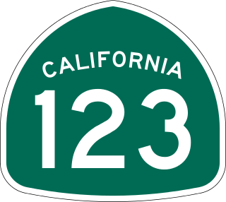
State Route 123 is a 7.39-mile (11.89 km) state highway in the U.S. state of California in the San Francisco Bay Area. Named San Pablo Avenue for almost its entire length except for its northernmost 0.10 miles (0.16 km), SR 123 is a major north–south state highway along the flats of the urban East Bay. Route 123 runs between Interstate 580 in Oakland in the south and Interstate 80 at Cutting Boulevard in Richmond in the north. San Pablo Avenue itself, a portion of Historic US 40, continues well past the SR 123 designation south to Downtown Oakland and north to Crockett.

<span class="mw-page-title-main">East Bay</span> Eastern region of the San Francisco Bay Area, California, US

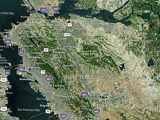
The East Bay is the eastern region of the San Francisco Bay Area and includes cities along the eastern shores of the San Francisco Bay and San Pablo Bay. The region has grown to include inland communities in Alameda and Contra Costa counties. With a population of roughly 2.5 million in 2010, it is the most populous subregion in the Bay Area.

<span class="mw-page-title-main">12th Street Oakland City Center station</span> Rapid transit station in Oakland, California, US

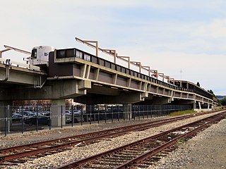
12th Street/Oakland City Center station is an underground Bay Area Rapid Transit (BART) station located under Broadway between 12th Street and 14th Street in Downtown Oakland, adjacent to the Oakland City Center. It is the second-busiest BART station in both Oakland and the East Bay, and the 6th busiest BART station overall, with a daily ridership of approximately 5,000 in September 2023.

<span class="mw-page-title-main">19th Street Oakland station</span> Metro station in Oakland, California, US

19th Street Oakland station is an underground Bay Area Rapid Transit (BART) station located under Broadway between 17th Street and 20th Street in the Uptown District of Oakland, California. It is a timed transfer point between northbound trains to Richmond and to Antioch. It is the busiest BART station in both Oakland and the East Bay, and the 5th busiest BART station overall, with a daily ridership of approximately 4,700 in September 2023.

<span class="mw-page-title-main">Richmond station (California)</span> Railway station in Richmond, California, US

Richmond station is an Amtrak intercity rail and Bay Area Rapid Transit (BART) station located in downtown Richmond, California. Richmond is the north terminus of BART service on the Orange Line and Red Line; it is a stop for Amtrak's Capitol Corridor, San Joaquins, and California Zephyr routes. The accessible station has one island platform for the two BART tracks, with a second island platform serving two of the three tracks of the Union Pacific Railroad Martinez Subdivision for Amtrak trains. It is one of two transfer points between BART and Amtrak, along with Oakland Coliseum station.

<span class="mw-page-title-main">Downtown Berkeley station</span> Metro station in Berkeley, California, US

Downtown Berkeley station is an underground Bay Area Rapid Transit (BART) station in the Downtown Berkeley section of Berkeley, California. It is served by the Orange Line and Red Line.

<span class="mw-page-title-main">Hayward station (BART)</span> Metro station in Hayward, California, US

Hayward station is a Bay Area Rapid Transit (BART) station in Hayward, California, serving Downtown Hayward and the surrounding areas. The station opened on September 11, 1972. It is served by the Orange Line and Green Line.

<span class="mw-page-title-main">Transportation in the San Francisco Bay Area</span> Overview of transportation in the San Francisco Bay Area, California, United States

People in the San Francisco Bay Area rely on a complex multimodal transportation infrastructure consisting of roads, bridges, highways, rail, tunnels, airports, seaports, and bike and pedestrian paths. The development, maintenance, and operation of these different modes of transportation are overseen by various agencies, including the California Department of Transportation (Caltrans), the Association of Bay Area Governments, San Francisco Municipal Transportation Agency, and the Metropolitan Transportation Commission. These and other organizations collectively manage several interstate highways and state routes, eight passenger rail networks, eight trans-bay bridges, transbay ferry service, local and transbay bus service, three international airports, and an extensive network of roads, tunnels, and bike paths.

<span class="mw-page-title-main">All Nighter (bus service)</span> San Francisco Bay Area late night bus service

The All Nighter is a night bus service network in the San Francisco Bay Area, California. Portions of the service shadow the rapid transit and commuter rail services of BART and Caltrain, which are the major rail services between San Francisco, the East Bay, the Peninsula, and San Jose. Neither BART nor Caltrain operate owl service due to overnight track maintenance; the All Nighter network helps fill in this service gap. The slogan is, "Now transit stays up as late as you do!"

<span class="mw-page-title-main">Oakland Coliseum station</span> Rail station in Oakland, California, US

The station complex of Amtrak's Oakland Coliseum station and Bay Area Rapid Transit (BART)'s Coliseum station is located in the East Oakland area of Oakland, California, United States. The two stations, located about 600 feet (180 m) apart, are connected to each other and to the Oakland Coliseum/Oakland Arena sports complex with an accessible pedestrian bridge. The BART station is served by the Orange, Green Line, and Blue lines; the Amtrak station is served by the Capitol Corridor service.

<span class="mw-page-title-main">Richmond Heights, Richmond, California</span> Place in Richmond, California, United States of America

Richmond Heights, formerly East Richmond and also known as Mira Vista, is a district of eastern Richmond, California, in the San Francisco Bay Area.

<span class="mw-page-title-main">Downtown Oakland</span> Central business district of Oakland, California

Downtown Oakland is the central business district of Oakland, California, United States. It is located roughly bounded by both the Oakland Estuary and Interstate 880 on the southwest, Interstate 980 on the northwest, Grand Avenue on the northeast, and Lake Merritt on the east.

International Boulevard, East 14th Street, and Mission Boulevard is a major road in Alameda County, California. The section now known as International Boulevard was also named East 14th Street until 1996, owing to its position in the East Oakland grid plan; though fully deprecated within the city of Oakland today, this name is still commonly used, especially in casual speech. Mission Boulevard is so named as number 43300 is the location of Mission San José.

<span class="mw-page-title-main">Geary Bus Rapid Transit</span> Bus rapid transit project in San Francisco

The Geary Bus Rapid Transit project added bus rapid transit features to San Francisco Municipal Railway bus lines along Geary Boulevard. The corridor serves routes 38, 38R, 38AX, 38BX which combined to serve 52,900 daily riders in 2019, the most of any corridor in the city. The project added transit-only lanes, painted red, along many sections of Geary between the Transbay Transit Center and 33rd Avenue. After the project’s completion, over 75% of Geary corridor now has transit lanes.

<span class="mw-page-title-main">Van Ness Bus Rapid Transit</span> Bus rapid transit corridor in San Francisco

Van Ness Bus Rapid Transit is a bus rapid transit (BRT) corridor on Van Ness Avenue in San Francisco, California, United States. The 1.96-mile (3.15 km) line, which runs between Mission Street and Lombard Street, has dedicated center bus lanes and nine stations. It was built as part of the $346 million Van Ness Improvement Project, which also included utility replacement and pedestrian safety features. Van Ness Bus Rapid Transit is used by several San Francisco Municipal Railway (Muni) lines including the 49 Van Ness–Mission, as well as three Golden Gate Transit routes.

<span class="mw-page-title-main">AC Transit Route 72</span> Bus service in California

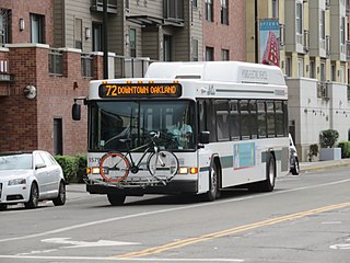
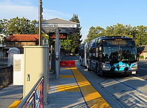
The 72 is a bus route in the East Bay operated by AC Transit. It serves the San Pablo Avenue corridor between Jack London Square in Oakland and Hilltop Mall in Richmond. The service is descendant from the original streetcar lines that ran along the street.

References

  1. Almond, Elliot (9 August 2020). "AC Transit rolls out new service linking Oakland and San Leandro". The Mercury News. Retrieved 10 August 2020.
  2. 1 2 3 Federal Transit Administration; Alameda Contra Costa Transit District (May 2007). AC Transit East Bay Bus Rapid Transit Project Draft Environmental Impact Statement/ Environmental Impact Report (PDF).
  3. 1 2 Martin, Ajay; Perkins Haslam, Angie; LaVigne, Cory (February 9, 2011). "Line 1R Service and Reliability Study Final Report" (PDF). AC Transit Service and Operations Planning.
  4. Nelson\Nygaard Consulting Associates (March 2008). "International/Telegraph Corridor Rapid Bus Study: Phase III" (PDF). Alameda-Contra Costa Transit District.
  5. "Change Happens: June 24" (Press release). Alameda Contra Costa Transit District. May 15, 2007. Archived from the original on November 1, 2007.
  6. "AC Transit Service Changes: San Pablo to Hayward—Effective June 24, 2007". Alameda Contra Costa Transit District. May 15, 2007. Archived from the original on November 3, 2007.
  7. Federal Transit Administration; Alameda Contra Costa Transit District (January 2012). "Summary" (PDF). AC Transit East Bay BRT Project: Final Environmental Impact Statement/ Environmental Impact Report. p. S.1-1.
  8. 1 2 3 J. Douglas Allen-Taylor (July 19, 2012). "BRT Coming to East Oakland". East Bay Express.
  9. Swan, Rachel (March 4, 2019). "East Oakland, despite resistance, edging out SF in building bus rapid transit". San Francisco Chronicle.
  10. J. Douglas Allen-Taylor (February 2, 2011). "What's left of BRT?". East Bay Express.
  11. "San Leandro City Council Approves Bus Rapid Transit" (Press release). Alameda Contra Costa Transit District. July 16, 2012.
  12. "Service changes effective Sunday, June 26" (Press release). Alameda-Contra Costa Transit District. June 15, 2016.
  13. "AC TRANSIT ANNOUNCES THE GROUNDBREAKING CEREMONY FOR THE EAST BAY BUS RAPID TRANSIT" (Press release). Alameda-Contra Costa Transit District. August 26, 2016.
  14. "BRT Funding". Alameda-Contra Costa Transit District.
  15. "Meet AC Transit Tempo" (Press release). Alameda-Contra Costa Transit District. July 14, 2020.
  16. 1 2 "AC TRANSIT TEMPO OPENS TO RIDERS SUNDAY, AUGUST 9" (Press release). Alameda-Contra Costa Transit District. August 7, 2020.
  17. "Tempo Line 1T Fares Start November 9" (Press release). Alameda-Contra Costa Transit District. October 28, 2020.
  18. "New: Nighttime Downtown Oakland Service Disruptions and Changes". Alameda-Contra Costa Transit District. March 27, 2023.
  19. "Service Changes Effective Sunday, August 6". Alameda-Contra Costa Transit District. July 13, 2023.
  20. "Major Corridors Study Final Report" (PDF). Alameda-Contra Costa Transit District. July 15, 2016. p. 54.
Template:Attached KML/Tempo (bus rapid transit)
KML is from Wikidata

Commons-logo.svg Media related to Tempo (bus rapid transit) at Wikimedia Commons