Related Research Articles

Geodesy is the science of measuring and representing the geometry, gravity, and spatial orientation of the Earth in temporally varying 3D. It is called planetary geodesy when studying other astronomical bodies, such as planets or circumplanetary systems.

Geophysics is a subject of natural science concerned with the physical processes and physical properties of the Earth and its surrounding space environment, and the use of quantitative methods for their analysis. Geophysicists, who usually study geophysics, physics, or one of the Earth sciences at the graduate level, complete investigations across a wide range of scientific disciplines. The term geophysics classically refers to solid earth applications: Earth's shape; its gravitational, magnetic fields, and electromagnetic fields ; its internal structure and composition; its dynamics and their surface expression in plate tectonics, the generation of magmas, volcanism and rock formation. However, modern geophysics organizations and pure scientists use a broader definition that includes the water cycle including snow and ice; fluid dynamics of the oceans and the atmosphere; electricity and magnetism in the ionosphere and magnetosphere and solar-terrestrial physics; and analogous problems associated with the Moon and other planets.
The geoid is the shape that the ocean surface would take under the influence of the gravity of Earth, including gravitational attraction and Earth's rotation, if other influences such as winds and tides were absent. This surface is extended through the continents. According to Gauss, who first described it, it is the "mathematical figure of the Earth", a smooth but irregular surface whose shape results from the uneven distribution of mass within and on the surface of Earth. It can be known only through extensive gravitational measurements and calculations. Despite being an important concept for almost 200 years in the history of geodesy and geophysics, it has been defined to high precision only since advances in satellite geodesy in the late 20th century.
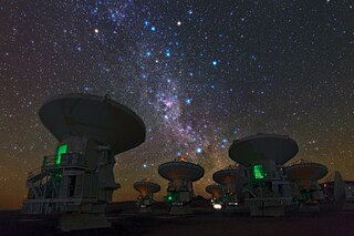
Very-long-baseline interferometry (VLBI) is a type of astronomical interferometry used in radio astronomy. In VLBI a signal from an astronomical radio source, such as a quasar, is collected at multiple radio telescopes on Earth or in space. The distance between the radio telescopes is then calculated using the time difference between the arrivals of the radio signal at different telescopes. This allows observations of an object that are made simultaneously by many radio telescopes to be combined, emulating a telescope with a size equal to the maximum separation between the telescopes.
The Chandler wobble or Chandler variation of latitude is a small deviation in the Earth's axis of rotation relative to the solid earth, which was discovered by and named after American astronomer Seth Carlo Chandler in 1891. It amounts to change of about 9 metres (30 ft) in the point at which the axis intersects the Earth's surface and has a period of 433 days. This wobble, which is an astronomical nutation, combines with another wobble with a period of one year, so that the total polar motion varies with a period of about 7 years.

In satellite laser ranging (SLR) a global network of observation stations measures the round trip time of flight of ultrashort pulses of light to satellites equipped with retroreflectors. This provides instantaneous range measurements of millimeter level precision which can be accumulated to provide accurate measurement of orbits and a host of important scientific data. The laser pulse can also be reflected by the surface of a satellite without a retroreflector, which is used for tracking space debris.

The International Terrestrial Reference System (ITRS) describes procedures for creating reference frames suitable for use with measurements on or near the Earth's surface. This is done in much the same way that a physical standard might be described as a set of procedures for creating a realization of that standard. The ITRS defines a geocentric system of coordinates using the SI system of measurement.
Satellite geodesy is geodesy by means of artificial satellites—the measurement of the form and dimensions of Earth, the location of objects on its surface and the figure of the Earth's gravity field by means of artificial satellite techniques. It belongs to the broader field of space geodesy. Traditional astronomical geodesy is not commonly considered a part of satellite geodesy, although there is considerable overlap between the techniques.

Polar motion of the Earth is the motion of the Earth's rotational axis relative to its crust. This is measured with respect to a reference frame in which the solid Earth is fixed. This variation is a few meters on the surface of the Earth.
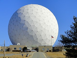
Haystack Observatory is a multidisciplinary radio science center, ionospheric observatory, and astronomical microwave observatory owned by Massachusetts Institute of Technology (MIT). It is in Westford, Massachusetts, in the United States, about 45 kilometers (28 mi) northwest of Boston. The observatory was built by MIT's Lincoln Laboratory for the United States Air Force and was called the Haystack Microwave Research Facility. Construction began in 1960, and the antenna began operating in 1964. In 1970 the facility was transferred to MIT, which then formed the Northeast Radio Observatory Corporation (NEROC) with other universities to operate the site as the Haystack Observatory. As of January 2012, a total of nine institutions participated in NEROC.
The Journal of Geophysical Research is a peer-reviewed scientific journal. It is the flagship journal of the American Geophysical Union. It contains original research on the physical, chemical, and biological processes that contribute to the understanding of the Earth, Sun, and Solar System. It has seven sections: A, B, C (Oceans), D (Atmospheres), E (Planets), F, and G (Biogeosciences). All current and back issues are available online for subscribers.
The International Union of Geodesy and Geophysics is an international non-governmental organization dedicated to the scientific study of Earth and its space environment using geophysical and geodetic techniques.
In geodesy and astrometry, earth orientation parameters (EOP) describe irregularities in the rotation of planet Earth. EOP provide the rotational transform from the International Terrestrial Reference System (ITRS) to the International Celestial Reference System (ICRS), or vice versa, as a function of time.
William M. Kaula was an Australian-born American geophysicist and professor at the University of California, Los Angeles. Kaula was most notable for his contributions to geodesy, including using early satellites to produce maps of Earth's gravity. The National Academies Press called Kaula "the father of space-based geodesy". The Los Angeles Times called him "one of the leading planetary physicists of the last four decades".

The Lwandle Plate is one of three tectonic microplates, along with the Rovuma Plate and Victoria Plate, that make up the African Plate with the Somali Plate and the Nubian Plate. Its discovery is very recent, so the velocity of the plate is neither well known nor well understood. Many experiments are ongoing to quantify this. The Lwandle Plate lies between 30°E and 50°E, sharing a boundary with the Nubian, Somali, and Antarctic Plates.
Seth Avram Stein is an American geophysicist with an international reputation for his research in plate tectonics, seismology, and space geodesy. He has also done important work in public policy for coping with earthquake hazards.
Richard G. Gordon is an American geophysicist, known for his research on global tectonics, including global plate motions and palaeomagnetism. He is noteworthy for leading two global plate motion projects: NUVEL and MORVEL. In the geosciences, NUVEL and MORVEL are standard models for global plate motions.
Tonie Marie van Dam is an American geophysicist and geodesist, known for her pioneering research on solid Earth deformations due to loads from atmospheric and hydrologic pressures. She and her collaborators used space geodetic observations and modeling for increased precision in measuring and understanding such loads.
John Matthew Wahr was an American geophysicist and geodesist, known for his research on Earth's rotation, Earth tides, ocean tides, post-glacial rebound, and other topics in the geosciences.
Susanna Zerbini is an Italian geophysicist, geodesist, and geodynamicist. She is known as a pioneer in developing and applying satellite geodesy for research in geodynamics and Earth system sciences.
References
- ↑ "Thomas Herring, Professor of Geophysics". MIT EAPS Directory, Earth, Atmospheric and Planetary Sciences (EAPS), Massachusetts Institute of Technology (MIT).
- 1 2 3 4 5 6 7 8 "Vening Meinesz Medal / 2007 / Thomas Herring". European Geosciences Union.
- ↑ Herring, T.A. (1999). "Geodetic applications of GPS". Proceedings of the IEEE. 87: 92–110. doi:10.1109/5.736344.
- 1 2 3 4 5 6 "Curriculum Vitae: Thomas A. Herring". mit.edu.
- ↑ Herring, T. (Thomas) (1983). The precision and accuracy of intercontinental distance determinations using radio interferometry. MIT Libraries (Thesis). hdl:1721.1/15543.
- ↑ Shapiro ,I. I.; Counselman ,C. C.; Herring,T. A. (1979-08-10). "Analysis of Laser Ranging and VLBI Observations for Geodetic Purposes, Accession Number: ADA077294, Defense Technical Information Center".
- ↑ Herring, T. A. (1986). "Precision of vertical position estimates from Very Long Baseline Interferometry". Journal of Geophysical Research: Solid Earth. 91 (B9): 9177–9182. Bibcode:1986JGR....91.9177H. doi:10.1029/JB091iB09p09177.
- ↑ Herring, Thomas A. (1995). "VLBI data, acquisition, environmental effects". Reviews of Geophysics. 33 (S1): 345–348. Bibcode:1995RvGeo..33S.345H. doi:10.1029/95RG00349. hdl: 2060/19960011396 .
- ↑ Mathews, P. M.; Buffett, B. A.; Herring, T. A.; Shapiro, I. I. (1991). "Forced nutations of the Earth: Influence of inner core dynamics: 1. Theory". Journal of Geophysical Research: Solid Earth. 96 (B5): 8219–8242. Bibcode:1991JGR....96.8219M. doi:10.1029/90JB01955.
- ↑ Mathews, P. M.; Buffett, B. A.; Herring, T. A.; Shapiro, I. I. (1991). "Forced nutations of the Earth: Influence of inner core dynamics: 2. Numerical results and comparisons". Journal of Geophysical Research: Solid Earth. 96 (B5): 8243–8257. Bibcode:1991JGR....96.8243M. doi:10.1029/90JB01956.
- ↑ Rosat, Séverine; Bizouard, Christian; Nurul Huda, Ibnu; Lambert, Sébastien B.; Ziegler, Yann (2020). "Contribution of a joint Bayesian inversion of VLBI and gravimetric data to the estimation of the free inner core nutation and free core nutation resonance parameters". Geophysical Journal International. 222 (2): 845–860. doi:10.1093/gji/ggaa181.
- ↑ Mathews, P. M.; Herring, T. A.; Buffett, B. A. (2002). "Modeling of nutation and precession: New nutation series for nonrigid Earth and insights into the Earth's interior". Journal of Geophysical Research: Solid Earth. 107 (B4): 2068. Bibcode:2002JGRB..107.2068M. doi: 10.1029/2001JB000390 .
- ↑ Herring, Thomas A. (1991). "The Rotation of the Earth". Reviews of Geophysics. 29: 172–175. doi:10.1002/rog.1991.29.s1.172.
- ↑ "Herring, Thomas | MIT Department of Earth, Atmospheric and Planetary Sciences".
- ↑ "Thomas A. Herring | Southern California Earthquake Center".
- ↑ Feigl, Kurt L.; Agnew, Duncan C.; Bock, Yehuda; Dong, Danan; Donnellan, Andrea; Hager, Bradford H.; Herring, Thomas A.; Jackson, David D.; Jordan, Thomas H.; King, Robert W.; Larsen, Shawn; Larson, Kristine M.; Murray, Mark H.; Shen, Zhengkang; Webb, Frank H. (1993). "Space geodetic measurement of crustal deformation in central and southern California, 1984–1992". Journal of Geophysical Research: Solid Earth. 98 (B12): 21677–21712. Bibcode:1993JGR....9821677F. doi:10.1029/93JB02405.
- ↑ Shen, Z.-K.; King, R. W.; Agnew, D. C.; Wang, M.; Herring, T. A.; Dong, D.; Fang, P. (2011). "A unified analysis of crustal motion in Southern California, 1970-2004: The SCEC crustal motion map". Journal of Geophysical Research: Solid Earth. 116 (B11). Bibcode:2011JGRB..11611402S. doi:10.1029/2011JB008549. hdl: 1721.1/85589 .
- ↑ "Prof. Thomas A. Herring". MIT Industrial Liaison Program (ILP).
- ↑ "User Profile: Dr. Thomas A. Herring | Earthdata". 22 December 2020.
- ↑ "Professor of Geophysics Thomas A. Herring on how he studies Earth's surface". News, MIT Department of Earth, Atmospheric and Planetary Sciences, MIT. January 8, 2021.
- ↑ Herring, T. A.; King, R. W.; McClusky, S. C. (2008). "Introduction to GAMIT/GLOBK". Massachusetts Institute of Technology.
- ↑ "GAMIT/GLOBK homepage". Massachusetts Institute of Technology.
- ↑ Herring, Thomas A.; Davis, James L.; Shapiro, Irwin I. (1990). "Geodesy by radio interferometry: The application of Kalman Filtering to the analysis of very long baseline interferometry data". Journal of Geophysical Research: Solid Earth. 95 (B8): 12561–12581. Bibcode:1990JGR....9512561H. doi:10.1029/JB095iB08p12561.
- ↑ Floyd, M. A.; Herring, T. A.; King, R. W.; McClusky, S. C. (2022). "GAMIT/GLOBK Quick Start Guide" (PDF). Massachusetts Institute of Technology.
- ↑ "Thomas Herring". American Geophysical Union (AGU).
- ↑ Herring, T. A. (1996). "Bomford Prize acceptance". Journal of Geodesy. 70 (12): 878–879. Bibcode:1996JGeod..70..878H. doi:10.1007/BF00873763. S2CID 121407330.
- ↑ "Historic Fellows". American Association for the Advancement of Science (AAAS). (Search on name=Herring & institution=Massachusetts Institute of Technology.)
| International | |
|---|---|
| National | |
| Academics | |
| Other | |