Titnore Wood

Last updated

Titnore Wood
Titnore Lane - geograph.org.uk - 1333857.jpg
Titnore Wood extends east of Titnore Lane in the north-west of Worthing
Geography
Location West Sussex, England
Ecology
Dominant tree species Oak, ash, silver birch, field maple, hazel and common hawthorn
Fauna Mole, shrew, dormouse, bank vole, woodmouse, grey squirrel, weasel, fox

Titnore Wood is an area of ancient woodland to the north-west of Worthing in West Sussex. With neighbouring Goring Wood it forms one of the last remaining blocks of ancient woodland on the West Sussex coastal plain.

Contents

Since 2006 land in and around the wood has been the site of a proposed major urban extension to the Worthing suburb of West Durrington. The proposed development has prompted environmental protestors to tree-sit within the wood since May 2006. [1] Since then Worthing Borough Council has agreed to a substantial new housing development just to the east of the woods themselves, as an extension of Durrington. This includes a new school, doctors surgery and around 2000 new houses on agricultural land.

Titnore wood is a Site of Nature Conservation Interest, as is neighbouring Goring Wood and Highdown Hill. [2] Much of the site lies within the boundaries of the new South Downs National Park. [3]

Location

Titnore Wood Looking across field from track junction - Titnore Wood geograph-4684926-by-Shazz.jpg
Titnore Wood

Titnore wood lies to the north-west of Worthing, a large town on the coast of West Sussex. The wood was formerly part of the Castle Goring estate, a grade I listed country house built at the end of the 18th century for Sir Bysshe Shelley, grandfather of the poet Percy Bysshe Shelley. Titnore wood lies to the east of Titnore Lane, an ancient droveway from the coastal plain onto the South Downs. To the south of the wood lies a lake, known as Titnore Lake or Castle Goring Lake. The lake is fed by streams from surrounding farmland which in turn feeds the Ferring Rife which flows into the English Channel at Ferring. [4]

Proposed development

In 2003 [5] a new greenfield development was put forward for 875 homes by the West Durrington Consortium, a group made of Heron Corporation, Bryant Homes (part of Taylor Woodrow) and Persimmon Homes. The proposal required the loss of around 275 trees including some from the proposal to straighten Titnore Lane to improve the flow of traffic. [3] In May 2006 a group of around 25 environmentalist protesters squatted the wood, constructing tree houses and a network of tunnels. In July 2006, the landowner was granted a possession order from the High Court to remove the protesters. [6] In March 2010 councillors at Worthing Borough Council voted unanimously to reject the development plans. [7] [8]

Flora and fauna

Oak and ash are the predominant species in the wood. There are frequent silver birch, field maple, hazel and common hawthorn. [9] Mammals include mole, shrew, dormouse, bank vole, woodmouse, grey squirrel, least weasel, red fox, as well as various bat species. [9] Species of bat which can be found in the wood including the pipistrelle bat, serotine bat, Natterer's bat, noctule bat and long-eared bat. [9] Species of bird found include Eurasian jay, common pheasant, common chaffinch, carrion crow, woodpigeon, robin, chiffchaff, wren, magpie, dunnock, great spotted woodpecker, lesser spotted woodpecker, Eurasian treecreeper, tawny owl, common kestrel, great tit, long-tailed tit, blackbird, Eurasian nuthatch and whitethroat. [9]

Related Research Articles

<span class="mw-page-title-main">Worthing</span> Town and borough in England

Worthing is a seaside resort town in West Sussex, England, at the foot of the South Downs, 11 miles (18 km) west of Brighton, and 18 miles (29 km) east of Chichester. With a population of 113,094 and an area of 12.5 square miles (32.4 km2), the borough is the second largest component of the Brighton and Hove built-up area, the 15th most populous urban area in the United Kingdom. Since 2010, northern parts of the borough, including the Worthing Downland Estate, have formed part of the South Downs National Park. In 2019, the Art Deco Worthing Pier was dubbed the best in Britain.

<span class="mw-page-title-main">Goring-by-Sea</span> Suburb of Worthing, West Sussex, England

Goring-by-Sea, commonly referred to simply as Goring, is a neighbourhood of Worthing and former civil parish, now in Worthing district in West Sussex, England. It lies west of West Worthing, about 2.5 miles (4 km) west of Worthing town centre. Historically in Sussex, in the rape of Arundel, Goring has been part of the borough of Worthing since 1929.

<span class="mw-page-title-main">Ancient woodland</span> Type of woodland in the United Kingdom

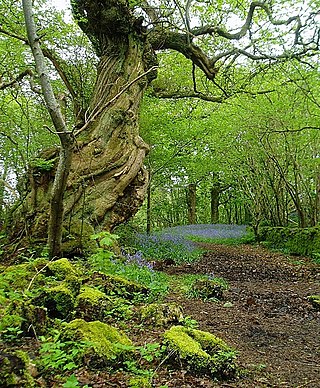
In the United Kingdom, ancient woodland is that which has existed continuously since 1600 in England, Wales and Northern Ireland. Planting of woodland was uncommon before those dates, so a wood present in 1600 is likely to have developed naturally.

<span class="mw-page-title-main">Worthing West (UK Parliament constituency)</span>

Worthing West is a constituency represented in the House of Commons of the UK Parliament since its 1997 creation by Sir Peter Bottomley, a Conservative, who is the Father of the House of Commons.

<span class="mw-page-title-main">Ferring</span> Human settlement in England

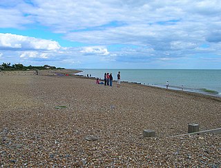
Ferring is a coastal village, civil parish and electoral ward in the Arun District of West Sussex, England. It is part of the built-up area of Worthing and is accessed along the A259 road 3 miles (4.8 km) west of the town - comprising North Down Farm and Highdown Hill to the north and the town itself to the south, with approximately equal size green buffers to the town in size, to east to Goring-by-Sea and west to East Preston.

<span class="mw-page-title-main">Castle Goring</span> Building in West Sussex, England

Castle Goring is a Grade I listed country house in Worthing, in West Sussex, England about 4.5 miles northwest of the town centre.

<span class="mw-page-title-main">Durrington, West Sussex</span> Human settlement in England

Durrington is a neighbourhood of Worthing and former civil parish, now in the borough of Worthing in West Sussex, England. Historically in Sussex, in the rape of Bramber, it is situated near the A27 road, 2.3 miles (3.7 km) northwest of the town centre. Since 1992 it has been home to the community-led Durrington Festival.

<span class="mw-page-title-main">History of Worthing</span>

Worthing is a large seaside town in Sussex, England in the United Kingdom. The history of the area begins in Prehistoric times and the present importance of the town dates from the 19th century.

<span class="mw-page-title-main">2007 Worthing Borough Council election</span>

The 2007 Worthing Borough Council election took place on 3 May 2007 to elect members of Worthing Borough Council in West Sussex, England. One third of the council was up for election and the Conservative Party stayed in overall control of the council.

<span class="mw-page-title-main">2008 Worthing Borough Council election</span>

The 2008 Worthing Borough Council election took place on 1 May 2008 to elect members of Worthing Borough Council in West Sussex, England. One third of the council was up for election and the Conservative Party stayed in overall control of the council. Overall turnout was 35%.

Worthing, a seaside town with borough status in the United Kingdom, is connected to the rest of the country by a network of major roads, a mainline railway, frequent bus and coach services and a nearby airport. Its 19th-century growth was encouraged by the development of turnpikes and stagecoach routes to London and nearby towns. By the middle of that century railway services improved journey times and conditions significantly. Suburbanisation in the 20th century was assisted by a network of bus routes.

<span class="mw-page-title-main">St Mary's Church, Goring-by-Sea</span> Church in West Sussex , United Kingdom

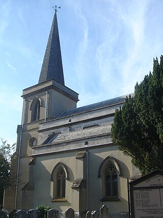
St Mary's Church is an Anglican church in the Goring-by-Sea area of the Borough of Worthing, one of seven local government districts in the English county of West Sussex. The late Norman parish church of the ancient village of Goring retains some architectural elements from that period, but Decimus Burton's comprehensive restoration of 1837 has given the church its present Gothic Revival exterior appearance. German artist Hans Feibusch, who worked extensively in the Diocese of Chichester, provided a mural in 1954: it is considered impressive, but caused controversy at the time. English Heritage has listed the church at Grade II* for its architectural and historical importance.

<span class="mw-page-title-main">St Symphorian's Church, Durrington</span> Church in West Sussex, United Kingdom

St Symphorian's Church is an Anglican church in the Durrington area of the borough of Worthing, one of seven local government districts in the English county of West Sussex. The original 13th-century chapelry declined and fell into ruins in the 17th century, partly due to damage caused by the English Civil War. Anglican worship was re-established in a tin tabernacle in 1890 as the former village grew into a suburb of Worthing, and during World War I a permanent church was built. It was extended during World War II. English Heritage has listed the building at Grade II for its architectural and historical importance.

<span class="mw-page-title-main">Speckled Wood, Hastings</span>

Speckled Wood is a 12.7-acre (5.1 ha) woodland and park in Ore Village in the Ore Valley, Hastings, East Sussex, United Kingdom. The woodland park consists of woodland trails and clearings. The woodland has steep sixty-degree sides and is a wet woodland.

<span class="mw-page-title-main">Forge Wood</span>

Forge Wood is the 14th residential neighbourhood in Crawley, a town and borough in West Sussex. The 1,900 houses and other facilities will be built on open land in the northeast of the borough, adjoining the ancient village of Tinsley Green and to the north of the Pound Hill neighbourhood.

<span class="mw-page-title-main">Ferring Rife</span> Stream in West Sussex, England

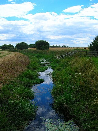
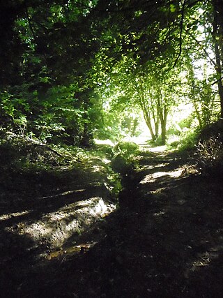
The Ferring Rife is a stream in West Sussex, England that rises in the West Durrington area of Worthing. It has multiple sources including one near Castle Goring and another in Titnore Wood. The streams converge that make up the Ferring Rife converge north of Littlehampton Road, passing through Maybridge, then west of Ferring into the sea. It flows south-west, west and then south into the English Channel, between the villages of Ferring and East Preston.

<span class="mw-page-title-main">Timeline of Worthing</span> Timeline of the history of Worthing, West Sussex, England

The following is a timeline of the history of the borough of Worthing, West Sussex, England.

References

  1. "Woodland homes plan is rejected". BBC Sussex website. BBC. 16 March 2010. Retrieved 22 March 2010.
  2. "West Durrington Design and Access Statement with Design Codes" (PDF). West Durrington Consortium. July 2008. p. 28. Retrieved 22 March 2010.
  3. 1 2 "West Durrington plans updated". Worthing Borough Council. 11 December 2009. Retrieved 22 March 2010.
  4. "Flooding: Will It Be Your Turn Next?". Protect Our Woodland. 2010. Retrieved 17 March 2010.
  5. "West Durrington Design and Access Statement with Design Codes" (PDF). West Durrington Consortium. July 2008. p. 5. Retrieved 22 March 2010.
  6. "Tree-top eco-warriors must leave". BBC News. 27 July 2006. Retrieved 19 March 2010.
  7. "West Sussex Ancient Homes Plan Rejected". The Argus newspaper. 15 March 2010. Retrieved 17 March 2010.
  8. "Plans for homes next to Worthing's Titnore Woods voted down". BBC News. 16 March 2010. Retrieved 17 March 2010.
  9. 1 2 3 4 "Appendix 3 - species list - part of the text from a study commissioned by the Worthing Society into the area that will be effected (sic) by the development". Protect Our Woodland (originally from a study commissioned by the Worthing Society). 2010. Retrieved 17 March 2010.

Commons-logo.svg Media related to Titnore Wood at Wikimedia Commons

50°50′07″N0°26′30″W / 50.8352°N 0.4417°W / 50.8352; -0.4417