The Toamasina Province is a former province of Madagascar with an area of 71,911 km². It had a population of 2,855,600 (2004). Its capital was Toamasina, the most important seaport of the country. The province was also known as Tamatave Province.

Toamasina, meaning "like salt" or "salty", unofficially and in French Tamatave, is the capital of the Atsinanana region on the east coast of Madagascar on the Indian Ocean. The city is the chief seaport of the country, situated 215 km (134 mi) northeast of its capital and biggest city Antananarivo. In 2018 Toamasina had a population of 325,857.

Dolpa District, is a district, located in Karnali Province of Nepal, It is one of the seventy-seven districts of Nepal and one of ten district of Karnali. The district, with Dunai as its district headquarters, covers an area of 7,889 km2 (3,046 sq mi) and has a population (2011) of 36,700. Dolpa is the largest district of Nepal.

Analamanga is a region in central Madagascar, containing the capital Antananarivo and its surrounding metropolitan area. The region has an area of 17,488 square kilometres, and had a population of 3,618,128 in 2018.

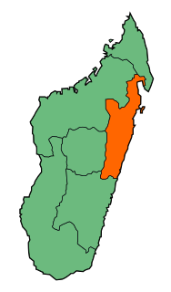
Atsinanana is a coastal region in eastern Madagascar. It borders Analanjirofo region in the north, Alaotra-Mangoro in the west, Vakinankaratra and Amoron'i Mania in the southwest, and Vatovavy and Fitovinany in south. The region contains over 285km of coastline, which includes many beaches and cultural heritage sites.
Ampasina Maningory is a rural municipality in Madagascar, located along the Maningory River, a few kilometers from the Indian Ocean. It belongs to the district of Fenerive Est, which is a part of Analanjirofo Region. The population of the commune was estimated to be approximately 36,000 in 2001 commune census.
Soanierana Ivongo is a rural municipality in Madagascar. It belongs to the district of Soanierana Ivongo, which is a part of Analanjirofo Region. The population of the commune was estimated to be approximately 26,990 in 2018.

Andasibe is a rural municipality in Madagascar. It belongs to the district of Moramanga, which is a part of Alaotra-Mangoro Region. The population of the commune was estimated to be approximately 13493 in 2006.
Sabotsy Anjiro is a rural municipality that is composed by two towns in Madagascar. It belongs to the district of Moramanga, which is a part of Alaotra-Mangoro Region. The population of the commune was estimated to be 17,418 in 2018 and lies approximately 80 km west of Antananarivo, along the National Road 2 to Toamasina.

Moramanga District is a district in the Alaotra-Mangoro region in Madagascar. Its capital is Moramanga.

'Mahanoro is a rural municipality located in the Atsinanana region of eastern Madagascar, along the coast.

Andevoranto[andevʷˈrantʷ] is a rural municipality in the Brickaville District, Atsinanana Region, Madagascar.

Brickaville District is an administrative district in Atsinanana Region, Madagascar; also known as Ampasimanolotra and Vohibinany. Brickaville is located along Route nationale 2, 105 km south of Toamasina and 220 km east of Antananarivo. It is also situated alongside the Rianila river. It is a railway station on the Antananarivo - East Coast line. Its main industries revolve around sugar.
Ampasimadinika is a rural commune in the district of Toamasina II (district), in the region of Atsinanana, on the northern part of the east coast of Madagascar. It is situated along the National road RN 2.
Antetezambaro is a rural commune in the district of Toamasina II (district), in the region of Atsinanana, on the east coast of Madagascar. It is situated along the National road RN 5, 12 km north of Toamasina.
Fanandrana is a rural commune in the district of Toamasina II (district), in the region of Atsinanana, on the east coast of Madagascar. It is situated at the National road RN 2 at 26 km from Toamasina. The Ivondro River flows through the center of Fanandrana, and the Fanandrana river in its south.
Amboditandroho is a rural commune in the district of Toamasina II (district), in the region of Atsinanana, on the east coast of Madagascar. It is situated at the National road RN 2 at 15 km from Toamasina.
Antenina is a rural municipality in the district of Toamasina II (district), in the region of Atsinanana, on east coast of Madagascar.
Ifito is a rural municipality in the district of Toamasina II (district), in the region of Atsinanana, on east coast of Madagascar.

