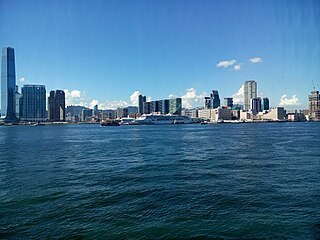
Hong Kong Island is an island in the southern part of Hong Kong. Known colloquially and on road signs simply as Hong Kong, the island had a population of 1,289,500 and a population density of 16,390 per square kilometre (42,400/sq mi), as of 2008. The island had a population of about 3,000 inhabitants scattered in a dozen fishing villages when it was occupied by the United Kingdom in the First Opium War (1839–1842). In 1842, the island was formally ceded in perpetuity to the UK under the Treaty of Nanking and the City of Victoria was then established on the island by the British Force in honour of Queen Victoria. The Central area on the island is the historical, political and economic centre of Hong Kong. The northern coast of the island forms the southern shore of the Victoria Harbour, which is largely responsible for the development of Hong Kong due to its deep waters favoured by large trade ships.

Kowloon is an urban area in Hong Kong comprising the Kowloon Peninsula and New Kowloon. With a population of 2,019,533 and a population density of 43,033/km2 (111,450/sq mi) in 2006, it is the most populous area in Hong Kong, compared with Hong Kong Island and the rest of the New Territories. The peninsula's area is about 47 km2 (18 sq mi).

Sha Tin District is one of the 18 districts of Hong Kong. As one of the 9 districts located in the New Territories, it covers the areas of Sha Tin, Tai Wai, Ma On Shan, Fo Tan, Siu Lek Yuen, Kwun Yam Shan and Ma Liu Shui. The district is the most populous district in Hong Kong, with a population of 659,794 as per 2016 by-census, having a larger population than many states or dependencies including Iceland, Malta, Montenegro and Brunei.

Sai Kung District is one of the 18 districts of Hong Kong. The district comprises the southern half of the Sai Kung Peninsula, the Clear Water Bay Peninsula in the New Territories and a strip of land to the east of Kowloon. Areas in the district include Sai Kung Town, Hong Kong UNESCO Global Geopark, Tseung Kwan O and over 70 islands of different sizes. The administrative centre had been located in Sai Kung Town until the Sai Kung District Office was relocated to Tseung Kwan O recently. The district's population is concentrated in Tseung Kwan O, as of 2011. In 2011, the district was the third youngest district, with a median age of 39.3. Known as the "back garden of Hong Kong", Sai Kung has been able to retain its natural scenery. Many traditional customs and cultures are still retained in the rural villages.

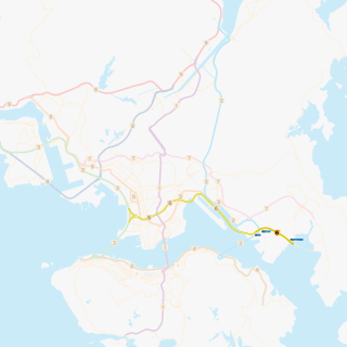
The Kwun Tong line is a rapid transit line of the MTR network in Hong Kong, coloured green on the MTR map. Starting at Whampoa in Hung Hom and ending at Tiu Keng Leng in Tseung Kwan O, Sai Kung, the route has 17 stations and takes 35 minutes to complete. The Kwun Tong line is one of the busiest railway lines on the network connecting the central and the eastern portions of Kowloon via Wong Tai Sin. The line is mostly underground, but includes a lengthy elevated section, and runs generally in an east-west direction. During the morning rush hour, the Kwun Tong line utilises 33 trains running at 29tph to achieve a route capacity of 85,000 pphpd.

Tseung Kwan O New Town is one of the nine new towns in Hong Kong, built mainly on reclaimed land in the northern half of Junk Bay in southeastern New Territories, after which it is named. The town/land area is usually known simply as Tseung Kwan O.

Tseung Kwan O Tunnel is a 900-metre tunnel beneath Ma Yau Tong in Hong Kong. The tunnel was opened on 9 November 1990. Part of Route 7, it links Sau Mau Ping, Kwun Tong, Kowloon and the Tseung Kwan O New Town, Sai Kung District, the New Territories. It was used by 80,385 vehicles daily in 2011.

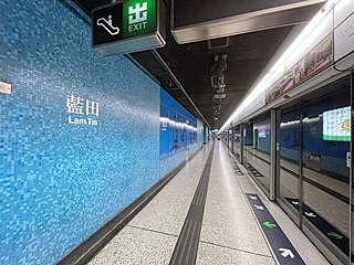
Lam Tin is a station on the Hong Kong MTR Kwun Tong line built as a part of the extension to Quarry Bay. The station is linked to the nearby hillside community of Lam Tin by a series of escalators.

The Eastern Harbour Crossing, abbreviated as "EHC", is a combined road-rail tunnel that crosses beneath Victoria Harbour in Hong Kong. Opened on 21 September 1989, it connects Quarry Bay, Hong Kong Island and Cha Kwo Ling, Kowloon East.
This article is a list of transport means that cross Victoria Harbour in Hong Kong.

Kwun Tong is one of the 18 districts of Hong Kong. It is located in Kowloon, and is the easternmost and southernmost district in Kowloon. It had a population of 648,541 in 2016. The district has the second highest population in Hong Kong, after Sha Tin District, while the income is below average. Kwun Tong District borders Sai Kung District to the east, Wong Tai Sin District to the north, and Kowloon City District to the west. To the south is Victoria Harbour, and the Eastern District directly across on Hong Kong Island.

Lam Tin is an area in the Kwun Tong District in southeastern New Kowloon, Hong Kong. Lam Tin is primarily a residential area but also hosts a major transport interchange and several shopping attractions. Lam Tin was once a large field in the vicinity of Kowloon Bay. During the Song dynasty, it was a site of salt production. Since the 1980s, a number of housing estates were constructed in Lam Tin.

Route 6 is a partially open trunk route in Hong Kong, planned to be completed in its entirety in 2026. It is the newest trunk route to be numbered under the Strategic Route Number System. The section between Tseung Kwan O and Lam Tin consisting of the new Cross Bay Link and Tseung Kwan O–Lam Tin Tunnel opened to traffic on the 11th of December, 2022. This is the first and so far the only portion of Route 6 which is open. Its eastern terminus is at the Tseung Kwan O Interchange of the Cross Bay Link. Although not officially part of Route 6, the Cross Bay Link carries traffic further to its two eastern termini, one at Po Shun Road in Tseung Kwan O and the other at Wan O Road in LOHAS Park. The western terminus is the unfinished Lam Tin Interchange with the Eastern Harbour Crossing of Route 2 at Lam Tin.

The Hong Kong Strategic Route and Exit Number System is a system adopted by the Transport Department of the Hong Kong Government to organise the major roads in the territory into routes 1 to 10 for the convenience of drivers. When the system was implemented in 2004, the government promoted it with a major public campaign, including the slogan "Remember the Numbers; Make Driving Easier".

The Hong Kong government started developing new towns in the 1950s to accommodate Hong Kong's booming population. During the first phase of development, the newly developed towns were called "satellite towns", a concept borrowed from the United Kingdom, of which Hong Kong was a colony. Kwun Tong, located in eastern Kowloon, and Tsuen Wan, located in the south-west of the New Territories, were designated as the first satellite towns, when the urban area in Hong Kong was still relatively small, restricted to the central and western parts of Kowloon Peninsula and the northern side of Hong Kong Island. Wah Fu Estate was also built in a remote corner on the southern side of Hong Kong Island, with similar concepts but at a smaller scale.

Black Hill is a hill in Hong Kong with a height of 304 metres. It is located between the communities of Lam Tin, Kowloon and Tiu Keng Leng, Sai Kung.


