Transport in Saint Kitts and Nevis

Last updated

Transport in Saint Christopher and Nevis (a two-island federation) includes normal road traffic, public buses, taxis, ferries, airports, and one railway.

Contents

Basseterre is the hub for all major roads in Saint Christopher. Charlestown, Nevis is the equivalent hub in Nevis. Driving is on the left.

The speed limit in settled areas is 40 km/h, with special caution to be taken around school zones. In rural areas the speed limit is 60 km/h.

The total length of roads in Saint Christopher and Nevis is 320 km. In 1999 it was estimated that 136 km were paved, and 184 km were unpaved. [1]

Public buses

The public buses are privately owned, but government-licensed, vans. They sometimes have a decorative name on the front, and they all have a green licence plate where the number starts with the letter "H" or "HA".

A bus may be flagged down anywhere along its route (not just at bus stop shelters), and the bus will also stop anywhere along its route (on request) to let off a passenger.

All bus fees (in Eastern Caribbean or EC dollars) are $2.50 for a trip of 5 miles or under, $3.00 for a trip of 5 to 10 miles, and $3.75 for a trip over 10 miles. ($1 US = $2.7 EC)

Destinations off of the main route are often possible on request, at the discretion of the driver, on payment of a small extra charge.

St. Kitts

There are 5 main bus routes on St. Kitts:

(No public buses travel southwards to the main resort areas in Frigate Bay and the Southeast Peninsula of St. Kitts.)

Nevis

On Nevis, buses run both ways along the main ring-road around the island. All buses start off, and eventually finish up, in the capital of Nevis, Charlestown. Buses that will be travelling north out of Charlestown wait to leave from the southwest end of D. R. Walwyn Plaza. Buses travelling south from Charlestown wait to leave from the northern end of Memorial Square. At the termination points you can board a bus and wait for it to fill up before it leaves. If you are not sure you are climbing into the right bus, ask the driver if he goes to your destination.

Taxis

Taxis are privately owned, but government licensed, vans. These vans usually have a name, and they all have yellow license plates where the number starts with the letter "T" or "TA".

The main taxi stand on St. Kitts is in Basseterre, on The Circus, phone number 466 6999, and there is a taxi stand at the airport too.

The main taxi stand on Nevis is in Charlestown, on the west side of D.R. Walwyn Plaza, and there is also a taxi stand at the airport.

A taxi can traverse any accessible area on the islands, including even dirt roads and trails, if the driver agrees.

Harbours and ferries

Saint Kitts and Nevis ferry terminal Basseterre ferry terminal.JPG
Saint Kitts and Nevis ferry terminal

St. Kitts

Basseterre is the location of all official harbouring services on Saint Kitts, though Coast Guard stations exist at Sandy Point Town and Dieppe Bay Town. The Deep Water Harbour at Basseterre is capable of both hosting and berthing of cruise ships or the handling of cargos. It is located to the extreme East of Basseterre Bay.

Port Zante, in the centre of Basseterre Bay, is for use of docking cruise ships only. The Port can accommodate the largest cruise ships in the world. It also has a marina facility.

The bay is also home to the popular ferry connection between Basseterre, St. Kitts and Charlestown, Nevis. There are several trips daily. On rare occasions there is a special ferry day trip from Basseterre to Oranjestad, St Eustatius and back again.

A relatively new (started in 2007) car ferry, which can take up to 35 cars and also takes pedestrian passengers, is called the "Sea Bridge" ferry, and is in operation between the two islands. This ferry traverses the narrow, 2-mile wide straight named 'The Narrows' between the two islands in 25 minutes, from Major's Bay in St. Kitts (at the tip of the southeastern peninsula), to Cades Bay in Nevis. Cars can also be carried by the "Sea Hustler" ferry, which operates out of Basseterre.

Nevis

Charlestown is the harbour for the government ferries which run between Charlestown and Basseterre on St. Kitts Archived 2007-05-29 at the Wayback Machine . There is a deep water port on the southern coast of Nevis for cargo ships.

The "Sea Bridge" ferry, which takes cars (and also pedestrians), docks in the northwest part of Nevis at Cades Bay, and runs between there and Majors Bay on St. Kitts. The Sea Bridge ferry runs six times a day in each direction Archived 2008-06-23 at the Wayback Machine . For pedestrians it is worth noting that there are no facilities of any kind at Majors Bay (no houses, no businesses, etc.), only a small wooden gazebo as shelter from sun or rain, and so, if you have not already arranged to be met at Majors Bay by car or taxi, you will have to enjoy Majors Bay for a couple of hours in its more or less wild state before taking the ferry back to Nevis.

Airports

Robert L. Bradshaw International Airport St. Kitts Airport Terminal from side.jpg
Robert L. Bradshaw International Airport

St. Kitts

The Robert L. Bradshaw International Airport (IATA airport code SKB/TKPK) serves the city of Basseterre, and by extension the island of Saint Kitts. The airport is located in the south of the parish of Saint Peter Basseterre on the north-eastern periphery of the city of Basseterre. The 8001-foot runway airport has direct flights to London, New York and Miami, and seasonal flights to Charlotte, NC, and Philadelphia, PA, in addition to other major cities in the US and Canada during the tourist season.

Nevis

The Vance W. Amory International Airport (IATA airport code NEV/TKPN) serves the island of Nevis. The airport runway is 4002 feet in length. Many flights connect from here to other Caribbean islands, including Puerto Rico.

Railway

St. Kitts Scenic Railway St. Kitts Scenic Railway (3357634274).jpg
St. Kitts Scenic Railway

St. Kitts has a 29 km (18 mi) 2 ft 6 in (762 mm) narrow-gauge railway, which centres in the capital, Basseterre, and circles the island. The railway line was originally built between 1912 and 1926 to transport sugar cane to the central sugar factory in Basseterre. The last sugar cane load was delivered to the now-defunct factory in 2005. Since 2003 the railway has offered a circle tour of the island aboard specially designed open-air, double-decker coaches primarily for tourists. [2] The St. Kitts Scenic Railway train currently runs from Sandy Point to Basseterre, travelling east.

See also

Related Research Articles

<span class="mw-page-title-main">Transport in Hong Kong</span> Overview of the transport in Hong Kong

Hong Kong has a highly developed transport network, encompassing both public and private transport. Based on Hong Kong Government's Travel Characteristics Survey, over 90% of daily journeys are on public transport, the highest rate in the world. However, in 2014 the Transport Advisory Committee, which advises the Government on transportation issues, issued a report on the much-worsened congestion problem in Hong Kong and pointed at the excessive growth of private cars during the past 10–15 years.

<span class="mw-page-title-main">Nevis</span> Island in the Caribbean Sea

Nevis is a small island in the Caribbean Sea that forms part of the inner arc of the Leeward Islands chain of the West Indies. Nevis and the neighbouring island of Saint Kitts constitute the Federation of Saint Kitts and Nevis, a singular nation state. Nevis is located near the northern end of the Lesser Antilles archipelago about 350 kilometres (220 mi) east-southeast of Puerto Rico and 80 kilometres (50 mi) west of Antigua. Its area is 93 square kilometres (36 sq mi) and the capital is Charlestown.

<span class="mw-page-title-main">Saint Kitts and Nevis</span> Country in the West Indies

Saint Kitts and Nevis, officially the Federation of Saint Christopher and Nevis, is an island country consisting of the two islands of Saint Kitts and Nevis, both located in the West Indies, in the Leeward Islands chain of the Lesser Antilles. With 261 square kilometres (101 sq mi) of territory, and roughly 50,000 inhabitants, it is the smallest sovereign state in the Western Hemisphere, in both area and population, as well as the world's smallest sovereign federation. The country is a Commonwealth realm, with Charles III as King and head of state.

<span class="mw-page-title-main">History of Saint Kitts and Nevis</span>

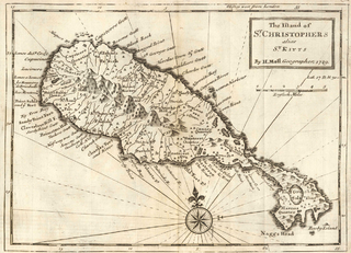
Saint Kitts and Nevis have one of the longest written histories in the Caribbean, both islands being among Spain's and England's first colonies in the archipelago. Despite being only two miles apart and quite diminutive in size, Saint Kitts and Nevis were widely recognized as being separate entities with distinct identities until they were forcibly united in the late 19th century.

<span class="mw-page-title-main">Geography of Saint Kitts and Nevis</span> Regions of St.Kitts And Nevis

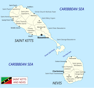
Saint Kitts and Nevis is a twin island country with a total landmass of just 270 square kilometres (104 sq mi). The island of St. Kitts, the larger of the two, is 180 square kilometres (68 sq mi) in size and is located at latitude 17.30 N, and longitude 62.80 W. Nevis is 93 square kilometres (36 sq mi) and located at latitude 17.10 N, longitude 62.35 W, approximately 3 km south-east of St. Kitts. The islands are about one-third of the way from Puerto Rico to Trinidad and Tobago. The islands are volcanic and mountainous.

<span class="mw-page-title-main">Saint Kitts</span> Island in the West Indies; part of the Federation of St. Kitts and Nevis

Saint Kitts, officially Saint Christopher, is an island in the West Indies. The west side of the island borders the Caribbean Sea, and the eastern coast faces the Atlantic Ocean. Saint Kitts and the neighbouring island of Nevis constitute one country: the Federation of Saint Kitts and Nevis. Saint Kitts and Nevis are separated by a shallow 3-kilometre (2 mi) channel known as "The Narrows".

<span class="mw-page-title-main">Transportation in the United States Virgin Islands</span>

The United States Virgin Islands (USVI) is the only place under United States jurisdiction where the rule of the road is to drive on the left. However, virtually all passenger vehicles are left hand drive due to imports of U.S. vehicles.

<span class="mw-page-title-main">Basseterre</span> Capital of Saint Kitts and Nevis

Basseterre is the capital and largest city of Saint Kitts and Nevis with an estimated population of 14,000 in 2018. Geographically, the Basseterre port is located at 17°18′N62°44′W, on the south western coast of Saint Kitts Island, and it is one of the chief commercial depots of the Leeward Islands. The city lies within Saint George Basseterre Parish.

<span class="mw-page-title-main">Economy of Saint Kitts and Nevis</span>

The economy of Saint Kitts and Nevis has traditionally depended on the growing and processing of sugar cane; decreasing world prices have hurt the industry in recent years. Tourism, export-oriented manufacturing, and offshore banking activity have assumed larger roles in Saint Kitts and Nevis. Most food is imported. The government has undertaken a program designed to revitalize the faltering sugar sector. It is also working to improve revenue collection in order to better fund social programs. In 1997, some leaders in Nevis were urging separation from Saint Kitts on the basis that Nevis was paying far more in taxes than it was receiving in government services, but the vote on cessation failed in August 1998. In late September 1998, Hurricane Georges caused approximately $445 million in damages and limited GDP growth for the year.

<span class="mw-page-title-main">Charlestown, Nevis</span> Place in Nevis, Saint Kitts and Nevis

Charlestown is the capital of the island of Nevis in the Federation of Saint Kitts and Nevis in the Leeward Islands of the West Indies. Charlestown is situated on the leeward side of the island of Nevis near the southern end of Pinney's Beach.

Carib Aviation was an airline based in Antigua and Barbuda.

<span class="mw-page-title-main">Robert L. Bradshaw International Airport</span> Airport in Basseterre

Robert L. Bradshaw Airport, formerly known as Golden Rock Airport, is an international airport located just northeast of Basseterre, on the island of Saint Kitts, serving the nation of Saint Kitts and Nevis. It was named after the first Premier of St. Kitts-Nevis-Anguilla, Robert Llewellyn Bradshaw. In 2008, the airport handled 399,706 passengers.

<span class="mw-page-title-main">Saint George Basseterre Parish</span> Parish in Saint Kitts and Nevis

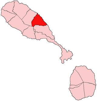
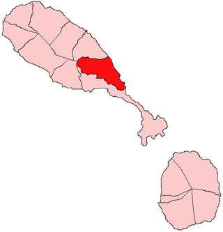
Saint George Basseterre is one of 14 administrative parishes that make up Saint Kitts and Nevis. It is the largest parish on Saint Kitts and the second largest parish in Saint Kitts and Nevis. It is by far the most populous parish in the federation, holding nearly a third of the country's population. It is home to the city of Basseterre, capital of Saint Kitts and Nevis, and also has a longer coastline than any other parish in Saint Kitts and Nevis.

<span class="mw-page-title-main">Saint John Capisterre Parish</span> Parish in Saint Kitts and Nevis

Saint John Capisterre is one of 14 administrative parishes that make up Saint Kitts and Nevis. It is the second largest parish on Saint Kitts, and the third largest parish in the federation. The capital of the parish is Dieppe Bay Town.

<span class="mw-page-title-main">Saint Mary Cayon Parish</span> Parish in Saint Kitts and Nevis

Saint Mary Cayon is one of 14 administrative parishes that make up Saint Kitts and Nevis. It is located on the main island of Saint Kitts and the parish capital is Cayon.

<span class="mw-page-title-main">Saint Peter Basseterre Parish</span> Parish in Saint Kitts and Nevis

Saint Peter Basseterre is one of 14 administrative parishes that make up Saint Kitts and Nevis. It is located on the main island of Saint Kitts and the parish capital is Monkey Hill.

<span class="mw-page-title-main">Saint Paul Charlestown Parish</span> Parish in Saint Kitts and Nevis

Saint Paul Charlestown is one of 14 administrative parishes that make up Saint Kitts and Nevis. It is located on the island of Nevis, and the parish capital is Charlestown, which is also capital of the entire island.

Most narrow-gauge railways in North America were constructed with 3 ft track gauge.

<span class="mw-page-title-main">St. Kitts Scenic Railway</span>

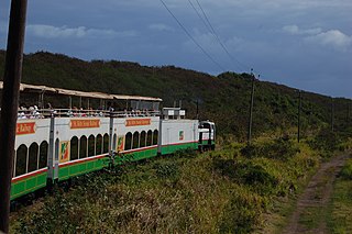
St. Kitts Scenic Railway is a 29 kilometres (18 mi) long narrow-gauge railway line along the coastline of the island of St. Kitts in the eastern Caribbean, with a track gauge of 762 mm.

The St. Theresa Church and alternatively St. Theresa Parish, is a religious building of the Catholic church that is located in Main Road in the town of Charlestown, capital of Nevis Island and Saint Paul Charlestown Parish one of the 14 in the Caribbean and island federation of St. Kitts and Nevis in the Lesser Antilles.

References

Notes

  1. CIA.gov [ dead link ]
  2. St. Kitts Scenic Railway, official site, accessed 15 December 2012.

Further reading

  • Horsford, Jim (2004). The St Kitts Railway: From Sugar Cane to Scenic Train. St. Teath, Cornwall: Paul Catchpole. ISBN   9781900340182.