Transportation in Greater St. Louis, Missouri includes road, rail, ship, and air transportation modes connecting the bi-state St. Louis metropolitan area with surrounding communities throughout the Midwest, national transportation networks, and international locations. The Greater St. Louis region also supports a multi-modal transportation network that includes bus, paratransit, and light rail service in addition to shared-use paths, bike lanes and greenways.
Olive Street in downtown St. LouisForest Park Parkway in downtown Clayton
The city of St. Louis has several major arterial roadways and boulevards. Important north-south routes include Broadway, Tucker Boulevard (which turns into Gravois Avenue and runs southwest to the city limits), Jefferson Avenue, Grand Boulevard, Vandeventer Avenue, Kingshighway Boulevard, and finally Skinker Boulevard. The latter two run on the east and west edges of Forest Park, respectively. Several of the city's primary arterials also continue into the St. Louis County suburbs. Some of those routes include West Florissant Avenue, Natural Bridge Avenue, and Dr. Martin Luther King Drive (which turns into St. Charles Rock Road), all of which carry traffic from downtown to the North County suburbs. Others are Clayton Road, Manchester Avenue, Chippewa Street (which turns into Watson Road), and South Broadway (eventually turning into Telegraph Road), all of which carry traffic from the city to the West and South County suburbs.
Other major corridors between the city and county include Market Street-Forest Park and Olive Boulevard. Market Street begins at the Arch Grounds and continues west, eventually turning into Forest Park Avenue in Midtown. After crossing Kingshighway in the Central West End, the name changes to Forest Park Parkway and the road takes on characteristics more similar to a divided highway until it reaches its terminus at Interstate 170 near downtown Clayton. Olive Boulevard, which is unrelated to downtown's Olive Street, begins at Skinker Boulevard on the city-county line and runs due west through the suburbs of University City, Olivette, Creve Coeur, and Chesterfield where it turns south and changes to Clarkson Road at Interstate 64. From here it continues through Clarkson Valley before ending at Manchester Road in Ellisville, Missouri.
Other county arterials include major north-south routes like Big Bend Boulevard, Hanley Road, Laclede Station Road, Lindbergh Boulevard, and Ballas Road.
The "beltway" serving Greater St. Louis is the combination of Interstate 270 and Interstate 255, the former a mostly western bypass of St. Louis City. I-270 crosses into Illinois at the northern edge of the city on the New Chain of Rocks Bridge and continues through Madison County, Illinois, until ending at the I-55 and I-70 interchange near Troy. In southern St. Louis County, I-270 ends at the I-55 interchange near Mehlville, Missouri, where the roadway becomes I-255 and continues east across the Mississippi River on the Jefferson Barracks Bridge into Monroe County, Illinois. Here it turns north, traveling through St. Clair County until ending at I-270 in Madison County. Known locally as the "Inner Belt Expressway," Interstate 170 runs entirely within St. Louis County, traveling southerly from I-270 in Hazelwood to I-64 in Richmond Heights.
Other secondary highways in the area include Highway 141 (originally designed as a western "outer belt" to I-270) and highways 364 and 370 which serve suburban St. Charles County.
U.S. Route 50 enters Greater St. Louis near Gerald, eastward through Franklin County; at Union, it meets I-44, both continuing to Sunset Hills in St. Louis County. US 50, eastward, merges with US 61 and U.S. Route 67 (Lindbergh Boulevard). The US 50/US 61/US 67 concurrency continues to the I-55/I-255/I-270 interchange, where they follow I-255 across the Mississippi River. US 50 continues east through Monroe County into St. Clair County, traveling concurrently with I-64 into O'Fallon, where US 50 splits, continuing through Clinton County.
US 61 enters the region from the south, paralleling I-55 in Jefferson County, continuing to Festus where it travels concurrently with US 67. US 61/US 67 continues into St. Louis County until reaching the I-55/I-255/I-270 interchange, where US 61/US 67 follows Lindbergh Boulevard. US 61 continues north into Frontenac, where it joins westbound I-64. US 61 continues west through St. Louis County and into St. Charles County, then leaves I-64 in Wentzville and continues north into Lincoln County and beyond.
US 67 enters the region northbound in Farmington, Missouri, where it continues into Festus, traveling concurrently with US 61 and paralleling I-55. US 67 splits from US 61 in Frontenac with US 67 continuing north on Lindbergh Boulevard. At Missouri Route 367, US 67 turns north, crosses the Missouri River on the Clark Bridge into Illinois and passes through Madison and Jersey counties before leaving the region.
The Greater St. Louis region is also served by several state highways that are listed in the table below.
Interstates and State Highways serving Greater St. Louis
The Stan Musial Veterans Memorial Bridge at St. LouisThe Clark Bridge carries U.S. Highway 67 across the Mississippi River
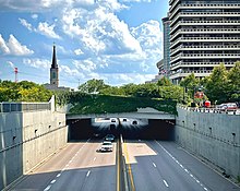
The Greater St. Louis region is surrounded by rivers, creeks, and other tributaries requiring multiple bridges and viaducts to travel across the bi-state area. The largest of these bridges carry interstates across rivers while the smaller viaducts carry major local routes over creeks, railroads, and other obstructions. Missouri's only traffic tunnel carries Lindbergh Boulevard under Runway 11/29 at St. Louis-Lambert International Airport.
Major Bridges, Viaducts, and Tunnels in Greater St. Louis
Local bus service in the greater St. Louis region is provided by MetroBus and Madison County Transit. MetroBus has 46 routes connecting destinations in the city of St. Louis and St. Louis County in addition to 13 routes connecting destinations in St. Clair County, Illinois.[1] Madison County Transit has 26 routes connecting destinations across Madison County, Illinois. In addition, Madison County Transit runs express buses to the Civic Center and Emerson Park transit centers where passengers can connect with MetroLink trains.
Fixed rail public transportation in the St. Louis region consists of two light rail lines serving the same stations in the central city and then branching to different destinations outside the city. Both lines enter the city on its western edge north of Forest Park or on the Eads Bridge in downtown St. Louis from Illinois. The whole system operates in an independent right of way, with at-grade, elevated, and subway track in the region. All stations are independent entry and all platforms feature level boarding with trains. Rail service is provided by Metro Transit, an enterprise of the Bi-State Development Agency, and is funded by sales taxes levied in the city and St. Louis and St. Clair counties.[2]
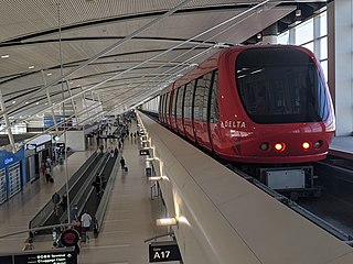
A 5.2-mile (8.4km) extension of the Red Line from Shiloh-Scott to MidAmerica St. Louis Airport in Mascoutah broke ground in 2023 and is expected to be operational by 2026.[3][4][5] In Missouri, Metro and local leaders are planning a line that would run between North and South St. Louis with a potential extension into North St. Louis County.[6][7]
The Loop Trolley near Limit Avenue in University City
The Loop Trolley is a 2.2-mile (3.5km), 10-station heritage streetcar line that runs from City Hall in University City to the Missouri History Museum in St. Louis' Forest Park. The line travels along Delmar Bouleverd through the popular Delmar Loop district and DeBaliviere Avenue between Delmar and Forest Park. The trolley has stops at both the Forest Park-DeBaliviere and Delmar Loop MetroLink stations. On February 18, 2022, Metro Transit's board voted to take over operation of the Loop Trolley after several financial setbacks and closures.[8] Metro reopened the Loop Trolley for operation on August 4, 2022.[9] On August 21, 2022, the East-West Gateway Council of Governments voted to award Metro a $1.26 million grant to continue to operate the trolley on a seasonal schedule for the next several years.[10]
Taxicab service in the region is provided by private companies regulated by the Metropolitan Taxicab Commission. Rates vary by vehicle type, size, passengers and distance, and by regulation all taxicab fares must be calculated using a taximeter and be payable in cash or credit card.[11] Solicitation by a driver is prohibited, although a taxicab may be hailed on the street or at a stand. The St. Louis region is also served by rideshare companies like Lyft, Uber, Lime, and Bird.
Ferries
The St. Louis metropolitan area is home to several ferry services that carry passengers across rivers between Missouri and Illinois.[12] The seasonal Grafton Ferry travels across the Mississippi River between St. Charles, Missouri, and Grafton, Illinois, cutting travel times between the two communities by roughly 30 minutes.[13] The Calhoun Ferry Company operates two ferry services on the Mississippi River. One is a year round service between St. Charles and Calhoun County called the Golden Eagle Ferry. The other operates between Winfield, Missouri, and Batchtown, Illinois, when demand is high enough to require it.[14] The Illinois Department of Transportation also operates two free, year round ferries in the St. Louis area. The first is the Brussels Ferry that crosses the Illinois River just west of its confluence with the Mississippi near Grafton, while the second one crosses the Illinois River near Kampsville.[15] Several local roads used to lead to now closed ferries and are still named as such: Dougherty Ferry Road, Lemay Ferry Road and Tesson Ferry Road.[12]
Bicycle and pedestrian
The St. Louis area is served by several systems of off-street shared-use paths, on-street bicycle lanes, and greenways providing residents alternative modes of transportation.
Bike St. Louis
Bike St. Louis is a plan sponsored by the city of St. Louis to make local neighborhoods more friendly for those who bicycle for transportation, fitness, or fun. Since its launch in 2000, more than 135 miles of cycling routes have been added to city streets.[16]
The Great Rivers Greenway District was established in November 2000 by the passage of Proposition C – The Clean Water, Safe Parks and Community Trails Initiative – in the city of St. Louis, St. Louis County and St. Charles County, Missouri.[17] Proposition C created a one tenth of one cent sales tax devoted to the creation of an interconnected system of greenways, parks and trails. In its first 20 years the agency has built more than 128 miles of greenways connecting parks, rivers, schools, neighborhoods, business districts and transit.[18]
Major greenways include:
Brickline Greenway - The plan for the Brickline Greenway, formerly known as the Chouteau Greenway,[19] calls for 20 miles of trails and green space connecting 17 neighborhoods across the City of St. Louis. It will connect Fairground Park in the north to Tower Grove Park in the south and Forest Park in the west to Gateway Arch National Park in the east.[20] The project planners aim to knit together diverse communities through the greenway to overcome barriers that have fragmented the city over time. The plan incorporates input from citizens on strategies to promote economic growth and equitable outcomes.[21]
Centennial Greenway - The Centennial Greenway will extend from Forest Park in the City of St. Louis to St. Charles County. Three sections have been completed. From Forest Park the trail runs through the Washington University campus to Delmar Boulevard and Vernon Avenue in University City. Another section extends from Shaw Park in Clayton north to Olive Boulevard. A third section goes from the Katy Trail to the St. Charles Heritage Museum and connects east across the Missouri River to Creve Coeur Lake Memorial Park via the Creve Coeur Connector Trail.[22]
Gravois Greenway: Grants Trail - Grant's Trail on the Gravois Greenway runs along Gravois Creek on the rail corridor of the former Kirkwood-Carondelet branch of the Missouri Pacific Railroad. Trailnet, a St. Louis-based organization that advocates for active communities and safe spaces for walking and bicycling, purchased the corridor in 1991 and built the first six miles of Grant's Trail which opened in 1994.[23] Since 2006, Great Rivers Greenway has extended the trail to reach 10 miles from Kirkwood to the River des Peres Greenway near Interstate 55 and added two miles of trail in Officer Blake C. Snyder Memorial Park, adjacent to Grant’s Trail. Points of interest on the greenway include the Ulysses S. Grant National Historic Site, Grant's Farm and the Thomas Sappington House Museum.[24]
Mississippi Greenway - The Mississippi Greenway, formerly known as the Confluence Greenway, is planned as a 32 mile corridor that will connect with the Missouri, Maline, River des Peres and Meramec Greenways. Three sections have been built. The Riverfront Trail runs from the downtown Mississippi riverfront north to the old Chain of Rocks Bridge.[25] At 5,353 feet long, the old Chain of Rocks Bridge was part of Route 66 in 1936[26] and is one of the world’s longest bicycle and pedestrian bridges.[27] Another segment connects Jefferson Barracks County Park with River City Casino near the River des Peres Greenway. A third section runs through Cliff Cave County Park overlooking the Mississippi River.
Katy Trail
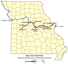
The Katy Trail (red) and the Missouri River (blue) on a map of Missouri
It enters the St. Louis region near Washington, primarily running along the Missouri River passing through historic downtown St. Charles before terminating at Machens Road, 3-miles (4.8km) from Portage Des Sioux. The Katy Trail connects to the local Great Rivers Greenway network at many points, including major bridges (Daniel Boone, Discovery, and Veterans Memorial) which provide access into St. Louis County.
The Minoru Yamasaki designed Terminal 1 at St. Louis-Lambert International AirportTerminal 1 ticketing level at St. Louis-Lambert International Airport
Greater St. Louis is severed by over a dozen airports, although the vast majority of its air traffic is generated at St. Louis Lambert International Airport.
St. Louis Lambert International Airport, owned and operated by the city of St. Louis, is 14 miles (23km) northwest of downtown along I-70 between I-170 and I-270 in St. Louis County. It is the largest and busiest airport in the state. In 2023, it served nearly 15 million passengers with more than 270 daily departures to 80 nonstop domestic and international locations.[31] Named for Albert Bond Lambert, an Olympic medalist and prominent St. Louis aviator, the airport rose to international prominence in the 20th century thanks to its association with Charles Lindbergh, its groundbreaking air traffic control (ATC), its status as the primary hub of Trans World Airlines (TWA), and its iconic terminal.[32] The airport's largest airline is Southwest Airlines with nearly 63% of the market share followed by American Airlines with 11%.[33]
MidAmerica St. Louis Airport is a public use airport next to Scott Air Force Base. It is 16 miles (26km) east of the central business district of Belleville and 21 miles (33km) east of downtown St. Louis in St. Clair County, Illinois. The airport is the secondary domestic passenger airport for the metropolitan area and has operated as a joint use airport since beginning operations in November 1997. MidAmerica is currently served by Allegiant Air and offers general aviation and cargo facilities and in 2022 saw 163,210 passengers.[34] In 2021, construction began on a 41,000 square foot expansion of the terminal building that added two additional gates. It celebrated its grand opening in June 2023.[35]
A 5.2-mile (8.4km) extension of the MetroLink Red Line from Shiloh-Scott to MidAmerica is expected to open in 2026.[36][37]
General Aviation
Other airports serving the St. Louis metropolitan area include:
Italics indicate infrastructure currently in use by MetroLink
(I) indicates intermodal yard
Port of Metropolitan St. Louis
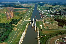
Barges pass beneath the Eads and Martin Luther King bridges at St. LouisLock 27 at the Chain of Rocks Canal
The Port of Metropolitan St. Louis offers a 15-mile stretch of the Mississippi River that is home to 16 barge-transfer facilities that, at total capacity, can handle 150 barges a day – the highest level of capacity anywhere along the Mississippi River.[41]
The St. Louis region’s port system is the second-largest inland port system in the United States, and was ranked the most efficient port system by the U.S. Army Corps of Engineers. The St. Louis regional port system is responsible for 8% of the 855 miles of the Mississippi River, but carries one-third of the river’s total freight.[42]
Other features of the Port of Metropolitan St. Louis include:
Northernmost ice-free and lock-free port on the Mississippi River
Served by six Class I railroads, seven interstates, and two international airports
Other port facilities in metropolitan St. Louis include America's Central Port in Granite City, Illinois, Kaskaskia Port in Randolph County, and the Municipal River Terminal in the city of St. Louis. In Jefferson County, Missouri, Hawtex Development Group hopes to develop a container-on-vessel port at Herculaneum's Riverview Commerce Park. The proposed port would cover approximately 300 acres and open in late 2024.[43]
The Chain of Rocks Canal and Locks No. 27 allow river traffic to bypass a portion of the Mississippi River that is unnavigable in low water due to an anticlinal exposure of bedrock in the river—a "chain of rocks". The 8.4-mile (13.5km) canal, 1,200-foot (370 m) main lock, and 600-foot (180 m) auxiliary lock opened in the early 1950s to allow a bypass of the Chain of Rocks lying in the main channel of the Mississippi River. Locks No. 27 are the only locks south of the confluence of the Mississippi River and Missouri River. As such, the locks move more cargo than any other navigation structure on the river.
St. Louis Regional Freightway
An enterprise of the Bi-State Development Agency, the Regional Freightway was founded in 2014 to enhance the St. Louis region’s standing as an international freight hub. The Freightway works to optimize the region’s freight network and strengthen modal flexibility, support workforce development initiatives that build our talent supply chain, and raise awareness about the global connectivity the St. Louis region offers.[44]
Current and future projects
Bridges and highways
Chain of Rocks Bridge
On August 23, 2022, the Missouri and Illinois departments of transportation awarded contracts worth $531.6 million to replace the "New" Chain of Rocks Bridge and interchange at Riverview Drive.[45][46] Construction began in early 2023 with an opening expected in 2026.[45][47] The replacement bridge will include space for six 12-foot lanes and four 10-foot shoulders.[48]
Beginning in 2024, Metro will start rehabilitating the Union Station tunnel and the Cross County tunnels and stations between Forsyth and Skinker. The latter will include the construction of a storage siding near the Richmond Heights station.[51] In 2024, Metro expects to complete upgrades to the Supervisory Control Automated Data Acquisition (SCADA) and Public Address/Customer Information (PA/CIS) systems. The upgraded SCADA/PA/CIS will operate as an integrated system that monitors and controls operations and will allow Metro to provide real-time arrival information to passengers, such as live displays at stations.[51]
MidAmerica Airport extension
In 2019, the St. Clair County Transit District was awarded $96 million in Illinois infrastructure funding to build a 5.2-mile (8.4km) extension of the Red Line from Shiloh-Scott to MidAmerica St. Louis Airport in Mascoutah.[36] This extension will include two 2.6-mile (4.2km) segments, a double-track and a single-track segment, along with a station at the airport.[52] Construction on the extension began in 2023 with Metro expecting to begin operations in early 2026.[53][54][37]
MetroLink's proposed North-South light rail line would lack the rapid transit-like characteristics of the Red and Blue lines, resembling instead other U.S. on-street light rail lines, such as those in Houston or Phoenix. The new line would be connected to the Red and Blue lines with infill transfer stations.[55][56] The expansion has been named the Green Line[57] and is envisioned in two sequential phases:
Jefferson Alignment. This 5.6-mile (9.0km) expansion would serve about 10 stations between Chippewa Street in South St. Louis and Grand Boulevard in North St. Louis running primarily on Jefferson Avenue. It would provide a fixed rail upgrade to Metro's #11 (Chippewa) and #4 (Natural Bridge) bus routes.[58] In September 2023, Bi-State Development's board approved a 4-year, $18.9 million contract with the joint venture Northside-Southside Transit Partners to provide consulting services for the design phase of the project.[59] In February 2024, the East-West Gateway Council of Governments approved the updated locally preferred alternative along Jefferson.[60] The 2023 design study estimates 5,000 daily boardings, $8-9 million in annual operating costs, and $1.1 billion in capital costs.[60]
North St. Louis County Connector. This extension would be a Phase II to Northside/Southside and continue from the Grand/Fairground station along Natural Bridge Avenue toward North St. Louis County. This route would initially continue the fixed rail upgrade to Metro's high-volume #4 bus route along Natural Bridge.[61] In February 2023, Metro announced four routes for consideration by area residents.[62]
Lambert Airport
In early 2022, airport officials released an updated master plan that would consolidate both existing terminals at the current Terminal 1 site.[63] The proposal would gradually demolish concourses A, B, and C and build a new linear concourse with 62 gates in their place, while retaining the iconic domed terminal building.[64] Following the consolidation, Terminal 2 would be repurposed.[63] In May 2023, the Federal Aviation Administration approved the consolidated terminal master plan with architectural design expected to begin in 2024.[65]
Monroe County is a county located in the U.S. state of Illinois. According to the 2020 census, it had a population of 34,962. Its county seat and largest city is Waterloo.
U.S. Route 67 is a major north–south U.S. highway which extends for 1,560 miles (2,511 km) in the Central United States. The southern terminus of the route is at the United States-Mexico border in Presidio, Texas, where it continues south as Mexican Federal Highway 16 upon crossing the Rio Grande. The northern terminus is at U.S. Route 52 in Sabula, Iowa. US 67 crosses the Mississippi River twice along its routing. The first crossing is at West Alton, Missouri, where US 67 uses the Clark Bridge to reach Alton, Illinois. About 240 miles (390 km) to the north, US 67 crosses the river again at the Rock Island Centennial Bridge between Rock Island, Illinois, and Davenport, Iowa. Additionally, the route crosses the Missouri River via the Lewis Bridge a few miles southwest of the Clark Bridge.
Southern Illinois is a region of the U.S. state of Illinois comprising the southern third of the state, principally south of Interstate 70. Part of downstate Illinois, it is bordered by the two most voluminous rivers in the United States: the Mississippi below its connection with the Missouri River to the west and the Ohio River to the east and south, with the Wabash as a tributary. Some areas of Southern Illinois are known historically as Little Egypt.
MetroLink is a light rail system that serves the Greater St. Louis area. Operated by Metro Transit in a shared fare system with MetroBus, the two-line, 38-station system runs from St. Louis Lambert International Airport and Shrewsbury in Missouri to Scott Air Force Base in Illinois. Intermediate destinations include downtown Clayton, Forest Park, and downtown St. Louis. It is the only U.S. light rail system to cross state lines.
Interstate 255 (I-255) is a bypass route of I-55 in Greater St. Louis. Along with I-270, it forms a loop around the central portion of the bi-state metro area; a majority of I-255 is located on the Illinois half. It shares its southern terminus with I-270 at the junction with I-55; I-270 and I-255 go to the west and east, respectively. U.S. Route 50 (US 50) joins I-255 at Lemay Ferry Road. It crosses the Mississippi River on the Jefferson Barracks Bridge, enters Illinois, and then turns northeast. There is a junction with I-64, where US 50 breaks off and goes east, and then further north there is a junction with I-55 again, I-70, and US 40, all of which are all cosigned together. The next junction is another one with I-270, which is the northern terminus of I-255. After that, the limited-access freeway continues on as Illinois Route 255 (IL 255). I-255 is 30.82 miles (49.60 km) in length.
The old Chain of Rocks Bridge spans the Mississippi River on the north edge of St. Louis, Missouri, United States. The eastern end of the bridge is on Chouteau Island, while the western end is on the Missouri shoreline. Its most notable feature is a 22-degree bend occurring at the middle of the crossing, which was found to be necessary during construction due to both the presence of a water intake and the inability of parts of the bedrock of the river to carry the weight of the bridge.
The Metro East is an urban area in Southern Illinois, United States that contains the eastern and northern suburbs and exurbs of St. Louis, Missouri. It encompasses five counties in the Greater St. Louis area and constitutes the second-most populous urban area in Illinois. The region's most populated city is Belleville, with 42,404 residents.
Lake Street is a major east-west thoroughfare between 29th and 31st streets in Minneapolis, Minnesota United States. From its western most end at the city's limits, Lake Street reaches the Chain of Lakes, passing over a small channel linking Bde Maka Ska and Lake of the Isles, and at its eastern most end it reaches the Mississippi River. In May 2020, the Lake Street corridor suffered extensive damage during local unrest following the murder of George Floyd. In August of the same year, city officials designated East Lake Street as one of seven cultural districts to promote racial equity, preserve cultural identity, and promote economic growth.
Metro Transit is an enterprise of the Bi-State Development Agency and operates public transportation services in the St. Louis region. In 2023, the system had an annual ridership of 19,528,200, or about 59,800 per weekday as of the fourth quarter of 2023.
The Confluence Trail, part of the Madison County, Illinois Transit (MCT) bikeways network, is a 20.5 miles (33.0 km) bike trail between Granite City and Alton, Illinois's Russell Commons Park. The majority of the trail is paved asphalt on top of the Mississippi River levee system. The trail is part of the St. Louis metro area's Confluence Greenway.
Interstate 70 (I-70) is a part of the Interstate Highway System that travels from Cove Fort, Utah, to Baltimore, Maryland. In the US state of Illinois, the highway travels 160 miles (260 km) from the Missouri state line at the Mississippi River in Brooklyn east to the Indiana state line near Marshall. I-70, which travels in a generally east-northeast direction across the state parallel to and sometimes concurrent with U.S. Route 40 (US 40), connects St. Louis and the Metro East region of Illinois with the Indiana cities of Terre Haute and Indianapolis, as well as many small towns along the northern edge of Southern Illinois and the southern tier of the Central Illinois region. Within Metro East, I-70 has interchanges with I-64 in East St. Louis and I-55 near Troy. I-70 also has interchanges with the two Interstates that form St. Louis's beltway: I-255 near Collinsville and I-270 at the I-55 junction near Troy. East of the Metro East region, I-70 meets US 51 in Vandalia and both I-57 and US 45 in Effingham. Like all Interstate Highways, I-70 is a part of the National Highway System for its entire length in Illinois.
The Great Rivers Greenway District is a public agency created in 2000 to develop a regional network of greenways. Great Rivers Greenway engages citizens and community partners to plan, build and care for the greenways. In its first 20 years the agency built more than 128 miles of greenways connecting parks, rivers, schools, neighborhoods, business districts and transit.
Transportation in Omaha, Nebraska, includes most major modes, such as pedestrian, bicycle, automobile, bus, train and airplane. While early transportation consisted of ferries, stagecoaches, steamboats, street railroads, and railroads, the city's transportation systems have evolved to include the Interstate Highway System, parklike boulevards and a variety of bicycle and pedestrian trails. The historic head of several important emigrant trails and the First transcontinental railroad, its center as a national transportation hub earned Omaha the nickname "Gate City of the West" as early as the 1860s.
The Red Line is the older and longer line of the MetroLink light rail system in Greater St. Louis. It serves 29 stations across three counties and two states.
The Blue Line is the newer and shorter line of the MetroLink light rail service in Greater St. Louis. It serves 25 stations across three counties and two states.
Transportation in metropolitan Detroit comprises an expansive system of roadways, multiple public transit systems, a major international airport, freight railroads, and ports. Located on the Detroit River along the Great Lakes Waterway, Detroit is a significant city in international trade, with two land crossings to Canada. Three primary Interstate highways serve the region.
U.S. Route 67 is the portion of a north-south highway in Missouri that starts at the Arkansas state line south of Neelyville and ends at the Illinois state line northeast of West Alton.
The Bi-State Development Agency was established as an interstate compact between Missouri and Illinois in 1949. This compact created an organization that has broad powers in seven county-level jurisdictions. Bi-State operates five enterprises including the Gateway Arch Riverfront, Metro Transit, the St. Louis Downtown Airport, the St. Louis Regional Freightway and the Bi-State Development Research Institute.
↑ Departure Statistics (Report). St. Louis: St. Louis City Airport Commission. January 29, 2019. Archived from the original on January 30, 2019. Retrieved January 29, 2019.
↑ "Northside-Southside TAA"(PDF). East-West Gateway Council of Governments. Aecom. Archived(PDF) from the original on September 11, 2022. Retrieved September 12, 2023.
↑ "Northside-Southside TAA"(PDF). East-West Gateway Council of Governments. Aecom. Archived(PDF) from the original on September 11, 2022. Retrieved September 12, 2023.
↑ "Northside-Southside TAA"(PDF). East-West Gateway Council of Governments. Aecom. Archived(PDF) from the original on September 11, 2022. Retrieved September 12, 2023.
This page is based on this Wikipedia article Text is available under the CC BY-SA 4.0 license; additional terms may apply. Images, videos and audio are available under their respective licenses.