
2001 Mars Odyssey is a robotic spacecraft orbiting the planet Mars. The project was developed by NASA, and contracted out to Lockheed Martin, with an expected cost for the entire mission of US$297 million. Its mission is to use spectrometers and a thermal imager to detect evidence of past or present water and ice, as well as study the planet's geology and radiation environment. It is hoped that the data Odyssey obtains will help answer the question of whether life existed on Mars and create a risk-assessment of the radiation that future astronauts on Mars might experience. It also acts as a relay for communications between the Curiosity rover, and previously the Mars Exploration Rovers and Phoenix lander, to Earth. The mission was named as a tribute to Arthur C. Clarke, evoking the name of his and Stanley Kubrick's 1968 film 2001: A Space Odyssey.

Satellite temperature measurements are inferences of the temperature of the atmosphere at various altitudes as well as sea and land surface temperatures obtained from radiometric measurements by satellites. These measurements can be used to locate weather fronts, monitor the El Niño-Southern Oscillation, determine the strength of tropical cyclones, study urban heat islands and monitor the global climate. Wildfires, volcanos, and industrial hot spots can also be found via thermal imaging from weather satellites.

Ground-level ozone (O3), also known as surface-level ozone and tropospheric ozone, is a trace gas in the troposphere (the lowest level of the Earth's atmosphere), with an average concentration of 20–30 parts per billion by volume (ppbv), with close to 100 ppbv in polluted areas. Ozone is also an important constituent of the stratosphere, where the ozone layer (2 to 8 parts per million ozone) exists which is located between 10 and 50 kilometers above the Earth's surface. The troposphere extends from the ground up to a variable height of approximately 14 kilometers above sea level. Ozone is least concentrated in the ground layer (or planetary boundary layer) of the troposphere. Ground-level or tropospheric ozone is created by chemical reactions between NOx gases (oxides of nitrogen produced by combustion) and volatile organic compounds (VOCs). The combination of these chemicals in the presence of sunlight form ozone. Its concentration increases as height above sea level increases, with a maximum concentration at the tropopause. About 90% of total ozone in the atmosphere is in the stratosphere, and 10% is in the troposphere. Although tropospheric ozone is less concentrated than stratospheric ozone, it is of concern because of its health effects. Ozone in the troposphere is considered a greenhouse gas, and may contribute to global warming.

NASA's Mars Exploration Rover (MER) mission was a robotic space mission involving two Mars rovers, Spirit and Opportunity, exploring the planet Mars. It began in 2003 with the launch of the two rovers to explore the Martian surface and geology; both landed on Mars at separate locations in January 2004. Both rovers far outlived their planned missions of 90 Martian solar days: MER-A Spirit was active until March 22, 2010, while MER-B Opportunity was active until June 10, 2018.
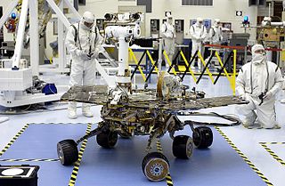
Spirit, also known as MER-A or MER-2, is a Mars robotic rover, active from 2004 to 2010. Spirit was operational on Mars for 2208 sols or 3.3 Martian years. It was one of two rovers of NASA's Mars Exploration Rover Mission managed by the Jet Propulsion Laboratory (JPL). Spirit landed successfully within the impact crater Gusev on Mars at 04:35 Ground UTC on January 4, 2004, three weeks before its twin, Opportunity (MER-B), which landed on the other side of the planet. Its name was chosen through a NASA-sponsored student essay competition. The rover got stuck in a "sand trap" in late 2009 at an angle that hampered recharging of its batteries; its last communication with Earth was on March 22, 2010.
The Earth Observing System (EOS) is a program of NASA comprising a series of artificial satellite missions and scientific instruments in Earth orbit designed for long-term global observations of the land surface, biosphere, atmosphere, and oceans. Since the early 1970s, NASA has been developing its Earth Observing System, launching a series of Landsat satellites in the decade. Some of the first included passive microwave imaging in 1972 through the Nimbus 5 satellite. Following the launch of various satellite missions, the conception of the program began in the late 1980s and expanded rapidly through the 1990s. Since the inception of the program, it has continued to develop, including; land, sea, radiation and atmosphere. Collected in a system known as EOSDIS, NASA uses this data in order to study the progression and changes in the biosphere of Earth. The main focus of this data collection surrounds climatic science. The program is the centrepiece of NASA's Earth Science Enterprise.
SCISAT-1 is a Canadian satellite designed to make observations of the Earth's atmosphere. Its main instruments are an optical Fourier transform infrared spectrometer, the ACE-FTS Instrument, and an ultraviolet spectrophotometer, MAESTRO. These devices record spectra of the Sun, as sunlight passes through the Earth's atmosphere, making analyses of the chemical elements of the atmosphere possible.

Aura is a multi-national NASA scientific research satellite in orbit around the Earth, studying the Earth's ozone layer, air quality and climate. It is the third major component of the Earth Observing System (EOS) following on Terra and Aqua. Aura follows on from the Upper Atmosphere Research Satellite (UARS). Aura is a joint mission between NASA, the Netherlands, Finland, and the U.K. The Aura spacecraft is healthy and is expected to operate until at least 2023, likely beyond.
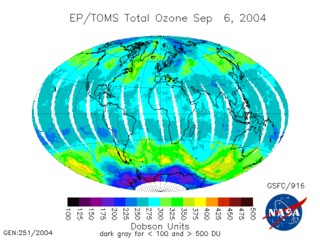
The Total Ozone Mapping Spectrometer (TOMS) was a NASA satellite instrument, specifically a spectrometer, for measuring the ozone layer. Of the five TOMS instruments which were built, four entered successful orbit. The satellites carrying TOMS instruments were:
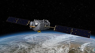
The Orbiting Carbon Observatory (OCO) is a NASA satellite mission intended to provide global space-based observations of atmospheric carbon dioxide. The original spacecraft was lost in a launch failure on 24 February 2009, when the payload fairing of the Taurus rocket which was carrying it failed to separate during ascent. The added mass of the fairing prevented the satellite from reaching orbit. It subsequently re-entered the atmosphere and crashed into the Indian Ocean near Antarctica. The replacement satellite, Orbiting Carbon Observatory-2, was launched 2 July 2014 aboard a Delta II rocket. The Orbiting Carbon Observatory-3, a stand-alone payload built from the spare OCO-2 flight instrument, was installed on the International Space Station's Kibō Exposed Facility in May 2019.

Over the last two centuries many environmental chemical observations have been made from a variety of ground-based, airborne, and orbital platforms and deposited in databases. Many of these databases are publicly available. All of the instruments mentioned in this article give online public access to their data. These observations are critical in developing our understanding of the Earth's atmosphere and issues such as climate change, ozone depletion and air quality. Some of the external links provide repositories of many of these datasets in one place. For example, the Cambridge Atmospheric Chemical Database, is a large database in a uniform ASCII format. Each observation is augmented with the meteorological conditions such as the temperature, potential temperature, geopotential height, and equivalent PV latitude.

The ozone monitoring instrument (OMI) is a nadir-viewing visual and ultraviolet spectrometer aboard the NASA Aura spacecraft. Aura flies in formation about 15 minutes behind Aqua, both of which orbit the Earth in a polar Sun-synchronous pattern. Aura was launched on July 15, 2004, and OMI has collected data since August 9, 2004. OMI can distinguish between aerosol types, such as smoke, dust, and sulfates, and can measure cloud pressure and coverage, which provide data to derive tropospheric ozone. OMI follows in the heritage of TOMS, SBUV, GOME, SCIAMACHY, and GOMOS. OMI measurements cover a spectral region of 264–504 nm (nanometers) with a spectral resolution between 0.42 nm and 0.63 nm and a nominal ground footprint of 13 × 24 km2 at nadir. The Aura satellite orbits at an altitude of 705 km in a sun-synchronous polar orbit with an exact 16-day repeat cycle and with a local equator crossing time of 13. 45 on the ascending node. The orbital inclination is 98.1 degrees, providing latitudinal coverage from 82° N to 82° S. It is a wide-field-imaging spectrometer with a 114° across-track viewing angle range that provides a 2600 km wide swath, enabling measurements with a daily global coverage. OMI is continuing the TOMS record for total ozone and other atmospheric parameters related to ozone chemistry and climate.

The Solar Mesosphere Explorer was a NASA spacecraft to investigate the processes that create and destroy ozone in Earth's upper of the atmosphere of Earth. The mesosphere is a layer of the atmosphere extending from the top of the stratosphere to an altitude of about 80 km (50 mi). The spacecraft carried five instruments to measure ozone, water vapor, and incoming solar radiation.
GEOMS – Generic Earth Observation Metadata Standard is a metadata standard used for archiving data from groundbased networks, like the Network for the Detection of Atmospheric Composition Change (NDACC), and for using this kind of data for the validation of NASA and ESA satellite data.

Jovian Infrared Auroral Mapper (JIRAM) is an instrument on the Juno spacecraft in orbit of the planet Jupiter. It is an image spectrometer and was contributed by Italy. Similar instruments are on ESA Rosetta, Venus Express, and Cassini-Huygens missions. The primary goal of JIRAM is to probe the upper layers of Jupiter's atmosphere down to pressures of 5–7 bars at infrared wavelengths in the 2–5 μm interval using an imager and a spectrometer. The Jupiter's atmosphere and auroral regions are targeted for study. In particular it has been designed to study the dynamics and chemistry in the atmosphere, perhaps determining the how Jovian hot spots form.

Lunar Flashlight was a low-cost CubeSat lunar orbiter mission to explore, locate, and estimate size and composition of water ice deposits on the Moon for future exploitation by robots or humans.
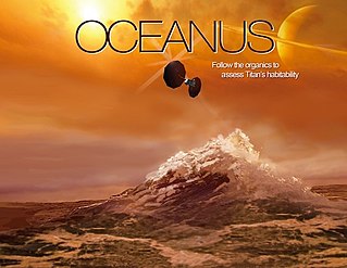
Oceanus is a NASA/JPL orbiter mission concept proposed in 2017 for the New Frontiers mission #4, but it was not selected for development. If selected at some future opportunity, Oceanus would travel to Saturn's moon Titan to assess its habitability. Studying Titan would help understand the early Earth and exoplanets which orbit other stars. The mission is named after Oceanus, the Greek god of oceans.

Carrie Anderson is an American planetary scientist at NASA's Goddard Space Flight Center.

Tropospheric Emissions: Monitoring of Pollution (TEMPO) is a space-based spectrometer designed to measure air pollution across greater North America at a high resolution and on an hourly basis. The ultraviolet–visible spectrometer will provide hourly data on ozone, nitrogen dioxide, and formaldehyde in the atmosphere.