Advanced Spaceborne Thermal Emission and Reflection Radiometer

Last updated

ASTER image draped over terrain model of Mount Etna Etna TAS2002209.jpg
ASTER image draped over terrain model of Mount Etna

The Advanced Spaceborne Thermal Emission and Reflection Radiometer (ASTER) is a Japanese remote sensing instrument onboard the Terra satellite launched by NASA in 1999. It has been collecting data since February 2000.

Contents

ASTER image of Rub' al Khali (Arabia's Empty Quarter) Rub' al Khali (Arabian Empty Quarter) sand dunes imaged by Terra (EOS AM-1).jpg
ASTER image of Rub' al Khali (Arabia's Empty Quarter)

ASTER provides high-resolution images of Earth in 14 different bands of the electromagnetic spectrum, ranging from visible to thermal infrared light. The resolution of images ranges between 15 and 90 meters. ASTER data is used to create detailed maps of surface temperature of land, emissivity, reflectance, and elevation. [1]

In April 2008, the SWIR detectors of ASTER began malfunctioning and were publicly declared non-operational by NASA in January 2009. All SWIR data collected after 1 April 2008 has been marked as unusable. [2]

The ASTER Global Digital Elevation Model (GDEM) is available at no charge to users worldwide via electronic download. [3]

As of 2 April 2016, the entire catalogue of ASTER image data became publicly available online at no cost. [4] It can be downloaded with a free registered account from either NASA's Earth Data Search delivery system [5] or from the USGS Earth Explorer delivery system. [6]


ASTER bands

ASTER false-colour satellite image of 2010 eruption of Mount Merapi, showing evidence of a large pyroclastic flow along the Gendol River south of Mount Merapi 2010 Eruption at Mount Merapi, Indonesia (ASTER).jpg
ASTER false-colour satellite image of 2010 eruption of Mount Merapi, showing evidence of a large pyroclastic flow along the Gendol River south of Mount Merapi
BandLabel Wavelength
(μm)
Resolution
(m)
Nadir or
Backward
Description
B1 VNIR_Band10.520 - 0.6015NadirVisible green/yellow
B2VNIR_Band20.630 - 0.69015NadirVisible red
B3NVNIR_Band3N0.760–0.86015NadirNear infrared
B3BVNIR_Band3B0.760–0.86015Backward
B4SWIR_Band41.600–1.70030NadirShort-wave infrared
B5SWIR_Band52.145–2.18530Nadir
B6SWIR_Band62.185–2.22530Nadir
B7SWIR_Band72.235–2.28530Nadir
B8SWIR_Band82.295–2.36530Nadir
B9SWIR_Band92.360–2.43030Nadir
B10TIR_Band108.125–8.47590NadirLong-wave infrared
or thermal IR
B11TIR_Band118.475–8.82590Nadir
B12TIR_Band128.925–9.27590Nadir
B13TIR_Band1310.250–10.95090Nadir
B14TIR_Band1410.950–11.65090Nadir

[7]

ASTER Global Digital Elevation Model

SRTM3 vs. ASTER1 comparison (Ile d'Yeu), inaccuracies and errors of the latter are indicated by arrows Comparison SRTM3 vs ASTER.jpg
SRTM3 vs. ASTER1 comparison (Île d'Yeu), inaccuracies and errors of the latter are indicated by arrows

Version 1

On 29 June 2009, the Global Digital Elevation Model (GDEM) was released to the public. [8] [9] A joint operation between NASA and Japan's Ministry of Economy, Trade and Industry (METI), the Global Digital Elevation Model is the most complete mapping of the earth ever made, covering 99% of its surface. [10] The previous most comprehensive map, NASA's Shuttle Radar Topography Mission, covered approximately 80% of the Earth's surface, [11] with a global resolution of 90 meters, [12] and a resolution of 30 meters over the USA. The GDEM covers the planet from 83 degrees North to 83 degrees South (surpassing SRTM's coverage of 56 °S to 60 °N), becoming the first earth mapping system that provides comprehensive coverage of the polar regions. [11] It was created by compiling 1.3 million VNIR images taken by ASTER using single-pass [13] stereoscopic correlation techniques, [8] with terrain elevation measurements taken globally at 30-meter (98 ft) intervals. [10]

Despite the high nominal resolution, however, some reviewers have commented that the true resolution is considerably lower, and not as good as that of SRTM data, and serious artifacts are present. [14] [15]

Some of these limitations have been confirmed by METI and NASA, who point out that the version 1 of the GDEM product is "research grade". [16]

Version 2

STL 3D model of Penang Island terrain based on ASTER Global DEMv2 data Penang island.stl
STL 3D model of Penang Island terrain based on ASTER Global DEMv2 data

During October 2011, version 2 of Global Digital Elevation Model was publicly released. [17] This is considered an improvement upon version 1. These improvements include increased horizontal and vertical accuracy, [18] better horizontal resolution, reduced presence of artifacts, and more realistic values over water bodies. [3] However, one reviewer still regards the Aster version 2 dataset, although showing 'a considerable improvement in the effective level of detail', to still be regarded as 'experimental or research grade' due to presence of artefacts. [19] A 2014 study [18] showed that over rugged mountainous terrain the ASTER version 2 data set can be a more accurate representation of the ground than the SRTM elevation model.

Version 3

ASTER v3 was released on August 5, 2019. [20]

The improved GDEM V3 adds additional stereo-pairs, improving coverage and reducing the occurrence of artifacts. The refined production algorithm provides improved spatial resolution, increased horizontal and vertical accuracy. The ASTER GDEM V3 maintains the GeoTIFF format and the same gridding and tile structure as V1 and V2, with 30-meter postings and 1 x 1 degree tiles. Version 3 is claimed to have significant improvements over the previous release. Automated processing of 2.3 million scenes from the ASTER archive was used to create the ASTER GDEM, which included stereo-correlation to create individual scene-based ASTER DEMs, masking to remove cloudy pixels, stacking all cloud-screened DEMs, removing residual bad values and outliers, averaging selected data to create final pixel values.

Related Research Articles

<span class="mw-page-title-main">Digital elevation model</span> 3D computer-generated imagery and measurements of terrain

A digital elevation model (DEM) or digital surface model (DSM) is a 3D computer graphics representation of elevation data to represent terrain or overlaying objects, commonly of a planet, moon, or asteroid. A "global DEM" refers to a discrete global grid. DEMs are used often in geographic information systems (GIS), and are the most common basis for digitally produced relief maps. A digital terrain model (DTM) represents specifically the ground surface while DEM and DSM may represent tree top canopy or building roofs.

<span class="mw-page-title-main">NASA WorldWind</span> Open-source virtual globe

NASA WorldWind is an open-source virtual globe. According to the website, "WorldWind is an open source virtual globe API. WorldWind allows developers to quickly and easily create interactive visualizations of 3D globe, map and geographical information. Organizations around the world use WorldWind to monitor weather patterns, visualize cities and terrain, track vehicle movement, analyze geospatial data and educate humanity about the Earth." It was first developed by NASA in 2003 for use on personal computers and then further developed in concert with the open source community since 2004. As of 2017, a web-based version of WorldWind is available online. An Android version is also available.

<span class="mw-page-title-main">Marmolejo</span> Mountain in Argentina

Volcán Marmolejo is a 6,108 m (20,039 ft) high Pleistocene stratovolcano in the Andes on the border between Argentina and Chile. It is located 9 km (6 mi) NNE of the active San José volcano, and is the southernmost 6,000 m (19,685 ft)-plus peak in the world. The Argentine portion is within the Argentinean protection area of Provincial Reserve for Multiple Use and Natural Recreation Manzano / Portillo de Piuquenes. It is on the border of two provinces: Argentinean province of Mendoza and Chilean province of Cordillera. Its slopes are within the administrative boundaries of the two cities: Argentinean city of Tunuyán and the Chilean commune of San José de Maipo.

<span class="mw-page-title-main">Tipas</span> Mountain in Argentina

Cerro Walther Penck is a massive complex volcano in the Andes, located in northwestern Argentina, Catamarca Province, Tinogasta Department, at the Puna de Atacama. It is just southwest of Ojos del Salado, the highest volcano in the world. Walther Penck itself is perhaps the third highest active volcano in the world.

<span class="mw-page-title-main">Shuttle Radar Topography Mission</span> Project to create a digital topographic database of Earth

The Shuttle Radar Topography Mission (SRTM) is an international research effort that obtained digital elevation models on a near-global scale from 56°S to 60°N, to generate the most complete high-resolution digital topographic database of Earth prior to the release of the ASTER GDEM in 2009. SRTM consisted of a specially modified radar system that flew on board the Space Shuttle Endeavour during the 11-day STS-99 mission in February 2000. The radar system was based on the older Spaceborne Imaging Radar-C/X-band Synthetic Aperture Radar (SIR-C/X-SAR), previously used on the Shuttle in 1994. To acquire topographic data, the SRTM payload was outfitted with two radar antennas. One antenna was located in the Shuttle's payload bay, the other – a critical change from the SIR-C/X-SAR, allowing single-pass interferometry – on the end of a 60-meter (200-foot) mast that extended from the payload bay once the Shuttle was in space. The technique employed is known as interferometric synthetic aperture radar. Intermap Technologies was the prime contractor for processing the interferometric synthetic aperture radar data.

<span class="mw-page-title-main">TerraSAR-X</span>

TerraSAR-X, is an imaging radar Earth observation satellite, a joint venture being carried out under a public-private-partnership between the German Aerospace Center (DLR) and EADS Astrium. The exclusive commercial exploitation rights are held by the geo-information service provider Astrium. TerraSAR-X was launched on 15 June 2007 and has been in operational service since January 2008. With its twin satellite TanDEM-X, launched 21 June 2010, TerraSAR-X acquires the data basis for the WorldDEM, the worldwide and homogeneous DEM available from 2014.

Ramada is a group or massif in Argentina. It has a height of 6,384 metres (20,945 ft). It's located at Calingasta Department, San Juan Province, at the Cordillera de la Ramada.

<span class="mw-page-title-main">Cerro Las Tórtolas</span> Mountain in Argentina

Cerro Las Tórtolas is a peak at the border of Argentina and Chile with an elevation of 6,145 metres (20,161 ft) metres and located at the Central Andes. It is on the border of the Argentinean province of San Juan and Chilean province of Elqui. Its slopes are within the administrative boundaries of Argentinean city of Iglesia and Chilean commune of Vicuña.

<span class="mw-page-title-main">Alto San Juan</span> Mountain in Argentina

Alto San Juan is a peak at the border of Argentina and Chile with an elevation of 6,148 metres (20,171 ft) metres. Alto San Juan is part of the Central Andes. Its territory is within the Argentinean protection area of Provincial Reserve for Multiple Use and Natural Recreation Manzano / Portillo de Piuquenes. Its slopes are within the administrative boundaries of the two cities: Argentinean city of Tunuyán (Mendoza) and Chilean commune of San José de Maipo (Cordillera).

<span class="mw-page-title-main">Pico Polaco</span> Mountain in Argentina

Pico Polaco is a mountain located in Argentina with a height of 5,950 metres (19,521 ft). It is located at Calingasta Department, San Juan Province, at the Cordillera de la Ramada.

<span class="mw-page-title-main">El Ermitaño</span> Mountain in Chile

El Ermitaño is a peak in Chile with an elevation of 6,146 metres (20,164 ft) metres located at Puna de Atacama. It is on the border of the Chilean provinces of Chañaral and Copiapó Along with Cerro Peña Blanca, lies on the southern rim of the Wheelwright Caldera.

<span class="mw-page-title-main">La Mesa (mountain)</span> Mountain in Argentina

Cerro La Mesa or La Mesa or Cerro de la Mesa is a mountain in the Cordillera de la Ramada range of the Andes, in Argentina. It has a height of 6,180 metres (20,276 ft). La Mesa means table in Spanish. The name of the mountain comes its flat and long summit ridge. Despite the dry climate of the area, there are significant glaciers flowing down the southern and the eastern flank of the mountain. Its slopes are within the administrative boundaries of the Argentinean city of Calingasta, Province of San Juan.

<span class="mw-page-title-main">Yayamari</span> Mountain in the Andes

Yayamari is a mountain in the Vilcanota mountain range in the Andes of Peru, about 6,049 metres (19,846 ft) high. It is situated in the Cusco Region, Canchis Province, Pitumarca District, and in the Quispicanchi Province, Marcapata District. Yayamari lies northeast of Sibinacocha, north of the lake named Amayuni and northwest of Huila Aje and Condoriquiña.

<span class="mw-page-title-main">Global relief model</span> Model of Earths relief including elevation and depth underwater

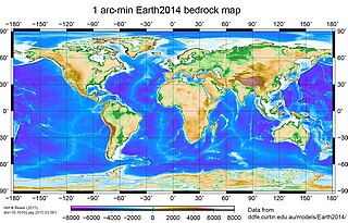
A global relief model, sometimes also denoted as global topography model or composite model, combines digital elevation model (DEM) data over land with digital bathymetry model (DBM) data over water-covered areas to describe Earth's relief. A relief model thus shows how Earth's surface would look like in the absence of water or ice masses.

<span class="mw-page-title-main">Cerro Ameghino</span>

Ameghino is a mountain in Argentina. It has a height of 5,950 metres (19,521 ft).

<span class="mw-page-title-main">Vallecitos (volcano)</span> Mountain in Argentina

Vallecitos is a mountain subrange/area in Argentina. It has a height of 6,120 metres (20,079 ft). It is located at Antofagasta de la Sierra, Catamarca Province, at the Puna de Atacama.

Laguna Blanca is a peak in Argentina with an elevation of 6,012 metres (19,724 ft) metres. Laguna Blanca is the highest peak of Sierra de Laguna Blanca, a range within Puna de Atacama, a high plateau of the Andes. It is within the protected area "Natural Provincial Reserve and Biosphere of Laguna Blanca". Cerro Laguna Blanca is located within the territory of the Argentinean province of Catamarca. Its slopes are within the administrative boundaries of two Argentine cities: Antofagasta de la Sierra and Villa Vil.

Volcan del Viento also called Gendarme Argentino 2 is a remote mountain in Argentina with an elevation of 6,028 metres (19,777 ft) metres. Volcan del Viento is within the following mountain ranges: Argentinean Andes, Puna de Atacama and Andean Volcaninc Belt. It is located at the Argentinean province of Catamarca. Its slopes are entirely within the territory of the Argentinean city of Fiambalá.

<span class="mw-page-title-main">Negro Pabellón</span> Mountain peak in Mendoza, Argentina

Negro Pabellón is a peak in Mendoza, Argentina with an elevation of 6,090 metres (19,980 ft) metres. Negro Pabellón is within the Central Andes and is the highest at Cordón de las Delicias. Its territory is within the Argentinean protection area of Provincial Reserve for Multiple Use and Natural Recreation Manzano / Portillo de Piuquenes. Its slopes are within the administrative boundaries of the Argentinean city of Tunuyán.

References

  1. Wigglesworth, Alex (6 November 2019). "Satellite image shows Kincade fire burn scar". Los Angeles Times . Retrieved 7 November 2019.
  2. "LP DAAC - ASTER User Advisory (updated: January 14, 2009)".
  3. 1 2 "METI and NASA Release Version 2 ASTER Global DEM". U.S. Geological Survey / NASA LP DAAC. Archived from the original on 21 December 2013. Retrieved 21 December 2013.
  4. "NASA, Japan Make ASTER Earth Data Available At No Cost | NASA". 31 March 2016.
  5. "Earthdata Search".
  6. "EarthExplorer".
  7. "Characteristics".
  8. 1 2 "ASTER Global Digital Elevation Map". NASA. 29 June 2009. Archived from the original on 3 July 2009. Retrieved 30 June 2009.
  9. "ASTER Imagery". NASA. 29 June 2009. Retrieved 30 June 2009.
  10. 1 2 "Most complete earth map published". BBC News . 30 June 2009. Retrieved 1 July 2009.
  11. 1 2 "NASA, Japan publish detailed map of Earth". Canada.com. 30 June 2009. Archived from the original on 4 July 2009. Retrieved 1 July 2009.
  12. "What is ASTER?". Archived from the original on 27 April 2009. Retrieved 1 July 2009.
  13. Nikolakopoulos, K. G.; Kamaratakis, E. K; Chrysoulakis, N. (10 November 2006). "SRTM vs ASTER elevation products. Comparison for two regions in Crete, Greece" (PDF). International Journal of Remote Sensing. 27 (21): 4819–4838. Bibcode:2006IJRS...27.4819N. doi:10.1080/01431160600835853. ISSN   0143-1161. S2CID   1939968. Archived from the original (PDF) on 21 July 2011. Retrieved 1 July 2009.
  14. "Virtual Earth Products Reviews". Archived from the original on 31 May 2009. Retrieved 1 July 2009.
  15. Hirt, C.; Filmer, M.S.; Featherstone, W.E. (2010). "Comparison and validation of recent freely-available ASTER-GDEM ver1, SRTM ver4.1 and GEODATA DEM-9S ver3 digital elevation models over Australia". Australian Journal of Earth Sciences. 57 (3): 337–347. Bibcode:2010AuJES..57..337H. doi:10.1080/08120091003677553. hdl: 20.500.11937/43846 . S2CID   140651372 . Retrieved 5 May 2012.
  16. "METI and NASA Release ASTER Global DEM". Archived from the original on 29 May 2009. Retrieved 1 July 2009.
  17. "Release of ASTER GDEM Version 2". Archived from the original on 29 May 2009.
  18. 1 2 Rexer, M.; Hirt, C. (2014). "Comparison of free high-resolution digital elevation data sets (ASTER GDEM2, SRTM v2.1/v4.1) and validation against accurate heights from the Australian National Gravity Database" (PDF). Australian Journal of Earth Sciences. 61 (2): 213. Bibcode:2014AuJES..61..213R. doi:10.1080/08120099.2014.884983. hdl: 20.500.11937/38264 . S2CID   3783826. Archived from the original (PDF) on 7 June 2016. Retrieved 24 April 2014.
  19. de Ferranti, Jonathan. "ASTER Digital Elevation Data". Viewfinder Panoramas, UK. Retrieved 21 December 2013.
  20. "ASTER Global Digital Elevation Map".